An almost Ghost Town on Route 66
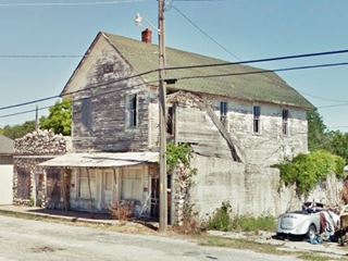
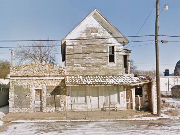
Vacant, derelict buildings on Route 66 in Avilla MO.
Index to this page
About Avilla Missouri
Facts, Trivia and useful information
Elevation: 1,122 ft (342 m). Population 99 (2024).
Time zone: Central (CST): UTC minus 6 hours. Summer (DST) CDT (UTC-5).
Avilla is a small village on Old Route 66 on the eastern edge of Jasper County, in southwestern Missouri.
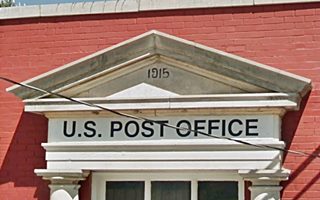
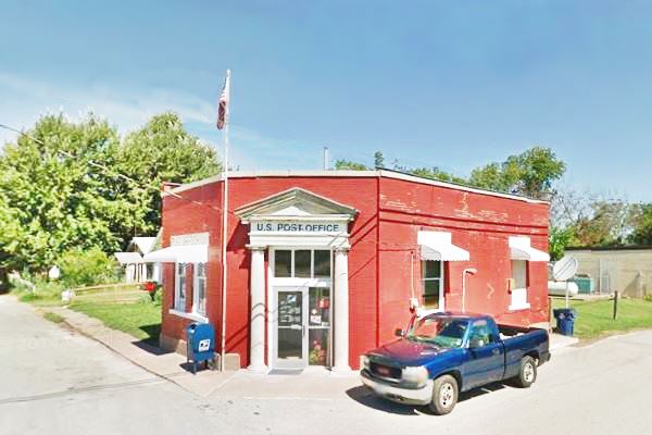
Formerly the town's bank, Avilla Post Office building was built in 1915
History of Avilla
Missouri was peopled over ten thousand years ago at the end of the last Ice Age. These Paleoindians became the hunter gatherer tribes of more recent times. Around 700 BC the Osage people moved into the Ozarks from their homeland on the Mississippi and Ohio rivers evicted by the belligerent Iroquois.
French explorers from Canada claimed the region in 1682 and named it "Louisiana" after their king Louis XIV. Napoleon sold the territory to the U.S. in 1803 and this part of vast Louisiana became the Missouri Territory in 1812 and part of the Union in 1821.
White settlement forced the Osage people to cede their land (the 1808, 1818 and 1825 treaties), moving them to a new Reservation in the Indian Territory (which would later become Oklahoma).
The first settlers arrived in what would become Avilla in the 1830s, and Jasper County was organized in 1841. Avilla's first school was called White Oak School as it was close to the creek of the same name. In 1858 D. S. Holman and A.L. Love platted the township, which they named Avilla. They became Postmaster (the post office opened in 1860) and Justice of Peace respectively.
The name: Avilla
It is said to have been named after Avilla Indiana which in turn was settled between 1836 and 1844 and named so because one of its settlers, Judge Edwin Randall liked the name which came from the Spanish word for village or hamlet: "villa".
During the American Civil War, despite Missouri being a Confederate state, the town's leaders were unionists, and after 1862 it was garrisoned by the Union Army, and did not suffer the ravages of the war. After the war it boomed while the neighboring towns were being rebuilt.
The Ghosts of Avilla
There is a local legend ("Avilla Phantom Bushwhacker") about a Confederate soldier (Rotten Johyn Reb, who was a "Bushwhacker") who remained unburied and the "Death Tree" where his skull was hung. The headless ghost is seeking revenge while he looks for his missing head.
Johnny Reb is the generic name for the Confederate soldier (The Union soldiers called them Reb, short for Rebel and Johnny) so the myth mixes many tales into one.
Avilla was located on a main stage coach line and prospered until the railway bypassed the town in its route from Springfield to Carthage. This stunted growth and the town stagnated.
Then, in the early 1900s, cars took to the roads and trails across the area, which were in terrible condition so the Ozark Trails Association was created in 1913 by W. H. "Coin" Harvey (1851-1936), a teacher and businessman and entrepreneur he believed in good roads and promoting car travel and tourism.
Route 66 was created in 1926 and aligned along the Ozark Trail and those driving along the Mother Road in the 1930s brought relief to the small village during the Depression. Finally, US66 was bypassed by I-44 that had opened in 1958 from Oklahoma City to Joplin and continued east along former US-166, south of Avilla, to Springfield. Despite the new freeway, Route 66 remained in use in Avilla until 1978.

Where to Lodge in Avilla, Missouri
Find your hotel room and lodging close to Avilla, in neighboring Carthage
> > Book your hotel in neighboring Carthage
More Lodging near Carthage along Route 66
There are several hotels in the area close to this town. Alternatively you can also find your accommodation along Route 66 in the neighboring towns and cities in Missouri. We list them below (from east to west):
On Route 66's Main alignment in MO
Eastwards
Westwards
- Hotels in Kansas
- Baxter Springs KS
- Galena KS
- Riverton KS
- Hotels in Oklahoma
- Miami OK
>> Check out the RV campgrounds in nearby Carthage
Weather in Avilla
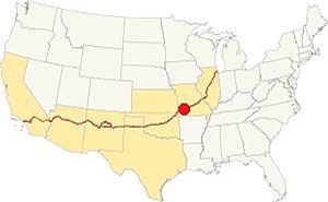
Location of Avilla. on Route 66
Avilla has a wet & subtropical climate with dry and cold winters and very wet summers (the rainy season spans from April to July, with thunderstorms).
Averages rainfall is 46.5 in (1.180 mm) yearly plus some 11.9 in. of snow (30 cm) in winter.
The winter (Jan) average high is 44.9°F (7.2°C) and the average low is below freezing, with 25.0°F (-3.9deg;C). The summer (Jul) average high is 90.6°F (32.6°C) and the average low is 69.° (21.1°).
Tornado risk
Avilla is located within the infamous "Tornado Alley" and Japer County has an average of 6 tornado strikes per year.
Tornado Risk: read more about Tornado Risk along Route66.
Map of Route 66 in Avilla, MO
Heading West from Spencer and over the next 30 miles, Route 66 has a clear east-to-west alignment and goes through a series of small villages strung along it: Heatonville, Albatross, Phelps, Rescue, Plew, and Avilla. This straight alignment ends on the eastern side of Carthage.
This is the map of this section.
Route 66 Alignment near Avilla
Visit our pages, with old maps and plenty of information about US 66's alignments.
- Route 66 in Kansas (next)
- Springfield to Joplin (Avilla's)
- Rolla to Springfield (previous)
Route 66 Sights in Avilla
A Vanishing Town
Historic context, the classic Route 66 in Avilla
Jack DeVere Rittenhouse wrote his book "A Guide Book to Highway 66" in 1946 and it provides a very good idea of what Route 66 was like during its heyday. Rittenhouse mentions the town as follows.
Avilla (Pop 178) Gas, cafe, stores Rittenhouse (1946)
He added that it was an important agricultural trading and supply center, and that one mile east of the town were two gas stations and the "White Oak Cabins" (could he have been referring to Nichol’ Garage - Hardesty Station & Cabins that are 1.3 mi east of Avilla?
He added that Log City (4 mi. east) and Stone City (3 mi.) were resorts with cabins built of logs and stone, and had filling stations and cafes (we describe these sites in our Plew webpage).
Tour the route 66 landmarks in Avilla
We will begin our tour on the eastern side of the town, coming from Plew. This is the western part of the Ozarks region.
The Ozarks
Route 66 crossess the Missouri Ozarks all the way from St. Louis to Kansas state line.
The Ozarks is a highland region in south-central Missouri, northern Arkansas and northwestern Oklahoma. It covers 47,000 sq. mi. (122.000 km2). The name drives from French "aux Arcs" "aux" meaning "from" or "at", and "Arcs" is an abbreviation of "Arkansas", meaning: "From ⁄ at Arkansas".
The karst limestones of the Springfield Plateau (Joplin to Stafford along US 66) has sinkholes, caves and springs, which are also found in the dolostone rocks of the Salem Plateau north and east of Stafford towards St. Louis.
The countryside has gently rolling hills, and Missouri is known as the "Cave State" with more than 6,000 caves, mostly in the Ozarks.
Drive west from Plew, after 1.7 miles, to your right, just after crossing County Rd. 10 is an old tourist complex on the north side of the highway.
Nichol’ Garage - Hardesty Station & Cabins
Roughly one and a half miles east of Avilla. (Map showing the spot). It has a log cabin, gas station and garage plus a small pumphouse.
Log cabin
The building on the eastern tip of the property is a log cabin. It has a gable roof and faces the highway. It was moved here from another unknown location, and was rented to travellers who needed an overnight room.
Next to it is a small pumphouse with stucco walls.
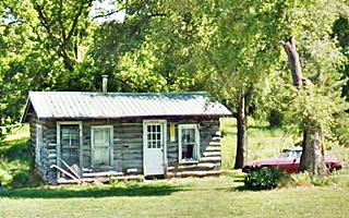
Hardesty Gas Station
Listed in the 1993 Missouri Route 66 Survey, the property has several buildings. The filling station is a two-room bungalow-style wooden building with a gable roof. It faces the highway, it has a single door entrance flanked by two double-hung windows.
It served as a gas station and also sold beer in the room at the back.
Ms. Mabel Hardesty ran it for some time in the 1930s-40s and then she sold it to Dick Clark. He hung himself here in 1948!
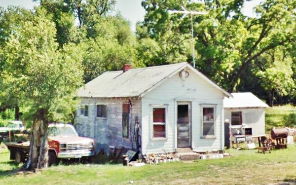
Nichols' Garage
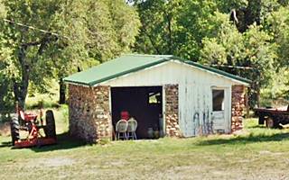
On the western side of the property,this gable roof building dates back to 1930 in stone, it has a single service bay and a small office.
Midway Service & Cafe
Continue west for 1.5 miles, and set upon a low grassy hill half a mile west of White Oak Creek is this old cafe and gas station (to your right).
Another building from the 1930s, it was moved to this location in the 1950s, and Mary Manynard bought it together with her husband in 1953. The complex included a gas station which burned down in the 1970s.
It has a side gabled roof and is built in gold and red stone (in "giraffe style).
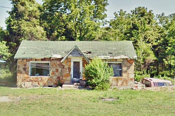
Head west and you will reach Avilla. You will notice two old buildings on the north side of the road, to your right.
They are pictured at the top of this page: the stone building was a grocery store (Old French's) and the two-story wood frame one was the "Odd Fellows Lodge".
Odd Fellows Lodge
The building to the right. It is a wood frame building built in Victorian style around 1885, it was the "Odd Fellows Lodge" meeting hall and the most impressive building on Route 66 in Avilla.
The Odd Fellows Lodge formed its chapter in Avilla at a very early date (ca. 1870s) together with the Freemasons.
The Independent Order of Odd Fellows (IOOF) (Odd Fellows for short) is a secret society without any political or sectarian orientation. It was founded by Thomas Wildey in Baltimore, USA in 1819 (check their website).
Next to it is the adjacent grocery, a stone building sandwiched between "Bernie's Bar" to the west and Odd Fellows building to the east:
Stone Grocery Store
This stone building has two boarded windows and a door in the middle. It is a commercial structure sharing a common wall with the lodge. The stone rubble facade is randomly laid and it gives the building a strange appearance.
Former Flo's Tavern
What is nowadays Bernie's Bar used to be Flo's Tavern it was run by Thomas W. Melugin (1903 - 1968) and his wife Florida Pratt Melugin (1910 - 1995). They had married (he for a second time) in 1947 and had two children.
Apart from the tavern, they also ran the Hotel next to it (we haven't been able to identify the building).
Brabato's Phillips 66 Site (Gone)
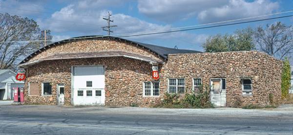
The next block, between Short and Lamar streets is now vacant, but at one time there was a magnificent Phillips 66 service station here built by Tom Brabato in 1930 using local rocks.
Below is a picture of it, taken in 1979 by John Margolies. This is a street view of the same spot nowadays.
On the next corner is the City Park and Murals.
City Park and Murals
On the NW corner of Lamar, to your right. It is the small park with a gateway and a pavilion. It faces Route 66. The mural depicts a Route 66 shield in red, white and blue colors (like those of an Interstate shield), sunflowers, a tractor and a car. More murals are painted on the western side of the building.

Mural, Avilla. Source
Avilla Post Office: former Bank of Avilla
Turn right at Lamar St. and just ahead to your left is the Historic Post Office, at 205 Greenfield St, Avilla NW corner of Lamar and Greenfield. You can see it pictured further up in the page. Avilla's bank was created in 1914 with a capital of $10,000. The building opened to the public in 1915.
It was the local farmers' and merchants' bank and managed to weather the Great Depression during the 1930s.
On May 18, 1932, the "Irish O'Malley Gang" robbed the bank and kidnaped the cashier, Ivy Russell. He was later released unharmed in Carthage. The gang members were eventually jailed or shot.
In 1944 the local bank merged into the Bank of Carthage and the building remained empty until 1952 when it became the local Post Office's building. Above is a view of its pediment (with the year 1915 inscribed in it) and the two columns that support it.
19th Century Church

Avilla 1800s (United) Methodist Church, Source
On the diagonally opposite corner of the same block (go north along Lamar and take a right on Binney St.) is the old Avilla (United) Methodist Church.
It was the first church established in the town and dates back to the 1800s.
Head back to Route 66 and head west, next to the plaza is the old Semmons & Rives building. During the Civil War it was a commercial business run by D. B. Rives and T. J. Stemmons (Street View).
Old 1930s gas station
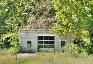
On the south side of Route 66, to your left, are two oblong box style gas station buildings from the 1930s. The first, built in concrete blocks, has two garage service bays and an office on the eastern side of the building. No pumps or canopy. Apparently vacant; see its picture below.
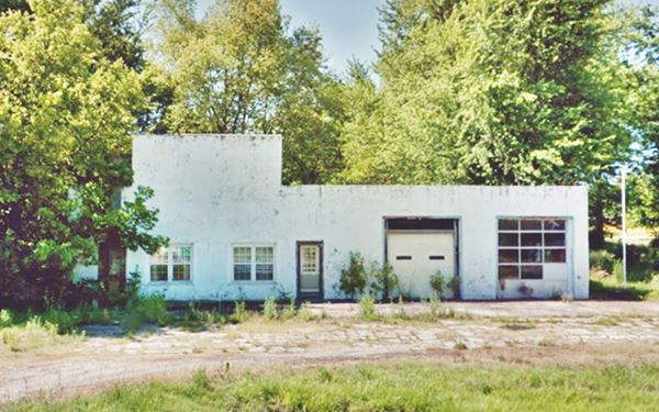
The other filling station or garage is located next to the first, on the western side of the property. Perhaps it was part of the same property. It is a small cubic-shaped building with a single service bay.
We know that James Daniel Mueller owned and operated the Standard Oil service station in Avilla for 17 years from the late 1950s onwards, it could have been this one.
Drive west from this point, leaving the town behind, after 3.8 miles, to your right, after passing County Rd. 80, is the site of the 1916 Standard Oil Filling Station.
1916 Standard Oil Filling Station Site
Originally a Standard Oil gas station, that is now safely relocated in Red Oak II. Red Oak II is a recreation of a Missouri town with original buildings from the early 1900s. It is located very close to Avilla.
The gas station has a Spanish Colonial Revival style, and is a two-room prefabricated building made with pressed metal. The walls were stamped to look like wood siding and the hip roof simulated tiles.
The roof extends forward as a canopy over the pump island and his supported by two sturdy piers.
It was manufactured by Butler Company of Kansas City in 1916, and was originally located in Carthage on the Ozark Trail, where the now closed Powers Museum stood (western side of I-49 and Route 66). Later it served traffic driving along Route 66.
In the late 1970s or early 1980s it was moved to Avilla, on the NW corner of Route 66 and County Rd. 80 (Map showing the spot).
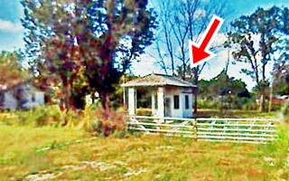
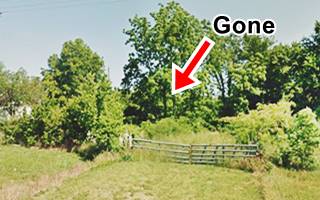
The sequence below shows it while it was there (in 2007) and the same place later, after the station was taken to Red Oak II (it moved around 2008).
Below is a picture of the old station nowadays, restored, in its new setting.

1916 Carthage Std. Oil station. Source

Avilla's Phillips 66. Source
Cottage Phillips 66
There was a Phillips 66 cottage style station in Avilla on Route 66 but, we haven't been able to find out exactly where. Like the Standard Oil from Carthage it has also been relocated in Red Oak II, it is pictured above.
Your city tour of Avilla ends here, you can continue your road trip by heading west towards Carthage.

Some sponsored content
> > Book your Hotel in Lebanon

Credits
Banner image: Hackberry General Store, Hackberry, Arizona by Perla Eichenblat
Jack DeVere Rittenhouse, (1946). A Guide Book to Highway 66
Architectural - Historic Survey of Route 66 in Missouri, Maura Johnson. 1993.
Route 66 in Missouri, NPS. 2008


