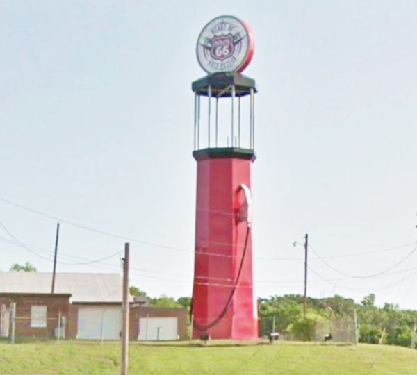
Site of the World's Tallest Gas Pump
Index to this page
Sponsored content

TheRoute-66.com is reader-supported. When you buy through links on our site, we may earn an affiliate commission at no additional cost to you.
About Sapulpa, Oklahoma
Facts, Trivia and useful information
Elevation: 715 ft. (228 m). Population: 20,544 (2010).
Time zone: Central (CST): UTC minus 6 hours. Summer (DST) CDT (UTC-5).
Sapulpa is the county seat of Creek County. Its motto is: "Oklahoma's Most Connected City".
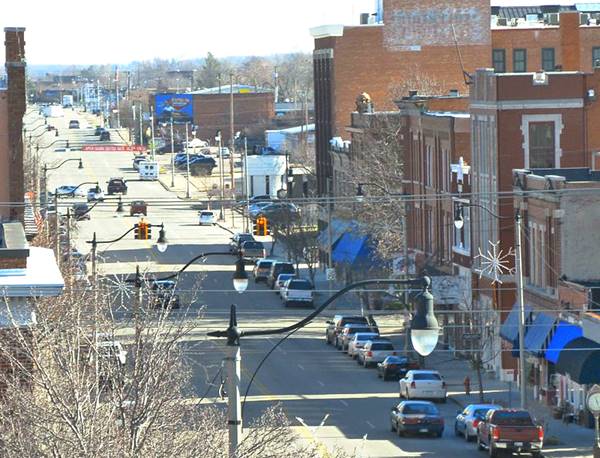
View of the town of Sapulpa
Sapulpa's History
The Name: Sapulpa
It was the name of the first settler, a Creek Indian Chief named "Sus-pul-ber"
For an early history of the region see Tulsa's History.
The first settler in the area was a native Creek leader named "Sus-pul-ber", which deformed into "Salpulpa". He was a full-blooded Creek Indian, of the Kasihta tribe who moved to the Indian Territory in the late 1840s after being forced to leave his native Osocheetown in Alabama during the relocation of the natives west of the Mississippi River.
During the Civil War, he served in the Confederate army, and when it ended, he returned to his homestead, becoming a rancher. He also opened a trading post one mile south of what would later become the town of Sapulpa, near the meeting of the Polecat and Rock Creeks.
The Creek Chief was still alive when the A&P (Atlantic and Pacific, later to be known as Frisco) railway laid its tracks through the region in 1886. They built a station and named it after him: "Sapulpa".
A post office was established in 1889 and Sapulpa became the "Record Town" for Recording District No. 8 in the Indian Territory. In those days it produced wood and walnuts.
An Indian Boarding School was established in 1893 by the Euchee Indians, taken over by the Federal government in 1898. That same year, the town was incorporated.
After Oklahoma became a state of the U.S.A., it vied with Bristow to become the county seat, winning it in 1913.
In the meantime, Frisco built a railyard and used it as a repair site for its rolling stock. It had a roundhouse, repair shops, and yards. Frisco was a big employer in Sapulpa: 700 men worked there in the 1920s.
Oil boom
In 1905 two wildcatters Galbraeath and Chesley were drilling for oil on the farmland owned by Creek Indian Ida Glenn and struck a gusher: the Glenn Pool oil. It produced 120,000 barrels (19.000 m3) a day.
Oil led to a sudden growth in Sapulpa, and the population jumped from 891 to 11,634 residents between 1900 and 1920. It was during this period that the Downtown district was built.
Route 66, commissioned in 1926 drew a growing flow of travelers through Sapulpa which continued until the Turnpike linking Oklahoma City to Tulsa was completed in the late 1950s.
Gangsters
On January 10, 1927, the Kimes, Terrill, and Barker held up the bank in Salpupa and robbed $42,000.
On February 3, 1934, after a manhunt, bandits Elliott, Moore, and Wilson were cornered in Sapulpa on Route 66, and in the shooting match that ensued, all three were shot, as were two police officers.
Getting to Sapulpa
To the northeast are Tulsa ( 14 mi.), Catoosa (31 mi), and Claremore (41 mi).
Bristow (22 mi) and Oklahoma City (102 mi) are further west, along Route 66 and I-44.
Crossroads of America
Sapulpa was located at the intersection of U.S. Highways 66 (Chicago to Los Angeles) and 75 (Canada to Mexico), and this gave it its nickname of "Crossroads of America".
Where to Stay
There are several hotels in Sapulpa and also in nearby towns along Route 66
>> Book your hotels nearby in Tulsa
Lodging Near Sapulpa
Heading West
- 54 mi. in Chandler
- 89 mi. in Edmond
- 102 mi. in Oklahoma City
- 117 mi. in Yukon
>> There are several RV campgrounds close to Sapulpa.
Sapulpa’s Weather

Location of Sapulpa on Route 66
Sapulpa has a temperate climate with occasional thunderstorms, hail, and tornados.
The average high during January is 48°F, with a low of 27°F (8.9 & -2.5°C). The July the average high and low are 93 and 71°F (34 and 21.7°C). You can expect an average of 11 days per year with temperatures over 100°F (38°C).
The yearly rainfall is around 41 inches (1.040 mm) and late spring and summer are the rainiest months (May, June, and Sept.). On average 93 days, a year are rainy. Snowfall: you may encounter snow at any time between November and March, and about 9.6 inches (24.3 cm) fall every year.
Tornado Risk
Tornado Risk": Sapulpa lies within the "Tornado Alley in Oklahoma and experiences some 10 Tornado watches every year. The largest tornado in the area was an F5 in 1960 that killed 5 and injured 81.
Read more about: the risk of Tornadoes on Route66.
Map of Route 66 in Sapulpa
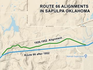
Check out the alignments of Route 66 in Sapulpa on our Oklahoma Route 66 Map webpage. It has the complete alignment of US66 across the state and all the towns along it.
The color key for Sapulpa: Pale Blue: Historic Route 66 alignment
Green: The 1926 alignment west of Sapulpa.
Sapulpa Map
Maps with the alignment of Route 66 through Sapulpa
Click on this link > > 1926 - 1952 US 66 alignment in Sapulpa
Click on this link > > Later US 66 alignment in Sapulpa
Click to read the Full description of Route 66 across Oklahoma.
Route 66 Alignment near Sapulpa
Visit our pages with old maps and plenty of information of the old US66 roadway.
- Chandler to Yukon (next)
- Tulsa to Chandler (Sapulpa's)
Route 66 landmarks & attractions
Sights in Sapulpa
- In Sapulpa (below)
- Tours & Itineraries
- State Parks

Sapulpa's Attractions
Sapulpa has several attractions: The world's tallest gas pump, an original 1926 Route 66 segment with a historic bridge, a Drive-In theater, a historic downtown district, and a vintage 1920s service station plus several more classic gas stations.
Start your tour into town on US 66 just north of the freeway. At the former "Pottery factory":
Frankoma Pottery
9549 Frankoma Rd, 0.7 mi. north of I-44. The building is still there though completely modified, the only remaining structure is a stone wall that used to read "Francoma Pottery" (as you can see in this 1960s postcard) and which is still standing (street view).
The name: Frankoma Pottery
The name combines the surname of its creator "Frank" with the last three letters of the name of the state of Oklahoma: "oma".
John Frank was a professor in ceramics at the University of Oklahoma at Norman (1927-1936). He began crafting ceramics at Norman in 1933, and
in 1938 moved to Sapulpa. In 1953 he began using the local darker red clay instead of the pale Ada clay.
The hand-made pottery is known for its sculptures and dinnerware.
He worked with his wife Grace Lee until he died in 1973. After a fire in 1984, the company filed for bankruptcy in 1990. The last decades have been turbulent:
after being sold again, suffering another fire, and going broke, it has finally reponed as Frankoma Pottery and produces low volumes of artware.
Head south along Route 66 into Sapulpa proper, pass under I-44, and at the junction with New Sapulpa Road, on your right is a concrete monument, a tribute to the glass and ceramic (Frankoma) industries of Sapulpa (Street View).
Crystal City of the Southwest
The abundance of natural gas from the Glenn Pool oil and gas field induced several glass manufacturing companies to build plants in Sapulpa. The first was Premium Glass Company in 1912. Bartlett-Collins Co., a tableware producer and beverage container maker St. Gobain (formerly Liberty Glass Co., established in 1918) still produce glass in the town. But the other plants have closed: window glass maker Sunflower Glass Co. and jar producer Schramm Glass Factory.
Continue southbound and you will pass by the site of the former "Diamond Cafe":
Norma's Diamond Cafe - Gone
The Diamond Truck Stop Cafe on North Mission St. was an icon during the heyday of Route 66. Norma died in 2000 and the cafe is now closed. Another business now uses the premises: Trikntrux. (Visit it on the corner of E. Denton Ave. and Route 66).
Head south and then take a right along E. Dewey Ave. and head west.
Three Vintage Service Station
1. To your left, on the SE corner of S. Linden St. and E. Dewey Ave. is what used to be a gas station with an "icebox" office of the 1930s (?) with a flat-roofed canopy that was built later over the concrete filling bay. (See photo).
2. Ahead, on the NW corner of N. Birch St. is another former 1960s service station with its large flat-roofed canopy and two filling bays and 2-door garage. It is now a used car sales shop. Street View.
3. Cross the railroad and to your right, on the NE corner of E. Dewey and N. Maple street is yet another former gas station which now is an auto lot. Street View
Just ahead, after crossing Elm, is the "Historic District".
Sapulpa Downtown Historic District
Historic district
Between Hobson Avenue, Elm, Lee Ave. and Main, Sapulpa. This is a nine-block area of the town that was the commercial center along Route 66. Its buildings were mostly built between 1904 and 1952.
Oil wealth from the neighboring Glenn Pool Oil field sparked a construction boom after 1905; many commercial buildings were built in the typical Commercial Style (some Classical Revival and Tudor Revival styles can also be seen in the district). Main sites: the Creek County Courthouse, the historic Public Library, and the Post Office.
Giant Chair - Gone

Giant Chair Sapulpa, the 1930s.
This chair preceded the "World's Second Largest Rocking Chair" on Route 66 in Fanning, Missouri by several decades. It was located at the north end of Sapulpa and was a favorite spot for photographs: the tourists would climb onto the gigantic chair to have their photograph taken. It was made by the Rule Furniture Co.
The Wilson Brothers Furniture Company was purchased by Rule and Milford Davis in 1937, and its name changed to Davis Rule furniture. Ten years later, Rule acquired Davis' share, creating Rule Furniture Co., which he ran until he closed it when he retired in 1989, at the age of 90.
Take a right on S. Water St. and one block ahead is the old "Waite Phillips service station":
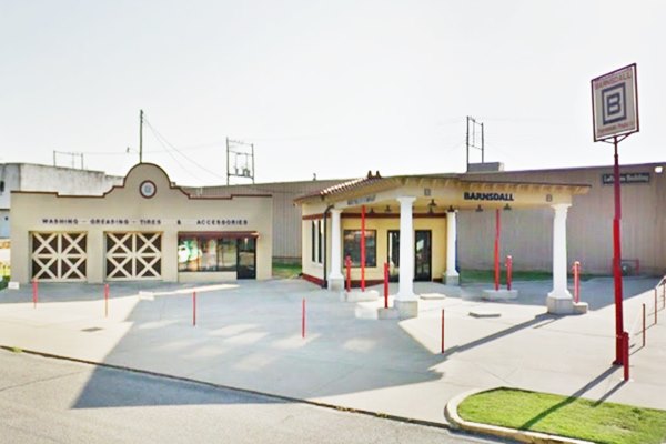
Waite Phillips Filling Station Museum
26 E Lee Ave, Sapulpa, SW corner of S. Water St. The original building was built in 1923 by Waite Phillips, it served as a filling station. And did so until Route 66 was replaced by I-44 which bypassed Salpupa.
It was restored by the Sapulpa Historical Society and is currently used as a museum that houses vintage cars from the 1920s.
Waite Phillips Filling Station, Sapulpa
> Read more about Brick paved sections of Route 66.
Across the road from the service station is the "Museum":
Sapulpa Museum
At 100 E. Lee Ave. It exhibits artifacts, photographs, and replicas of early Sapulpa from the sheriff's office to a diorama of the Frisco Railroad shops. Located in the old Willis Building. It also has Native American artifacts.
Get your Oklahoma Route 66 Passport stamped here (website: sapulpahistory.org)
Head back towards E. Dewey Ave. and turn left, westbound. It becomes Route 66 after crossing Main Street. Continue for 1 mile and to your right, when you reach the City Golf Course is the newest Route 66 landmark in Sapulpa:
The World's Tallest Gas Pump
Route 66 Americana
13 Sahoma Lake Rd, Sapulpa. This is a relatively new Route 66 Landmark. It was completed in May 2018.
The original plan was to build a 66 foot-tall gas pump with an observation deck. But due to the structural requirements the deck imposed, it was scrapped.
The Museum
It was commissioned by the Route 66 Auto Museum and built next to it. It is the work of volunteers, and it won the 2018 "Best New Attraction in Oklahoma" award.
The Museum is open from Tue. to Sat. 10 AM-4 PM and Sun. 12-4 PM. There is an admission fee.
Visit the museum's website: heartofroute66.org
World's Tallest Gas Pump - Route 66, Sapulpa
Head back to Route 66 and head west. Just ahead, to your right is a fork in the road leading to the "Historic Bridge" and the Original Route 66 alignment west of Sapulpa.
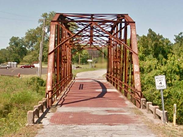
Bridge #18 at Rock Creek
Listed in the National Register of Historic Places
Old Route 66 and Rock Creek, Tulsa, OK.
An original steel truss bridge was built in 1924 along the original Route 66 1926 alignment.
It is one of the remaining steel-truss bridges that carried Route 66 in Oklahoma. This particular bridge is a Parker through truss bridge and, as an unusual feature, it has a brick decking (it is paved with red bricks).
It is 120 ft. long and 18 ft. wide. Its steel truss has a compound truss and a polygonal top cord which allow its long span.
It was built in 1924, just two years before Route 66 was created, and was originally part of the old Ozark Trail, which was incorporated into Route 66 when the U.S. highway system was laid down.
It remained part of Route 66 until the road was realigned in 1952. It still carries traffic as Historic Route 66.
Historic Rock Creek Bridge, Route 66, Sapulpa
Just past the bridge are the remains of the "Drive-in Theater":
Teepee Drive-In Theater
West Ozark Trail (Map showing location).

Satellite view, Tepee Drive-In Theater
Its remains are located on the left side of the Old (Ozark Trails Rd.) Route 66, near the Historic Bridge.
It was built in 1950 and was open until 1999. See its Street View.
Drive-In Theaters
They were outdoor cinemas with a large movie screen and a projection booth. Some had playgrounds for children and picnic tables. There was a concession selling soft drinks and fast food. The customers viewed the films from their cars and heard the audio using loudspeakers located at each parking spot. Later AM or FM radio broadcasting was used and the soundtrack was picked up by the car's radio.
Color TV, VCRs, and the rise in real estate costs led to this mostly summertime business to fade away and drop its market share from a peak of 25% of the market to barely 1.5% nowadays.
Continue west.
Dixieland Amusement Park
On Old Route 66 and Dixieland Drive (Location map).
The park opened in 1927 along the historic section of Route 66. It had a very large swimming pool fed by a natural spring. The park closed in 1951. Jack DeVere Rittenhouse "A Guide Book to Highway 66" published in 1946 does not mention its name, but refers to it: "Leaving Sapulpa you pass the municipal golf course (L) at 13 mi. (110 mi). Soon afterwards, at 16 mi. (107 mi.) is a roller skating rink and gas station. Just beyond here you begin climbing a one-mile length of winding road...", the skating rink is "Dixieland Park".
A steak house with the same name operated between 1965 and 1978. A street there (Dixieland Drive) remembers the park.
Further ahead is an underpass where Route 66 went under this railroad bridge, built in 1925. The road then turns south and meets the later alignment. And this is the end of our Sapulpa City tour.
More Tours. Nearby Route 66 Towns
Oakhurst
Almost a Ghost Town
Pop. 2010, 2,185. South of Tulsa and north of Sapulpa, set to the west of I-40, along what once was Route 66, it is a small and almost abandoned town in Tulsa County 4 miles from Tulsa.
The Creek Indian George Taylor owned the plot of land that would become Taneha (Creek for "oil is below"). It was platted in 1909 and renamed "New Taneha". Frisco Railroad built a depot there under that name. In those days Southwest Blvd, which would later become Route 66 was known as "Sapulpa Road".
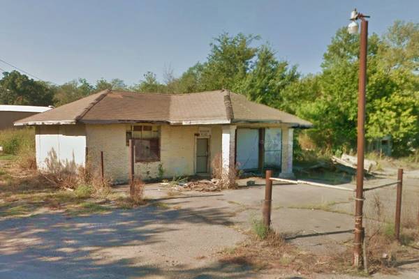
The photo below is Turney's & Casey's was a filling station, garage, diner, and cafe. Today it is an abandoned shell on S63rd W Ave and Southwest Blvd., Oakhurst:
The area was sold to O. C. Graves in 1915 who promoted the real estate, build sidewalks and natural gas streetlights.
The post office was built in 1909 at Bowden Switch, on the railroad. A new one opened in 1918, and one was opened in 1927, named Oakhurst.
Oil and natural gas made it a prosperous place in the early 1900s. Route 66 passed through the town in 1926 and hotels sprung up. However the Depression stunted growth, lots remained empty and people moved out.
Historic Old Alignment of Route 66 west of Sapulpa
West Sapulpa Segment (1924-1952)
This segment is 3.3 miles long and was originally part of the unpaved "Ozark Trails" built in 1915. In 1921 it became State Highway No. 7 as part of a project to link Sapulpa and Bristow with a modern highway. The roadbed had two lanes and a width of 18 ft., and was paved in 1924-25 with Portland Concrete. It even has a 2-mile section with a concrete retaining wall and guardrail.
In 1926 it was incorporated into Route 66 and is in use until this day as OK-66 (Historic Route 66), although its original concrete has been overlaid with later asphalt paving.
This segment includes the historic Bridge #18 at Rock Creek described above.
A straighter and wider alignment for Route 66 was built further south which replaced this section in 1952.
See a Map of the old road.
Route 66 Map Oakhurst to Kellyville through Sapulpa
This is the Map of Route 66 from Oakhurst to Kellyville it is the 1926 to 1960s alignment and includes de western segment built in 1952 to replace the meandering "historic section" west of Sapulpa.
Route 66 Trivia in Sapulpa
The road meanders through the countryside, among trees, blending in with it, instead of cutting across it in straight lines. It is a good example of the days when the trip was as important as the destination.
Outdoors & State Parks
Heyburn Lake Park
Just northwest of Sapulpa. It is a lake on Polecat Creek just north of Kellyville. An ideal place for swimming, trekking, boating, fishing, camping, with an RV park. Full information: Heyburn Lake U.S. Army Corps of Engineers
See the nearby towns for outdoor recreation; we mention them on our Tulsa page: State Parks near Sapulpa (in Tulsa)
Some sponsored content
>> Book your Hotel in Tulsa


Credits
Banner image: Hackberry General Store, Hackberry, Arizona by Perla Eichenblat
Jack DeVere Rittenhouse, (1946). A Guide Book to Highway 66
www.cityofsapulpa.net Official city website.
Oklahoma Historical Society
George H. Shirk, Oklahoma Place Names


