Wacky Sight on Route 66
Route 66 Red Rocker
Index to this page
About Fanning Missouri
Facts, Trivia and useful information
Elevation: 1,047 ft (319 m). Population n⁄a (2024).
Time zone: Central (CST): UTC minus 6 hours. Summer (DST) CDT (UTC-5).
Fanning is a small unincorporated community located on Old Route 66 in western Crawford County, central Missouri in the Ozarks foothills.
History of Fanning
Visit our Cuba page where we detail the History of Cuba (county seat) and the region.
The post office at Fanning opened in 1887 and closed for good in 1953. The small community had a church and school. Now it has a few scattered homes, many of them on the south side of the railroad.
The Name: Fanning
The town is named after a family of four brothers from Limerick, Ireland, John, Tom, Matt and Jim Fanning who worked on the "Frisco" Railroad as it advanced across Missouri until they reached this area west of Cuba and settled down. The surname derives from old English "foenn" or "fenn", a marsh or bog. Therefore it applied to those living in a marshy area.
Route 66 provided additional income to the town and there were two service stations on it. In the early 1950s it became a four-lane highway, now under I-44. Fanning was bypassed and left to its own devices.
Getting to Fanning
You can reach Fanning along historic Route 66 and Interstate I-44 that links it with Springfield, Tulsa and Oklahoma City in the west and with Cuba, Eureka and St. Louis in the east. US 63 runs through Rolla to the west and US 50 passes through Villa Ridge to the east.

Where to Lodge in Fanning, Missouri
Accommodation and hotels in neighboring towns.
> > Book your hotel in neighboring Cuba
More Lodging near Fanning along Route 66
There are several hotels in the area close to this town. Alternatively you can also find your accommodation along Route 66 in the neighboring towns and cities in Missouri. We list them below (from east to west):
On Route 66's Main alignment in MO
Eastwards
Westwards
- Hotels in Kansas
- Baxter Springs KS
- Galena KS
- Riverton KS
- Hotels in Oklahoma
- Miami OK
>> Check out the RV campgrounds in neighboring Cuba
Weather in Fanning

Location of Fanning on U.S. Hwy. 66
Fanning has well marked seasons, which are the combination of humid continental and humid subtropical climates. The winter (Jan), the average high is around 39°F (4°C) and the aveage low is a freezing 20°F (-7°C). The summer (Jul) average high is 89°F (32°C) with an average low of 68°F (20°C). Rainfall averages 44.5 in. (1.130 mm) yearly which ranges from 2.21 in (56 mm) in Jan. to 4.81 in (122.2 mm) in May. Snowfall is around 18.9 in. (48 cm), which falls from Dec. to Mar.
Tornado risk
Fanning is located in Missouri's "Tornado Alley" and Crawford County is struck by 7 tornados every year.
Tornado Risk: read more about Tornado Risk along Route66.
Map of Route 66 in Fanning, MO
You can find Fanning on our Route 66 Map of Missouri. It has the different alignments of the Mother road across the state, and all the towns along it.
Click on the thumbnail image to see the alignment of Route 66 through Fanning (upper right).
The original 1926 to 1930 Route 66 ran along a zigzag course west of Cuba, it crossed the railroad and in Fanning ran along its southern side. Later it was paved and realigned, becoming a regular two-lane highway until 1953. After then, the highway became the eastbound lanes of the Four-Lane Route 66 between Hofflins and Knobville. The westbound lanes ran along what would later become I-44.
After 1969 two new lanes were added to the freeway and I-44 replaced old US 66 bypassing it through Fanning.
Map with the alignment of Route 66 through Fanning
Click on this link > > US 66 alignment in Fanning
Historic U.S. highway 66, "Route 66" has been designated as an All-American Road and National Scenic Byway in the state of Missouri.
Click on the following link for a Full description of Route 66 across the state of Missouri.
The Route 66 alignment in Fanning
Visit our pages with old maps and plenty of information about US 66's alignments.
- Rolla to Springfield (next)
- Gray Summit to Rolla (in Fanning)
- Route 66 in St. Louis (previous)
Route 66 Sights in Fanning
Landmarks and Places to See
Historic context, the classic Route 66 in Fanning
The 1941 book, "Missouri, a guide to the "Show Me" state" published by the Federal WPA did not mention it, it just skipped past it, from Cuba to Rosati. Jack DeVere Rittenhouse however, does tell us, in his 1946 "A Guide Book to Highway 66" something about it:
FANNING... Pop 59... gas station but no other facilities... a town which the new US 66 almost missed, the new road almost cutting off the one store and meeting hall which comprise the community Rittenhouse (1946)
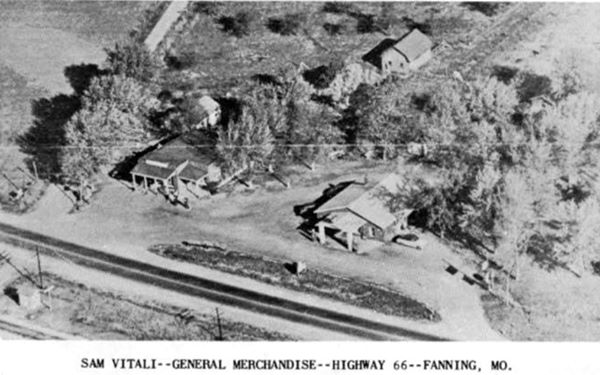
The store that Rittenhouse mentioned, has gone, but the hall survives to this day, below is a Then and Now view of the place in the 1950s and now. The old store was located very close to where the rocking chair is now located. The old hall to the right, became the current Outpost store.
Route 66 passing in front of the old store and hall ca.1950
The same view nowadays
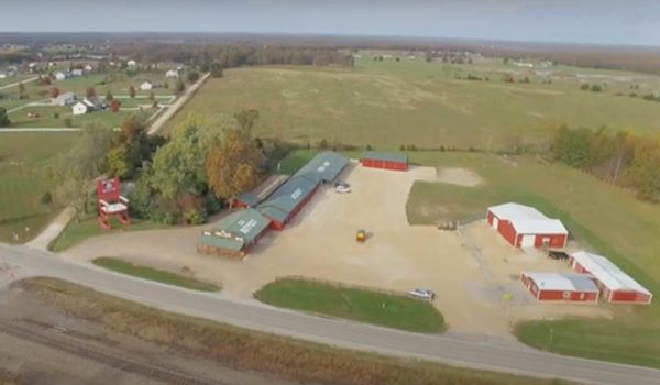
Fanning US 66 Outpost General Store
5957 Hwy ZZ, Fanning, MO. From the freeway, reach it from Exit 203 on I-44 heading 1 mi. east.

View of the Fanning US 66 Outpost General Store, Fanning, Missouri. Serge Melki
Since 2017, the old store has been renovated and the place was renamed as Route 66 Gourmet Popcorn. Its official website tells us that it features more than 250 glass bottle sodas, 75 flavors of fudge and over 300 flavors of Gourmet Popcorn.
History
Sam Vitali owned a General Store on the south side of the tracks along the first alignment of Route 66. In 1929 he and his brother-in-law Joe Bicialbi (brother of Mary, Sam's wife) purchased the Jolley farm, which was on the north side of the railroad, on the new alignment of Route 66 which was paved through town in 1930. Sam relocated on the north side of the new highway. Joe built his Speedway Garage gas station next to it. It would later became a tavern, Joe's Place.
Sam passed away in 1964 and Mary kept it open until 1972.
The store was torn down in 1980 and the tavern which at one time was the Community building was closed.
In 2007, Danny and Susan Sanazaro bought the place and refurbished the old tavern as Fanning US 66 Outpost General Store. To attract those passing buy, Dan Sanazaro came up with the "World's Largest Rocking Chair".
World's (second) Largest Rocking Chair
Route 66 Kitsch & Americana
5957 Hwy ZZ, Fanning, MO. Map showing where it is.
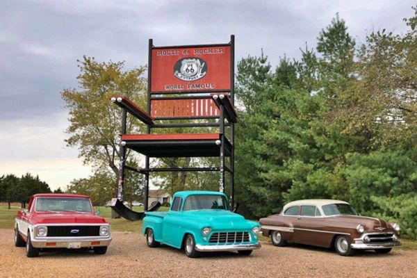
Built on April 1, 2008 it soon became the typical Route 66 "Americana" attraction, now it is known as Route 66 Red Rocker. It has 31.5 foot long rockers (9.6 m) that weigh one ton each. The whole chair was built in with steel pipes and weighs 27,000 pounds. It stands 42 feet tall (12.81 m) and is really gigantic.
Route 66 Red Rocker it is really big!
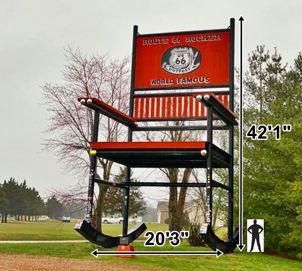
At one time it rocked but due to safety reasons Dan had it welded so now it does not "rock", and therefore lost its title to the chair in Casey Illinois. However it still is the "Largest Rocking Chair on Route 66".
After the Casey rocker displaced it, Danny Sanazaro painted it red in 2015 and changed its name to Route 66 Red Rocker.
In 2016 the Sanazros sold the property and Ryan Thompson has owned it since.
The World's Largest Rocking Chair
110 E Main St, Casey, IL
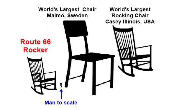
This is the official Guinness Book of Records winner: the Casey Illinois Rocking Chair. It is 56 ft. 1 in. tall (17.09 m) and 32 ft. 10 in. wide (9.99 m) its rockers measure 9.88 m long (32.4 ft). You can see it in this street view, next to Casey City Hall. It is the work of Jim Boley, Oct. 20, 2015.
There are many gigantic chairs in the U.S., and this Website on Large Chairs has photos and details.
The world's largest chair
In case you are wondering which is the largest "chair" in the world, "XXXLutz" in Cederströmsgatan 2, 212 39 Malmö Sweden has that honor, being 81.96 ft (25 m) tall. This is a street view of it.
Size comparison Route 66 rocker, the world's largest rocker and the world's largest chair.
Tours & Itineraries
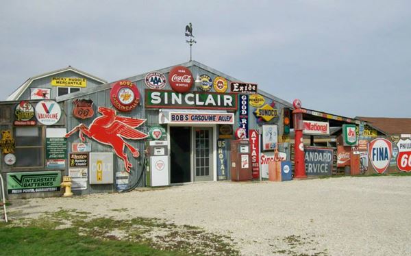
Bob’s Gasoline Alley - Closed for Good
822 Beamer Lane, just 1.2 miles north of the store and the rocker (map with directions)
Bob's Gasoline Alley has the largest collection of Historic Route 66 gasoline memorabilia in the mid-west.
Bob Mullen and his wife Darlene started collecting back in 1995. They love gas station keepsakes and collectibles from the 1950s and 60s. Both share a fascination for Route 66 and they built this awesome place to house their mementos.
Bob Mullen passed away on March 1, 2020. He was 67 years old. His collectioned was auctioned off in July 2020, and the property put on sale according to their Facebook's last post (July 2021).
Bob’s Gasoline Alley
Old Route 66 in Fanning
The first "trail" in this area was tramppled thousands of years ago by roaming buffalo and deer, crossing the plains to the Ozarks. Much later it was used by the Illinois Indians and more recently by French and English trappers and explorers. It was adopted as the main road from St. Louis towards Springfield, and in the 1850s it became the "Wire Road", that ran next to the military telegraph line from St. Louis to Fort Smith.

USGS map of Fanning in 1948, Route 66 is shown in Red.
By the early 1910s, cars had become more popular in this area, and the road was improved thanks to the lobbying carried out by the Inter-Ozarks Highway Association; the state created Missouri State Highway 14 from Saint Louis to Springfield which had a gravel surface in Fanning.
In 1926 Route 66 was aligned along MO-14 and it passed through Fanning on the south side of the railroad. In 1930, it was paved and moved north of the tracks. The original road is now named Highway ZZ and runs just south of I-44. The image shows the 1948 USGS map with Route 66 through Fanning.
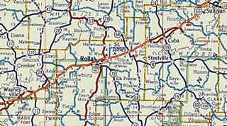
1926 Map of Route 66 from St. James to St. Louis, Missouri, notice that this first map says "formerly marked US 60" (read more about this: Route 66 was born as US 60). Fanning is in the lower left part of the map.
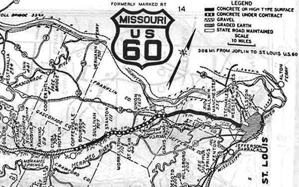
Rosati appears under its old name of "Knobview". see large map: Missouri Highway Map Archive
1950s: Four Lane Freeway

USGS map of Fanning to Hofflins through Cuba 1966, Route 66 is shown in Red.
Starting in 1953 Route 66 was upgraded to a four-lane highway and at that time and until 1969, the original 1930 Route 66 alignment became the two eastbound lanes of the new "super highway" and that two new westbound lanes were built from what is now Exit 203 past Cuba to Hofflins. Notice the arrows showing "one way" east and west from Hofflins to Fanning past Cuba.
1969 New roadbed
Beginning in 1967 the old four lane US-66 ⁄ I-44 Freeway was improved again in Missouri and the two new eastbound lanes added next to the westbound ones, forming a four-lane dual highway that replaced and bypassed the old alignment from Hofflins to Fanning. This can be seen in the 1966 USGS map of that area.
Eventually the whole of US 66 in this area was upgraded into a four lane divided highway with overpasses and it coexisted with the new interstate I-44. A state petition in 1962 to name the highway I-66 was denied by the AASHTO as that number had been used already.
Finally in 1972 the whole of Route 66 had been replaced by the Interstate system and in 1974 it was decided that the whole of US 66 from Chicago to Joplin would be eliminated and decertified. However this was delayed until I-55 in Illinois was completely brought up to Interstate standards. The signs were removed in 1977 but even then, the last segment of the old Route 66 was bypassed in 1981.
> > See the previous segment Cuba to Fanning (east)
> > See the next segment Rosati to St. James (west)
Some sponsored content
> > Book your Hotel in Lebanon

Credits
Banner image: Hackberry General Store, Hackberry, Arizona by Perla Eichenblat
The Ramsay Place Names File
Jack DeVere Rittenhouse, (1946). A Guide Book to Highway 66.


