The Jewel of Kansas Route 66!
Historic Independent Oil and Gas Service Station on Route 66
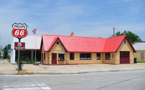
Source. Click image for St. view
Index to this page
About Baxter Springs, Kansas
Facts, Trivia and useful information
Elevation: 843 ft. (257 m). Population: 4,238 (2010 census).
Time zone: Central (CST): UTC minus 6 hours. Summer (DST) CDT (UTC-5).
Baxter Springs is located in southeastern Cherokee county, Kansas, next to Springs River and the Oklahoma State Line.

Neon Sign at the Route 66 Soda Fountain Shop, Source
The Historic Route 66 crosses the town from North to South.
Baxter Spring's History
This area has been inhabited for more than ten thousand years. The Osage Indians from Kentucky moved to this region in the mid 1600s and it is said that Chief Black Dog, stopped over at Baxter Springs during their migration to their summer hunting territories in Oklahoma. They visited the springs that gave their name to the town, as they believed that the water was good for their health. Their route, the "Black Dog Trail" was actually the first improved road in the region, a remote ancestor of Route-66.
The land was later set apart as the "Cherokee Neutral Lands", and eastern settlers were banned from entering it, but they soon entered the Region.
John J. Baxter settled with his family on a 160 acre homestead by Spring River in 1849. He opened an inn and general store (Baxter's Place); it was the first building in what would later become the town of Baxter Springs.
Baxter Springs, the name
The "Baxter" part of the name remembers the first settler, John J. Baxter, while the "Springs" part of the name comes from the mineral springs that at one time flowed from a hill just south of East 11th St.
A military road passed through his land, all the way from Fort Smith in Arkansas. It served to protect the region from the hostile Indians further west. During the civil war, the US government built some defenses: Camp Hunt, Camp Ben Butler, and Fort Baxter or Fort Blair, the site of a battle.
Baxter Springs Massacre
On October 6, 1863, a guerilla band of Confederate men (Quantrill's Raiders) attacked the fort but were repelled. They then ambushed a wagon train that was approaching the fort. Quantrill demanded the surrender of Blair's men, but then executed the captives, murdering 103 men. The fort was later abandoned and destroyed by the Union forces.
The town was incorporated in 1868 and soon after a cable ferry was built across Spring River. After 1868, the growing demand for beef in the northern states led Texas ranchers to use the town as a stopover for their cattle herds as they drove them to the markets. Baxter Springs thus became the first "Cow Town" in Kansas, corrals were built, trade and the population grew. But after the mid 1870s, once the railways reached Texas, ranchers shipped the cattle directly by train and business in Baxter Springs declined.
Lead mining and smelting revived the economy but legislation passed by the City Council preserved the town from the nasty environmental impact suffered by neighboring towns.
The town surged with the mining business and many of its buildings were built in the early 1900s. In 1926, Route 66 was created and ran along the town's Main Street. It brought prosperity and later compensated the decline in the mining industry. This wealth attracted the bandits of the early 1930s.

Most Wanted, Bonnie and Clyde. FBI
Bonnie and Clyde
During the early 1930s bank robberies were quite frequent. The famous criminal couple "Bonnie and Clyde" robbed stores in Baxter Springs and murdered police officers in neighboring Miami Oklahoma and Joplin, Missouri.
Clyde Champion Barrow and his companion, Bonnie Parker, met in Texas in January 1930 and were shot to death in Louisiana on May 23, 1934. They were suspected of kidnapping, robbery, and 13 murders.
They drove along Route 66 and they were ambushed by the police after a spectacular manhunt.
The Freeway bypasses Route 66 in Kansas
But traffic through the town came to an end when, in 1961, the new Interstate I-44 bypassed Kansas and US-66, running directly from Missouri to Oklahoma. This reduced the inflow of travelers and slowed the local economy.
The Pixar ⁄ Disney film Cars and Baxter Springs
The film's credits gives "A Special Thanks To Those Who Inspire Us On Route 66, "The Mother Road" ... ", and mentions "Dean & Paula Walker, Baxter Springs, KS."
Getting to Baxter Springs
Baxter Springs is the third and last town in Kansas to the west of the Missouri state Line (and the first, coming from Oklahoma), it is 16 miles west of Joplin, Missouri and 12 miles south of Galena, on the Kansas - Oklahoma state line. The small town of Riverton is 3 miles to the northeast.

Hotels in Baxter Springs
Where to Stay
There are several hotels in Baxter Springs. Alternatively you can also lodge in the neighboring towns in Kansas, Missouri or Oklahoma.
>> Book your Hotel in Baxter Springs
In Kansas Along Route 66
>> There is an RV campground in Baxter Springs.
Weather in Baxter Springs
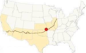
Location of Baxter Springs on U.S. Hwy. 66
The average temperature in Baxter Springs is about 60°F (15.6°C). Summers are quite hot with average highs of 91°F and lows of 70° (32.8 and 21.1°C). During winter the highs are 44°F on average while the lows are about 24°F (7.2 and -3.8 °C).
Rainfall ranges from 2.1 in. (55 mm) to 6.3 in. (160 mm). April, May, June, July and September are the rainiest months 4.6 to 6.3 in. (118 - 160 mm). On average there are 9 days of rain or drizzle per month. About 18 inches of snow fall between November and March (46 cm).
Tornado Risk. Baxter Springs is in the Kansas "Tornado Alley.
During the April 27 - 30, 2014 tornado outbreak, a tornado struck Baxter Springs. Read more about: Tornadoes on Route66.
Map of Route 66 in Baxter Springs
See the detailed alignment in our Route 66 in Kansas webpage.
Below is the interactive map of Route 66 in town.
>> Map of this segment through Baxter Spgs.
Check out Baxter Springs on our Route 66 Map of Kansas webpage. It has the alignment and the three towns along it.
This is the US 66 alignment map in Baxter Springs.
Route 66's alignment in Kansas: the Historic Route 66 through Baxter Springs
Historic U.S. highway 66, "Route 66" has been designated as an All-American Road and National Historic Byway in the state of Kansas.
Below is a map published in 1927, it shows several US highways such as US 73, US 71, and US 166. We can see Route 66 was paved from Webb City to Baxter Springs, but the alignment west of this town is different to the one recorded in most official descriptions. Instead of heading south through Quapaw to Commerce Oklahoma, it heads west and then south through Picher!
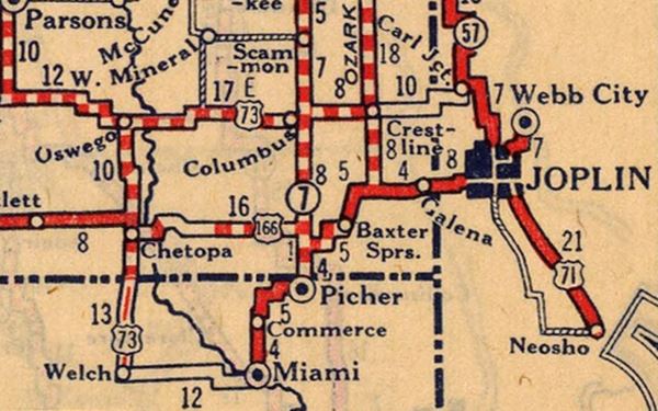
Route 66 Alignment near Baxter Spgs.
Visit our pages with old maps and plenty of information of the old US 66 roadway.
- KS-OK state line to Vinita (next)
- Route 66 in Kansas (Baxter Spring's)
- Springfield to Joplin (previous)
Sights and Attractions in Baxter Springs
The Town's Route 66 Attractions
Baxter Springs
In 1946, following the end of World War II, Jack DeVere Rittenhouse drove along Route 66 gathering data for book "A Guide Book to Highway 66". He mentioned Baxter Springs as follows:
...Merry Bales hotel; garages: Pruitt Motor Co. and Tally's; cabin camps include: Baxter, Sunbeam and 66 Camp; small business district with cafes, stores, etc.) A green and quiet town with an ancient and bloody history... Rittenhouse (1946)
We will tour the town from north to south, starting at the historic bridge.
Marsh Arch "Rainbow" Bridge
Listed in the National Register of Historic Places
The Historic Rainbow Bridge (more details on our Riverton Page: Rainbow Bridge) is just 2.5 miles north of Baxter Springs, along Route 66.
The bridge gets its name from the two concrete arches that support it. It is 130 feet (40 m) long. It was built in 1923, three years before Route 66 was created. It was repaired in 2005 and you can drive across it.
In the early 1960s a bypass was built from Baxter Springs to Riverton (Alt US 69 and US 400) because the bridge was narrow and congested, and had two sharp curves at its north and south access points (blue arrows in the map). In 1992 a new bridge was built next to it. The bridge was declared a Historic Place and saved from demolition.

1959 USGS Map of Bush Creek and U.S. 66, Riverton, Kansas. A. Whittall
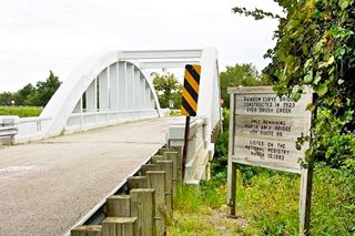
Historic Route 66 Rainbow Marsh Arch Bridge. Marcin Wichary
Click image for St. view
Historic Route 66 segment
Listed in the National Register of Historic Places
Drive south along the "Historic Section" of Route 66 (Bush to Willow Creek), the roadbed is only 25 feet wide and has grassy shoulders. It has the feel of the original 24-foot wide historic highway. The culverts along it date back to 1923.
Field of Dreams
Just 1.7 mi. south of the bridge, to your left, at 8933 SE 50th St. is the "Baxter Springs Field of Dreams baseball and softball complex". It is work of local coach Don Karnes who with his wife and friends organized a non-profit corporation to build the complex on 12 acres of land that the Karnes donated to the project.
Work is ongoing, and there is still a lot to do, but you can see the dream that came true in this St. view.
Site of former DX station
Old Route 66 approaches the north side of Baxter Springs and at 2nd St. it curves east to meet Military Ave. Here, to your right are the foundations of a former DX gas station.
The red arrow marks the concrete base of the old DX signpost.
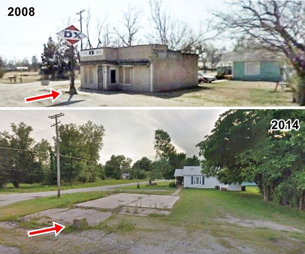
Head along the curve towards Military Ave. at the junction, turn right and head south.
Old Gas Station
On the NW corner of W 5th St. and Military Ave, to your right, you will see a two bay garage service station with a single pump island and no canopy (at least nowadays). It has been restored and is modern garage. It is pictured below.
Site of Fort Blair - Fort Baxter
Continue south and on the next street, to our right is a historic site at Route 66th and 6th St. in the Park
There were some forts in Kansas to protect the settlers further east from raids of hostile Indians. But during the Civil War, they were built to escort military wagon trains through native territories.
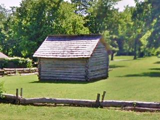
Fort Blair was established in July 1863 and consisted of a block house, log cabins and a wall made of logs covered with rocks and soil. It was the site of the infamous Baxter Springs Massacre. There is a replica of John Baxter's log cabin (pictured above) and Trading Post, and several markers too. A creek runs along its southern flank.
Turn left along E 6th St. to see the log cabin, and south along East Ave. after crossing the stream you will come across the museum.
Baxter Springs Heritage Center & Museum
At 740 East Avenue www.baxterspringsmuseum.org). It several galleries covering the Native American and Civil War periods and the Cow Town and mining eras. Don't miss the Korean War tank or the railroad caboose. The Historic Osage Black Dog Trail opened in 1903 by Chief Black Dog, runs along the museum grounds on the north. Here the Osage camped close to the spring. There is a historic marker on the corner of E. Ave. and E 7th St.
Return to Military Ave (Route 66) and head south for 3 blocks. Here on 10th St. you will find two classic US66 service stations.
Baxter Springs Independent Oil and Gas Service Station
Listed in the National Register of Historic Places in 2003
To your left, at 940 Military Ave - Highway 66, Baxter Springs, KS.
This is a great example of a "Cottage-Style" service station used during the 1920s and 30s as marketing strategies by the major oil companies: homely gas stations that blended in with their urban setting. This soothed the locals and gave a sense of security to the travelers.
It has been restored and now serves as the Kansas Route 66 Visitor Center.

Independent Oil and Gas Service Station. Source
Tudor Revival Style
The style used in these gas stations imitated medieval English cottages; it had simple lines, steep pitched roofs, tall windows, brickwork walls and high chimneys. It turned service stations into "automotive cottages", conveying travelers a warm homey feeling.
The building was enlarged in 1940, but its style was preserved. Originally part of the Independent Oil and Gas Co., it was acquired in 1930 by Phillips Petroleum.
The main features of the cottage style were a pitched and gabled roof, brick and stucco walls, neat windows and a chimney. Notice the bay window by the front door.
Diamond Service Station
Across the road, on the NW corner (Route 66 and W 10 th St.) is another vintage gas station, a former Diamond Gas.
No longer open as a filling station, you can still see its concrete gas pump island and its double bay garage. The curved glass window panes of the office give it an Art Moderne style it dates back to the 1930s, and you can see it below in a "Then and Now" sequence.
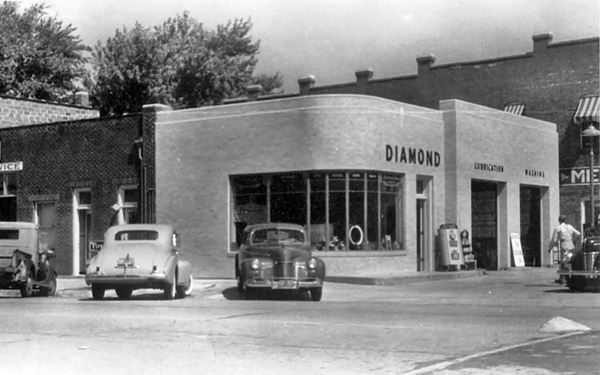
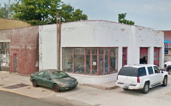
Diamond Petroleum Co. began in Loisville Kentucky, it was acquired in 1925 by Sunray Oil Co. and it became the "D" in "D-X" gasoline and oil brand.
Downtown Baxter Springs sights
Red Brick Buildings from the late 1800s
You are now entering the downtown commercial district with its red-brick buildings from the late 1800s. Here the town's Main Street is, Route 66, and it displays the typical architecture of an American "small town".
Its red-brick faced buildings are remnants of a bustling past, when the street was packed with cars and travelers, during the hey-day of Route-66 when it was "America's Main Street".
Drive one block south, to 11th Street, the place where the following "Then and Now" photo sequence was taken.

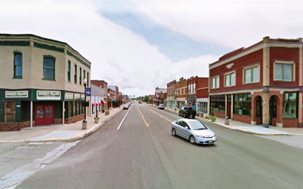
Café on the Route
The building is a Route 66 Roadside Attraction.
On the SW corner of W 11th St. and Route 66 (it is on the right side of both images above), a two-story red-brick building.
The Café, B&B and restaurant closed in 2013 but reopened again in 2018 after it was bought by "Decades of Wheels" which now owns most of that city block and are currently rebuilding it. It servees traditional American Comfort Food with a Twist. It is pictured below
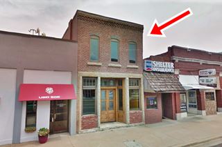
The Café is housed in what used to be the Crowell Bank, built in the early 1870s when the town was going through a boom period based on cattle ranching.
Local lore says that the Bank was robbed in 1876 by Jesse James (1847 - 1882); an outlaw, murderer, bank and train robber.
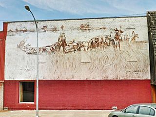
The mural on the north facade was painted by Lis McCool in 1999 (St. view). Facing it, is another mural by John Gibbons, painted in 1991 depicting the "Cow Town" period. Pictured below.
Indiana House
Across Route 66, on the SE corner of E 11th (1145 Military Ave.) is the former hotel. Pictured on the left side of the "Then and Now" sequence further up.
The Indiana Hotel was built here in 1870. The present building was erected in 1900 and over the years it served as a feed store, grocery store and (as in the black and white photo) a clothing store. It has been restored and now it a Real Estate Agency. See its St. view.
Wells-Fargo Station
To the south of Indiana Hotel, at 1112 Military Ave. This building has its original facade and dates back to the 1870s. It housed a feed store, the local newspaper and the Wells Fargo Station. During the Route 66 days, it was McGregor Café and from 1940 to 1982 it was the bus depot for buses traveling along US 66.
Route 66 Soda Fountain Shop
Great neon sign (pictured further up). Just along the block at 1136 Military Ave. It used to be the Oklahoma Tire & Supply Store and later a hardware store. In 2006 it was acquired by a Trust and a Foundation and restored. Now it is a youth center and community educational facility.
The plaque by the door reads "Bill Abernathy Memorial Lifetime Learning Center - Not a Public Facility - This Route 66 soda fountain is devoted to the enrichment and lifetime learning of the citizens of all ages in Cherokee County Kansas. September 2007". A great way to restore and preserve a building and add value to Route 66 and the community.
Across the street are some more "oldies" and "new classic" attractions.
Decades of Wheels

Decades of Wheels neon sign. Source
Starting from the 25-room "Little Brick Inn B&B" at 1105 Military Ave (by the cafe), you will find multiple old store fronts that have become a car museum ("Decades of Wheels"). It has a rotating display of all types of cars from old to modern, chic and comic book. There is an admission fee but its worth the stop.
On the same block is "Spinout Arcade" with bumper cars, pinball, air hockey, and more.
Former Angels on the Route
1143 Military Ave. The building was built in 1865 and served as a Dry Goods Store, over the years it was reformed and became Reedy's Pharmacy in 1910, and Hartley's drug store in 1958. It was a donut shop and in the early 2000s it became a cafe and restaurant. It closed in 2018 and is part of the Decades of Wheels complex. Now it is "Rita's Roost Bistro & Sweetshop" for lunch, dinner and sweet stuff.

The Ritz neon sign lit up. Source
Ritz Theater
1145 Military Ave (NW corner of W12th St and Military Ave.) St. view
The Ritz Theater opened April 30, 1926 (so it is six and a half months older than Route 66).
It closed 30 years later, becoming a restaurant.
Recently it has undergone renovations and reopened as a movie theater, it still shows movies!
US 66 crosses US 166
12th Street is U.S. Route 166 (US 166), running west to east across the city.
It is an original route from the 1926 US Highway system, so it was born together with Route 66.
It is a spur route, and therefore has a three digit number, the last two are the number of its "parent" highway (US 66) and the first digit is the number of the spur.
It is only one of two Route 66 spurs remaining, only US 166 and US 266 survived after US 666 was renumbered as US 491 in 2003 because it was the biblical "mark of the Beast" - read more The Route of the Beast, U.S. 666.

US 66 and US 166 shields
US 166 ran from South Haven to Baxter Springs in Kansas. It was extended to Springfield MO in 1945. Now it ends at I-43's Exit 1 in Missouri.

The Frieze -detail. American Bank. Baxter Springs
Baxter Springs Frieze
Head south, and on the southern wall of the American Bank (SW corner of Military Ave. and 12th St) you can see a unique mural (bank and mural pictured above).
It is a frieze, a brick sculpture by Paula Collier, created in 1995.
It portrays the history of Baxter Springs and includes Route 66's shield.
Head south along Route 66 (westbound), and after 0.5 mi. to your right is an old gas station.
Shouse Gas Station
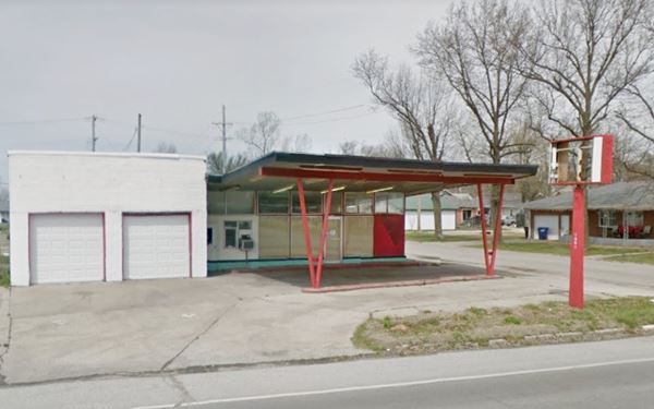
At 1901 Military Ave. This service station was built around 1932, and was known as C. Shouse Service Station.
The original building is on the south side. The one flanking W 19th St. dates back to 1950. It has a more "modern" look to it with a slanted
canopy over the pump island supported by round metal tubes.
Below are three Then and Now pictures of the old gas station.

Shouse Station in 1937

Shouse Station in 1950
Drive south and after crossing E 22nd St. is the site of the former "Capistrano Courts" motel, now there is an ATM in what used to be a garden in the middle of the L-shaped motel. (St. view).
Original Alignment
At 24th St. the highway begins to curve towards the southwest see (blue arrows in map). diverging from the original Route 66 alignment that headed straight south. This roadbed has been removed in this section, but survives south along Roberts Road.

1959 USGS map and later Route 66 alignment
Turn off the main highway by taking a left to take Roberts Rd. (see this Map). This alignment curves too, and both alignments meet ahead, at W 30th and Route 66.
Baxter Modern Cabins were located on the curve, but have gone.
Gas Station on Curve
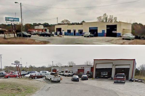
At the southern end of the "S" curves of Route 66 to your left is an old gas station, it has been rebuilt and enlarged quite recently.
Below you can see the older and the newer versions of the station. It had three garages and a central office area, Parapets atop a flat roof, no canopy and a single pump island area.
Now it is a garage (Express Auto Transmission).
Head south for 0.2 miles. Now the road is straight and you will pass beside the now gone Twilite drive in theater.
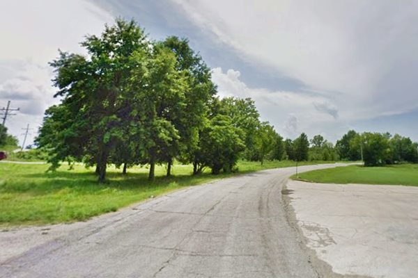
Site of Twilite Drive in
It opened in 1953 and was operated by Louis Stein. In May 1978 a storm blew the screen down and the place closed for good.
You can see the concrete access from Route 66 in the grass next to the highway (red arrows in the image below).


1959 USGS map showing Drive in

Satellite view of Drive in now
This ends your City Tour along Route 66 in Galena.
Just 0.3 mi. ahead is the Kansas-Oklahoma state line. You can do some short tours near Baxter Springs, read on below.
Tours & Itineraries
Spring River
It was named in 1838, and is fed by the crystal clear springs of the area. A cable-ferry boat was built in 1867 and replaced by a bridge in the 1880s. The river turned the turbine water wheels of the Baxter Springs flour mill in the late 1800s, the town's only industry.
Now it is used by campers and fishermen: Kiwanis Park is located to the east of the town, on the north side of E 12 St., next to the River.
Riverside Park on Spring River. On the south side of Highway 166. It has a boat ramp, tables, grills, rest rooms. Camping and RV facilities. Map with Directions.
Tri-State Marker
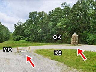
It is set at the point where Missouri, Kansas and Oklahoma meet. It was built in 1938.
A 15.2 mile round trip, see Map. Leave town from Military Ave/Rte.66 and head east along E 12th St.
There is a map on the maker set in the ground and an inscription on a plaque above it detailing how this point's position was established in 1857. The adjacent stone marker was built in 1938 by the National Youth Administration.
National Cemetery
US 166 & 5th St. 2 miles west of Route 66. Map with Directions.
The US government established it, with a soldier's plot where the victims of the Fort Blair Massacre were buried in a common grave in 1870. The names of the 88 men buried there are engraved in the monument.
Spook Lights, the legend
The Tri-state corner area, where Missouri, Kansas and Oklahoma meet is the site of a mysterious phenomenon known under various names: "spook lights", "ghost lights", "Indian lights" and "Hornet lights" (after the town of Hornet, Mo.).
> > Click to read about the Spook Lights on Route 66
Sponsored Content

>> Book your Hotel in Riverton

Credits
Banner image: Hackberry General Store, Hackberry, Arizona by Perla Eichenblat
Baxter Springs Station, Route 66: A Discover Our Shared Heritage Travel Itinerary, National Park Service
City's Chamber of Commerece
Kansas Route 66 Historic District – North Baxter Springs
Kansas Historic Route 66 Corridor Management Plan 2011
Jack DeVere Rittenhouse, (1946). A Guide Book to Highway 66.


