Gateway to Oklahoma
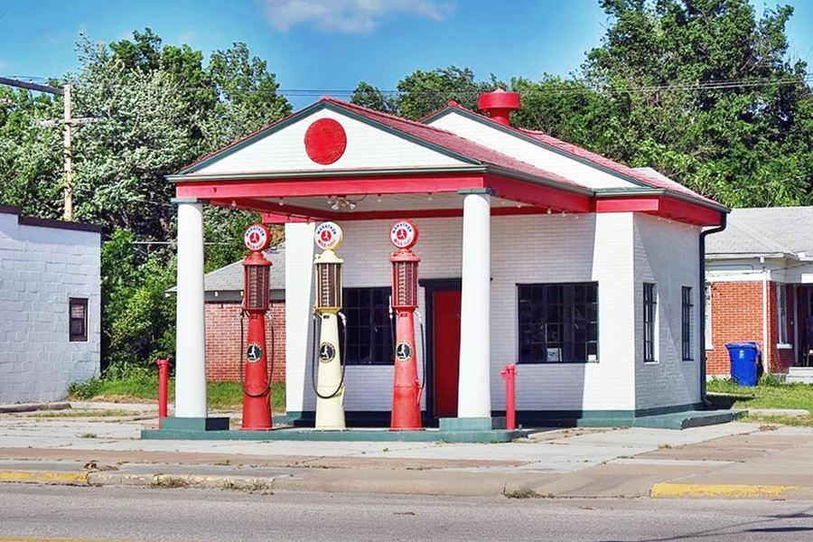
Marathon Oil, a historic gas station from the 1920s
Index to this page
About Miami, Oklahoma
Facts, Trivia and useful information
Elevation: 796 ft. (243 m). Population: 12,806 (2025).
Time zone: Central (CST): UTC minus 6 hours. Summer (DST) CDT (UTC-5).
Miami, pronounced "my-am-uh" is the county seat of Ottawa County, Oklahoma, in the northeastern tip of the state, next to Missouri and Kansas.
As time goes by on Main Street, Miami, looking North (the same block over the years).
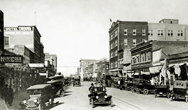
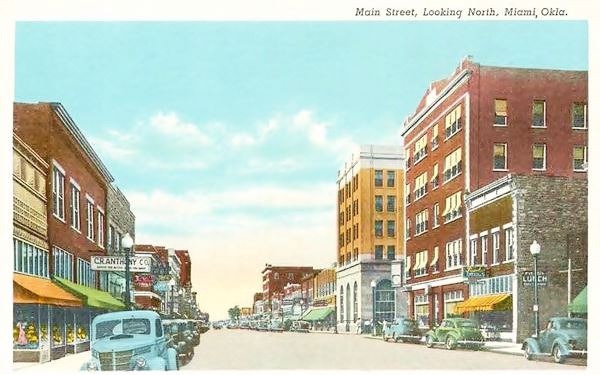
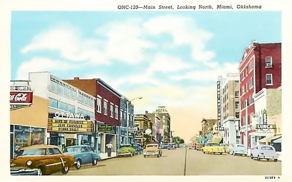
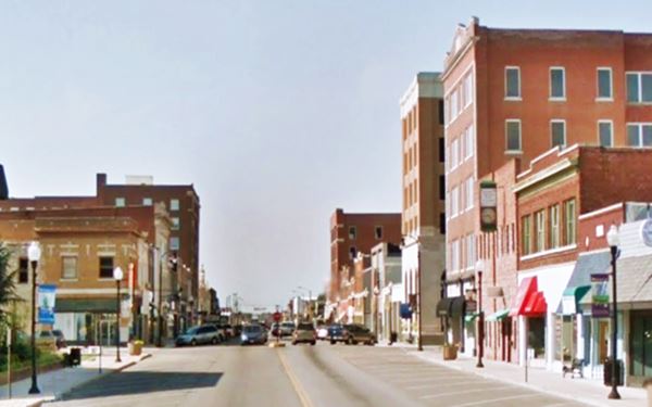
Miami's History
Eastern Oklahoma has been inhabited for over 10,000 years. And the Ossage Indians lived in this area in historic times. The U.S. government acquired the territory from France (Louisiana) in 1803. And set up an Indian Territory (1831) which would be the home of Native Americans relocated from the east of the Mississippi. The project failed, settlers arrived and the land was taken over by the Federal government, railroads and homesteaders.
There was a trading post in the area, and it was known as Jimtown. The post office was established in 1890, by Jim Palmer; he named it Miami after his wife, who was a Miami Indian.
The Miami Tribe and the town's name

Portrait of Mi-A-Qu-A, a Miami chief. Source
Miami in Oklahoma is not related in any way to Miami, Florida. The latter's name is a Calusa Indian word "Mayami", which named the river where the city is located.
The Oklahoma Miami people were first displaced by the bellicose Iroquois to what are now Indiana, western Ohio and southwest Michigan during the 1600s. Then the Europeans advanced into their territory and later the Americans who by the 1826 treaty made them give up their lands. Though many remained in Indiana as citizens, the Miami tribe as a group was relocated during the 1846 "Indian Removal", to Kansas and the Indian Territory in Oklahoma, where they settled.
The natives called themselves "Mayaamia" (in plural: "Myaamiaki"), it is a word in their language, the Miami-Illinois Algonquian. It meant: "downstream people". Another name for themselves was "Mihtohseeniaki" meaning "the people".
So they gave their name to the town, which is also the capital of several tribes: the Miami, the Modoc, the Ottawa, the Peoria and the Shawnee.
An entrepreneur by the name W. C. Lykins embarked on a project to establish a town in the area. So he met with the Native Americans (Ottawa and Miami tribes) and together petitioned the U.S. Congress to allow him to lay out a new town. The project was approved and Lykins purchased 588 acres of land from the Ottawa and auctioned the lots in June 1891. The town was incorporated in 1895.
The same veins of lead and zinc mineral found in neighboring Kansas and Missouri also brought wealth to Miami when ore deposits were found in Quapaw, north of Miami.
The population reached 1,527 in 1900 and grew to around 13,000 in the 1960s, and has remained fairly stable since then.
Ottawa County was created in 1907, when Oklahoma became a state. Its origin was the Cherokee Nation. It was named after the Ottawa Tribe of Indians, and has been home to more Indian tribes than any other county in the U.S. There is a strong Native American component in the local population, as it constitutes 17.1% of the people living in the town.
The town grew with the mining revenue and its downtown buildings were built in the early 1900s. Its economy received a boost when, in 1926, Route 66 was created and its course ran through the town as its Main Street.
Mining wealth and increased travel along Route 66 attracted robbers to Miami during the Great Depression:

Most Wanted, Bonnie and Clyde. FBI
Bonnie & Clyde
The early 1930s were a violent period, and the famous criminal couple "Bonnie and Clyde" was active in this area robbing banks in Joplin, Galena, Baxter Springs, Commerce and Miami.
Bonnie Parker met Clyde Champion Barrow in 1930 and after a rampage of four years they were shot to death in an ambush in Louisiana on May 23, 1934.
They even abandoned a car in Miami during the spectacular manhunt that ended with their death. They had been charged of robbery, kidnapping and 13 murders.
Late 1950s: The interstate relegates Route 66 in Miami
Route 66 became crowded and unsafe so Oklahoma built the Turner and the Will Rogers Turnpikes linking Oklahoma City to Joplin, Missouri in 1957, this multi-lane highway bypassed the old segments of Route 66, the Ottawa county section from Afton to Quapaw drew all the interstate traffic, and reduced the inflow of travelers slowing the local economy.
Today Miami is a charming American "small town" with Route 66 running down its classic Main Street nestled by early 1900s buildings and vintage Service Stations, a short drive from the historic "Ribbon Road" and the "Spook Lights".

Find your Hotel in Miami
There are several hotels in Miami. Alternatively you can also lodge in the neighboring towns in Kansas, Missouri and Oklahoma:
> Book your Hotel Miami
Lodging Nearby in Oklahoma
There are several hotels in the area close to this town. Alternatively you can also find your accommodation along Route 66 in the neighboring towns and cities. We list them below (listed from east to west):
On Route 66's Main alignment
Eastwards
Westwards
>> There are two RV campgrounds in Miami.
Miami’s Weather

Location of Miami on Route 66
Miami Oklahoma has average annual Highs of 70.2°F (21°C), and the lows of 47.2°F (8.4°C) and its mean annual temperature is 58.8°F (14.9°C).
During summer the temperatures average between 92°F and 56°F (33.3 to 13.3 °C) while in winter the range is 48°F to 24°F (8.9 to -4.4°C).
The average Number of Rain Days per year is 84, most rainy months are March through June (with 8 days of rain per month). Yearly rainfall averages 44 inches (1.118 mm), with most rain falling during May, June and Sept. (over 5 inches each of those months - 125 mm).
Snow falls in Miami, with about 11 inches (28 cm) per year between November and March, maximum snowfall has been 23 in. in one month (58 cm).
Tornado Risk. Miami is in the Oklahoma "Tornado Alley and experiences about 9 Tornado watches every year. Read more about: Tornadoes on Route66.
Map of Route 66 in Miami
See the description of this segment in our KS-OK state line to Vinita webpage.
The interactive map below shows the alignment:
map of this segment in Miami.
Map with the alignment of Route 66 through Miami
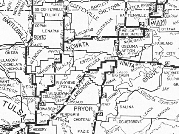
The map below was published in 1924, two years before Route 66 was established. It shows the grid of "Auto Trails" in NE Oklahoma. Miami is in the upper right corner and what would become Route 66 is marked as "50", meaning the "Ozark Trails", you can follow it from Baxter Springs KS all the way to Tulsa OK. The Ribbon Road or Nine-Foot-wide-road is shown from Miami to Narcissa.
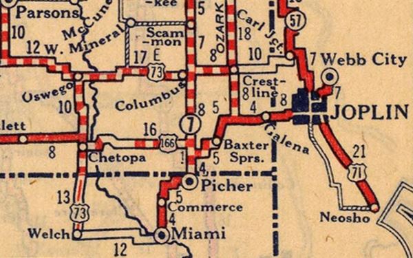
The following map from 1927 was published one year after US 66 was created, it shows Route 66 paved from Picher to Miami. What is interesting is that west of Baxter Springs Kansas, the alignment differs from the one recorded in most official descriptions. Instead of heading south into Oklahoma through Quapaw and then Commerce, it heads west and then south into Oklahoma through Picher!
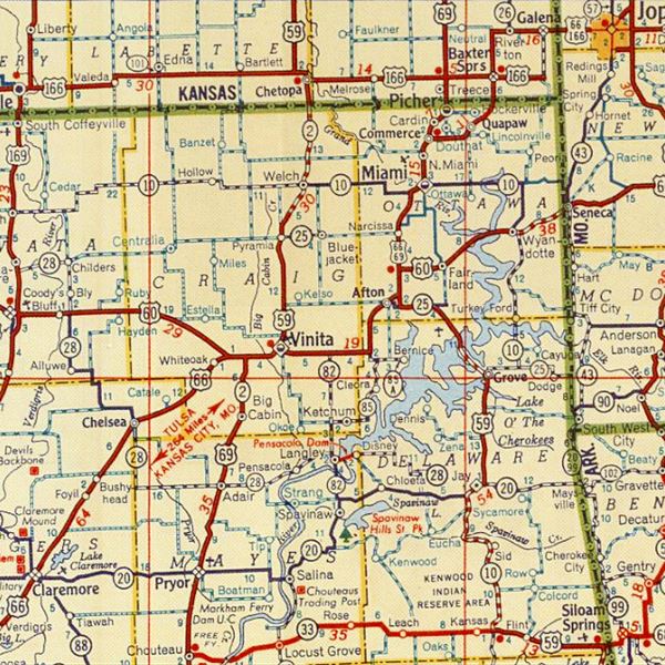
1948 Shell Roadmap northeast Oklahoma
Click on map to enlarge
Source
The thumbnail map (click it to enlarge) was published in 1948. Before the interstate was built. It is a Shell Highway Map and it shows northeastern Oklahoma and SE Kansas. You can follow Route 66 from the upper right (Galena KS) to Claremore OK on the lower left. Miami is in on the upper right side.
Check out Miami on our Map of Route 66 in Oklahoma, which has the complete alignment of the Mother Road across the state and all the towns along it. You can also see this map with US 66 alignment in Miami.
Route 66 Alignment near Miami
Visit our pages with old maps and plenty of information of the old US 66 roadway.
- Vinita to Tulsa (next)
- KS-OK state line to Vinita (Miami's)
- Ribbon Road or Sidewalk Road. (original road)
- Route 66 in Kansas (previous)
Route 66 landmarks & attractions in Miami
- City Tour of Miami (read on below)
- Tours & Itineraries
- State Parks
Miami a drive through the city
In 1946 Jack DeVere Rittenhouse drove US 66 and published his "A Guide Book to Highway 66" which tells us how the highway was during its golden days. He mentioned Miami.
Pop. 8,345; alt. 800': major hotel: Miami, also Main Hotel; garages: Neosho, B. & M., Norton-Elliott, Miami; tourist court: Sooner State; stores; all facilities. Rittenhouse (1946)
Rittenhouse also mentioned that two miles north of the town was "North Miami... courts: Butler's, Miami, O'Brien's and O'Connors Trailer Park... really a suburb of Miami".
These motels have all gone, only the old Miami Hotel and Main Hotel have survived, but there are other Route 66 classics not mentioned by Rittenhouse that are worth seeing. We will start our tour coming from Commerce, on the north side of the city and head west along US 66. On the 900 block of North Main Street to your right is an great 1950s neon sign.
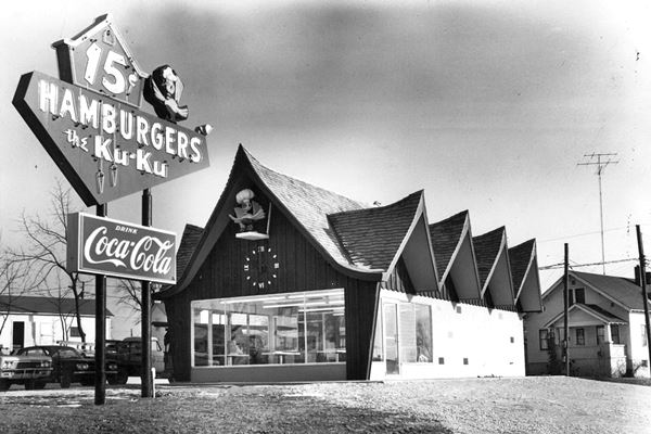
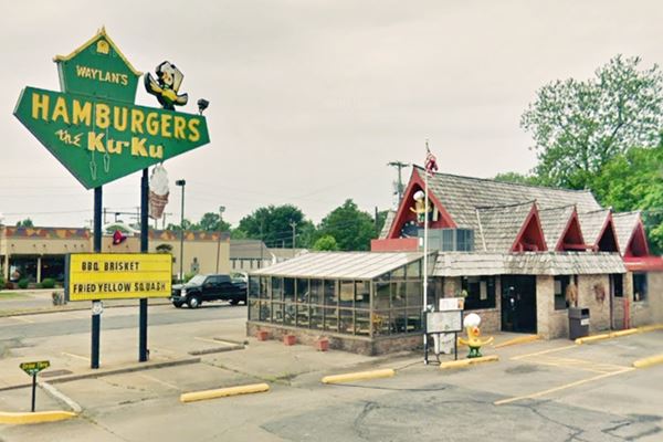
Waylan's Hamburgers the Ku-Ku
At 915 N Main St. Miami. It is the last remaining store of what once was a drive-in chain with 200 stores. Ku-Ku went broke in 1969. Eugene Wylan bought the Miami location in 1973 and renamed it "Wylan's Ku-Ku", and has been feeding travelers for decades. Don't miss its classic yellow-green neon sign (built in 1965) or the fiberglass cuckoo bird on its front wall.
Below is a Then and Now sequence. The ice-cream cone was added in 1977, and Wylan's name in the cukoo house replaced the old ¢15 cost of a hamburger that same year.
A US 66 gas station
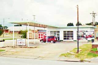
To your right, at 510 N Main
It has a long flat canopy with a slight slant, over two pump islands. It is supported by four steel poles. The and a glassed office with a single entrance transom door next to a two-door garage (multiple pane glass doors). Possibly a Conoco.
Route 66 across downtown
Route 66 originally crossed town along Main Street, but as the flow of traffic increased, in 1968 it was split into two different routes, one, westbound along A Street NW- and A SW, heading west and another along A St. SE and NE that carried the eastbound traffic.
Map of US 66 towards the west (Now US 69 South),
Map of US 66 towards the east.
Take a right from the gas station, following current US 69 South along Circle Dr. NW and then a left along A St. NW heading south.
Ice Box gas station
498 A St. NW, here on the SE corner is a tiny box-shaped replica of a filling station it even nas a concrete pump island; well done.
Return to Main St. along 5th Ave and turn right, head into town. The Car dealership building at 429 N Main St was at one time service station too (Street view).
Continue southbound, to 1st Ave and see the "Historic Coleman Theater" on the northeast corner of Main and 1st.
Historic Coleman Theatre
Listed in the National Register of Historic Places
103 N. Main St., Miami, OK.
Historic Coleman Theatre, Miami
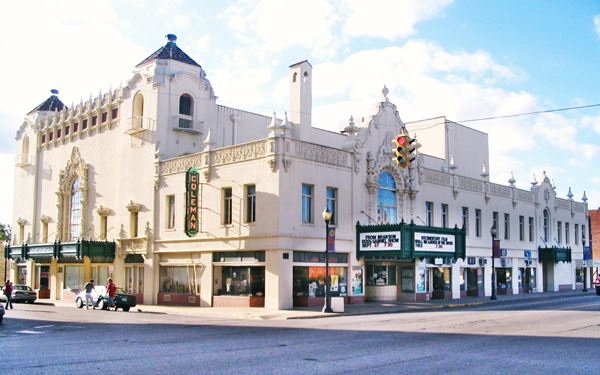
A lavish Spanish Revival style building, built in 1929 with luxurious decor, to provide entertainment to those travelling along US 66.

Coleman Theater in 1929. Source"
The local millionaire George L. Coleman Sr. conceived the idea and provided the funds to build it. He commissioned the Broller Bros. from Kansas City to design it with grandeur. The theatre can seat 1,600 people and cost $600,000 to build, a small fortune in those days ($9.5 million nowadays).
Its interior has Louis XV decor, including a chandelier, winding mahogany staircases, statues, gold leaf trim, and silk panels. Its facade has terracotta ornaments, carvings and even bell towers with balconettes. A typical example of Spanish Revival style.
The theatre had a pipe organ (the "Mighty Wurlitzer") and offered the local customers and travelers movies, vaudeville and live music. It was refurbished and renovated and is open, as a commercial and entertainment center. There are free tours too; visit the website: www.colemantheatre.org.
Hotel Miami
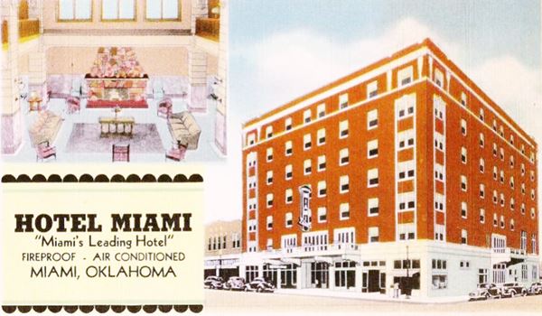
Facing the theater, on the SW corner. This hotel was mentioned by Rittenhouse in 1946, it towers with 7 stories above Main St., with a red-brick facade.
Its advertising in the 1930s tells us: "Fireproof - Air Conditioned - 150 Rooms --- $1.50 and Up. Free Parking Space For Our Guests - Center of World's Greatest Lead and Zinc Mines."
It was built in 1917-18 and nowadays is the "Miami Towers", it is owned by the Miami Housing Authority.
Continue your tour along Main St., on the south end of the block, turn right along W Central Ave to visit a 1930s gas station.
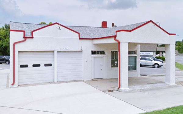
Vintage Gas Station (Sinclair? Magnolia?)
7 A St. on the NW corner with W Central Ave. The gas station has two garage bays, one pump island. Pedimented parapets, single-door entrance with multi-light transom. Its building and canopy are gabled, a style favored in the 1930 to 1940 period.
Don't miss the great Art Deco building facing it across W Central. Retrace your steps, head east, cross Main St. This area is the Historic District.
Miami Downtown Historic District
Main St. and SE A St. at Central Avenue. Just one block to the east is the Commercial and business district of Miami which comprises 29 buildings along the Main Street and the side streets in the downtown district. They were built between 1902 and 1958.
There are some Art Decó styled buildings. Unfortunately many were demolished in the mid-1960s to create parking space.

Main Hotel nowadays. Click for St. view. Source
St. James - Holvey's Main Hotel
Listed in the National Register of Historic Places
One block east of Main St., on the NE corner of SE A St. is this building erected in 1917-19 as the Commerce Building. It was George Holvey's Main Hotel (mentioned by Rittenhouse) and later became St. James Courts.
Head back to Main St. and turn left, head south to visit the "Gateway".
Miami "Gateway" Portico
211 S Main St., between 2nd and 3rd streets, straddling Route 66. As part of the city's project to reinforce its Route 66 roots, a replica of the classic steel structure was planned in 2007. It was built and finally erected by Heck and Wicker Inc. in July 2012.
The new steel structure with a triangular top, proclaims to all visitors "The Gateway, Miami, Okla."
Looking north along Main Street (US 66) in Miami Oklahoma.
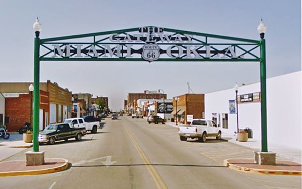

Original Gateway in Miami, Source
Oklahoma Marker by Gateway
Don't miss the Historic marker to your left, on the eastern side of the structure. It says: "Gateway Sign - A replica of a sign originally constructed in the 1900's that spanned Central and C Street adjacent to the railroad station. For many years this sign welcomed visitors to downtown Miami. The original sign was removed in the 1930s. Today's replica welcomes visitors to a revitalized downtown Miami.". It has a picture of the old sign (see image).
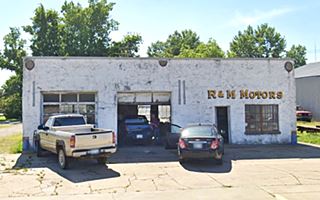
Old Gas Station R and M Motors
On the western side of the gateway you will see an old garage, which looks like a former gas station. Oblong box layout, with two garage bays, flat roof and an office on the north side. No indication of which brand it sold. It is pictured below, now R & M Motors.
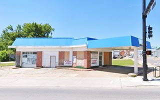
Corner Gas Station
Just ahead is 3rd Ave, this is where, after 1937, U.S. 66 traffic turned right towards the Neosho River along 3rd Ave. and left the town westwards.
NW corner of Main and 3rd Ave. Strategically located, this gas station has two garage bays facing south and a pump island under a flat canopy on the corner. Its facade includes brickwork and a faux-roof with sloped panels along the building's cornice. Pictured above.
The two alignments of Route 66 on the south side of Miami
1. Old 1926-37 Route 66 Alignment
The original Route 66 alignment, laid down in 1926, didn't turn on 3rd Ave, instead it continued straight southwards along Main Street and became the Ribbon Road or Sidewalk Road. This is the 1926 alignment map of US 66 in Miami.
You can drive this alignment which meets the later one, 6.4 miles southwest of this point.
2. The 1937-1985 US 66
This one heads west, along E 3rd Ave., crossing the Neosho River and then curving southwards. There is an old historic motel on this alignment. It meets the early alignment 5.2 mi. SW of this point. (1937-85 alignment map South of Miami.
First we will follow the later alignment and visit the motel. Then we will drive the Ribbon Road.
West along the 1937-1985 US 66
Head west along E 3rd Ave amd after crossing the Neosho River, at the curve, to your right, you will see a "Historic Route 66 motel".
Riviera Courts
One mile southwest of Miami, by the curve on U.S. 69A.
Listed in the National Register of Historic Places
Motor Courts improved on the concept of tourist camps and cabins as they united the lodging units under one roof, with a V or U shaped arrangement. They are predecessors of Motels.
This Court was built in 1937 on a highly visible location on the western access into Miami.
The lodging units were painted white and joined under one roofline, in a single story brick structure, and were separated by garages. It had a "V" shape.
It was owned and operated by Adam Ried and his wife, boasted facilities with "All brick modern 100%, fire proof, automatic steam heat. Tile showers, beauty rest mattresses, cross ventilation and ventilating fans".
The Will Rogers Turnpike opened in 1957 and traffic dwindled. In the late 1950s it changed its name to "Holiday Motel" and gradually faded away until it closed in 1978. Today it lies in disrepair. Below is a "Then and Now" sequence, the red arrow marks the administration and office, the blue arrow the southern wing of the complex, seen from Route 66.
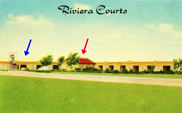
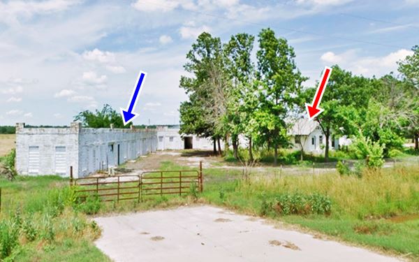
South along the Original 1926 Route 66 Alignment
Retrace your steps back to Main Street, take a right along it, head south. This is the 1926 alignment, and to your left on the next corner, at 4th Ave. is a Historic Marathon Oil Gas Station.
Miami Marathon Oil Company Service Station
Listed in the National Register of Historic Places.
331 South Main St., Miami, OK.
A unique 1929 service station on Miami's Main Street. Pictured at the top of this page.
Historic Miami Marathon Oil Company Service Station (before the vintage pumps were installed)
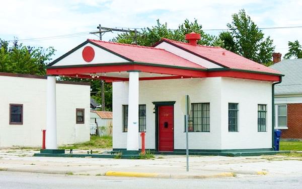
The service station was built in 1929 by the Transcontinental Oil Co. The company was later acquired by Marathon Oil (which is still in business today) and the service station adopted the new owner's logo.

Old Marathon Oil logo, Jon R. Roma
The logo depicted the Greek runner who conveyed the news of the victory of Greek forces over the Persian invaders at Marathon. His name was Pheidippides, and he ran all the way from Marathon to Athens (26 miles - 42 km), gave the good news and, according to legend, fell dead on the spot.
Marathon Oil's slogan was "Best in the long run" fitting to its name.
The building has a Neoclassical Revival style. Its canopy and sturdy classic columns resemble a Greek Temple (again, matching its name). The canopy provided shade to motorists and the gabled roof gave it a homey residential look reassuring to motorists, which was favored in the 1930s as it allowed the building to blend in with the surrounding residential area.
Its design and location, on a corner, gave it good exposure to traffic flowing down Main St. during the first decade of Route 66's existence.
Head south along Main St., cross the Neosho River along the bridge built in 1967 and continue now along E SW Rd. pass the Miami Fairgrounds. At E 130 Rd. follow the curve and head west. This is the "Ribbon Road".
The Ribbon Road or Nine-Foot-Section of Route 66
Listed in the National Register of Historic Places
Between Miami and Afton is a very old segment of Route 66. It predates the creation of the highway as it was completed between 1921 and 1922, over four years before the creation of Route 66. Actually Route66 was aligned along this pre-existing road when it was commissioned in 1926.
The "Ribbon Road" in Miami, OK.

by Jimmy Emerson, DVM
The original Route 66 was pieced together linking different State highways, and these roads had different surfaces, paving and even widths.
The famous "Sidewalk road" or "Ribbon Road" is a very narrow section of the Mother Road. It was used between 1921 and 1937 when it was replaced by a shorter and, even more important, wider stretch of road (current U.S. 69) between Miami and Afton.
This section has a paved surface that is only 9 feet wide (2.75 m), flanked by two five-foot gravel shoulders.
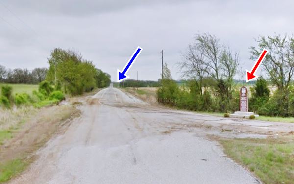
The road has sharp 90° curves and can still be driven along. It has been resurfaced but is still operational. There is a marker near Narcissa next 140 Rd. and U.S. 69 detailing its history. Map showing where marker is.
View of the Marker (red arrow) and the Historic Ribbon road (blue arrow) at the point where it meets the 1937 alignment.
> > Learn more about the Route 66: The Ribbon Road
This ends your city tour of Miami along Route 66.
Tours & Itineraries
Spook Lights, the legend
The Tri-state corner area, where Missouri, Kansas and Oklahoma meet is the site of a mysterious phenomenon known under various names: "spook lights", "ghost lights", "Indian lights" and "Hornet lights" (after the town of Hornet, Mo.).
It consists of a strange light appearing, dimming and brightening, jumping about in the air, moving and then disappearing. It is said to date back to the days of the Indians, and many explanations have been offered: marsh gas, plasma, magnetism, ghosts and even the lights of cars on the old Route 66 refracting in the layers of warm air....
A short film, of the "Cars" series by Pixar ⁄ Disney, "Mater and the Ghostlight", was inspired by these mysterious lights...
>> Read more about the Spook Lights on Route 66
Is Route 66 haunted? Learn about its ghosts, phantoms, and spooky places.
Natural Attractions
National & State Parks
Miami, Oklahoma, has great landscapes and nearby places ideal for outdoor recreation and enjoying nature, there are several areas nearby along the Grand Lake State Park:
Grand Lake State Park
The Grand Lake O' The Cherokees has a surface area of 45,000 acres and boasts 1,300 miles of coastline. The park is known as the "Crappie Capital of the World" and is ideal for swimming, walking and enjoying water activities.
Twin Bridges Area
Located 11.2 miles southwest of Miami (Hwy 137 and U.S.60, Twin Bridges Area: 14801 S Hwy 137. Fairland, OK. Map with directions.
It is a great fishing area in a quite country setting. The area has campground, RV park and picnic facilities.
Read more at the official website.
Berenice Area
2 1mi. South of Miami, at 54101 E Hwy 85 A, 1⁄2 mile east of Berenice, OK. Map with directions.
Enjoy the picnic areas, swimming beach, wildlife watch towers, RV park and campground.
Read more at the official website.
Sponsored Content

>> Book your Hotel in Vinita

Credits
Banner image: Hackberry General Store, Hackberry, Arizona by Perla Eichenblat
Jack DeVere Rittenhouse, (1946). A Guide Book to Highway 66
Miami Marathon Oil Company Service Station; National Park Service
Oklahoma, Miami Nine-Foot Section, National Park Service.


