Mining Town on Route 66
Index to this page
About Commerce, Oklahoma
Facts, Trivia and useful information
Elevation: 810 ft. (247 m). Population: 2,268 (2025).
Time zone: Central (CST): UTC minus 6 hours. Summer (DST) CDT (UTC-5).
A small town located just north of Miami, in the northeastern corner Oklahoma, in the Kansas - Oklahoma - Missouri "Tri-state" region.
Commerce, looking north along Main Street - Route 66: Dairy King and the Conoco Gas Station.
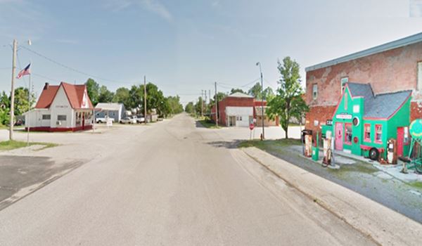
On the left: Dairy King, on the right: Conoco Hole in the Wall Service Station. Click image for Street View
The History of Commerce
Visit our Miami, History webpage for full information on the region's history.
In the days when Oklahoma was a Territory, prior to becoming a State, this area was peopled by the Quapaw Indians and managed by the Quapaw Indian Agency. These natives had been relocated to Oklahoma after being displaced from their homeland in Arkansas in the 1830s.
The Quapaw
The treaty of 1867 assigned them a piece of land in the northeastern corner of what is now Oklahoma. They moved to the Osage land in 1877 but returned in 1893 to their own territory. There they received the land between the border of Missouri, Kansas and the Neosho River (over 56,000 acres) which they divided among the tribe members.
White settlers soon entered the region attracted by its mineral wealth. What would become Commerce was originally a mining camp which formed there in 1906. Its first name was Hattonville, a name which it took from Amos Hatton, a mining developer who had started zinc and lead extraction at the Emma Gordon mine.


The images above show ➀ a now gone Phillips 66 gas station, ➁ the Star Cash Grocery, that was open from 1938 to 2011, and only sold cash. The old Coca Cola sign has survived. ➂ Commerce Motor Co. whose building deeply altered, is still standing.
Commerce, the name
Four experienced prospectors and miners J. F. Robinson, Charles Harvey, George W. and A. E. Coleman explored the northern region of what is now Ottawa County in 1905. They sunk several holes and found rich ore which would later become the "Old Chief" mine.
They formed the Commerce Mining and Royalty Company, one of the most successful mining companies in the region. It gave its name to the town it platted in 1914.
As the mining industry grew, a railroad was built to link it to Miami (1908). A post office was established in 1913, and it was named "North Miami".
The mine was acquired by the Commerce Mining and Royalty Company and the post office soon adopted the name "Commerce".
Shortly after that, the mining company laid out a town (June 1914) which was named after it. A municipal government was established in 1916. The population grew considerably.
Route 66 was created in 1926 and it passed through Commerce on its way to Miami. This brought prosperity and also thieves:

Most Wanted, Bonnie and Clyde. FBI
Bonnie & Clyde
The early 1930s were violent years: gangsters and bank robbers were very active, and one famous criminal couple, "Bonnie and Clyde", robbed several banks in the Tri-State region between Joplin, Commerce and Miami.
Bonnie Parker met Clyde Champion Barrow in 1930 and after a violent rampage of four years they were shot to death in an ambush in Louisiana on May 23, 1934.
Their downfall began in April 1934, in Commerce. The fugitive couple and Henry Methvin got stuck in a muddy ditch near Commerce. Someone who passed by them saw that they carried guns and notified the police at Commerce. The local Chief of Police, Percy Boyd and the Constable William Calvin "Cal" Campbell drove to the spot and as they approached the car, they were received by a barrage of bullets fired by the fugitives.
They killed Campbell and wounded Chief Boyd who was kidnapped. Boyd was released the next day, at Fort Scott, Kansas, 70 miles north of Commerce.
Campbell, a widower was buried in Miami cemetery by his wife, where you can visit his grave. There is a Memorial honoring him in Commerce's park.
The manhunt began immediately and it ended with Bonnie and Clyde's death in Louisiana. They had been charged of robbery, kidnapping and 13 murders.
End of Mining and Route 66
The minerals became exhausted and mines closed down in the 1960s. At the same time Route 66 had become unsafe and overcrowded. New highways were built to replace it: the multi-lane Turner and the Will Rogers Turnpikes linked Oklahoma City and Joplin, Missouri in 1957 and this bypassed the old Route 66, in Ottawa County.
Business decreased and residents turned to farming and ranching. Population dwindled.
Getting to Commerce
It is 5 miles north of Miami (which, in turn, is the first major town in Oklahoma coming from Kansas). It is 10 miles south of the Kansas state line and Baxter Springs, KS.
To the south, along US 69 - Route 66 are Narcissa and Afton.

Hotels in Commerce
There is no lodging in Commerce, but there are several hotels in neighboring Miami. Alternatively you can also find accommodation in the neighboring US 66 towns in Kansas, Missouri and Oklahoma.
> > Book your hotel 5 mi away, in Miami
More Accommodation along Route 66
There are several hotels in the area close to this town. Alternatively you can also find your accommodation along Route 66 in the neighboring towns and cities. We list them below (listed from east to west):
On Route 66's Main alignment
Eastwards
Westwards
>> There are two RV campgrounds close to Commerce.
Commerce’s Weather

Location of Commerce on Route 66
Check the Weather and climate of Miami - Commerce for historical weather information.
Tornado Risk: Commerce is located within the Oklahoma "Tornado Alley and experiences around nine Tornado watches every year.
Read more about: Tornados on Route-66.
Map of Route 66 in Commerce
See the description of this segment in our KS-OK state line to Vinita webpage.
The interactive map below shows the alignment:
map of this segment in Commerce.
Maps showing the alignment of US Highway 66 through Commerce
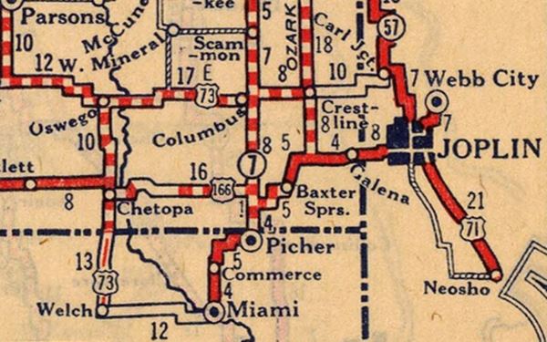
The following map was published in 1924, and shows the "Auto Trails" in northeastern Oklahoma. Commerce is on the lower left side. The trails marked (2), Jefferson Highway and (50), Ozark Trail converged there.
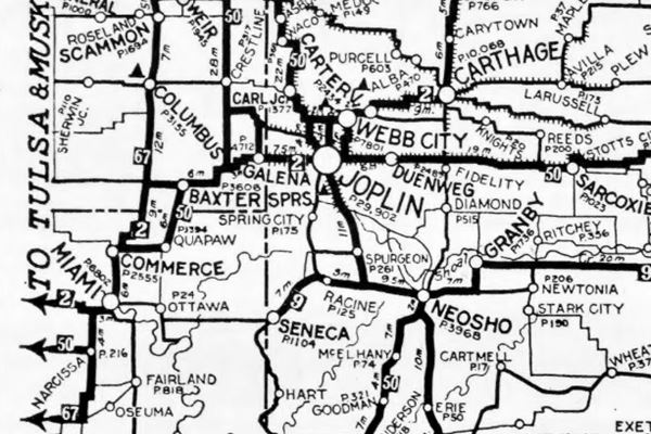

1927 Map Federal Aid Highways, Large size map
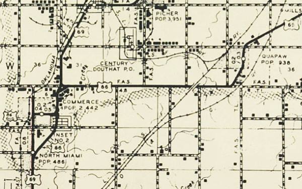
The other map published in 1927, shows the highways built under the 1921 Federal Aid Highway System. The letters "A", "C" and "E" indicate the type of paving used on the highways.
The surprising part is that
there is no highway linking Commerce with Quapaw instead it runs north through Picher. South of Miami the Ribbon Road or Sidewalk Road can be seen all the way to Narcissa.
This can also be seen in the following map, published in 1927, one year after US 66 was created. It shows Route 66 paved between Picher and Miami, bypassing Quapaw!
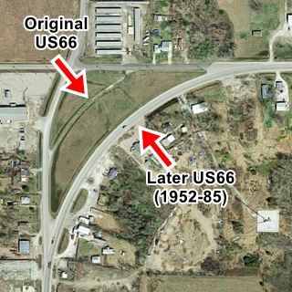
The original 1926 to 1952 Route 66 ran through Commerce 1926-52 US 66 map. Then, in 1952 it was routed to bypass the town 1952-85 US 66 map. The following map from the early 1950s shows the new bypass, and the original alignment renamed as BYP 66. Notice how US 69 had a different alignment to its present one, forking from US66 on the north side of Commerce. Now it does so further east.
Check out Commerce on our Map of Route 66 in Oklahoma, which has the complete alignment of the Mother Road across the state and all the towns along it.
Route 66 Alignment near Commerce
Visit our pages with old maps and plenty of information of the old US 66 roadway.
- Vinita to Tulsa (next)
- KS-OK state line to Vinita (Commerce's)
- Ribbon Road or Sidewalk Road (original road)
- Route 66 in Kansas (previous)
Route 66 landmarks & attractions in Commerce
Sights in Commerce
- In Commerce: read on below
- Tours & Itineraries
Commerce a Route 66 City Tour
Historic Context: US 66 in 1946
In 1946 Jack DeVere Rittenhouse drove along the whole of Route 66 and published "A Guide Book to Highway 66". It gives us a good idea of what it was like to drive the Mother Road at that time. He mentioned Commerce.
US 66 turns south. At the curve is a roadside park with tables and fireplaces... COMMERCE (Pop. 2,422; alt. 805'; only tourist court is O'Brien's Camp on north side of town; Lee Sult's garage; gas; limited facilities.)... a town composed chiefly of homes of miners, whose cottages and shacks are mingled among the many chat heaps [mine tailings ]. In the town, where US66 makes a sharp turn, is a large mineral specimen shop, selling samples of native and other ores for 10¢ and up. Rittenhouse (1946)
We will start our drive through town on the Northeastern side of Commerce, where Route 66 and US69 which have an east-west direction, curve south. This is the site of Rittenhouse's roadside park.
US66 roadside park
Bound on the north by E 50 Rd., on the east by US 69 (N Park Circle) and on the west by N Mickey Mantle Blvd. it is roughly triangular. The original Route 66 alignment cuts an arch across the western side of the park and can be clearly seen from its northern and western sides. Only in 1952 would the present alignment (now US69) be built to the east of the older one. US 69 originally continued north along Mickey Mantle Blvd and 560 Rd. to Picher.
There is a marker in a stone monument on E 50Rd., on the northern tip of the old alignment.
Worley's DX Station
Ahead, after the park and the curve as US66 straightens and takes a north to south course, to your right is a former gas station (602 N Mickey Mantle Blvd).
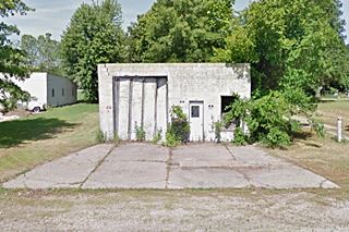
It used to be a D-X gas station, owned by Worley. The old oblong box building is now a home.
Yet the pump island is still there, in front of the building, with a bush growing right in the middle of it.
In the 1960s vintage image you can see the garage bay, which now is the
home's garage, the now gone canopy, and the pumps and island where the bush is now growing.

1960s photo of Worley's Source
Site of Ernie Pyles Cosden station
Continue driving south. At the intesection of 3rd St. and Route 66, to left on the eastern side of the highway are the remains of "Ernie Pyles Station", you can make out the concrete foundations of the building and the pump island in the grass (Street view).
Its advertising from 1963 states "For Corteous Cosden Services its ERNIE PYLE Service Station and Radiator Shop. 300 N Jefferson... Highways 66 & 69."
Commerce Diner
Across the street, on the SW corner of 3rd and Route 66 (215 N Mickey Mantle) is what once was a Diner, built in 1954. Deeply modified, it is still standing.
Andy's Cafe
Head south and as you turn right to drive along Commerce St. (Route 66's 1926-52 alignment), on the SW corner is another spot to eat at.
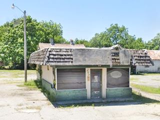
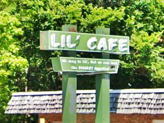
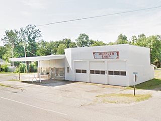
Now selling Mexican food, it dates back to 1953. Its advertising in 1963 said "For Good Eats - It's Andy's Cafe. Menus Changed Daily. 6 AM to 10 PM Daily. Closed Sundays". Before turning into Commerce St. Visit the only two remaining landmark on the 1952-85 alignment of Route 66 in Commerce, the old "Mullen's station and rock store" an "Lil' Cafe".

1960s photo of Mullen's Source
Mullen's Service Station and Rock Shop
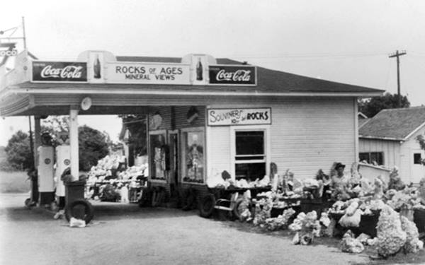
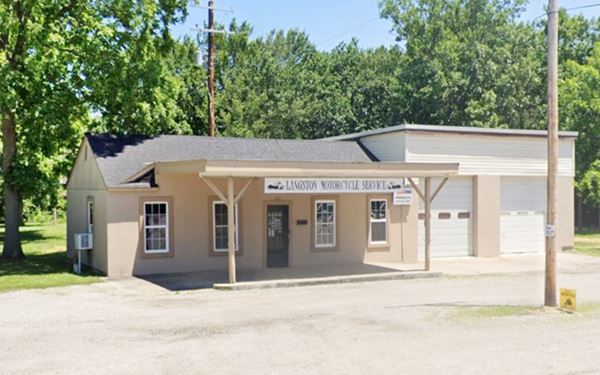
Just one block south, to your left (203 S Mickey Mantle Blvd), now the old station is Langston Motorcycle service. The building is very similar to the one shown in the images below. It has a canopy over the pump island, a two bay garage and a gabled roof.
Jim Mullen began his rock collection in 1934 and gathered many specimens himself from the tri-state-area mines and caverns. He bought D.E. Dion's shop and service station ("Rocks of Ages") on Route 66.
The timber truss at the top of the post supporting the canopy can be seen in the 1960s picture (upper right) and the current street view.
In the "Rocks of Ages" picture below you will see that there are no garage bays to the right. These were a later addition. It was a Phillips 66 station.
Lil' Cafe
On the next block, also to your left. Opened in 1989, great neon sign their motto written on it "We may be lil'. But we can feed the BIGGEST Appetite!".
Now turn around, and take Commerce St. (to your left) and drive into the downtown district of Commerce. This is the 1926-52 Route 66 alignment.
Turner's Apco service station
To your left at 704 Commerce St. is the 1950s Turner's Apco Service station, you can make out its three garage bays, canopy over the pump island and office with a stone facade.
APCO stood for the Anderson-Prichard Oil Corporation, founded in 1922. It became APCO in 1960 and sold gasoline in the Oklahoma region until it was dissolved in 1979.
Basil's Cafe (Razed)
Ahead on the NE corner of Cherry and Commerce, to your right was a former restaurant. "Basil's Cafe" opened in the mid 1940s that was ran by Basil Baker well known for its chicken fried steak. In the 1970s it became "Bar H" was owned by Wayne and Joanne Holden. Recently razed.
Finally the road meets Main St., and here you will see the two main Route 66 sights in Commerce.
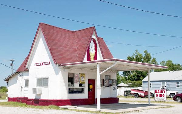
Dairy King
Former Marathon - Tydol - Broyles station

Marathon Oil gas station ca.1930. Source
100 N Main St. Commerce. Located on the west side of Main Street, just across the road from the "Hole in the Wall" gas station.
It is a good example of a building that has been restored and converted to a new purpose while preserving its historical Route 66 vintage appearance.
In the past it sold gasoline of Marathon Gas company, and was also a Tydol station. Its style is that of a cottage. The current building has a red gabled roof and a flat canopy on the front of the building. A large neon light ice cream cone decorates the front sector under its roof.
It sells ice cream burgers and Route 66-shaped cookies.
The Dairy King Ice Cream Café former Browles' gas station.
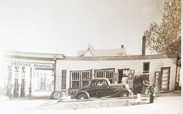
The image below shows Landon Broyles' gas station. In the background you can see the steep gabled roof of what is now the Dairy King. In fact Broyles' station had two buildings, the cottage (which has survived as Dairy King) on the south side, and the building shown in the image, on the north side. Both had gas pumps as you can see, but the north one was the garage and tire repair area. The gas brand Tydol existed between 1920 and 1956. Kelly Tires, formed in 1894, became a part of Goodyear in 1932 and is still making custom tires.
Vintage photo of Broyles' gas station (now Dairy King) on Main St. and Commerce St. (US66), Commerce.
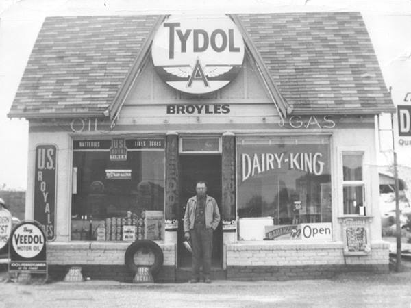
Below is another view of the gas station, showing the southern building, the "cottage" (now the Dairy King), notice the gas pumps reflected in the window on the left. The Tydol "Flying A" logo sign is above the entrance.
Another photo of Broyles' Tydol gas station (notice the Dairy King writtn on the right window), Commerce.
Hole in the Wall Conoco Station
F. D. Mitchell Station
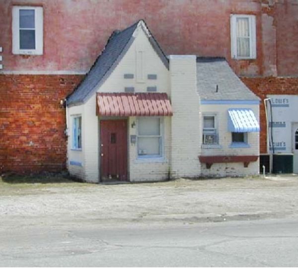
101 South Main, on the SE corner of Commerce St. facing the Dairy King, on a narrow and long plot of land. The image below shows the southeastern corner of Main and Commerce streets. The building with the "Ford" advertising sign painted on it was torn down, and the Conoco station was built there. The building next to it, on Commerce St., marked with the red arrow, is still standing. The 1920s picture shows the curved paved road which would become Route 66 in 1926, turning into Commerce from South Main (right).
This is a genuine relic of Route 66, a service station that was built right onto a brick wall in the late 1920s. Now known as "Allen's Conoco Fillin' Station".
The corner of Main and Commerce streets, Commerce. In the 1920s and nowadays
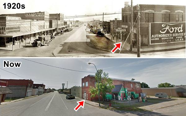
It was built between 1929 and 1930 by F. D. Mitchell. Robert and Linda Allen bought it in 2007, refurbished it and turned it into a shop that sold Route 66 memorabilia and souvenirs. It was a Phillips 66 station in 1938 and was later the White Castle Beauty Shop.
After Linda's death, Bobby Allen put it up for sale (2020).
Gas Station's Design
It is another example of the original generation of gasoline stations that were designed to look like homes, with a cottage style. They were cute and homely, to reassure travelers and make them feel secure and at home.

F.D. Mitchell's ⁄ Allen's Conoco Route 66, Source. Click for st. view
As a Phillips 66, it is atypical as it has an odd type of "cross gable" roof, which is "L" shaped, and the southern half of it is a pent-roof, meaning it only has one slope to it.
The slope of the roof is slightly concave instead of being a flat surface. Phillips 66 stations were gabled, but "T" shaped. The entry door was set under an archway beneath the front-facing gable (the "leg" of the "T"). This station lacks an archway, and its door in the front of the "L".
Conoco on the other hand, did have "L" shaped cottages with narrow vents in gable ends (this station has one narrow vent above the door). But none were pent roofed like this one. The chimney is also stubby, shorter than typical Phillips 66 ones, and different to the Conoco chimneys.
The photo, by Michael Cassity, taken in 2002 shows us what it looked like at that time. No pumps, no gas station signs, or pump island. These were added later. In fact the pumps are Browser model 585, built by S. F. Browser & Co. around 1954. Sylvanus Freelove Bowser (1854 – 1938) invented the gas pump. They have a Conoco sticker on top of a Fina brand one.
The Conoco station before it was restored. Photo taken in 2002.

Constable William Campbell, Source.
Route 66 turns to the left, along South Main and heads south, towards Miami. Before turning, head north, along North Main. Two blocks away, between 2nd and 3rd Streets is the Park, with "Cal Campbell's memorial".
William Calvin Campbell Memorial
On April 6, 1934, Commerce Constable William Calvin Campbell (age 60) was shot and killed by Bonnie and Clyde. They also wounded the Chief of Police. Campbell is buried in Grand Army of the Republic Cemetery, Miami, Oklahoma. There is a memorial in his honor on the north side of the park.
Retrace your steps and head south along S. Main St. and on the third block past the Conoco Station take a left on C St. Ahead, on the third block is a landmark.
Mickey Mantle Boyhood Home
329 South Quincy St., Commerce. On the corner, a white frame home with a front porch.
Mickey Mantle (1931-1995) was a Hall of Fame - World famous New York Yankees baseball player, nicknamed "The Commerce Comet". He was born in Spavinaw, Ok, but his family moved to Commerce when his father, Mutt, got a job as a miner in the town.
Mantle lived there between 1934 and 1944, and it was in this house that he learned the art of switch hitting from his father and grandfather.
Below are two images by Scott Hilton, showing Mickey Mantle's boyhood home (From Historic American Landscapes Survey, The Mickey Mantle Boyhood Home).
It is a typical mining community home of the early 1900s and has a wood siding facade. Next to it is the garage or shed, which was used by Mantle as a backstop for his daily hitting lessons after school. It still sports its original galvanized steel facade, rusty and corroded it displays the dents caused by Mantle's baseball shots. It even retains the slight inclination that Mantle fondly remembered.
Mickey Mantle Field and Statue

Mickey Mantle Statue, Commerce, OK, click image for Street View. Source
Drive one mile to visit the Mickey Mantle statue. At Commerce High School, (Map). On the 1952-85 Route 66 alignment.
This is a 900 lbs. and 9 foot tall statue mounted on a pedestal that is 5 feet tall. The field and the statue are behind Commerce High School. Best access: along Route 66 - now US 69 (M. Mantle Blvd.) drive past (head southwest) the baseball diamond it is on the north side of the road, to your right. You will see the statue. Take a right and park. A path leads to the statue.
Head west along Route 66 and it will meet the old US 66 1926-52 alignment just ahead, turn south and head into Miami. At the crossroads is another old Route 66 gas station.
Vintage Filling Station
You can see it in this aerial photo taken in 1958, with another station or garage next to it (south). Both buildings are still standing. The station is a single garage bay, block building. The pump island is still there.
This is the end of your Route 66 City Tour of Commerce. Drive south into Miami or take a tour in the area (read on below).
Tours & Itineraries near Commerce
Picher Oklahoma, the most toxic place in America
Drive north along the "old US 69" alignment, from US66 at the Roadside Park, towards Picher (map). On the way is the site of a 1950s tourist attraction, an old mine.
Nancy Jane Mine
This was a mine that was very popular as a tourist attraction during the mid 1950s (approximate location of the mine). It was set at the base of "The world's largest chat pile" (A mountain of mine tailings 400 feet tall that covered 80 acres).
The "underground tour" of the "Lead and Zinc mine" took tourists to the mine, in an elevator that went down the 320 foot shaft. It was advertised as having a constant temperature of 65°F.
Claude Donica (who also owned a uranium mine in New Mexico) and K.C. Jeffries operated the underground tour promoting it as "Educational. Thrilling. Don't Miss it!".
Picher the Ghost Town
Main Street and water tower Picher Oklahoma before being razed
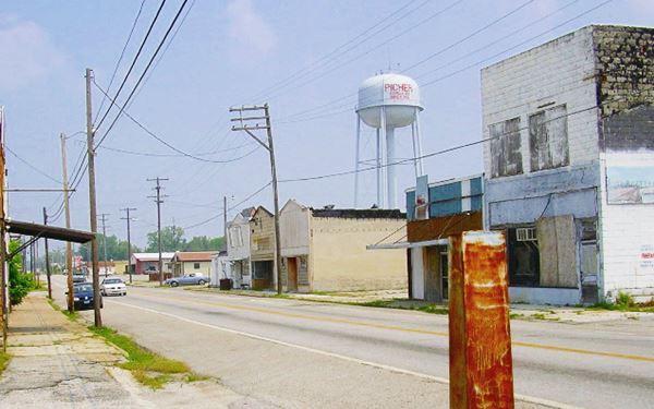
See the Street View of this same place today
Picher is now a ghost town but it used to be a city in Ontario County and was one of the major mining areas in the Tri-State Mining region.
Almost one century of mining had a heavy toll on the community: A local creek turned red in 1967, dyed by the contaminated water from the mines and the gigantic piles of mine tailings or "chat" that towered over the town were laced with large amounts of toxic heavy metals which leeched into the groundwater.
The area was declared the "Tar Creek Superfund" site in 1981, but the residents stayed put even though 34% of their children had lead poisoning.
However, when the Army Engineers found in 2006 that the town was at risk of collapsing because 86% of the buildings were undermined by subsurface mine shafts was action taken.
Authorities decided to evacuate it and declare it uninhabitable: Picher and neighboring Treece and Cardin were found too toxic to clean up so a federal buyout paid residents to leave. An F4 tornado hit the town in 2008 and destroyed 150 homes. The town was doomed: it was dis-incorporated on September 1, 2009.
The town (excluding historic buildings) was demolished and the municipality of Picher was officially dissolved on November 26, 2013.
Picher was named after O.S. Picher, owner of the Picher Lead Co. Mining began there in 1913 and the town was incorporated in 1918. It reached a maximum population of 14,252 residents in 1926.
Mining declined and ceased by 1967 but over 100 million tons of rock, sand and sludge taken from the 14,000 mine shafts remained behind.
Spook Lights
The Tri-state corner area, where Missouri, Kansas and Oklahoma meet is the site of a mysterious phenomenon known under various names: "spook lights", "ghost lights", "Indian lights" and "Hornet lights" (after the town of Hornet, Mo.)
> > Click to read about the Spook Lights on Route 66
Is Route 66 haunted? Learn about its ghosts, phantoms, and spooky places.
Sponsored Content

>> Book your Hotel in Vinita

Credits
Banner image: Hackberry General Store, Hackberry, Arizona by Perla Eichenblat
Jack DeVere Rittenhouse, (1946). A Guide Book to Highway 66
Michael Cassity, 2002 Final Survey of Oklahoma Route 66
Route 66 in Oklahoma, Cassity. 2002
1959 Map Ottawa County
EPA's Cleanup of the Eagle-Picher Henryetta, Oklahoma, Site, 2003 U.S. Government Accountability Office (GAO).


