Where East Meets West
Index to this page
About Quapaw, Oklahoma
Facts, Trivia and useful information
Elevation: 846 ft. (258 m). Population: 834 (2025).
Time zone: Central (CST): UTC minus 6 hours. Summer (DST) CDT (UTC-5).
Quapaw is a small town located just north of Commerce and Miami in the northeastern corner Oklahoma, in the Kansas - Oklahoma - Missouri "Tri-state" region.
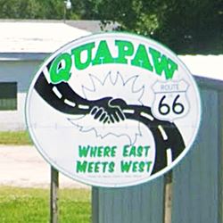
Its nickname are "Hay Capital" and "Where East Meets West".
The Historic Route 66 is the town's Main Street, and crosses Quapaw from North to South.
The History of Quapaw
Visit our Miami, History webpage for full information on the region's history.
The name: Quapaw
The town's name comes from the Native American people who were made to settle here after being displaced from their lands in Arkansas.
In their language, their self-given name Quapaw (O' gah pa) means "Downstream people" and "Those broken off the main stem" (Lost tribe).
The Quapaw Indian Agency
The Quapaw Indian Agency was responsible for the territory that spanned 220,000 acres of what today are Ottawa and Delaware Counties in Oklahoma.
It was created in the late 1830s to be given to the Quapaw Tribe. It was disbanded in 1890, but established again in 1920.
The area was settled by 24 Indian groups that mingled and intermarried, among them were the Miami, Eastern Shawnee, Modoc, Ottawa, Peoria, Seneca, Cayuga, and of course, the Quapaw.
The Quapaw Nation
The Spanish explorer DeSoto encountered them during his expedition in 1541. The French encountered them again in 1673, along the Arkansas River and its confluence with the Mississippi River. Contact with Europeans brought disease that decimated the tribes.
Migration to Oklahoma
After 1824 their migrations began, they ceded their lands and moved to the Red River, returned to Arkansas and then moved to what is now Oklahoma (1834), to the Indian Territory, where Quapaw is now located. Some groups returned to Arkansas (1837) while others moved to Holdenville in OK, in 1840. Those in Ottawa County moved closer to Baxter Springs (1854). Some groups moved with the Osages to Osage Nation Indian Territory (1861).
By 1868, those living in the Reservation were starving, but they remained on their land because the original 1833 Treaty stated that their title to the reservation was only valid as long as the Natives existed as a Nation or continued to reside on their land. As almost 80% of the tribe lived in the Osage land, they decide to expand and adopt individuals to come and live on the reservation. By 1889, they left the Osage land and came back to their territory.
Between 1893 and 1896 each tribesman was given between 200 and 240 acres of farmland.
Isaac Bingham settled in the area in 1891, he ran a farm and some businesses there. And a small community soon sprung up (future Quapaw). The school St. Mary's of the Quapaws was established in 1894 on land donated by Chief John Quapaw (it lasted until 1927).
The natives (as well as the settlers) were farmers and produced hay (that is the origin of the town's nickname) and other farm products for the surrounding towns.
The Kansas City, Fort Scott & Memphis Railroad built a station there and a post office opened in 1897. That same year lead was discovered
A town was platted and land was purchased for that purpose from Harry Whitebird. Quapaw was incorporated in 1917. The demand for workers at the zinc and lead mines led to a boom in the population. By 1920 almost 1,400 people lived in the town.
Imperial mine operated to the west of the town, and Ontario smelter which refined zinc ore was located between Hockerville and Quapaw.
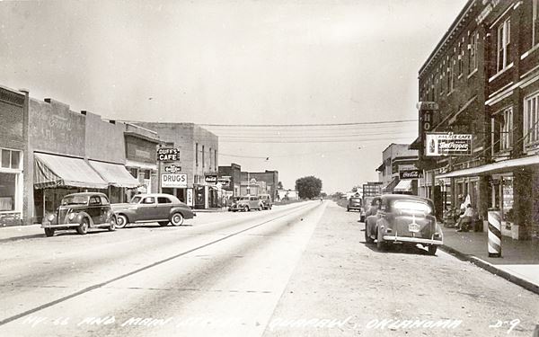
Route 66 was created in 1926 and it passed through Quapaw, the road was later paved and brought travelers and more prosperity.
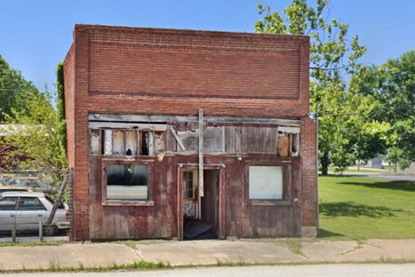
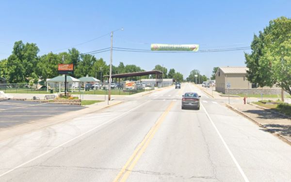
The sequence of images below shows the same spot on Main street (Route 66) over the course of decades (and a tornado in 2014):
Decline in population, buildings razed.
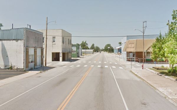
After the 2014 tornado, more buildings were torn down.
The mines gradually became exhausted and by the late 1950s began closing. At that time Route 66 was ageing, it was not very safe and had a lot of traffic. The Interstate highways were replacing it: in 1957 I-44 (the Turner and the Will Rogers Turnpikes) had linked Oklahoma City and Joplin, MO. They bypassed this section of Route 66 in Oklahoma.
Business decreased and the locals went back to farming and ranching. Population dropped.

Hotels in Quapaw
There is no accommodation in Quapaw. However, you will find hotels and motels in neighboring Miami. Alternatively you can also find accommodation nearby, on Route 66 in Kansas and Missouri.
> > Book your hotel in Miami
Lodging Along Route 66
There are several hotels in the area close to this town. Alternatively you can also find your accommodation along Route 66 in the neighboring towns and cities. We list them below (listed from east to west):
On Route 66's Main alignment
Eastwards
Westwards
>> There are two RV campgrounds close to Quapaw.
Quapaw’s Weather

Location of Quapaw on Route 66
Check the Weather in Miami region for historical weather information.
Tornados
Tornado Risk: The deadly April 27 - 30, 2014 tornado outbreak struck Quapaw, killing one resident. It lies within the Oklahoma "Tornado Alley and experiences on average nine tornado watches every year.
Read more about: Tornados on Route-66.
Map of Route 66 in Quapaw
See the description of this segment in our KS-OK state line to Vinita webpage.
The interactive map below shows the alignment:
map of this segment in Quapaw.
Maps showing the alignment of US Highway 66 through Quapaw
The following map was published in 1924 (two years before Route 66 was created). It shows the "Auto Trails" or roads that could be used by cars. Quapaw is on the central-left side. The trail marked "50" was the Ozark Trail and went from Baxter Springs to Commerce.
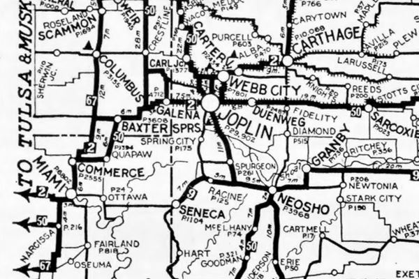

1927 Map Federal Aid Highways, Source
The next map was published in 1927. It shows the highways built under the 1921 Federal Aid Highway System. There is no highway between Miami, Commerce and Quapaw. The Federal funded highway runs through Cardin and Picher.
Route 66 alignment in Quapaw
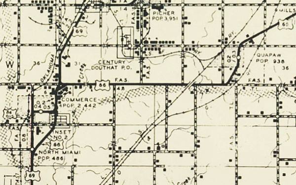
The original 1926-32 alignment according to the Oklahoma DOT maps followed the course shown in this Map. South of Quapaw it had an "L-shaped" course (See map) until 1932, when a soft curve made it safer and shorter. The railroad underpass west of Quapaw (Street view) was built in 1939.
The highway was paved in 1933 with Portland cement, the first one (1926-32) was a dirt road.
Check out Quapaw on our Map of Route 66 in Oklahoma, which has the complete alignment of the Mother Road across the state and all the towns along it.
Route 66 Alignment near Quapaw
Visit our pages with old maps and plenty of information of the old US 66 roadway.
- Vinita to Tulsa (next)
- KS-OK state line to Vinita (Quapaw's)
- Ribbon Road or Sidewalk Road. (original road)
- Route 66 in Kansas (previous)
Route 66 landmarks & attractions
Sights in Quapaw
- In Quapaw, read on below
- Tours & Itineraries
Jack DeVere Rittenhouse wrote "A Guide Book to Highway 66" after driving the from Chicago to Los Angeles along US66 in 1946, he described Quapaw.
Quapaw. (Pop. 1,054; alt 840'; Gateway Hotel; Lucy garage; gas; few stores.) Rittenhouse (1946)
He also mentioned that it was located on the Quapaw Indian Reservation and included a remark about the Quapaw Pow-Wow, held every Fourth of July at the "Devil's Promenad" bluff the the east of town. Which is no other than the "Lover's Leap" site on Spring River.
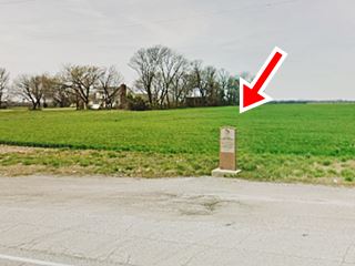
We will begin our City Tour on the Kansas state line and drive west. Just 700 feet south of the state line is the historic marker.
Entering Indian Territory Marker
The pink granite is on the right, on the western side of Route 66. The text on it says: "Entering Indian Territory - In 1833, this area ceded Quapaw Tribe by U.S. Lands near granted Indians of 20 tribes including Seneca, Shawnee, Peoria, Miami, Ottawa, Wyandot. Wealth came to the Quapaw and to other Indians here, from discovery of rich lead and zinc mines beginning 1905.".
One quarter of a mile ahead, to your right, S 630 Rd. forks from the main highway: it was the original unpaved alignment of US66 into Quapaw. Continue west on US66-69 through the fields and farms for another 2.5 miles, at the SW corner of S 614 Rd. was the site of a Route 66 Trading post.
Indian Village Trading Post
An eye catcher during the 1950s, it had teepees and local residents dressed up as indians with headdress. It sold souvenirs to the tourists. The postcard pictured below said "...is Oklahoma's largest and most complete Indian Trading Post. Features authentic Indian dancers, Buffalo herd, Texas Longhorns, Rodeo Arena". Now it has vanished, some trees mark the outline of the old trading post.
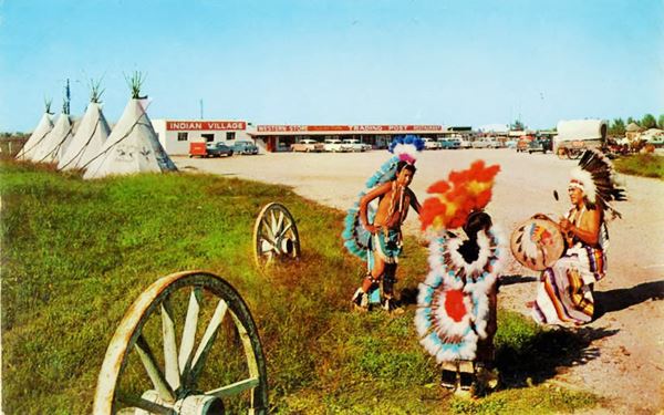
See it in this 1958 aerial photo that even shows the teepees to the left of the parking lot, and this current satellite view, where all that remains are the concrete foundations of the building.
Head straight into Quapaw (1.3 miles). To your left is E 1st St., which was the 1926 alignment of Route 66 coming from Baxter Springs.
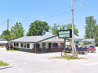
Dallas' Dairyette
To your right, at 103 E Main St, is has been run for over 50 years as a family operated restaurant. Dallas Wall opened it back in 1969. Stamp your Route 66 passport here and taste their burgers and cowboy steak sandwiches.
Facing it, across Route 66, is the defunct Hemi's Cafe, established in 1997 as "69A Cafe" by Vivian and Henry Foster, Sr. It closed for good in 2018.
Drive along Main Street. The area has lost many buildings, and was hit by the 2014 tornado. There has been some urban development with a park on W 4th and Main.
Site of Casa Loma Motel
Just ahead passing 5th St. to your right, at 513 Main, was the site of the "Casa Loma Court", a motel. It had a U-shaped layout with an office in the middle. Now it is an apartment complex with separate one-story units. The original buildings were torn down. Street view.
Ahead, just before the fork where the 1926 US 66 keeps straight south, and the later 1930s alignment curves to the west, is the "Where East meets West" road sign (to your left).
Take the 1926 alignment to visit the local museum (Map with directions 0.8 mile drive).
Quapaw Tribal Museum
905 Whitebird St., Quapaw. A place to learn more about the tribal history, traditions and artifacts of the Quapaw people. (website
Annual Quapaw Pow Wow
This is the event mentioned by Rittenhouse. The Quapaw people have been holding their gathering for over one hundred and forty years; they began in the period of the America Civil War.
Learn more at the official Quapaw Tribe Website
Pow Wow
The word can be written powwow, pow-wow, pow wow or pau wau. It is a gathering of Native Americans, and the word originates from the Narragansett language.
This ends your city tour of Quapaw. You can head west along Route 66 into Commerce, or take some side trips in Quapaw.
Tours & Itineraries near Quapaw
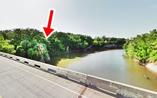
Lovers' Leap
On the bridge of E 57 Rd. over Spring River, very close to Quapaw. (Map).
Leave Quapaw (mile zero) and head south along Route 66, at the end of town the road curves towards the right as S. Main St. Keep straight own along Main St. and turn right after 0.4 mile. Head eastwards along E 50 Rd., drive through Lincolnville and turn right on S630 Rd. The road will become E 57 Rd, and cross Spring River (3.6 miles).
You will see, on the west bank of the River, right to the north of the bridge two rock buffs, known as "Lovers' Leap".
The local legend tells about young Indian warrior who fell in love with a girl of the Quapaw tribe, but the maiden's father asked for a large payment for his daughter's hand. The lovers eloped but their escape was discovered and the angry Chief sent a party to capture them. The couple knew their fate: death, so they chose to die together by jumping off the rocky cliff which is now known as "Lovers' Leap" or "Devil's Promenade"
Spook Lights
The Indian lover's myth blends with another local myth, the "Spook Lights" legend.
A local phenomenon called Spook Lights is said to be caused by the nightly return of the young couple's ghosts to the spot where they died.
Spook Lights, the legend
The Tri-state corner area, where Missouri, Kansas and Oklahoma meet is the site of a mysterious phenomenon known under various names: "spook lights", "ghost lights", "Indian lights" and "Hornet lights" (after the town of Hornet, Mo.).
> > Click to read about the Spook Lights on Route 66
Sponsored Content

>> Book your Hotel in Vinita

Credits
Banner image: Hackberry General Store, Hackberry, Arizona by Perla Eichenblat
Jack DeVere Rittenhouse, (1946). A Guide Book to Highway 66


