
Route 66 in Gallup NM
Index to this page
About Gallup, New Mexico
Facts, Trivia and useful information
Elevation 6,468 ft (1.971 m), population 19,548 (2025).
Time zone: Mountain (MST): UTC minus 7 hours. Summer (DST) MDT (UTC-6).
Gallup is the county seat of McKinley county, and is the most populous city along Route 66 between Albuquerque NM and Flagstaff AZ. Its native Navajo name is Na'nízhoozhí.
History
New Mexico has been inhabited for more than ten thousand years. In historic times, the Pueblo people lived in the valleys and used the rivers to irrigate their crops of corn and squash. The Zuni Pueblo people were the first to meet the Spanish when Francisco Vásquez de Coronado's expedition reached the area in 1540 searching for the wealthy cities of Cibola.
Gallup's Main Street

Lack of gold dismayed the Spanish who put off conquering the region until 1597, when they incorporated it to their American Empire. The Pueblo Revolt in 1680 expelled the Spaniards until 1692, when they returned and subdued the Natives.
The Navajo people from the north raided these Spanish pueblos and settlers constantly. In 1821 Mexico won its independence from Spain and New Mexico became part of the new country but after its defeat during the 1846-48 war with the U.S., Mexico ceded it to the victors.
The American Army scouted the area and an expedition led by Lt. Edward Fitzgerald "Ned" Beale passed through Gallup en route to the Colorado River in 1857 (it used camels as pack animals). The constant warfare with the Navajo led to the establishment of The "Old" Fort Wingate near Grants in 1862, which in 1864 moved to Wingate, just east of Gallup.
The name: Gallup
David L. Gallup was an auditor and paymaster for the A&P Railway, he was based at this station, and the railway workers used to go to "Gallup's" to collect their paychecks.
By the way, Gallup is an ancient name dating back to Anglo-Saxon Britain and meant a fast runner (old Norse "walup"), it evolved into "wallop" and "gallop".
The Atlantic and Pacific Railroad (later the Atchison Topeka and Santa Fe RR) laid its tracks west, across the continental divide and built a stop at its railhead in 1881 which it named Gallup.
The spot had been chosen because it was a stage coach stop and because there was a small village including a saloon, general store (the Blue Goose). The local Navajo Indians traded there and knew the town as "spanned across" in refrence to a footbridge across the Western Rio Puerco River next to the station.
Right from the start, the coal mining industry was important as there were mines located very close to the town (see Defiance, just 9 mi. west of Gallup on Route 66). It was shipped out by rail. Water was scarce so wells were drilled. The town incorporated in 1891.
In 1926 Route 66 was aligned through the town following NM state highway 6 and the town began catering to the travellers. It cultivated a mysterious air of Western and Native American charm which attracted tourists. It adopted the name of the ""Heart of Indian Country" as it lies in the middle of the Navajo Reservation and many local residents are of Native American origin.

Where to Stay: Find your Hotel in Gallup
There are plenty of accommodation options on Route 66 in Gallup so you won't have difficulty to book your room in the city:
> > Book your Hotel in Gallup
More Lodging Near Gallup along Route 66
Below you will find a list of some of the towns along Route 66 in New Mexico. Click on any of the links to find your hotel, motel or accommodation in these towns (listed from east to west):
On Route 66's Main alignment
The Santa Fe Route 66 segment
Eastwards
Westwards
>> There are RV campgrounds in Gallup
The weather in Gallup

Location of Gallup on Route 66
Located in the high western part of New Mexico, Gallup has a semi-arid climate with hot summers and cold winters. The altitude and dry air make summer nights cool and winter nights very cold.
The average summer high is 89°F (32°C) and the low is a cool 51°F (11°C). During winter the average high is 45°F (7°C) and the average low is a chilly 11°F (-12°C).
The annual rainfall is relatively scarce: 11.5 in (292 mm), with most rain taking place between July and Nov. (6.81 in, 173 mm). There are 71 days per year with precipitation.
Snow is common during winter, and quite heavy averaging 30.4 inches (77.2 cm) and it falls at any time between Oct. and May, but mostly between Nov and March.
Tornado risk
There is virtually no tornado risk in Gallup: McKinley County has no Tornado watches. The area west of this point has no tornado events at all.
Tornado Risk: read more about Tornado Risk along Route 66.
Map U.S. 66 in Gallup New Mexico
Read the Detailed Description of this segment (Albuquerque to Lupton). Below is the interactive map:
>> Custom map of Route 66 in Gallup
Maps of Route 66

Gallup is the largest city in the western New Mexico alignment of Route 66. The highway crossed the town from east to west as shown in the following map, and runs westwards for 10 mi. without any gaps until it reaches Defiance. US66 map west of Gallup to Defiance.
Defiance
At Defiance, just east of the NM Gallup Port of Entry, U.S. highway 66 is cut by I-40 as marked with a blue line in our custom map. It resurfcaces on the south side of the freeway for only 1.3 miles (map) before being overlaid by the freeway once again all the way to Exit 8, where it crosses to the north side of the Freeway and the railroad to follow NM-118 westwards. This gap is marked with a yellow line.
Route 66 Alignment near Gallup
With maps and full information of the old roadway.
- Lupton to Winslow (next)
- Albuquerque to Lupton (Gallup's)
- Santa Rosa to Albuquerque (previous)
Gallup: its Attractions
Landmarks, Route 66 sights in "The Indian Capital of the World"
Historic Context
In 1946, Jack DeVere Rittenhouse wrote his "Guide Book to Highway 66" in which he mentions Gallup as follows:
hotels: El Rancho, El Navajo, Delmar, Grand, Liberty; courts: Casa Linda, Fonda, Log Cabin, All States... Gallup is a great Indian trading center, to which they come for supplies and from which Navajo and other Indian wares are shipped. It is also famous for its great Inter-Tribal Indian Ceremonial held annually just after the middle of August. Rittenhouse (1946)
Your Route 66 Road Trip across Gallup
We will tour Gallup driving westwards along Old Route 66 from neighboring Rehoboth.
Kachina Doll Sign

Roadside Kachina nowadays, Gallup US66 NM. Click for St. view
For many years, those arriving to Gallup along Route 66 encountered a large roadside Kachina doll sign on the north side of the highway, its base announced "GALLUP N.M. THE INDIAN CAPITAL" and also informed the date of the Indian Ceremonial. This aerial photo from 1952 shows it. This map marks the spot on US66.
It was taken away many years ago, but you can see one -is it the same one? or a copy? in the City Park on the north side of Gallup map marking the spot. Compare it size with the RV in the picture!

Shell
At Exit 26, I-40 crosses Route 66 and the railroad, and bypasses the city along its northern flank. Ahead, to your left at 3400 E US Route 66 is a former Shell Station from the mid 1960s to 1970s, with its typical Ranch style sloping roof, glass transoms over the former service bays and an extension from the roof where the company's logo used to be. It was probably Marshall's Shell Service on "East Hwy 66". The steel signpost to lure freeway driver stands vacant over the building that has been modified and converted into a clinic.

1960s Shell Station, Gallup US66 NM. Click for St. view

1960s Mobil Station, Gallup US66 NM. Click for St. view
Jack's Indian Hills Mobil
Just beyond Gallup's Islamic Center (site of the former Gallup Shamrock station), to your left at 3020 E Hwy 66 is a former Mobil gas station, now Roadrunner Auto Sales. Its office has canted multi-window from the 1950s. It has two service bays, and a long flat canopy over two empty gas pump islands (1).
Road Runner Motel & Restaurant ❌
At 3012 E 66, to your left was the Road Runner Motel with 31 units built in 1962 and torn down in around 2017. See the motel in this 2012 Street view shortly after the cafe burned down -its sign was still standing at that time. The motel to the left had a wonderful 1950s neon sign.

La Hacienda Courts
At 2510 E Hwy 66, to your left is the former Hacienda Hotel. It opened in 1950 and was the place "Where the Summer Nights Are Always Cool". The 32-room motel had a U-shaped layout and was closed by the City of Gallyp due to building code violations and safety concerns.

La Hacienda Court 1950s. Gallup NM Route 66. Source. Click to enlarge

La Hacienda motel nowadays, Gallup US66 NM. Click for St. view
At 2500 E 66 to your left is the Wildcat Service and tires, it used to be Tom's Malco Service (Street view).
Casa Linda ❌
Ahead, to your left at 2300 E Rte 66, where the McDonald's now stands was the classic Casa Linda Motel had a white stucco with vigas Pueblo-style building. Its 38 units included fre ice, baby cribs and alarm clocks. It opened in 1937. Gone by the 1970s.


Earl's 1960s advertisement Gallup NM Route 66
Continue westwards along Higway 66 for 0.7 miles.
Earl's Restaurant
To your left, at 1400 E Hwy 66 is this classic Restaurant, but few know that its original 1947 location was across the street, to your right, at 1321 E Hwy 66 where the furniture shop is now located.
Its advertisement from the 1960s announcing it was open freom 5 AM to Midnight and some of its dishes: "Pancakes, Steaks, Mexican Food, Honey Golden Fried Chicken". Below is a Then and Now view of the site.

Earl's Restaurant in the 1960s, Gallup NM Route 66. Source. Click to enlarge

Earl's original location, Gallup US66 NM. Click for St. view
Denny’s Diner
To your left adjacent to the "new" Earl's, at 1310 E Historic Highway 66. The Avalon Restaurant is housed in a former Denny's Diner with its classic "Boomerang Roof". It was a design from the early 1960s by Armet & Davis. Below is a Then and Now set of pictures.

1960s Denny’s in Gallup by A. Whittall. Click for street view

Denny's 1960s postcard Gallup NM Route 66. Source.
Click to enlarge
Georges 66 Plaza Mobil
At 1305 E 66, opposite the former Denny's is another 1950s gas station, a former Mobil (in 1979). Now a tire shop (St. view).
El Capitan Motel ❌
To your left at 1300 E Hwy 66, with 40 rooms and a heated pool, it offered singles, doubles and family suites. Torn down 2022 after being condemned by the city.


Pete's Conoco
At 1220 E Hwy 66, to your left is the former Pete's Conoco and Radiator Service. Now it is Leyba's Auto Clinic. The building has an angled corner office with two service bays along We St. This is its St. view.
Ray's Phillips 66
Also to your left, at 1206 E Hwy. 66 is what remains of the former Ray's Phillips 66 station, the service bays have gone, the office remained (Street View).
To your right are three classic Route 66 motels: Arrowhead Lodge, Blue Spruce and the Lariat.
Arrowhead Lodge
On the north side of the highway, the 25-unit Arrowhead at 1115 E Hwy 66 has a U-shaped layout around a central courtyard. Currently closed. The classic neon sign is still there. Notice that in the 1950s it had a sign shaped like a stone arrowhead that in the late 1950s was replaced by the current one with a Space-Age look to it.
The 1966 phone book advertisement pictured below shows that the Arrowhead, Zia and Lariat motels were part of the same group: "Your host: Rios - 3 Locations."

1960s motels advertisement. Click to enlarge

Arrowhead Motel nowadays, Gallup US66 NM. Click for St. view

Blue Spruce Motel
Next comes the Blue Spruce Lodge, with 19 units and owned and managed by Mr. and Mrs. John Milosevich. The motel is still operating and its spruce-shaped neon sign is there too!


Blue Spruce Neon Sign, Gallup US66 NM. Click for St. view

Lariat Lodge Neon Sign, Gallup US66 NM. Click for St. view
Lariat lodge
Adjacent to the Blue Spruce, to your right, at 1029 E Route 66. This motel opened on July 4, 1952 with 35 rooms and a sign that displayed a cowboy with a lariat (a lasso) pictured further down, later replaced by the current sign pictured above.
Lariat Lodge


1950s Lariat Lodge, Gallup NM Route 66. Source. Click to enlarge
Ahead after the Hershey Miyamura overpass, to your left is a historic site.
H. Miyamura Korean War Hero
Hiroshi "Hershey" H. Miyamura (1925-2022) was a United States Army soldier who received the U.S' highest military award for bravery, the Medal of Honor, for his actions during the Korean War.
El Rancho Hotel
1000 East 66 and Ford Dr. , Gallup, NM.
Listed in the National Register of Historic Places
El Rancho Hotel is an iconic Route 66 motel linked to the movie business, built on a grand scale after R.E. "Griff" Griffith, the brother of the famous movie director D. W. Griffith visited Gallup in the 1930s. Griff fell in love with the city and in 1936 commissioned Joe Massaglia to build a magnificent hotel.

The three-story building has an air of a Southern mansion and was built of brick, stone and wood. The fireplace, hunting trophies and Navajo rugs create a hunting lodge ambiance. It could accomodate 420 guests.

Below is a photograph I took fo El Rancho Hotel in 2016:

From the start the hotel was linked to Hollywood crews and stars filming on location and remained so until the western movies' popularity waned in the late 1960s.
John Wayne, Ronald Reagan, Errol Flynn, Kirk Douglas, Humphrey Bogart, Katherine Hepburn, and Spencer Tracy are some of the stars who stayed at El Rancho Hotel.
Among the films shot in Gallup we can mention: Billy the Kid (1930), The Sea of Grass (1947), Four Faces West (1948), Only the Valiant and Ace in the Hole (1951), Escape from Fort Bravo (1953) and The Hallelujah Trail (1965).
There were two gas stations here, both gone gone ❌ opposite the hotel, to your right, Doc's Humble Products Service (1001 E Hwy 66) and Biggs Standard Station (1015 E Hwy 66).
Former El Rancho Shell Gas Station
The El Rancho Shell Station (1000 E Hwy 66), later it became an Armco Service Station when I photographed it in 2016 (see below). At that time it had a long canopy and a tall steel tower to make it visible from the freeway. In 2022 the canopy and singpost have been removed leaving the rock faced building and two service bays.:
Former El Rancho Shell, later Armco Gas Station

Across the highway to your right you will see the Zia Motel followed by the Redwood Lodge and the El Coronado Motel, three classics as you approach the East Y, the fork or junction where Coal St. and Route 66 meet on the eastern side of Gallup.

US 66 Neon Signs in Gallup. A. Whittall

Historic US 66 road sign in Gallup. A. Whittall
Zia Motel
To your right at 915 E Hwy 66 the motel is still there. Its postcard says it was located "On Highway 66 -East Y ... A Modern Motel 26 units... large airy rooms of all sizes for family accommodations. Homelike. Comfortable and Quiet." Closed and condemned by the City.

1950s Zia Motel, Gallup NM Route 66. Source. Click to enlarge

Zia Motel (2022), Gallup US66 NM. Click for St. view
Redwood Court - Jim's Modern Court
Listed in the National Register of Historic Places
Jim Dougherty built it in 1931, he was a mechanic and had his garage in the building that is now the management's office (notice the service bay in the vintage postcard below). The motel was known as Jim Dougherty's Court and also as Jim's Modern Court. He ran it until he retired in 1952 and sold it to Steve and Mary Rudick. They renamed it "Redwood Lodge" and adapted the garage to serve as their home on the property. The Rudick's sold it in 1983 to the Historic and Architectural Resources of Rt. 66 (2). Below is a postcard and further down its current appearance.


Redwood Lodge nowadays, Gallup US66 NM. Click for St. view

El Coronado nowadays Gallup US66 NM. Click for St. view

1958 advertisement Coronado, Gallup NM Route 66. Source
El Coronado Motel
The El Coronado motel advertisment in the 1958 Gallup telephone directory (see image) tells us it had a "Service Garage & Court... Firestone Tires Texaco Products... Modern Motel 823 E 66 Av. at East Y - Walter Milosevich."
Its neon sign dates back to 1959 and is the work of Albuquerque Zeon Sign Co.
Now it is closed. See picture further up. This aerial photo from 1952 shows the garage in the front-central part of the courtyard, the gable roof building in the back of the property that now serves as the office was added at a later date.
To your left was Pete's Cafe ❌ at 823 E 66 and next, on the Y itself, SE Corner with S. McKinley Dr. was Allen's Conoco ❌ now a modern but vacant gas station stands on the property. Below is a 1950s view looking east from thge Y. You can see Pete's Cafe (right), the Coronado Texaco, and Redwood Court's neon sign (left). This is the same view nowadays.

Motel at the Y?
In the 1950s and probably earlier, and into the 1960s, the apex of the eastern Y between Coal St. and E Route 66 was occupied by a Z-shaped building, with a central office (?) on the north side facing Route 66. If it was a motel we have not found any records of it. The eastern leg of the "Z" survived as Pete Leyba's All Indian Jewelry store. You can see the image, an aerial photo from 1952 with this building highlighted in the red box. To the west you can see All States Court marked (1) and the American Court marked (2). A mystery!

Old motel? Gallup 1950s. Aerial photo

Looking west at the East Y c.1940s. Click image to enlarge
The image above looks westwards towards the East Y (click on it to enlarge it). The numbers show from left to right Pete's Cafe (1), Pete Leyba's Store (2) with a gas station (?) in front of it, the "mystery" Auto Court Sign (3), Coronado Texaco (4) and Redwood Court (5). Perhaps the property was part of All State Auto Court?
At the Y, Route 66 opens slightly at the "Y" and becomes a wide two-way avenue that was built in 1956, widening the original narrow street (it had been Railroad Ave. until Highway 66 was aligned along it in 1926).

The former Whiting station in Gallup. Click image for St. View
Whiting Bros Station #12
Continue west. To your left, at 700 E Route 66 on the south side of the road where the mystery motel was located is a used car dealership.
A Whiting Bros. station was built on the property after the motel was torn down, and remained open until the early 1980s then it became Danny's Auto Sales. The original service station building was razed around 2004 and was replaced by a new one. However, the original canopy is stil there.
Below is a vintage photo ca. 1980s of this station with the full Whiting Bros. regalia. As you can see, the canopy is the same. In the distance you can see the El Rancho Shell sign (right) and the El Coronado motel neon sign (left) at that time painted blue and white.
Whiting Bros. Station #12 in 1980

All States Court

All States Court c.1950s. Gallup NM Route 66. Source. Click to enlarge
Just beyond the eastern Y and its unnamed motel, at 608 E 66 to your left was a classic motel: The All States Court. It opened in 1938 and Dino Ganzerla owned it. It had 19 units aligned parallel to the highway. This was the stop of the old Overland Stagecoach. The place was razed in the 1970s. You can see it in this 1952 aerial photo back to back with the American Court ❌ on Coal St.
Gallup Commercial Historic District
Listed on the National Register of Historic Places
You now enter the historic district of downtown Gallup, covering several blocks along Route 66 and Coal Avenue. Here are many buildings form the days of the coal boom, trading with the Navajo, and catering to those traveling along Route 66 or the A.T. & S.F. railroad (3).
To your left at 300 E 66 is a block-shaped building selling native crafts: Zuni Fetishes, that used to be Stock's Philliups 66 Service Station. Long before, the Sanborn Insurance map of 1922 shows a garage on that property.
Liberty Hotel ❌

Liberty Hotel in 2012 (now gone) Gallup US66 NM. Click for St. view
At the corner, to your left, half a block along South Strong St., on the western side of the street at 108 S. Strong, was the Liberty Hotel mentioned by Rittenhouse in 1946. It was torn down during a redevelopment project (Hoogahn Hozho Apartments). You can see it in the image while it was still standing back in 2012.
Drake Hotel
Listed on the National Register of Historic Places
On the next block along Route 66, at the corner (216 E 66) is Drake Hotel, also known as Henry Hotel; it is a two story brick building dating back to 1919 during Gallup's Second Coal boom. The Sanborn map from 1922 states that Beddow Buick Co. had ist sales room and 30 car-capacity garage on the first floor and that the Roma Hotel was on the second floor with 16 apartments. Later it became the Drake Hotel. It had steam heat, showers and a garage.

Drake Hotel c.1930s, Gallup NM Route 66. Source. Click to enlarge

Drake Hotel nowadays, Gallup US66 NM. Click for St. view
Navajo Hotel Site - Gallup Cultural Center
At 201 E 66, across from the hotel, to your right is Cultural Center built on the site of the now gone El Navajo Hotel mentioned by Rittenhouse in 1946. The hotel was one of the "Harvey Hotels" built on the Atchison, Topeka and Santa Fe Railway and it included as its eastern wing, the Gallup railway depot built in 1917. It was built in 1923 and torn down to make space for a wider Route 66, a great historic loss. This is the 1922 Sanborn map showing it, opposite S. Puerco St.

A new building was built on the property with a style similar to the one of the old hotel, and it is also the Amtrack station for boarding and traveling on the Southwest Chief, that stops here with daily services. Don't miss the Code Talker Statue facing Route 66.
Code Talkers
The U.S. Army employed Navajos to transmit coded messages in their obscure language, Diné during World War II and the Korean War. The Navajo language was complex, unwritten. and known only to the native speakers who were all American, making it ideal for the purpose. It was used by the U.S. Marines in the Pacific War Theater against the Japanese and played a major role with their uncrackable code.
Delmar Hotel
On the next corner (100 E 66) SE corner with S. 1st St. was the Delmar Hotel mentioned by Rittenhouse in 1946. There is a building on the corner, but we don't know if it is the original one.
White Cafe
Listed on the National Register of Historic Places
On the next corner, also to your left, at 100 W 66 was White Café it opened in 1928 and catered to Route 66 travelers and railroad passengers

White Cafe 1930s Gallup NM Route 66. Source. Click to enlarge

White Cafe nowadays, Gallup US66 NM. Click for St. view
Southern Hotel
Listed on the National Register of Historic Places
Adjacent to the cafe at 103 W 66. The two-story blond-brick building dates back to the early 1900s (3).
Head west and on the corner with S 2nd St. there were two hotels in the 1922 Sanborn map, the Page Hotel at 124 W (SE corner) and, next to the Bank at 206 W was the Commercial Hotel.
Kitchen's Opera House
To your left, at 221 West Route 66. This is one of the oldest buildings in Gallup, it was built in 1895 by Pat Kennedy and Pete Kitchen. A two-story brick building that has hosted movies, boxing matches, sports, political and social events for nearly 130 years. "Opera House" was a name adopted in the West for theaters where the local mining communities could get together and feel sophisticated and successful.

Kitchens Opera House. Click for St. view

Richardson's Trading Post neon sign. Click for St. view
Next door to Kitchens, at 223 W Hwy 66 is a classic trading post active since 1913, Richardson Trading Post with a great neon sign, pictured.
Adjacent to Richardson's on the SE corner with S 3rd St. is the Palace Hotel Building Listed on the National Register of Historic Places at 235 W 66 it opened in 1912 and was built in a Richardsonian Romanesque style. Across the street is another historic hotel:
Rex Hotel (Museum)
Listed on the National Register of Historic Places
On the SW corner with 3rd St., at 301 West Historic U.S. Highway 66, Gallup NM.
The Sanborn map marks this spotas the Angeles Hotel (1922), later the Rex Hotel, said to be a brothel. Now it houses a museum with collections and artifacts from Gallup's past. It has a great "retro-vintage" neon sign as does the adjacent parking area. Both signs are pictured below.

Rex Museum retro-vintage neon sign, Gallup US66 NM. Click for St. view

Downtown Parking retro-vintage neon sign, Gallup US66 NM. Click for St. view
The image below taken in the mid 1950s before Route 66 was widened, shows the traffic along the narrow W 66 in those days. The picture was taken from the Rex Hotel looking east. Notice the tracks to the left, the Palace Hotel on the corner with the "Hotel" sign, and the curio sign (Richardson Trading Post) and beyond it the facade of Kitchen's Opera. The old Navajo Hotel can be seen in the distance, to the left, beyond a truck. This is the current street view from that same spot.

Lexington Hotel
At 407 W 66, to your left, the Lexington was built in 1931 in local stone. It has two neon signs, the original sign is the top portion, the smaller green rectangular sign was added around 1970. They were both restored by Hinkley Signs of Gallup as part of a Route 66 neon sign restoration project in 2003.

Lexington Hotel, Gallup US66 NM. Click for St. view

Old Gas station, Gallup US66 NM. Click for St. view
Old Gas Stations

Glenn's Bakery retro-vintage neon, Gallup US66 NM. Click for St. view
Just west, on the corner at 431 W 66 is a gas station that appears in a 1952 aerial photograph but has been greatly altered from its original design.
There is another gas station built in 1948 at 511 W 66, with a flat canopy over the vacant pumps island and corner office on S 6th and Route 66. It has two service bays to the left and the steel signpost on the eastern tip of the property. Pictured above.
Across the Street, at 601 W 66 now a tire shop, was the Speedway Mobil Service with three service bays, canted glass-multipane office to the right and a flat canopy (St. view) on the other corner of the same block at 615 W 66 was Del's Phillips 66 Service Station (St. view).
Retro Vintage neon sign at Glenn's Bakery
There are no more classic buildings along this section of W Hwy. 66. At 9th St there is a great retro-vintage neon sign at Glenn's Bakery at one time Red's West Shell and Radiator Service stood opposite, at 900 W 66. Pictured.
West Y
Court Fonda
At the West "Y" was the Court Fonda mentioned by Rittenhouse in 1946, long gone. In 1940 Duncan Hines recommended it and wrote: "Motor Court: Court Fonda. West Triangle. New and good. Hot-water. Heat. 21 rms...FGar. No pets" (4).
Paramount Cafe
At the West Y there is only one surviving classic structure, the former signpost of Paramount Cafe. The Paramount's advertisement from the 1966 phone directory reads: "In Gallup Open 24 hours - Milton & Maize Mueller welcome you to the famous Paramount Cafe - Home of Famous food -Choice Steaks -Chickent -Sea Foods -Mexican Food -Italian Food -Pizza. Private Dining Room for Parties. Take out Orders..." Its signpost was repurposed by the Colonial motel as you can see in the image below:

At West Y you can turn around and drive back into Gallup along W Coal Ave. which formed part of the Route 66 alignment since 1926. We will later detail the attractions Westwards from West Y.
Along Coal St. in Gallup
According to Joe Sonderman Route 66 followed Railroad Ave, to First St. there it turned south to Coal Ave and ran along it to the West Y, continuing west along Railroad Ave.
Pictures from the 1930s show both Railroad and Coal as two-way avenues and signage marking US 66 along Railroad. The 1950s picture below shows eastbound signage (red arrow) and a one-way flow of traffic along Coal Ave. So we can suppose that after WWII and until the four-lane Railroad Ave. was completed in the late 1950s, westbound traffic flowed along Railroad and eastbound traffic along Coal, as shown in the postcard below.
Interestingly, a late 1960s postcard calls Coal Ave "Alternate Highway 66."

1950s Route 66 along Coal Ave. Gallup NM Route 66. Source. Click to enlarge

Route 66 in Gallup NM, 1953 postcard. Source. Click to enlarge
There were several cafes, gas stations and motels catering to eastbound travelers along Coal Ave. We mention these Route 66 landmarks below.
El Ranchito Motel
To your right, at 1009 W Coal, it dates back to the early 1960s. This U-shaped motel's postcard reads "25 spacious, comfortable units...to accommodate from one to eight guests. Every room with tiled tub and shower bath. Air conditioned and hot water heat for winter. Beautifully furnished..." The classic neon sign is gone, but the place is still operating as a motel.

El Ranchito Motel c.1950s Gallup NM Route 66. Source. Click to enlarge

El Ranchito Motel nowadays, Gallup US66 NM. Click for St. view
Colonial Motel
Adjacent to El Ranchito, at 1007 W Coal. This motel already appeared in the 1952 aerial photographs. It had 26 rooms and a U-shaped layout.

Colonial Motel mid 1960s, Gallup NM Route 66. Source. Click to enlarge

Colonial Motel nowadays, Gallup US66 NM. Click for St. view
Cactus Motel ❌

Cactus Motel 1950s, Gallup NM Route 66. Source. Click to enlarge
To your right at 809 was the Cactus Motel (pictured) it had 20 units that later increased to 32, with closed-heated garages around a central courtyard with a two-story office and an amazing neon sign depicting a cactus. One of its 1940s postcards places it on "U.S. Highway 66 (alt)" but another from 1959 depicted below says it is "one block south of Highway 66", showing the changing names and alignments of the Mother Road in Gallup.
Ahead, to your right, on the SE corner with S 8th St. at 711 W Coal was the Twilite Motel ❌ and next to it the Navajo Motel ❌ at 709 W Coal. Now a large Ford dealership occupies the whole block.

1930s Ideal Court. Gallup NM Route 66. Source. Click to enlarge
Ideal Auto Camp ❌
Its postcard stated "West 66" but it was located on W Coal, on the 700s block, opposite the Twilite and the Ford building to your left on the north side of the street. It opened in 1927 and had a U-shaped layout. Its owner was Bert Eddies. There was a Texaco station in the central office and later it sold Sinclair gas. Torn down in the 1990s, now it is a parking space for Gurley Motors Ford customers.
Muffler Man

"Dude Man" muffler man in Gallup US66 NM. Click for St. view
On the NE corner of S 5th St. and W Coal Ave. is Gallup's Muffler Man, on the roof of John's Used Cars (416 W Coal). He sports a cowboy hat and a revolver in a holster he is known as "Dude Man".
At 408 W Coal was the Harvey Hotel ❌, previously known as the West Hotel. And on the next block its competitor:
Grand Hotel
Listed on the National Register of Historic Places
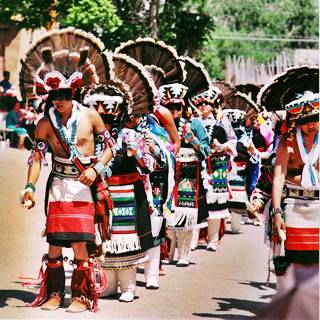
To your left at 306 W. Coal Avenue is the Grand Hotel mentioned by Rittenhouse in 1946. Previously its name had been the Ricca Hotel. It is a two-story brick commercial-style building dating back to the early 1920s. The hotel occupied the upper floor and the first one served as a store and a bus depot. The black and white image below is a detail of a larger one (click on it for a full size view along W. Coal in 1955 during the Inter-Tribal Indian Ceremonial parade) and shows the hotel and what Downtown Gallup looked like at that time. Notice the US 66 shield on the first lightpost (right-center).

Grand Hotel, Gallup NM Route 66. Source. Click to enlarge

Grand Hotel nowadays, Gallup US66 NM. Click for St. view
Historic Chief Theater
Listed on the National Register of Historic Places
At 228 W Coal Ave., it is an Art Deco style building built in 1920 that could seat 670 viewers. The building is still standing and now is a store. Below are a "Then and Now" set of pictures.

Chief Theater 1950s, Gallup NM Route 66. Source. Click to enlarge

Chief Theater nowadays, Gallup US66 NM. Click for St. view
Morro Theatre
Listed on the National Register of Historic Places

El Morro Theater in Gallup. Click for street view
Ahead, to your right, at 207 W Coal Ave. Gallup. The historic theater dates back to 1928. Built in a Spanish Colonial style with Pueblo-Deco touches. It seats 460 vieweres and was restored in 1991.
Ran by the City of Gallup, it is the venue for movies and live performances.
Code Talker Mural

Code Talker Mural, Gallup NM. Click for street view
Visit the Chamber of Commerce (thegallupchamber.com) to learn about the first 29 original Navajo Code Talkers or see the colorful mural at on S. Second St. between Coal Ave. and Route 66.
There are many murals in the downtown district, learn more about them: Murals (external website)
Fred's Conoco Station
On the corner with First St. to your right at 101 W Coal Ave. is the former Fred's Conoco Service Station with an angled office facing the corner. It was on 1st St. that the original Route 66 turned south on Railroad Ave., headed south along 1st and again turned west along Coal Ave. until it became a one way street to carry eastbound traffic in the 1940s.

Fred's Conoco Station. Gallup US 66 NM. Click for St. view

American Court postcard, Gallup NM Route 66. Source. Click to enlarge
American Court ❌
Continue west, and just as you reach the East Y, to your right at 701 E Coal is an empty lot, where the now gone American Court used to stand. It dated back to the 1940s and had a U-shaped layout. Pictured above.
The itinearary across downtown Gallup ends here. Return to the West Y to continue along Route 66 driving through its western outskirts.
Westwards from West Y
More landmarks along West 66
Log Cabin Lodge ❌
At the West Y, as Husband's West Y Chevron station. Long gone. Continue west, just before you reach the overpass of Hwy. 602, to your left, at 1111 W 66 was the Log Cabin Lodge. This motel had log cabin styled units as individual cottages or, as its postcard stated "unique rustic cabins... All with steam heat and refrigerated airconditioning." It opened in 1938 and shut down in the late 1990s. A fire hit it in 2004 and after that it was torn down. Nothing remains of it.

Log Cabin Lodge, Gallup NM Route 66. Source. Click to enlarge

Pine Tree Lodge, Gallup NM Route 66. Source. Click to enlarge
Ahead, just beyond the overpass, to your left where the car wash is now located, there was a motel with 24 units, the Pine Tree Lodge ❌ that appears in a 1952 aerial picture of the spot. It remained open until the late 1990s when it was torn down.
Golden Desert
On the next block, to your left, just ahead you will spot another motel, the Golden Desert at 1205 W 66. With a magnificent neon sign. It already appears in the 1962 aerial photo of this area. With a u-shaped layout, its neon sign next to the office on the eastern side of the property is a classic sight. Pictured below.

Golden Desert Motel 1950s neon sign. Gallup US66 NM. Click for St. view

Guy's Tastee-Freez advertisement 1966. Gallup US66 NM
Guy's Tastee-Freez

Oasis (former Guy's Tastee-Freez) nowadays. Click for St. view
At 1301 W 66 is the former Tastee-Freeze restaurant, its 1966 phone book advertisement above depicts the place's neon sign that can still be seen today, but now it promotes a Mediterranean restaurant, Oasis, with Middle Eastern dishes. The same building, the same sign have survived, the cone that topped was replaced by a panel depicting a person with a poncho and Mexican hat holding two glasses and tacos.
Sunset Lodge
Next door is a vacant property with a great 1950s neon sign that reads "Gardenia Motel", until 2018 it was still standing. This was the Sunset Lodge Motel in the golden days of Route 66 as you can see in the advertisement below:

Sunset Lodge 1966 ad. Gallup NM Route 66. Click to enlarge

Former Sunset Lodge neon sign in 2018. Click for St. view
Ambassador Lodge
Continue west, just ahead, to your left at 1601 W 66 is the Ambassador. Louis Bartot opened it in 1946, with 16 rooms. The place was upgraded in 1959 with a modern look to it and with the addition of 16 units and a swimming pool plus a modern annex to the east (this wing is still there, fenced off, and the pool is gone as you can see in the image further down). The place is still open.


The ambassador was the last motel in town until the early 1960s when more were built westwards towards the airport.
Ramada Inn
Next to the Ambassador at 1603 W 66 was the Ramada Inn that offered "78 Beautifully decorated rooms... Heated Swimming Pool. Complete Hotel Service. Free Teletype Reservation Service" A teletype was an electromechanical typewriter-like device that was linked by a copper cable to a network (or telex) and was used to transmit typed messages, they were displaced by the fax in the 1980s and the e-mail.
Now it is the Days Inn hotel, and still operating as a motel.


An aerial photo from 1962, shows the Ramada, and the diner next to it Garcia's Sunset Grill at 1605 W 66 as well as a gas station (1615 W 66) that is now an Enterprise car rental with stone facing and two service bays also appears in that picture that in those days was a Texaco; both are pictured below.

Garcia's Sunset Diner, Gallup US66 NM. Click for St. view

Old Texaco, Gallup US66 NM. Click for St. view
Desert Skies Motor Hotel
The powerful name evokes clear blue skies over parched land. This motel is located at 1703 W 66 and opened back in 1959 (this isn't old, it is my age) and was a "motor hotel", what we now call a "motel"; it had "34 Large units... Wall-to-wall carpeting ... heated pool," an a great neon sign that has survived until today, built in 1959 by the Zeon Sign Co. of Albuquerque (5).

A great neon sign!

Ernie's Conoco
To your left, west of the Skies, at 1705 W highway 66 was Ernie Abeita's Conoco filling station its ad (see picture) from 1976 said it was "near Travelodge."

Ernie's Conoco, 1976. Gallup NM Route 66. Source. Click to enlarge

Ernie's Conoco now. Gallup US66 NM. Click for St. view

Aquila restaurant now. Gallup US66 NM. Click for St. view

Aquila's advertisement. Gallup US66 NM.
Aquila's Restaurant
Next to Ernie's Conoco was Aquila's Restaurant at 1707 W 66.
Their ad -pictured- mentions it was a restaurant and coffee shop with a "Complete Menu - Family Dining." The building is still there, vacant.
Gallup Travelodge
The Traveloge Motel was next to the Aquila, at 1709 W 66.
It had a heated pool and a "Restaurant on Premises" referring to the Aquila.
The old motel is now an Economy Inn. Below is a "then and now" set of images.


Ahead, where the Super 8 now stands, there was a completely different motel, with an H-shaped layout. By the 1990s it had been torn down. We are still trying to identify it.
Thunderbird Motel ❌
It was torn down in 2017. It stood on the eastern side of the Pow Wow Indian Jewelry store at 1811 W 66, to your left. Now all that remains of it is the 1980s styled neon sign.
The Thunderbird had 65 rooms with a 30' x 60' heated pool and the "Ranch Kitchen" next door. It evolved over the course of the years and in its last reincarnation its pool had gone, a second floor had been added at the back and it had changed its magnificent 1960s neon sign topped with a thunderbird for a more sedate box shaped modern one.


Royal Holliday Motel
On the next block, to your left, at 1903 W 66 was the Royal Holliday Motel (with two Ls on its name). It had 50 units and a heated pool, in-room coffee and a restaurant nearby. The hotel on the property nowadays is the Royal Holiday (with one L) and it is still operating and its design moved from Southwest Ranch to Saharan or Middle Eastern.


Drive west, at 2003 W 66 was the Royal Inn with 100 luxurious guest rooms and the Lost Knight Steak House and Cocktail Lounge on the premises. It has also suffered great modifications and now is an America Inn and Suites, nothing remains of the original building.
The Shalimar Motel

Shalimar motel nowadays. Gallup US66 NM. Click for St. view
Beyond the McDonald's at 2618 W 66 stand the boarded remains of a Space Age styled motel, The Shalimar. It had a canted semi-circular sweeping canopy over the hotel entrance supported by slender steel poles, and a U-shaped layout around this central office, lobby and pool area.
Shalimar is the name of a garden completed in 1642 in Lahore, Pakistan and it means "Shala" = "pleasure" and "mar" = "place to live in." The postcard below posted in 1963 reads "Built in 1960, a Touris Rendezvous. 84 beautiful rooms, 14' x 25', with Hi-Fi Music, Radio and Television in each room... pool, Children's Playground, Golfer's Driving and Putting Green, Curio Shop and within walking distance of the Airport."
The units were standing until 2016 as shown in this St. view, then they were torn down all that remains is the central office and a signpost.

Virgie's Restaurant
Ahead after passing the airport, at 2711 W 66 where J&J truck services is now located, was the Whiting Bros station #40. Nothing remains of it.
Ahead, at 2718 W66, to your right is Virgies a classic restaurant and lounge. It was founded by Virgie and her husband Timoteo Chavez in the 1960s, in those days it was located on the other side of Gallup at 1201 E 66, it was "Virgie's Cafe" "open 24 hs Mon-Sat. Till midnight Sun." It has been open at its current location since 1980, and ran by their son Charlie.

Kachina Cafe

Kachina Cafe nowadays, Gallup US66 NM. Click for St. view
To your left, opposite Virgie's at 2715 W 66 is a complex that in the 1950s was known as Kachina Cafe.
It appears in the 1962 aerial photograph of the area, and it had a Shamrock gas station, and the pumps island is still visible. Notice the vertical extension on the roof. Compare the "Then and Now" views of this building.

Ahead where the Howard Johnson is located was the site of the Holiday Inn, nothing remains of the old hotel built in the early 1960s for the I-40 travelers
Gallup Whiting Bros Motel
To your right at 3150 W Rte. 66. On the north side of the highway, the building has kept its general appearance (see the canopy by the office). Below is a Then and Now sequence of the original motel, which is still open, now a Budget Inn.
The Whiting Bros. Motel in a 1960s postcard

The building is virtually the same with a different neon sign.
Whiting Bros. Motel is now the Budget Inn

Continue your Road Trip
Ahead I-40 cuts across the old Highway 66, this marks the end of your journey through Gallup.
Head west into the next town: Defiance NM, to continue your Route 66 Road Trip.
Below we suggest some side trips and share some trivia about Gallup and information about the Inter-Tribal Indian Ceremonial. Have a great Road Trip!
Some Gallup Trivia:
Get your Kicks in Gallup
"Route Sixty-six": is an emblematic song that immortalized Route 66 in the minds of several generations: an iconic Road Trip, a journey where the traveler can get his kicks, enjoying and savoring the moment and the freedom of riding the Mother Road. It was written by Bobby Troup in 1946 and since then, it has been a hit evoked by all those who have driven (or dream about driving along) Route 66.
Gallup is the only town in New Mexico mentioned in the song, and it appears in the following stanza:
Now you go through Saint Looey
Joplin, Missouri,
And Oklahoma City is mighty pretty.
You see Amarillo, Gallup, New Mexico,
Flagstaff, Arizona.
Don't forget Winona,
Kingman, Barstow, San Bernandino.
>> Learn more on our Get your Kicks on Route 66 page.
The Route of the Beast, U.S. 666
Superstition meets the Mother Road...
Once there was a spur of Route 66 (spurs add a digit in front of the US highway number so this was the sixth spur on US 66) into the Four Corners region: It was the U.S. Highway bearing the number 666 but on May 31, 2003, the American Association of State Highway and Transportation Officials approved a new number for it: the route became U.S. 491, a spur of U.S. 191.
It was an unsafe highway and things were made worse by those D.U.I. But state officials thought that the cause was supernatural and voted to have the number changed for the following reasons:
WHEREAS, people living near the road already live under the cloud of opprobrium created by having a road that many believe is cursed running near their homes and through their homeland; and
WHEREAS, the number "666" carries the stigma of being the mark of the beast, the mark of the devil, which was described in the book of revelations in the Bible; and
WHEREAS, there are people who refuse to travel the road, not because of the issue of safety, but because of the fear that the devil controls events along United States route 666; and
WHEREAS, the economy in the area is greatly depressed when compared with many parts of the United States, and the infamy brought by the inopportune naming of the road will only make development in the area more difficult....
The Six Spurs of Route 66
> > Read about The six spurs of Route 66
Red Rock Park: Outdoors and Events
Pueblo people at Ohkay Owingeh. Source
On the eastern side of Gallup is Red Rock Park. 8.8 miles away. See this Map with directions.
A 640-acre park in an amazing setting, ideal for picnics, hiking and enjoying the outdoors. Plus a Convention Center that is the venue of many classic Gallup events. It also has an RV campground and a museum.
The Park is named after the red colored sandstone cliffs that surround it, formed 200 million years ago, when dinosaurs ruled the earth, the image below shows the Pyramid Rock and Navajo Church.
Red Rock Arena
Rodeos Venue
It seats 5,000 spectators who enjoy the summer Rodeo Events: The annual Lions Club Rodeo, said to be the best in the state of New Mexico. The National Junior High School Finals Rodeo. The USTRC team roping serie and the bull riding "Rock the Rocks" Wild Thing Bullriding Championship. The rodeos include parades, country-western dancing and battle of the bands.
Native American Ceremonies
Each August the Inter-Tribal Indian Ceremonial takes place with dances and music, crafts and traditional native foods. An All-Indian Rodeo, Miss Indian Queen, and the three-day powwow where dance groups compete against each other in colorful native regalia. Over fifty tribes participate each year.
The Inter-Tribal Indian Ceremonial
This event began in 1922, when the local traders held it to demonstrate their appreciation of the Natives of the neighboring communities.
It grew into a major cultural event attracting tribes from across America. It began with a Ceremonial Parade along West 66 and West Coal Ave. and a ceremony in the large Ceremonial ground on the north side of downtown Gallup. When I-40 was built, it razed the historic grounds so it was moved to Red Rock.
The Red Rock Balloon Festival
During the first weekend of December. It is a balloon rally with over 100 participants. Come to witness the mass ascensions and the balloons.
Outdoors

See the main natural features in the area: on the north side of US 66 and I-40 are Navajo Church (2.3 mi east of Rehoboth), and was an object of veneration by the Navajo and to the west of it, Pyramid rock.
Day Tour to Zuni Pueblo
37 miles south of Gallup. See the Itinerary Map.
The Day tour described below is part of the Trails of the Ancients Byway, one of the designated New Mexico Scenic Byways. See this information at the Scenic Byways website
Head south from Gallup (mile zero of the journey) along NM-36 and at the junction with NM-53 (30 mi.) , take a right to visit the Zuni Pueblo, 9.5 miles to the west.
Zuni Pueblo
The place of First Contact in the Southwest between Native Americans and Europeans
The expedition led by Francisco Vazquez de Coronado reached a Zuni pueblo known as "Hawikuh"; it was 18 miles south of the modern Zuni Pueblo and one of the seven villages in the region. It was the mythical "Cibola" described by Friar de Niza as a city of gold.
The Name: Zuni
Zuñi is the deformation of the Native Keresan language name "Sunyi'tsi", of unknown meaning. The tribal land was the "Shi'wona", corrupted to "Cibola" by the first to visit the area, the Spanish friar, Fray Marcos de Niza in 1539.
The Spanish conquered the pueblo in 1540 to punish the natives who had killed a Moorish slave and renamed it Granada, but no gold was found. They departed and returned in 1598, when they conquered New Mexico.
The natives were gathered in the current pueblo in the early 1600s, built on the north side of the Zuni River. The historic mission is located in the central part, surrounded by sandstone houses.

Historic Zuni Mission church. Source
Nuestra Senora de Guadalupe (Old Zuni) Mission
Zuni Pueblo, NM.
National Historic Landmark
The Franciscan mission was established in 1630 as an adobe buiding which was partially burned during the Pueblo Revolt of 1680. After the reconquest in 1692, the Zuni people returned to the pueblo in 1705, and the mission was rebuilt.
The Pacheco altar was added in 1776. After 1821 it began to fall in disrepair until the 1960s when the action of the Zuni Tribe, the Gallup Catholic Diocese and the Bureau of Indian Affairs reconstructed it (1970). Daily tours 10 AM, 1 PM and 3 PM.
The church built in adobe and sandstone has two massive belfries and a balcony over the deep loggia facing the cemetery.
The Zuni crafts and traditions

Kachina at Shalako Festival, Zuni Pueblo in 1895.
Source. Click to enlarge.
The Zuni are known for their pottery, silver jewelry and stone carvings.
The Shalako festival takes place during late November or early December and is their main festival and it involves Kachinas up to 9 feet tall.
You can continue your tour and visit the Malpais region, with volcanos, ice caves and the Malpais National Monument, read about it in our Malpais National Monument webpage

Sponsored Content

>> Book your Hotel in Albuquerque
Credits
Banner image: Hackberry General Store, Hackberry, Arizona by Perla Eichenblat
Jack DeVere Rittenhouse, (1946). A Guide Book to Highway 66.