Historic Route 66 in Davenport
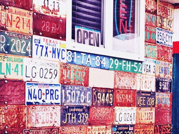
Licence plates at the Davenport Texaco
Index to this page
About Davenport, Oklahoma
Facts, Trivia and useful information
Elevation: 843 ft. (257 m). Population: 896 (2010).
Time zone: Central (CST): UTC minus 6 hours. Summer (DST) CDT (UTC-5).
Davenport is located in the central part of Lincoln County, Oklahoma. Eight miles east of Chandler, the county seat.
Davenport's History
For an early history of the region see Tulsa's History.
The town was originally a part of the Oklahoma Territory, just west of the land of the Creek Tribe and therefore was not part of the Indian Territory, however the land had been given to Native Americans by the U.S. government.
Sac and Fox Nation
The Sac and Fox are Native Americans whose original lands were located next to Lakes Huron and Michigan. The American government decided to relocate them (and all other Indians that lived east of the Mississippi) in the Indian Territories in the 1870s.
But the government later changed its mind and decided to settle the Natives, therefore they assigned each tribe member a plot of land, made them occupy it, thus reducing the land held by the tribes. The Indians had to sell the rest back to the federal government.
This surplus land (900,000 acres) was then opened to a "Land Run" by non-Indian settlers. The "run" took place on September 22, 1891 and what would become Davenport was claimed as homestsead by Noah and Annie Sutton Davenport.
The name: Davenport
The town was named after Noah and Annie Sutton Davenport, the first homesteaders.
A land run or rush was a race where the potential homesteaders set off from a starting point and rode as fast as they could to the land that was being granted, to stake their claims on the best possible places.
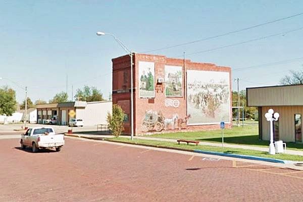
The mural on Broadway St. (see image below), depicts the 1891 Land Run.
Murals on Broadway Street, Davenport
The post office was established in 1892, and Davenport's daughter Nettie became postmistress. A community sprung up around it.
The St. Louis and Oklahoma City Railroad (later the St. Louis and San Francisco Railway or Frisco) reached the area in 1898 linking it to the outside world. The town was first platted by a local farmer, Cleason Robertson in 1900, but a year later a second railroad decided to lay a second railway across Davenport and the town moved to the point where the two railroads intersected.
The town was located on the crossing of the Santa Fe Railroad which had a north to south course, and ran on the western side of the town, and "Frisco" which crossed it from east to west on its southern side. Two small stops were located close to Davenport: Daggett, to the west and Chuckaho to the south.
Davenport incorporated in 1906 and had reached 512 residents when Oklahoma became a state of the Union in 1907.
Davenport lobbied to be on the main road to link Oklahoma City with Tulsa (see Ozark Trail below) in 1915, and was successful. Later Route 66 would use that same alignment and Davenport would benefit from the travelers that drove down the Mother Road. In 1926 the town paved its main street (Broadway) with bricks.
Oil was discovered at Davenport in the 1920s and this lead to a population growth which peaked at 1,072 in 1930. The Spherical Tank was built at this time to store natural gas.
When the Turner Turnpike linked Oklahoma City with Tulsa in the late 1950s, traffic bypassed the town, Route 66 traffic declined and population decreased. Most of its employed residents now commute to nearby towns to work.

Accommodation, find your hotel
There are no hotels in Davenport but you can lodge in other nearby towns along Route 66
> > Book your Motels and Hotels in Tulsa or Chandler
Lodging Near Davenport
There are several hotels in the area close to this town. Alternatively you can also find your accommodation along Route 66 in the neighboring towns and cities. We list them below (listed from east to west):
On Route 66's Main alignment
Eastwards
Westwards
>> There are some RV campgrounds close to Davenport.
Davenport’s Weather
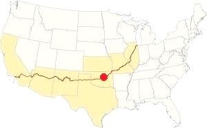
Location of Davenport on Route 66
The winter averages are: high (January) about 48°F and the low is around 27°F (8.9 & -2.5°C). The summer (July) average high and low are 93 and 71°F (34 & 21.7°C).
Temperatures of above 100°F (38°C) can be felt during summer. Summer and spring are the rainest period: annual rainfall averages 41 in. (1.040 mm) and there are some 92 rainy days every year. Around 9.5 inches (24.1 cm) of snow falls during the winter between Nov. and March.
Tornado risk
Thunderstorms may cause tornados at any time of the year, but they are more frequent during Spring and Summer. As Davenport is located inside Oklahoma's "Tornado Alley there are about 10 Tornado watches every year.
Tornado Risk: read more about Tornado Risk along Route66.
Map of Route 66 through Davenport OK
The map below was published in 1924 and it shows the first highways that were suitable for cars in Oklahoma. Route 66 was created in 1926 and aligned along the main route from Miami through Tulsa, to Oklahoma City.
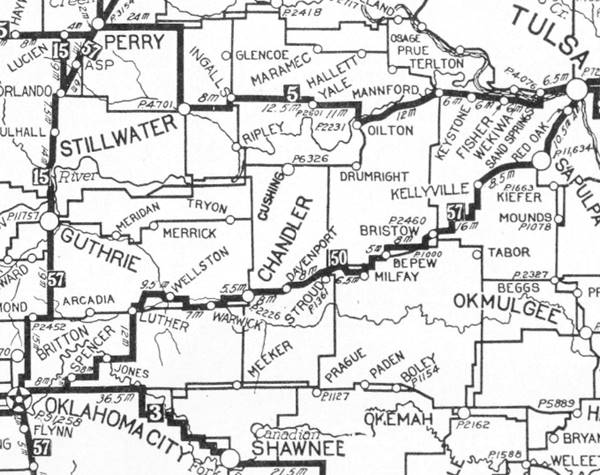
Davenport is in the middle, and Tulsa on the upper right side. The highway marked as "50" (in a black square) meaning the "Ozark Trails" would mostly become Route 66. You can follow it from Tulsa, through Chandler and westwards to Oklahoma City.
According to ODOT, the "1923 Auto Bluebook" and the Ozark Trail followed the alignment shown in this map, around Davenport, and maybe Route 66 did so until it was paved.
Route 66 was paved in 1930, and shortened and strightened out at the same time. See this post-1930 map of Route 66 in Davenport.
Route 66 Alignment near Davenport
Visit our pages with old maps and plenty of information of the old US66 roadway.
- Chandler to Yukon (next)
- Tulsa to Chandler (Davenport's)
Route 66 landmarks & attractions
Davenport Route 66 sights
Historic Context, Davenport in 1946
Jack Rittenhouse mentions the town in his "Guidebook to US. Highway 66" that he wrote after completing the trip along Route 66 from Chicago to Los Angeles in 1946.
DAVENPORT... gas; cafes; small garages; small business district; no overnight tourist accommodations. Rittenhouse (1946)
He added that oil derricks lined Route 66 on the eastern side of the town.
We will tour the town from east to west, coming from Stroud. The derricks are all gone but there are oil pumps (pumpjacks) in the fields. Head along the Ozark Trail to visit the first "ball shaped tank in Oklahoma".
Ozark Trail Section
Lincoln county authorities campaigned during the early 1910s to have a branch of the Ozark Trail system pass throug Davenport. In 1916 the Trail was aligned close to the town linking it to Stroud and Chandler.
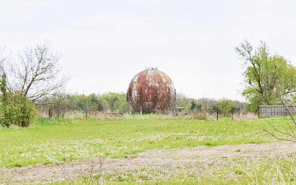
The original Ozark Trail and perhaps the first 1926-30 Route 66 alignment through Davenport was the Ozark Trail "Dogleg", and it can still be driven. At the point where OK-66 curves towards the southwest to approach Davenport (taking the 1930 US66 alignment), keep straight and head west along E0890 Rd A gravel-dirt surfaced road (map). Along this section you will see, to the right, on the north side of the road, a "Spherical Tank" the first of its kind in Oklahoma, dating back to 1925.
Spherical Storage Tank
Visible on the north side of E0890Rd just before its junction with paved N 3503 Rd. It was built by Magnolia Oil. Co., as a natural gas storage tank in 1925. It is said to be the very first round steel tank built on an oil field in the whole world.
Gas and oil were discovered in Davenport in 1924, and the tank was used to store the natural gas instead of flaring it (controlled burn).
Spherical steel Storage tank, Davenport

Tammy's Cafe sign, Source
Take a right at its junction with N 3500 Rd. (Santa Fe Rd.) and head southwards into the town where you will meet OK-66 again and its 1930 alignment
In 1930 US 66 was improved and was paved from the Creek County Line to Chandler with Portland Concrete. The exception was 1.6 miles through the town of Davenport which was paved the following year with asphalt and in 1933 rebuilt in Portland concrete.
Tammy's Cafe
Head west along Route 66 (right), ahead, facing North Park, to your right is a restaurant, formerly Gar Wooly's 66 Cafe, now it is Tammy's Round-Up Cafe (1023 North Broadway - Route 66)
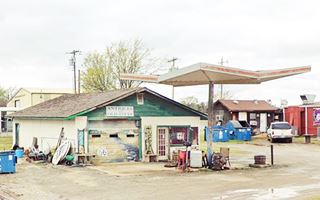
Former Gas station now Antiques store
Next to the cafe, is Rustic Sisters, two friends that found and sold antiques and "rustic junk" in an old gas station. Now they no longer sell retail but host estate sales. The gas station looks like a home, with a gabled roof building, office to the right and garage bay to the left (a nice mural is painted on its door). The detached canopy over the pump island has a single steel pole supporting a square inverted pyramid canopy head.
Early Bird Cafe
There are more unnamed Route 66-era buildings along the highway, the vacant Early Bird, to your right is one of them, with a fading and flaking sign where you can read its name and "Breakfast & Lunch".
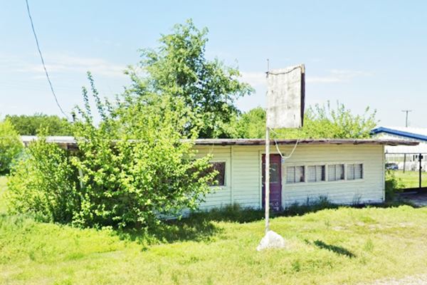
Ahead, to your left, is another former gas station or garage, until recently it was "Bill's Auto Parts", now it seems to be a home (street view), ahead is the site of a now razed cottage style gas station.
Magnolia Service Station (Gone)
To your right, at Broadway and 8th St. on the northern side of Route 66's curve as it leaves Davenport to head west, once stood a very rare building: an original wooden frame service station.
As you can see now (2021 street view), it has been razed and a new building has been built on the site.
As most filling stations of those days, it was designed in a "Cottage style" with a steep gable roof, to reassure travelers and make them feel at home. It was built by Magnolia Oil Co. around 1929. Below you can see what it looked like in 2019, before it was torn down, the garage bay to the left was built with concrete blocks.
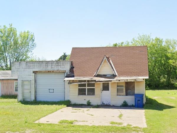
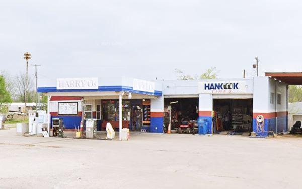
Ahead, as Broadway and Route 66 split, there is a "welcome" sign and two gas stations.
Harry O's Station
To your left, an oblong box station, still selling gas. Formerly a Shamrock station. With a flat canopy and two service bays.
Welcome Sign
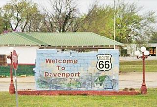
At the "Y" of Broadway, 7th St and Route 66 is the Welcome to Davenport sign and mural (see picture), with some of the local sights and a US Highway 66 shield.
Texaco Service Station
Just ahead, to your left, at Route 66 and Broadway at 7th St.
At 615 Broadway, on the left side of Route66's curve is a refurbished 1933 Texaco station. It has a hipped canopy covering the filling bay that is supported by a solid single central column. Both canopy and the building ar linked b a low steel sheet hip-roof.
The original layout had a service by on each side of a central office and shop. The one to the left was closed in, and the wall is decorated with vintage license plates from different states.
Original pumps stand on the islands and the building until recently housed the "Early Bird Diner" (moved here from their previous premises on the north side of town).
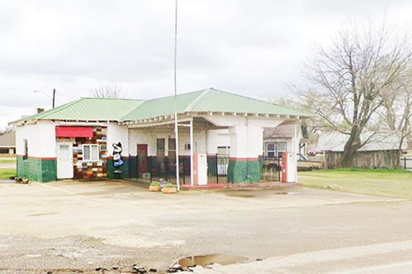
Head into the "downtown" district along Broadway. To see the murals and the "red-brick paving".
Mural on Broadway
The Farmers Bank Building dates back to 1905 and stands on the intersection of Main and Broadway in Davenport. It is a typical two story, red-brick Commercial style building. On its south face is the mural, or better said, the murals:
There are several paintings on the wall that depict a stage coach, Postmistress and first settler's daugher Nettie Davenport and a reproduction of the "Land Run" from Harper's Weekly magazine, September 1891 issue, the "Second Land Run Oklahoma".
It is said to be the tallest mural on Route 66: 32 feet (9,76 m) tall.
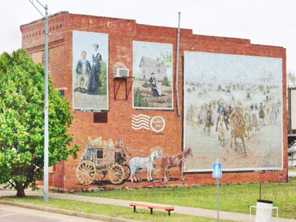
It is not the only one, there are three more murals ahead: Mural #2, Mural #3, and Mural #4, all of them along Broadway.
Brick Paved Street
To your left, between Main and 2nd St on Broadway, Davenport, OK.
Listed in the National Register of Historic Places
When Route 66 was commissioned in 1926 traffic through the town increased and the local government paved the Main Street with vitrified bricks. These were made locally by the Davenport Brick & Tile Company.
It originally ran from the Frisco tracks to te north side of the town on Sixth St. along Broadway. The width of the brick paving varies between 30 and 72 feet. The bricks are of a uniform size measuring 2.4 by 4 by 8 inches, and they are set in sand. There is a concrete apron five ft. wide at each curb. At the intersections the bricks were laid with a decorative feature, forming an X centered in the middle of the intersection.
Brick paving was popular in the early 1900s and many streets still have them in Oklahoma: Covington, Davenport, Shawnee, Chandler, Guthrie, Texoma, and Bristow, among others.
> Read more about Brick paved sections of Route 66.
The Main Street is known as "Snuff Street", and the reason is that at each street crossing there were dips which made the cars "take a dip" every block.

1936 map of Davenport. Source
Retrace your steps to Route 66 and head west, here, just past the curve was a viaduct that carried Route 66 over the old tracks of the Santa Fe railway. The tracks are gone, and the viaduct was removed in 1993. You can see it in the map (published in 1936), middle of the map left of the US66 shield.
Head west and continue your Route 66 road trip in the next town: Chandler
Some sponsored content
>> Book your Hotel in Tulsa

Credits
Banner image: Hackberry General Store, Hackberry, Arizona by Perla Eichenblat
Jack DeVere Rittenhouse, (1946). A Guide Book to Highway 66
Davenport Broadway Brick Street, registration Form, NPS
History of Davenport, www.davenport.org
Linda D. Wilson, Davenport, Encyclopedia of Oklahoma History and Culture


