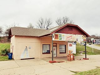
Historic Route 66 in Chandler
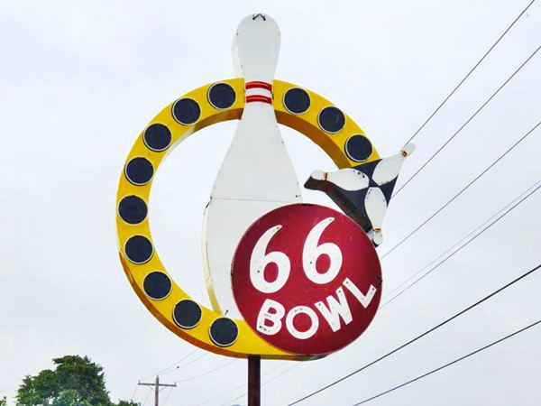
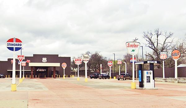
Original 1950s neon sign Route 66 Bowl
Index to this page
About Chandler, Oklahoma
Facts, Trivia and useful information
Elevation: 942 ft. (287 m). Population: 3,100 (2010).
Time zone: Central (CST): UTC minus 6 hours. Summer (DST) CDT (UTC-5).
Chandler is the county seat of Lincoln County, Oklahoma, and it is located in its center.
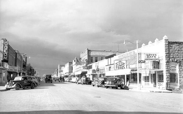
A view looking along Route 66 (Manvel Ave.) in 1940
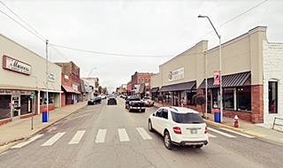
The exact same spot nowadays on Manvel Ave. in 2021.
Chandler's History
Central Oklahoma has been inhabited for over 10,000 years, but its current mix of Native Americans is the outcome of the U.S. government's policies during the 1800s. At that time the federal government decided that the Natives should cede their ancestral territories in the east and move west of the Mississippi River. This process began in the 1820s and relocated many tribes from Alabama to Ohio and the final outcome was that these "newcomers" settled in the Indian Territories (which would later become the state of Oklahoma), in lands that were given to the tribes in exchange for their original homeland.
Sac and Fox Nation
The Sac and Fox are Native Americans whose original lands were located next to Lakes Huron and Michigan. The American government relocated them in the Indian Territories during the 1870s.
Some tribes which were native to Oklahoma were displaced by the forced migrants, like the Osage people, who had to leave Oklahoma for Kansas and return later after buying back their land from the Cherokee.
But the policies changed again in the late 1800s and, prompted by the need to settle the west, the authorities decided to regain control, eliminate the Indian Territories and the autonomy that had been granted to the Indians was revoked. The State of Oklahoma was created in 1907 and the Indians became "ordinary" citizens.
It is in this context that we can understand the early history of Chandler.
The area which would become Chandler was just west of the land of the Creek Tribe and the Indian Territory, however the land had been granted to the Sac and Fox people by the U.S. government.
Land Run
A "Land Run" (or rush) was literally a race where the potential homesteaders set off from a defined starting point and rode as fast as they could to the land that was being granted and they had to stake their claims on the best possible places on a "first come, first served basis".
As part of the later process to curtail Indian autonomy the government assigned each tribe member a plot of land and bought back from the tribe the surplus land.
This generated a large surface of vacant land (900,000 acres) which was then opened to a "Land Run" by non-Indian settlers. The "run" in Chandler took place in September 1891 on territory opened for settlement which had belonged to the Sac and Fox people.
Prior to the run, Chandler's townsite was chosen deliberately: it was in the center of the future county (named "County A" at that time) and was next to a spring of water (now in a city park). The post office opened on Sept. 21, 1891.
The Name, Chandler
The town was named for Assistant Secretary of the Interior George Chandler, of Kansas, who served under President Harrison (1889-1893).
The name is similar to the word "Candle" and in fact the surname originated from the "Chandler", the person who was the head of the chandlery in medieval households and was responsible for wax, candles, and soap.
A general election was held on November 8, 1892 and the county received its current official name: Lincoln.
The railway (St. Louis and Oklahoma City Railroad - which later became "Frisco" or the St. Louis and San Francisco Railway) reached the town in 1898 and allowed it to ship out cotton and bricks from the Chandler Brick Factory. Cotton was an important business in the early 1900s and cottonseed oil was produced in Chandler, so were pecan nuts and fruit.
Historic Phillips 66 station, Chandler
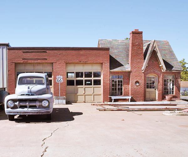
In 1926 US 66 was aligned along Chandler's Main Street and brought a steady flow of travelers and boosted the local economy. Population has been fairly stable, it was 2,234 when Oklahoma became a state of the U.S.A. in 1907, and now stands at 3,100 residents.
Pecan Capital of the World
In 1949, the Oklahoma legislature declared Chandler as "The Pecan Capital of the World"
Chandler's Main Street was bypassed by the Turner Turnpike which linked Oklahoma City with Tulsa in the late 1950s,
The last old-west gunfight in Oklahoma
The last gunfight took place in Cromwell, Seminole Co., 33 miles southeast of Chandler and it ended up with the death of a veteran lawman and gunfighter of the American Old West: William Matthew "Bill" Tilghman.
Tilghman (1854 - 1924) began his career as a buffalo hunter at the young age of fifteen. In 1878, he was approached by Bat Masterson to serve as a deputy sheriff and he took the job and held it until 1884. He took part in the 1889 "Battle of Cimarron" and later worked as deputy US Marshal, imposing the law and order in the Indian Territory of Oklahoma.
He was elected sheriff of Lincoln County in 1900 and was based in Chandler. He retired as a US Marshal in 1910 and was elected to the Oklahoma State Senate. He was also police chief of Oklahoma City.
In 1924, although he lived in Chandler, he took the job as marshal of Cromwell where a corrupt Prohibition Agent, Wiley Lynn shot him to deat in the street.
He is buried in Chandler, where a city park is named after him. In 1960, he was inducted into the Hall of Great Westerners at the National Cowboy and Western Heritage Museum in Oklahoma City.

Getting to Chandler
Heading east from Chandler along US. hwy 66 are the towns of: Davenport (7 mi.), are Stroud (13 miles), Depew" (24 mi), Bristow (33 mi). Further east is Tulsa.
To the west, are Warwick (7 mi), and, 48 mi. away, Oklahoma City.
Where to Stay: Find a hotel in Chandler
Book your lodgin in Chandler
> > Book your hotel in Chandler
Lodging Near Chandler along Route 66
There are several hotels in the area close to this town. Alternatively you can also find your accommodation along Route 66 in the neighboring towns and cities. We list them below (listed from east to west):
On Route 66's Main alignment
Eastwards
Westwards
>> There are some RV campgrounds close to Chandler.
Chandler’s Weather
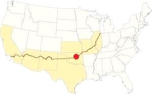
Location of Chandler on Route 66
Chandler's summers have highs that average 94°F or 34.5°C (July) and lows of 70.9°F (21.6°C). The winter (Jan) averag highs are 48.6°F (9.4°C)and the average lows are below freezing at 25.7°F (-3.5°C). The average annual precipitation is 35.2 inches (895 mm) and most rain falls during May, June and September (5.3, 4 and 4.3 in respectively - 135, 100 and 109 mm).
There are about 90 rainy days per year, and during summer, thunderstorms take place with hail and potential tornado formation. About 9.5 inches of snow (24 cm) fall during winter, as early as November and as late as March.
Tornado risk
Chandler destroyed by the 1897 tornado
The fledgling town was hit badly by a tornado on March 30, 1897 that killed 19 people, wounded hundreds and razed the town. It was rebuilt with sturdier brick and stone buildings of which several are now listed as Historic Places.
It is located in the infamous "Tornado Alley and it has around 10 Tornado watches every year.
Tornado Risk: read more about Tornado Risk along Route66.
Map of Route 66 in Chandler, OK
Chandler's county officials worked hard to have the main road between Oklahoma City and Tulsa pass through the town. And were very successful: the network was defined in 1915, and went through Chandler.
The same route would become Oklahoma Highway #7 and in 1926, it became part of the brand new Route 66.
The map below shows these first highways. It was published in 1924, only two years before Route 66 was created.
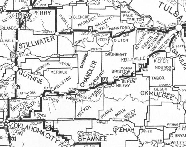
Chandler is in the middle, and Tulsa on the upper right side. The highway marked as "50" (in a black square) meaning the "Ozark Trails" would mostly become Route 66. You can follow it from Tulsa, through Chandler and westwards to Oklahoma City.
This is the Route 66 in Chandler.
Route 66 Alignment near Chandler
Visit our pages with old maps and plenty of information of the old US66 roadway.
- Chandler to Yukon (next)
- Tulsa to Chandler (previous)
Route 66 landmarks & attractions
Sights in Chandler
- City tour of Chandler (read below)
- Tours & Itineraries
- State Parks
Historic Context: Chandler in 1946
Jack Rittenhouse mentions Chandler in his "Guidebook". He wrote it after driving the whole of Route 66 from Chicago to Los Angeles in 1946.
CHANDLER... Grace Hotel; LaGere garage; courts: Lincoln, Chandler; all facilities Rittenhouse (1946)
He added that Bill Tilghman's grave was in the local cemetery.
Chandler City Tour & Attractions
We will tour the town from east to west, coming from Davenport. The first sight is a new one, a bowling alley with great signs.
Route 66 Bowl
The bowling alley to your right at 920 E 1st St, has an original neon sign (pictured at the top of this page), and plenty of classic gas station signs in the parking area in front of the building, Sinclair, Gulf, Standard, Tydol, Apco, and more.
They reused the original neon sign from the now-gone "66 Bowl" of Oklahoma City, that opened in 1959 and closed in 2010. The sign was auctioned in 2010 for $3,900 (Street view of sign in OKC in 2007). Now it is back again on Route 66.
Drive west and ahead, to your right is the Lincoln Motel.
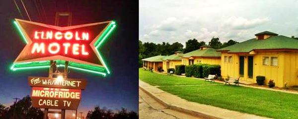
The Lincoln Motel
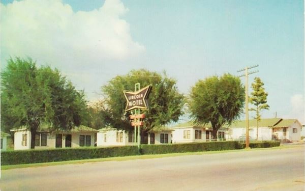
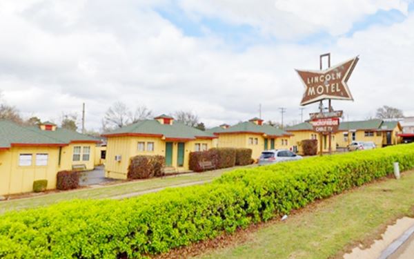
740 E 1st St, Chandler. The motel is a typical example of the cottage-style rooms frequent in vintage Motels along Route 66.
This Route 66 icon was built in 1939 and now includes a retro-looking neon sign.
The postcard below ca.1960 reads "Phone 200 Located on East edge of Chandler Highways 66 and 18 Free TV - Refrigerated Air - Thermostat Controlled Heat - Playground for Children - Truck Parking in Rear - Restaurant Next Door". Below is a "Then and Now" sequence, the trees have gone, but the rest is the same.
Ahead Route 66 curves and takes a north-south course. To your right, at the curve is the Historic Armory.
The Chandler Armory
At the Junction of Mickey Clarkson Ave & 1st St. 400 East Route 66, Chandler, OK.
Listed in the National Register of Historic Places
An armoury built in the mid-1930s and reconverted into a Route 66 Interpretive Center.
It is an armory, a military building (arsenal) used for the storage of arms and ammunition, built by the Works Progress Administration (WPA) between 1935 and 1937. The WPA was set up to use local resources and employ local labor during the harsh years of the Great Depression. It employed over 250 workers and was an important boost to Chandler's economy.
Bryan W. Nolan a local architect and National Guard officer designed it as a solid building with local red-colored sandstone walls, built to withstand tornadoes. It housed offices, locker rooms, ammunition vault, drill hall and a rifle range and was used as quarters for 58 men and five officers of the Oklahoma National Guard which later saw action during World War II.
Chandler Route 66 Interpretive Center
In 1971 a modern facility replaced the old armory and it was deeded to the town of Chandler. It fell in disrepair but after being listed in the National Register of Historic Places in 1992, it was carefully restored. It reopened in 2007 to house the "Chandler Route 66 Interpretive Center" with exhibits of vintage Route 66.
More information at the www.route66interpretivecenter.org website.
Into Chandler
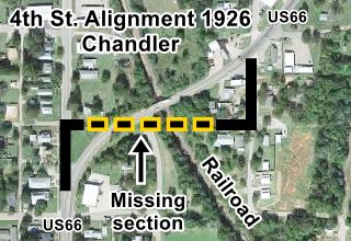
Route 66 follows a curved alignment built in the 1920s across what then was a park and open countryside. The original highway went south along S. Cleveland Ave., then west along 4th Street. where it crossed the railroad on a bridge during 1926. The following year a new viaduct was built next to it (on Mickey Clarkson Ave.) replaced it. The old bridge was removed and Route 66 adopted the current alignment. The 1927 viaduct was replaced by the present one in 1956. See map below.
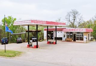
1970s Texaco
At the curve on the eastern side of the bridge, at 222 Mickey Clarkson Ave., to your right, you can see a 1970 mansard roof gas station with shingles on the canopy and building. Maybe a Texaco, as they used this style at that time (pictured above).
Head south along Route 66, named Manvel Ave., on the western side of the railroad. Two blocks ahead, at Manvel Ave and 7th you will see two ancient gas stations.
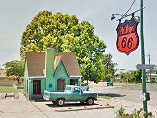
Historic Chandler Phillips 66 Station
To your right, on the SW corner at 701 Manvel Ave., Chandler, OK.
Listed in the National Register of Historic Places
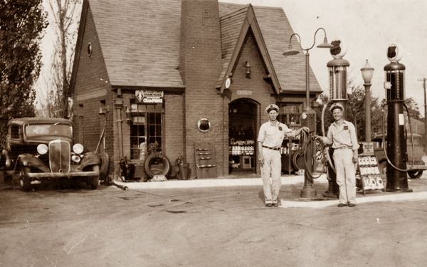
A cottage style Phillips 66 gasoline station built in the early 1930s, numbered #1423.
Like many Phillips 66 Stations of the early 1930s, it was built in bricks a Tudor Revival cottage style, the steep gabled roof, tall windows and chimney (notice letter "P", logo on the chimney) conveyed a home-like look to reassure the travelers and make them feel welcome. Over 300 buildings like this were built by Phillips between 1928 and 1945 and many survive along Route 66.
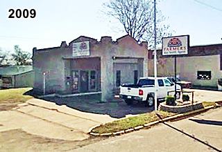
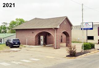
Across Manvel Ave., on the SE corner is a solid brick building with a massive gable roof over a drive-in area. Now it is an insurance company, but until recently this was a gas station.
Former Sinclair station
It originally had (see image below from 2009) a style used by Sinclair from 1930 to c.1940, a Spanish Ecclectic or Mission styling. A flat roof building, with service bays on the side of the office, a flat canopy held up by large corner columns, pent roof parapets and pedimented parapets on the canopy, with tile decoration.
Now it has a solid brick structure with a gable roof (2021 image below).
Halfway down the block, to your right is the stone faced "Mascho Building", built by A.E. Mascho in 1898, the year after the 1897 tornado razed Chandler. He used it for his grocery store. It operated as a store until the mid 1970s, when it became the Lincoln County Historical Society Museum.
Lincoln County Historical Society and Museum of Pioneer History
719 Manvel Ave., Bristow OK.
Exhibits of the artifacts and photographs of the town and its residents, from the days that preceded the Land Run of 1891, onwards. Visit their website: www.okpioneermuseum.org for more information.
Crane Motor Company Building
Across Manvel, on the NE corner with E 8th at 722 Manvel Ave., Chandler, OK.
Listed in the National Register of Historic Places
A vintage automobile repair and sales shop of the early 1930s. Clyde Crane and L.P. Anderson owned it. It was a
garage to service Fords. Unlike many similar shops, it was not a reconverted blacksmith shop, instead it was specially built for cars.
It had large windows to display the cars it sold. It is a two-story building in brick and sandstone, the original windows and doors have been filled in.
Head west. On the SW corner of Route 66 and W 11th is a possible gas station with the building angled towards the corner and a solid brick crenellated canopy held up by three sturdy columns and inlaid with white rectangles. Now it has been painted over with murals and the parking area under the canopy has a low wall enclosing it. See a past street view.
Facing it, to your left is another Phillips 66 station.
Another Phillips 66 station
On the SE corner of Manrel Ave and E 11th. The former office has been walled in, removing the slanted plate glass windows (see inset in image below and 2009 street view). The pump island and the two service bays to the right are still there and also the stone (rock) wall that gave this type of design its name: Rock Frame stations. They were adopted by Phillips 66 in the early 1950s.

As you reach the next corner, to your left is another 1950s gas station. Two service bays, gas pump island under a slightly angled flat canopy and a corner office. See its street view.
On the next block is the old St. Cloud hotel.
 />
/>
St. Cloud Hotel, click for St. view
St. Cloud Hotel
 />
/>
Ghost sign on the St. Cloud Hotel, click for St. view
1216 Manvel Ave., Chandler, OK.
Listed in the National Register of Historic Places
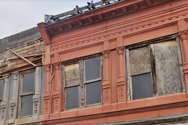
A classic hotel established in 1903, slowly falling apart.
The hotel was built by John E. Gromley, a grocer and lumberman who bought the lots in 1903 for his hotel. In 1904 he added to more lots to his property, known then as "Gromely's block".
He operated a saloon (Silver King Bar) until statehood, when the new constitution banned the sale of alchol in Oklahoma (1907).
Salesmen traveling by train used the hotel and, when Route 66 was created in 1926, it catered to those traveling in cars. It has two-floors built in brick and sandstone.
Notice the tin cornice and facade on the second story (pictured below). There is also a Coca Cola ghost sign on its side wall; A ghost sign is a genuine hand-painted advertisment from decades ago, that has survived on a building for a long time, and hasn't been removed or painted over (see picture).
In the 1920 Sandborn map you can see the hotel and the armory that in those days was housed in the 1st floor of the nortern wing of the building.
Bakery that was a gas station
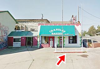
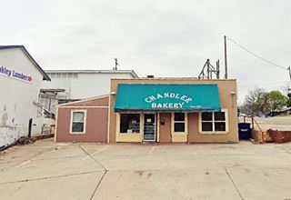
Ahead, to your right, on the SW corner of Manvel Ave and E 13th St. is a bakery that until recently still had its original concrete pump island, you can still see its outline in the parking space in front of the building. Below is a "Then and Now" sequence.
Just ahead Route 66 turns sharply to the right, a 90° curve to head west. Here are two classic US66 buildings.
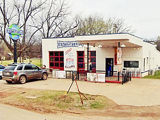
Destinations, former filling station
To your left. Now it is a restaurant. They neatly repurposed the gas station. It had a flat canopy over the corner office and two service bays to the left. We couldn't find out what gasoline brand it sold. Pictured below.
Douglas Grocery store
Facing the service station, to your right, on the NW corner at the curve is Douglas' Grocery store. It was a gas station. The one-floor brick building has a pump island (the pump on it, is very ancient and maybe an original one). The sevice bay to the left was walled in. The roof and the gabled canopy aren't original either.
Around the corner, just ahead to your right, where the gas sation is now located once stood Gibson's Court, a motel with a gas station.
Your city tour along Route 66 in Chandler ends here.
Tours & Itineraries
"Meramec Caverns" Barn
Head west along Route 66, 3.6 miles west of junction of W 15th St. and Manvel (map with directions).
On the south side of the highway is a barn which is painted with an advertisment promoting the "Meramec Caverns". It is the last one remaining in Oklahoma.
Meramec Caverns were actively promoted by Lester B. Dill, who actually invented the bumper sticker as a means of advertising them. He erected billboards along Route 66, and also, painted barns.
Considering that the Meramec Barn advertisement is over 400 miles away from the Caverns, the advertising was done on a grand scale. See other examples of barn signs on Route 66 in St. Clair and Conway, both in Missouri.
Meramec Caverns
It is a vast cavern system with 4.6 mi (7.4 km) of caves. They are located next to Route 66 in near Stanton, Missouri; (Read all about it: Meramec Caverns).
It began to be promoted to the public as a tourist attraction in 1935 and became one of the main attractions along the old US Highway 66. Today it is visited by over 150,000 tourists every year.
Drive west along Route 66 and continue your road trip in Warwick
Natural Attractions
The town has two small lakes and a municipal park: Tilghman Park, at 1015 Joe Long Drive. More details at the park's website
Bell Cow Lake has RV campsites and Chandler Lake has a primitive campground.
Some sponsored content
>> Book your Hotel in Tulsa

Credits
Banner image: Hackberry General Store, Hackberry, Arizona by Perla Eichenblat
Jack DeVere Rittenhouse, (1946). A Guide Book to Highway 66
Sally Bourne Ferrell and Donald F. Ferrell Chandler, Encyclopedia of Oklahoma History and Culture


