Historic Route 66 in Wellston OK
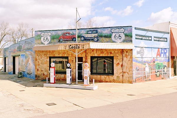
Vintage 1920s Filling Station
Index to this page

TheRoute-66.com is reader-supported. When you buy through links on our site, we may earn an affiliate commission at no additional cost to you.
About Wellston, Oklahoma
Facts, Trivia and useful information
Elevation: 899 ft. (274 m). Population: 788 (2010).
Time zone: Central (CST): UTC minus 6 hours. Summer (DST) CDT (UTC-5).
Wellston is just 12 miles west of Lincoln County's seat, Chandler, in the central western part of the county.
This area has been inhabited for more than 10,000 years however the contemporary Native American populations were transplanted there during the 1800s from their original territories east of the Mississippi River. The U.S. government relocated (removed) Indians from Illinois, Ohio, Florida and Alabama and resettled them in the Indian Territories (which would later become the state of Oklahoma).
Wellston is on the land that was ceded to the Kickapoo group as a Reservation (The Kickapoo were originally from Illinois). However the government later changed its mind and made the individual tribe-members receive a plot of land and then had the tribe sell the surplus land back to the federal government. This created over 900,000 acres of surplus land which were "opened" to settlement through the method of "Land Runs". The run in Wellston took place in 1895.
But the first settler, Christian T. Wells arrived earlier. He opened an Indian Trading Post in the Kickapoo Reservation in 1880. Later, in 1884 the post office was established, and Wells was the postmaster.
The Name: Wellston
The town was named after the first settler, Christian T. Wells.
Land Run
A "Land Rush" or "Land Run" was a system by which those interested in staking a claim for a plot of land set off from a starting point and rode as fast as they could towards the land being "opended" to settlement. Once they reached it, they claimed their homestead on a "first come, first served basis". There were several "runs" in the early 1890s in Oklahoma.
Thomas Craddock claimed the land near Well's trading post and deeded land for a town which was laid out next to where Captain Creek joined Deep Fork River. A road soon linked it to Chandler an Oklahoma City, and in 1898 the Arkansas and Oklahoma Railroad, (later the St. Louis and San Francisco Railway or "Frisco") reached the town and built a station there.
Cotton farming was the main activity. During the early 1900s, the county successfully lobbied to have the "Ozark Trail" pass through it, and by 1918, the dirt surfaced trail passed through the town. It later became Oklahoma State Highway No. 7 and as such was incorporated into the alignment of Route 66 when it was created in 1926, which passed right through the town for the next six years.
There was quite a controversy about the alignment of Route 66 through Wellston: the Wellston Loop and Gap issue reaching Oklahoma's Supreme Court in 1932. But basically, US 66 did not enter the town when it was upgraded in 1933, it bypassed it.

Getting to Wellston
Heading east from Wellston down Route 66 are the towns of: Warwick (4.3 mi.), Chandler (12 mi.), Davenport (19 mi.), are Stroud (25 miles). Further east are Depew" (36 mi) and Bristow. To the west, are Luther (8.5 mi.), Arcadia (16 miles) and, 36 mi. away, Oklahoma City.
Where to Stay: Hotels Near Wellston
Book your hotel in neighboring Chandler or Edmond
>> Book your Hotel in Chandler or Edmond
Lodging Near Wellston along Route 66
There are several hotels in the area close to this town. Alternatively you can also find your accommodation along Route 66 in the neighboring towns and cities. We list them below (listed from east to west):
On Route 66's Main alignment
Eastwards
Westwards
>> There is an RV campground in Wellston.
Wellston’s Weather
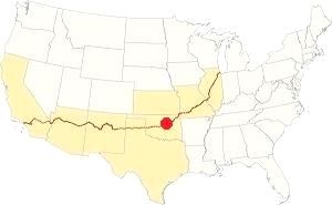
Location of Wellston on Route 66
The average highs during summer are around 94°F or 34.5°C (July) with lows of about 71°F (21.5°C). Winter in Wellston has average highs (Jan) of around 48.5°F (9.2°C) and average lows are below freezing: 25.6°F (-3.5°C). The average rainfall is about 36 inches (914 mm). Most of it falls during May, June and September: 5.5, 4 and 4.3 inches (135, 100 and 109 mm) respectively.
There are approximately 90 wet days every year. Thunderstorms with hail and strong winds are more frequent during summer and may spawn tornados. During the period spanning November to March, some 9.6 inches of snow (24 cm) fall.
Tornado risk
Wellston is located in the "Tornado Alley! and experiences around 10 Tornado watches every year.
Tornado Risk: read more about Tornado Risk along Route66.
Map of Route 66 alignment in Wellston

1948 Shell Roadmap central Oklahoma
Click on map to enlarge
Source
See Route 66 in this 1948 roadmap (click thumbnail for full size map). There was no Interstate system in those days. Wellston is on the upper right side of the map which shows both "Gap" and "Loop" alignments.
Below we describe the Gap and Loop segments of Route 66 in detail.
Route 66 ran by Wellston from 1926 till it was decertified in 1985.
Route 66 Alignment near Wellston
With old maps and all the information of the old roadway.
- Yukon to Clinton (next)
- Chandler to Yukon (Wellston's)
- Tulsa to Chandler (previous)
Route 66 landmarks & attractions
Sights in Wellston
Jack Rittenhouse mentions Wellston in his "Guidebook" written after he drove Route 66 from Chicago to Los Angeles in 1946.
WELLSTON is a small community located about one mile north of here. At the crossroads is the Pioneer Tourist Court, with a gas station Rittenhouse (1946)
We will tour the town from east to west, coming from Warwick. After passing under the Interstate, to your right is what remains of the motel mentioned by Rittenhouse back in 1946.
Pioneer Tourist Court
Just east of the junction of Route 66 (OK-66) and OK-66B and S 3340Rd, 1⁄5 of a mile after crossing I-40, on the right side of the road.
The building was built with roughly hewn brown sandstone; it was the gas station. Now it is vacant, and the tourist camp behind it closed long ago.
The "Then and Now" sequence below show how the building has changed over the years. Notice the round stone pillars that held up an entrance arch (red arrows).
The building once housed a restaurant that closed in 2017 after a fire, yet still reads "Pioneer B.B.Q", it was ran by the Bouska family. The adjacent "Butcher's Barbecue Stand" belongs to the grandson of the old restaurant's founder.
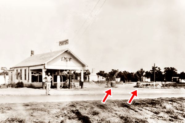
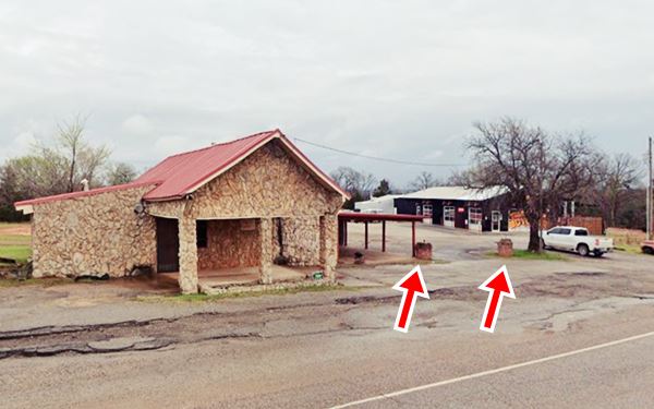
Concrete totem pole (gone)
In its day was bustling with travelers and boasted a totem pole with "marble-eyes" which has vanished.

Detail, Concrete totem pole, Source and large image
The Oklahoma Route 66 Scenic Byway Corridor Management Plan (CMP) published in 2008 and revised in 2010, mentions a "Concrete Totem Pole (Segment 4, Map ID #67). The historic Concrete Totem Pole is located in Wellston at the Pioneer Camp BBQ. The Pioneer." We have been unable to find it now, but you can see it in this street view (2008) as a white line on the left side of trunk of the tree that stood on the eastern (right) side of the property. The tree has also been cut. We are sharing a thumbnail of the totem pole (see image) so you can see what it looked like.
Just ahead, there is a fork in the highway. To the right is the original alignment of Route 66, from 1926, now it is OK-66B: the "Loop" alignment. The later Route 66 "Gap" alignment keeps on straight, heading west.
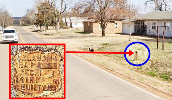
Route 66 F.A.P. marker
Turn right and follow the "Loop" by driving along OK-66B and head towards Wellston. Just ahead, 0.7 miles north is an old concrete marker.
The metal shield embedded in the post reads "OKLAHOMA F.A.P. 137 SEC. B LGTH. 5.44 MI BUILT 1928" (see image below) this was built by H.L. Cannnady Co. and included 0.784 miles along SH66. The Federal Aid Program (FAP) covered grade & drain, base rock asphalt surface.
Ahead the road curves to the west, becoming 2nd St. in the "downtown" district. Here, to your left is a mural.
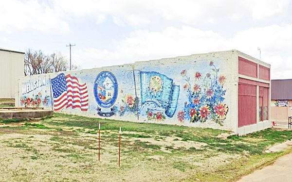
Wellston Mural
Painted on the wall facing east of an old red-brick building on the SE corner of 2nd and Birch St.
Ahead, to your right, on the NE corner of Cedar St. is an old gas station.
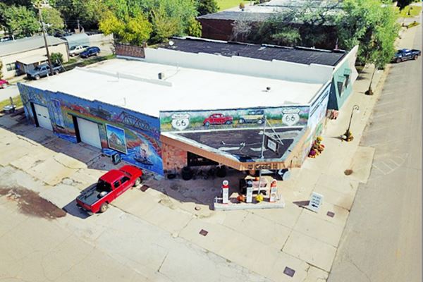
Cecil's gas station
Facing the corner, with service bays on Cedar. It has a flat trapezoid shaped canopy over the single pump island. The walls have been decorated with colorful Route 66 murals and three vintage pumps of different brands have been mounted on the pump island. Neat and nice.
Keep westbound follow 2nd Street which curves towards the SW as it leaves the downtown area. Just west of Wellston is Captain Creek with its historic bridge.
Captain Creek Bridge
Route 66 and Captain Creek, Wellston, OK.
Listed in the National Register of Historic Places
This is an original bridge built in 1933 on the "Loop" through Wellston in the middle of the controversy over the alignment of Route 66.
The steel bridge measures 225 feet long between abutments and the central span is 100 ft. long. The roadbed is 20 ft. wide and the total bridge widht is 22 ft.
Captain Crek Bridge on the "Loop" of Route 66 in Wellston, Oklahoma
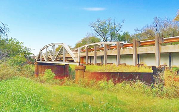
It is a camelback pony truss bridge mounted on concrete piers and carries the "Loop" segment of Route 66 across Captain Creek.
The name "camelback" comes from the shape of the trusses (those steel triangular frames on each side of the bridge are trusses), the structure curves and forms an arch-shaped truss (like a camel back), it is both strong and light.
The "pony" part refers to placement of the traffic in relation to the structure: traffic flows between the parallel trusses that are open (not braced at the top).
In 2021 the old bridge was overhauled: the Captain Creek Bridge replacement project was completed in August, and the original 1932 trusses no longer support the bridge. However, they were attached to the new deck to maintain the original historic look of the bridge.
From this point Oklahoma state highway 66B heads southwest to meet OK-66 and head towards Luther.
The two Route 66 alignments in Wellston
Why are there two alignments of Route 66 at Wellston? It is a long story.
The "Loop" and "Gap" of Route 66 in Wellston
The original road that linked Oklahoma City to Chandler and Tulsa through Wellston was built due to the efforts of a private association, the "Ozark Trails Association".
Its goals were to build a decent highway network to allow farmers to move their produce to the markets and to allow the growing number of cars to circulate along reasonable roads.
Ozark Trail
The Lincoln county authorities quickly saw the positive effects of such a network and they were very active promoting the Ozark Trails during the early 1910s. Their goal was to have the road pass through the county (and its seat, Chandler), linking it to Tulsa, Oklahoma City and the rest of the nation.
This lobbying was successful and by 1918, the Ozark Trails passed through Lincoln county and Chandler. It also passed through Wellston.
Over the following years, Oklahoma improved the road and transformed it into Oklahoma Highway No. 7. Paving some sections of it like the Ribbon Road.
When the U.S. highway system was outlined, Route 66 was placed along Oklahoma Hwy. 7 as it was the best road between northeastern Oklahoma and the state's capital city.
The Loop
In 1926 Route 66 was created and it went right through Wellston following the current alignment of OK-66B (Ash and 2nd streets). It departed from its East-to-West course on the eastern side of Wellston, looped north into the town and then again south again, to return to its original westerly course.
A few months later, a vote was cast to issue bonds to pave the road through Wellston. By 1928, Route 66 was paved in asphalt from Chandler to Wellston city limit, about half a mile north of the turnoff; the Route 66 F.A.P. marker shows the exact spot. From there westwards it was a dirt surfaced road.
Route 66's initial 10926 across Oklahoma alignment was not the best: it followed property lines and had many sharp right angle curves at the boundaries between properties. So when Route 66 was upgraded in 1930, the original zig-zag course of the "Ozark Trail" was improved and shortened.
In 1930 the road west of the Lincoln - Oklahoma County line was paved in Portland concrete. The remaining section to be paved included Wellston. But here two points of view collided: the town and state on one side and the Federal government on the other.
The Gap
The U.S. Bureau of Public Roads favored an alignment that ran half a mile south of Wellston, and wanted to pave the short distance ("Gap") between the existing ("Loop") road that entered and exited Wellston. It was shorter, and cheaper.
The town on the other hand realized that they would loose traffic and revenue if travelers took the shorter route and bypassed the town, so they lobbied for the "Loop" to be paved. So the town took the case to court and won.
The Oklahoma Supreme Court ruled in its favor but the US Bureau of Public Roads stood by its decision to bypass Wellston and paved the "Gap" just the same. But the state Higway Commission had to abide by the court order and it paved the "Loop" through the town with Portland concrete in 1932, and built the Captain Creek bridge the following year. As it was not a U.S. highway, but a state higway, it was renamed as State Highway 66, becoming the first section of road to be named as a state highway "66" between Los Angeles and Chicago (many states would follow this practice fifty years later when US 66 was decomissioned).
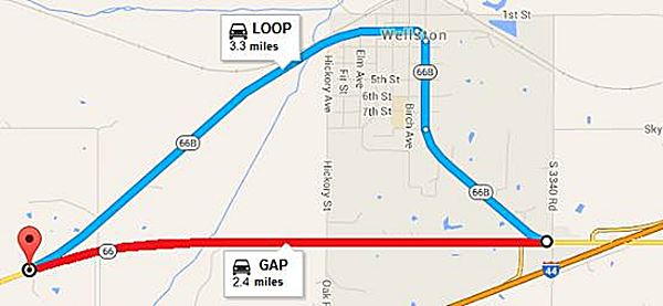
Many years later, after U.S. Highway 66 was decertified and Route 66 became OK-66, this original "loop" through Wellston or State Highway OK-66 was renamed as OK-66B.
The federal Route 66 across the "Gap" was built in 1933 and also had its own bridges across Captain Creek, it was paved in Portland Concrete all the way to the Oklahoma county line.
The town in the end failed: the loop did not manage to attract traffic through the town: in 1939 only 7 cars passed every hour through town compared to 600 passing south of the town. Route 66 did not benefit Wellston as much as it did to other towns along its alignment.
By the way, the Loop measures 3.3 miles and the Gap 2.4 miles... so it was less than one mile of road that kept Route 66 out of Wellston.
Red's Rockin' RV Park
Head west along Route 66, ahead is the Red's Rockin' RV Park. It originally opened back in 1986 as Ward's RV Park and had a large teepee and totem pole on the premises. Ward's Trading Post stood next to the highway. It closed in the 1990s. It was acquired by its current owner and restored. The photos are from their website.

Teepee at Ward's RV camp, Wellston credits

Totem pole at Ward's RV camp, Wellston credits
Your road trip through Wellston ends here, you can drive west to Luther.
Some sponsored content
>> Book your Hotel in Tulsa

Credits
Banner image: Hackberry General Store, Hackberry, Arizona by Perla Eichenblat
Jack DeVere Rittenhouse, (1946). A Guide Book to Highway 66
Town website www.townofwellstonok.com
Gerry Stanfill Greenfield, Wellston, Encyclopedia of Oklahoma History and Culture.

