Your Route 66 Road Trip through Clementine
Index to this page
About Clementine Missouri
Facts, Trivia and useful information
Elevation: 1,039 ft (317 m). Population n⁄a (2010).
Time zone: Central (CST): UTC minus 6 hours. Summer (DST) CDT (UTC-5).
Clementine is located on the 1926-1981 alignment of Route 66 in Phelps County in the central Missouri Ozarks.
History of Clementine
For the general history of the area check our page with the History of Rolla and Phelps County.
The state legislature created the county in 1857 and named it after John S. Phelps (1814-1866) congressman and state governor (1876).
Shortly after, the "Wire Road" was built as a service road for the telegraph line that linked St. Louis with Fort Smith in Arkansas and passed close to Clementine. The stage coach line passed by here and in 1867, after the Civil War, the railroad extended through Newburg, Arlington and Jerome north of Clementine, bypassing it.
A small community formed and the post office opened in 1891 (it closed in 1926).
The name: Clementine
The name is that of a girl, and comes from the Latin word "clemens": mild or mercy. i.e. Clementine = merciful. The post office was given this name for unknown reasons. It was also known as "Basketville".
The use of cars led to the creation of State Highway 14 and a bridge across the Little Piney River in 1923. This highway became Route 66 in 1926, which by 1931 was completely paved. During WW II, the route was upgraded to a four lane highway west of Clementine into Ft. Wood and, during the 1950s, Route 66 was turned into a four-lane freeway. These changes bypassed some of the town's stores and when I-44 was created, it bypassed the town.

Find your Hotel close Clementine Missouri
You can book accommodation nearby in St. Robert; it has plenty of lodging options.
> > Book your hotel in Saint Robert
More hotels near Clementine along Route 66
There are several hotels in the area close to this town. Alternatively you can also find your accommodation along Route 66 in the neighboring towns and cities in Missouri. We list them below (from east to west):
On Route 66's Main alignment in MO
Eastwards
Westwards
- Hotels in Kansas
- Baxter Springs KS
- Galena KS
- Riverton KS
- Hotels in Oklahoma
- Miami OK
>> Check out the RV campground in neighboring Waynesville
Weather in Clementine
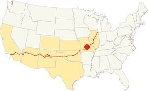
Location of Clementine on U.S. Hwy. 66
There are clearly defined seasons in Clementine. During summer, the average high (Jul) is 88°F (31.2°C), while the average low in 67°F (19.2°C). During winter (Jan) the average high is 42°F (5.6°C) and the average low is below freezing at 20°F (-7°C).
Rainfall averages 44.5 in (1.131 mm) per year and falls regularly each month in roughly the same amount). Snowfall is around 9 in. (23 cm), and falls between Dec. and Mar.
Tornado risk
Clementine is located in the "Tornado Alley" and Phelps County is hit by some 8 tornado strikes every year.
Tornado Risk: read more about Tornado Risk along Route66.

Map of Route 66 in Clementine
The village of "Clementine" appeared in the 1926 MO DOT map of US highway 66 with a "gravel" surface; it appears as a paved road in the 1933 MO DOT map.
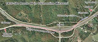
The original 1926 to early 1950s Route 66 from Powelville is shown in this map. After WWII, in the early 1950s, the Missouri Highway Department started work to improve Route 66 to make it safer and shorter, this meant eliminating its winding course in many sections.
It extended the 1943 four-lane road from Hooker (west of Clementine), eastwards to Clementine, and from there, eastwards. Two new lanes were built towards Powellville to carry eastbound traffic and the original US66
became the westbound lanes. The eastbound lanes ran separately in a straighter course, and are now buried beneath I-44. Both pairs of lanes met and ran together as a four lane highway just south of Powellville, but split again after Goodall Cemetery.
In 1967 a new set of westbound lanes were added to the freeway beside to the 1950s eastbound ones. They were built from a point just south of Powellville into Clementine.
The former westbound lanes which were the original 1926-50s Route 66 became the North Outer Road. As the new freeway was a limited access highway, the old alignment in Clementine was erased at Exit 169.
The thumbnail map (click on it to enlarge it) shows these changes.
The Route 66 alignment in Clementine
Visit our pages, with old maps and plenty of information about US 66's alignments.
- Springfield to Joplin (next)
- Rolla to Springfield (in Clementine)
- Gray Summit to Rolla (previous)
Route 66 across Missouri
Historic U.S. highway 66, "Route 66" has been designated as an All-American Road and National Scenic Byway in the state of Missouri.
Route 66 Sights in Clementine
Old "Basketville"
Historic context, the classic Route 66 in Clementine
The WPA wrote in the 1941 "Missouri, a guide to the "Show Me" state" about a community 3.3 mi. east of Hooker known as "the Ozark Basket Weavers", located on the left (west) side of the road, here the baskets were strung on wires next to the highway. The town consisted of "drab, listing shacks". The baskets were woven with cane and hickory splits and handmade. These were made by farmers who abandoned their plots and moved to Route 66 to sell their handicrafts.
In his 1946 "A Guide Book to Highway 66" Jack DeVere Rittenhouse also mentioned it; as being one mile south (west) of Powellville. He described as follows.
Clementine. Hardly a town, but chiefly devoted to small roadside stands selling handmade hickory baskets and turned wood objects made by native craftsmen Rittenhouse (1946)
Rittenhouse added that they were said to be the best in the region. He also said that the divided highway began here; Read about this four lane road built during WWII in our Hooker webpage.
Clementine and its Route 66 attractions
The "village" is barely a few scattered houses but some of its classic buildings are there (or their ruins or foundations).
Tour Clementine driving west, coming from Powellville and heading towards Hooker.
Church
The first landmark is to your left, on the south side of Route 66; it is the old building that was the community's church, marked with (1) in the images below.
Church and Terry's Service Station, 1955s
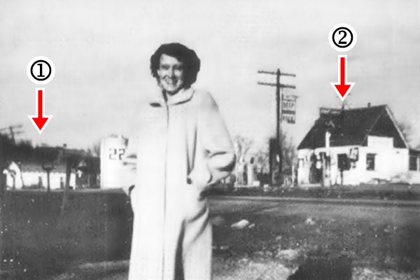
The image from "Show me Route 66" issue of Summer 1996 depicts Ms. Oral Potere in February 1955 with Route 66 behind her, and on the right side Terry's Deep Rock service station (2), and on the left Clementine's church (1). Below is the same spot nowadays.
Church and Terry's Service Station nowadays.
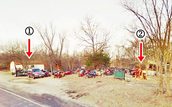
Oral was the granddaughter of Darius "Dan" Bartram, who lived across the street from Terry's station, and was the owner of the adjacent "Ozark Gift Shop" from 1933 to 1954, when the community was bypassed by the new alignment.
The Terry's bought it and ran it until the early 1970s when it closed for good. The shop sold wood furniture, local Ozark crafts and of course, baskets. The old building fell into disrepair and you can see some rubble and old timber among the trees (street view).
Terry's Deep Rock Gas Station
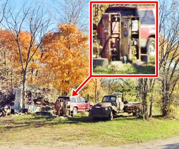
Also to your left, the building collapsed and gone but the concrete pump island with two vintage pumps still marks the spot, see (2) in the "Then and Now" images above.
Edgar and Peral Terry owned the gas station, that burned down in 1957 but was rebuilt. The years have taken their toll and the building finally collapsed; in this 2009 view, it was still there, but falling apart.
Gas pumps at Terry's Service Station.
Deep Rock was an Oklahoma based oil company that began operating in 1913 and was acquired by Kerr McGee Co. in 1955.
Fischer's Sinclair

1932 photo Fischer's Sinclair. Credits
Just ahead, to your left is the site of the old Fischer Sinclair.
The Sinclair station was owned by Roy Fischer, the gable roof woodframe building also had a grocery store and cottages.
The black and white photo was taken in 1932.
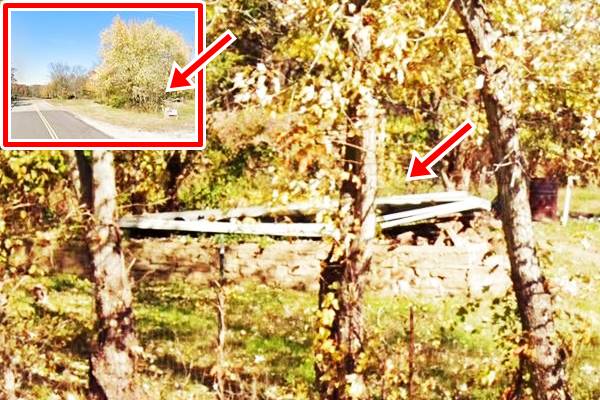
The old gas station has been torn down but you can still see its rock foundations in the fenced off lot next to the garage. See it pictured below. The inset shows it from afar.
Ahead I-44 cuts the original alignment (see the Map further up). Here was the home and store of the Childers, to your right.
The store "Artful Woodwork Made By Ozark Hillbillies", sold baskets. Henry and Sara Childers also had some cabins on their property.
Cross the freeway to see the only Route 66 landmark that survived the building of the four-lane U.S. 66 in the early 1950s and the modern I-44 roadbed later: Bennett’s Catfish Cafe.
Bennett's Catfish Café

Aerial photo Bennett Cafe from 1955. Click to enlarge. Credits
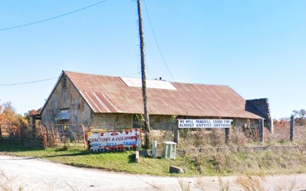
At 24899 Clementine South Outer Rd. just north of Exit 169 on the eastern side of I-44. It was also known as Surplus City. Built in 1948 in the typical Ozark "giraffe rock" style, it was a café with a long narrow building facing the highway.
The western wing of the propery burned in 1969.
It originally opened as Bennett's Doolittle Cafe in 1942 and was run by Paul and Gladys Bennett. The year after Paul's death in 1951, Route 66 bypassed their store so Gladys moved it to this new location where she operated it until 1966. At that time I-44 cut off the old U.S. 66 again. Gladys quit, and closed her cafe.
You can see the building in the black and white image (see the original zoomable 1955 aerial photo).
Bennett’s Catfish Café in Clementine, Missouri
This marks the end of your Clementine City Tour. Continue your Route 66 Road Trip and head west along the "Four Lane 1940s U.S. 66" to visit Hooker.

Some sponsored content
> > Book your Hotel in Lebanon

Credits
Banner image: Hackberry General Store, Hackberry, Arizona by Perla Eichenblat
Jack DeVere Rittenhouse, (1946). A Guide Book to Highway 66
Missouri: The WPA Guide to the "Show Me" State (1941)
Show me Route 66, Summer 1996 ed.
Architectural - Historic Survey of Route 66 in Missouri and Detailed Survey, Maura Johnson. 1993


