Your Route 66 Road Trip through Hooker
Index to this page

TheRoute-66.com is reader-supported. When you buy through links on our site, we may earn an affiliate commission at no additional cost to you.
About Hooker Missouri
Facts, Trivia and useful information
Elevation: 710 ft (2176 m). Population n⁄a (2010).
Time zone: Central (CST): UTC minus 6 hours. Summer (DST) CDT (UTC-5).
Hooker is a tiny unincorporated hamlet, almost a ghost town, located on Route 66 in northwestern Pulaski County, in Missouri's central Ozarks.
History of Hooker
For the general history of the area check the History of Waynesville.
This tiny village was located on the eastern side of the Big Piney River close to the Gasconade River. Originally a lumberjack settlement, it was on the road that linked St. Louis with Waynesville known as the "Wire Road" built during the 1860s to service the telegraph line from St. Louis to Fort Smith in Arkansas.
The name: Hooker
Despite the naughty connotation of the slang term "Hooker", the town was named for a man, John Hooker who owned the land here. The surname was applied to "the hooker", a maker of hooks or to someone who lived by a hook of land.
It had a Cemetery by 1900 and a church, which can still be seen. Later the old "Wire Road" became State Highway 14, and in 1926 it was incorporated into Route 66 which brought a steady flow of visitors to the area. Gas stations and stores selling local crafts sprung up along the road. However in 1941 construction began to make the meandering road safer, the new alignment, a four-lane divided highway (the first in the state and one of the first in America) bypassed the town when completed in 1943. Route 66 was definitively bypassed here by a new alignment of I- 55 in 1981 and the old road is now used by Route 66 fans or local traffic.
The western tip of Route 66 boasts the second freeway in America, and the first west of the Mississippi River, the Historic Arroyo Seco Parkway built in 1940.

Find your Hotel near Hooker Missouri
You can find a hotel or motel nearby in St. Robert; it has good accommodation options.
> > Book your hotel in Saint Robert
More hotels close to Hooker on Route 66
There are several hotels in the area close to this town. Alternatively you can also find your accommodation along Route 66 in the neighboring towns and cities in Missouri. We list them below (from east to west):
On Route 66's Main alignment in MO
Eastwards
Westwards
- Hotels in Kansas
- Baxter Springs KS
- Galena KS
- Riverton KS
- Hotels in Oklahoma
- Miami OK
>> Check out the RV campground in neighboring Waynesville
Weather in Hooker Missouri

Location of Hooker on U.S. Hwy. 66
Hooker has a summer average high (Jul) of 88°F (31.2°C), and an average low of 67°F (19.2°C). The winter (Jan) average high is 42°F (5.6°C) and the average low is below freezing at 20°F (-7°C).
Rainfall is around 44.5 in (1.131 mm) yearly and snowfall averages 9 in. (23 cm), falling from Dec. to March.
Tornado risk
Hooker is located inside the Missouri "Tornado Alley" and Pulaski County is hit by some 8 tornado strikes every year.
Tornado Risk: read more about Tornado Risk along Route66.
Map of Route 66 in Hooker MO
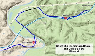
At I-44's Exit 169, Route 66 is cut by the freeway, and after this point it runs along the south side of the interstate from Clementine into Hooker. The original two-lane alignment is shown in this 1926-1943 US 66 Map. This alignment is shown in Blue in the map. There is a gap in the alignment (black line) where I-44 obliterated part of the old road. Then comes the western segment that goes through Devil’s Elbow shown in Blue in the image, and also in this map.
The 1943 to 1977 Route 66 alignment

USGS Map from 1942 showing Route 66 in Devil's Elbow.
See thumbnail of a USGS map from 1942. The red arrows mark the original 1926 alignment winding around hills, the blue arrows mark the new wider and straigher 4-lane highway.
When Fort Leonard Wood opened just before the World War II, construction teams and material were brought by truck along US 66. A railroad spur was being built but until it was finished, the highway carried all the heavy traffic. Route 66 was narrow and had many curves it wasn't safe and it was very congested. A completely new four-lane divided highway was built across Hooker.
This "freeway" became, together with the Pennsylvania Turnpike, the only two highways with four lanes in the U.S. at that time. The new highway opened in 1943 and consisted of a completely new and straight alignment with two lanes separated by a central curbed division.
This new alignment is shown in Pale Blue in the map, and also in this 1943-1977 Map with directions.
It remained in use even after I-44 replaced Route 66 in 1977. It was later bypassed in 1981 by what is now the current roadbed of I-44 from Morgan Heights to Clementine.
The Route 66 alignment in Hooker
Visit our pages, with old maps and plenty of information about US 66's alignments.
- Springfield to Joplin (next)
- Rolla to Springfield (in Hooker)
- Gray Summit to Rolla (previous)
Route 66 across Missouri
Historic U.S. highway 66, "Route 66" has been designated as an All-American Road and National Scenic Byway in the state of Missouri.
Route 66 Sights in Hooker
Landmarks and Places to See in the Vanished Town of Hooker
Historic context, the classic Route 66 in Hooker
The WPA wrote in the 1941 "Missouri, a guide to the "Show Me" state" about this tiny community.
HOOKER... a focal point for fishermen on the Big Piney, Gasconade and smaller streams. The highway passes through a mountainous section where second-growth oaks are dwarfed by the few primeval giants lumbering men have left WPA Guide to the "Show Me" state (1941)
Tourists used to arrive by train to neighboring Crocker or Jerome and lodge here to enjoy nature. Jack DeVere Rittenhouse published his "A Guide Book to Highway 66" in 1946 and he mentioned the village as follows.
You now enter a stretch of divided highway, built during World War II to facilitate traffic to Fort-Leonard Wood, which is nearby. The road is an engineering triumph and truly a joy to the traveler.... HOOKER (Pop. 120; alt 710'; gas; no other accommodations) Rittenhouse (1946)
Start your tour at I-44's Exit 169 on the western side of Clementine and head west along Old Route 66 (Now Highway Z).
The two lane road curves to the left away from I-44 and becomes a four-lane divided highway built in 1942.
The 1943 to 1977 Four-Lane Route 66 alignment
As it became clear that the U.S. would become involved in the war raging in Europe, the Army created a training camp in 1940 close to what is now St. Robert Missouri. It was named Fort Leonard Wood. The construction of the fort required a large workforce and building materials. Route 66 was used to move people and freight to the area but it was narrow and snaked around the Ozark hills in the area.
The highway became congested and Route 66 honored its nickname of "Bloody 66": between January and September 1941 there were 454 accidents on U.S. highway 66 that killed 54 people, including 19 U.S. soldiers.
While a railroad spur was being built from Newburg to Fort Leonard Wood, the War Department had a four-lane highway built through this dangerous area. Instead of winding around the hills coasting the Big Piney River, the new road would cut a straight line from Clementine to Grandview.
A New Concept in Highways

Route 66 in Hooker (Satellite view).
Click image to enlarge
The image (click on it for full sized view) shows a satellite view of Hooker and Devil's Elbow with the different alignments and the site of Hooker Hill Cut. Notice the hilly terrain and how the original alignment curved around Hooker Hill while the newer one cut across it (at Hooker Hill Cut).
The work was done by the Missouri State Highway Department with C. W, Brown as chief engineer, J. J. Corbett as construction engineer and P. H. Daniells as head of plans. Fred Weber, Jr. Construction won the bid.
It was straighter, and shorter (3.6 vs. 5.2 miles), shaving off 1.6 miles of snaking single lane highway between Grandview and Clementine. It was more level with maximum grades of 5.7 percent (moste were less than 5 percent). Curves were avoided as much as possible with a maximum 2 degree curvature and two wide 400-foot radius curves.
It has two sets of dual-lanes 22 feet wide, each pair of lanes was three feet wider than the original Route 66 roadbed. It had a median divider 6 to 54 feet wide. Curbs were build on both divider and shoulder with the intention of directing rainwater, but they proved to be unsafe for vehicles that veered off course.
Hooker Hill Cut
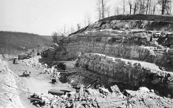
To keep a straighter course, the new highway had to cut across a high ridge of sandstone on Hooker Hill. This required moving 250,000 cubic yards of dirt, of which 200,000 cu. yds. were rock weighing 300,000 tons.
The Cut is 93 feet deep (some sources say 110 and 115 feet), blasted with dynamite and over 1,100 feet long.
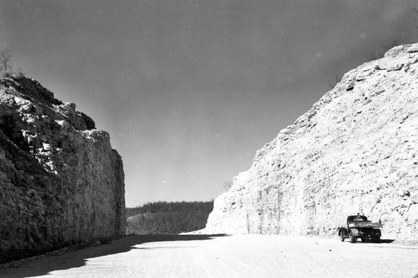
Work began in September 1941 and the segment wasn't completed until December 1945, including the new bridge across the Big Piney River that bypassed Devil's Elbow's narrow bridge which had a dogleg on its eastern side.
The cut across Hooker Hill is narrow and steep but it included a shoulder on each side of the highway and a terraced cut on the top of each wall to prevent falling rocks from hitting the traffic, they would fall on the terrace or shoulder.
The broken rock removed from the cut was used for fill in low lying places.
See this Map with location.
Old Postcard of Hooker Cut, on four-lane U.S. Highway 66 in Hooker, Missouri
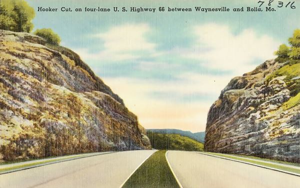
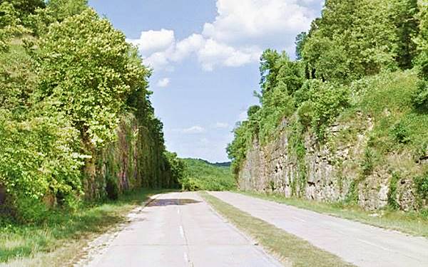
Hooker Cut nowadays in Hooker, Missouri
In 1974 it was decided that the eastern terminus of Route 66 would be moved from Chicago to Scotland MO (just east of Joplin). However, this move was delayed until I-55 in Illinois was completely brought up to Interstate standards. The Route 66 signs were removed in 1977 but the last segment of the old Route 66 to be bypassed was the section in Powellville and, here, in Hooker, in 1981 when a new alignment was built for the freeway (the current one). Route 66 was decertified as a U.S. highway in 1985.
See this map Map showing I-44 1981 realignment in Hooker.
It was in its time the largest rock cut in Missouri Highway history and was the deepest road cut in America for many years.
The "new" alignment opened after WWII ended, but remained in use for many decades. Over the next few years the whole of US 66 in this area was upgraded to a four lane highway with overpasses, and after 1958 when I-44 was designated in this part of Missouri, it coexisted with the new interstate I-44.
As you drive west, you will notice a few scattered homes along the highway, and along the original Route 66 (to your right, Trout Rd.)
Sterling Hillbilly Store
Ahead, to your left, where Trout Rd. meets Route 66 before curving off again to the right, is the site of the old "Sterling Hillbilly Store." Map with location.
As you can see in the "Then and Now" sequence below the gabled house is the same one whose roof can be seen in the postcard and the white water pump to in the postcard is still there, now painted red (see blue arrows).
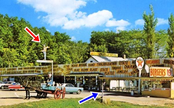
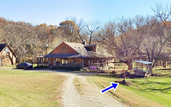

Hillbilly detail, from postcard above. US 66 Hooker
Squire and Anna Wells operated the "Wells Station" in Hooker on the old 1926 alignment of US 66 (Near the place where Trophy Ln. now reaches I-44). Their son Sterling also managed it. But, when the four lane alignment bypassed them, he relocated the business to the new four-lane highway.
He had a store with cabins and a camping spot He also sold 19¢ burgers and crafts in a Hillbilly-style cabin.
It had a neon light hillbilly that had moving arms to attract travelers (red arrow in both images).
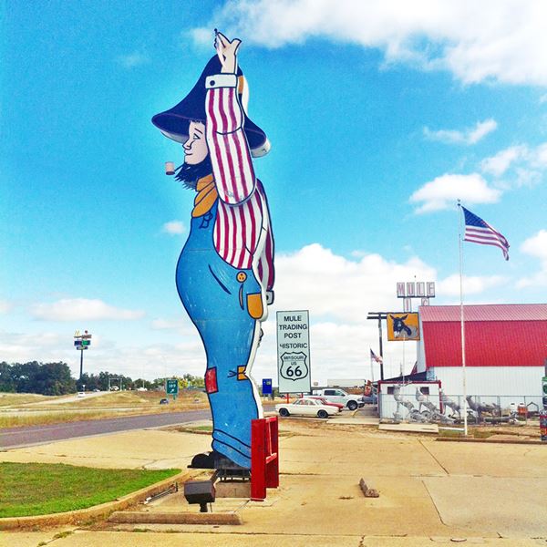
The old hillbilly sign is now further east, it was set up in front of the Mule Tobacco Barn on Route 66 in Rolla, MO.
When the road was once again bypassed -now by I-44 being relocated in 1981 further west, he moved his business to I-44 and MO-28.
The "Hillbilly" nowadays at The Mule Trading Post in Rolla
Sterling Wells post was the only business that survived the bypassing of Hooker. All the others have vanished.
Hooker: The Ghost Town
There is no longer a town at Hooker, the original settlement located on the north curve of Teardrop Rd., was badly hit when the first freeway section was built in 1943, cutoff from the traffic flow. And it died when I-44 was realigned in 1981, cutting Teardrop Rd. and making it a dead end.
Hooker Trivia
There was a basket and furniture workshop in Hooker, and travelers stopped to buy the white oak strip baskets, it was a domestic handicraft industy.
To reach the old townsite of Hooker, take Trophy Ln., opposite the former Hillbilly post. The old Route 66 runs on the north side of the 4-lane alignment, just ahead, to your right is the old Cemetery.
Hooker Cemetery and chapel

Hooker Cemetery sign, credits
Just 0.3 mi. west of the point where Trophy Road leaves US 66, is the chapel next to the old graveyard dating back to 1900 (Map with location).
After the cemetery, the old alignment curves to the north it is concealed by the trees it heads towards the Freeway, passing under it. The original alignment turned left here, heading west, but now it is cut off.
Here was Hooker School and Church, the two-room Hooker School, Wells original gas station and Gray's Blacksmith Shop. Nothing remains. Turn back to Route 66 and head west. Ahead is Hooker Hill Cut, that we mentioned further up.
Continue west along the four-lane Route 66 and, to your left, at the junction with the Teardrop Road you will meet the old alignment coming from the right (north), from Barton's also known as Valley View, and the Calvary Baptist Church.
Continue your Route 66 Road Trip along the old and new Route 66 alignments, and visit Devil's Elbow.

Some sponsored content
> > Book your Hotel in Lebanon

Credits
Banner image: Hackberry General Store, Hackberry, Arizona by Perla Eichenblat
Jack DeVere Rittenhouse, (1946). A Guide Book to Highway 66
Missouri: The WPA Guide to the "Show Me" State (1941)
Architectural - Historic Survey of Route 66 in Missouri and Detailed Survey, Maura Johnson. 1993


