Your Route 66 Road Trip through Powellville
Index to this page
- About Powellville
- Weather
- Hotels close to Powellville
- Map of US 66
- What to see and do in Powellville
About Powellville Missouri
Facts, Trivia and useful information
Elevation: 990 ft (302 m). Population n⁄a (2010).
Time zone: Central (CST): UTC minus 6 hours. Summer (DST) CDT (UTC-5).
Powellville is a ghost town on the 1926-1981 alignment of Route 66 in Phelps County, central Missouri.
History of Powellville
Check our page with the History of Rolla and Phelps County to learn about its early history.
The state legislature created the county in 1857 and named it after John S. Phelps (1814-1866) congressman and state governor (1876).
The "Wire Road" was built in the 1860s next to the telegraph line that linked St. Louis with Fort Smith in Arkansas and passed close to what would become Powellville. In 1867, the railroad built a line west of Rolla through Arlington and Jerome, just north of Powellville. In the 1930s the Powell Brothers established a complex that included a filling station, motel with cabins, store and restaurant. It was demolished when I-44 was built in 1967. Now it is a ghost town.
The name: Powellville
After the surname of the tourist complex owners. It is a Welsh surname derived from the old Welsh name "Hywel" or "Huwel" which means "eminent" and
became "Howel" in English.
The Celtic prefix "ap" was added to the name; it means "son of", so preceding "Howel" to designate the "son of Howel" the Welsh name was "ap Howel" and this was deformed into "Powell".
When cars became more popular in the 1910s, State Highway 14 was created and it crossed a new bridge over the Little Piney River in 1923. MO-14 was made part of U.S. 66 in 1926, paved by 1931 and this attracted the Powell Brothers, who set up their business here, between Arlington and Clementine. After WWII in the 1950s, Route 66 was upgraded into a four-lane freeway and later it was improved to Interstate standards, during this process in 1968, the Powelville tourist complex was demolished.

Where to Lodge in Powellville, Missouri
There is no accommodation in Powellville but you can find your hotel or motel in neighboring St. Robert; which has plenty of lodging options.
> > Book your hotel in Saint Robert
More hotels Close to Powellville along Route 66
There are several hotels in the area close to this town. Alternatively you can also find your accommodation along Route 66 in the neighboring towns and cities in Missouri. We list them below (from east to west):
On Route 66's Main alignment in MO
Eastwards
Westwards
- Hotels in Kansas
- Baxter Springs KS
- Galena KS
- Riverton KS
- Hotels in Oklahoma
- Miami OK
>> Check out the RV campground in neighboring Jerome
Weather in Powellville

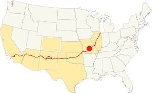
Location of Powellville on U.S. Hwy. 66
Powellville has well defined seasons, cool winters and warm summers; the average summer high (Jul) is 88°F (31.2°C), while the average low in 67°F (19.2°C). The winter (Jan) average high is 42°F (5.6°C) and the average low is 20°F (-7°C), below freezing.
Rainfall is around 44.5 in (1.131 mm) yearly and snowfall averages 9 in. (23 cm), falling from Dec. to Mar.
Tornado risk
Powellville is in the "Tornado Alley" and Phelps County, Missouri has around 8 tornado hits per year.
Tornado Risk: read more about Tornado Risk along Route66.
Map of Route 66 in Powellville
South of Jerome and Arlington, after crossing the Little Piney River, the old original 1926 Route 66 follows the North Outer Road. It was paved in 1932, and follows the alignment shown in this map from Jerome to Clementine.
In 1954 a new roadbed, with two lanes was built northwards from Clementine, through Powellville into Arlington, they were the eastbound lanes of the four-lane Route 66. The original US 66 became the new westbound lanes of this highway. Neginning in 1967 the US-66 ⁄ I-44 four-lane alignment was improved. The winding westbound lanes (which were the original 1926 Route 66) were inadequate so a new set of westbound lanes were built and they bypassed Powellville. And the original Route 66 roadbed became the North Outer Rd.
The Route 66 alignment in Powellville
Visit our pages with old maps and plenty of information about US 66's alignments.
- Springfield to Joplin (next)
- Rolla to Springfield (in Powellville)
- Gray Summit to Rolla (previous)
Route 66 Sights in Powellville
Landmarks and Places to See: a ghost town
Historic context, the classic Route 66 in Powellville
The WPA in its 1941 book, "Missouri, a guide to the "Show Me" state" does not mention Poewllville; instead, 2.4 miles west of Stony Dell it mentions the "graveled road... past tow large sinks, to ONYX PARK AND CAVE" that charged an admission of 35¢ and had a cavern almost one mile long.
The 1946 "A Guide Book to Highway 66" by Jack DeVere Rittenhouse places it 1 mile east of Clementine and 3 miles west of Stony Dell (Jerome), he says the following: "POWELLVILLE. A gas station, cafe and a few cabins.", one mile east of it was another "Cafe and a few cabins". He adds that this area in the Ozarks has many "small tourist camps" catering to week-end tourists from St. Louis and those traveling on cross-country trips. These accommodations were "more Spartan than... deluxe," because they also served fishermen.
Powelville Motel Tourist Complex

1942 USGS map showing Powelville (red arrow), the Onyx Cavern (blue arrow), Route 66 (red), and County line (hatched red).
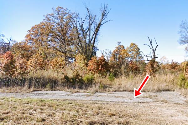
The only site that is more or less visible is the gravel entrance to the now gone Motel (pictured further down). Drive west, coming from Jerome along Old Route 66, and 2.1 mi west of Exit 72 is the site of the motel. See this map with directions.
It was a service station with a restaurant, general store and an auto-court (Motel) with ten cabins. The complex was owned by three brothers, Harry Powell. Harry married Fern Beckerdite in the early 1940s, but died shortly after his wedding. Fern continued operating the business until it was bypassed by the new Interstate and sold it in 1968 to the Missouri Dept. of Conservation which razed the site.
Harry and his brothers Herman and Jewel also owned a trucking company "Powell Brothers" that they established in 1927 and sold to TIME Inc. in the late 1950s.
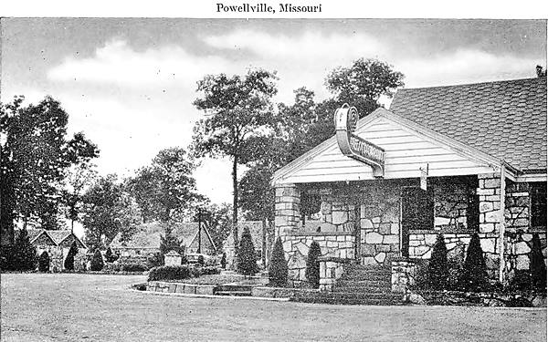
In the 1942 USGS map, marked with the red arrow, you can see the semi-circular distribution of the cabins around the central building. Their postcard pictured below announced: "POWELLVILLE - 24 Hr. Service - Modern Cabins- Restaurant". Its mailing address was in Arlington.
Motel and Cabins in a vintage postcard, Powellville, Missouri

Below is all that is left of the place, the access road next to Route 66.

There is one other landmark in Powellville, a natural attraction.
Onyx Caves
Listed in the National Register of Historic Places
14705 Private Drive 8541 (Map with directions).
Closed to visitors, it is on Private Property. Avoid trespassing
It can be reached via Co Rd 8540 and Pvt Rd 8541 which passes between two sinkholes: Slaughter Sink to the north and Conical Sink to the south.
The dolomite rock, which is Calcium magnesium carbonate or CaMg(CO3)2, is dissolved by acids contained in water that leaches through the soil. The acids form when water absorbs carbon dioxide or nitrogen oxides.
Ahead is the Onyx Cave also known as King Cave and Onyx Mountain Caverns was once mined for onyx, but its flaws and low quality bankrupted the venture.
It is 200 ft. above, and 1⁄4 mi. east of the Gasconade River (see the blue arrow in the map aboveby "Onyx Cave") and it has 30 foot long flowstone, stalactites and stalagmites, draperies and soda straws.
It was a tourist attraction from the early 1900s to the 1930s and then owned by Harry and Agnes Thiltgen since 1963 it was open to the public from 1990 to 2006 when Harry passed away. It went up for sale and finally, as it is home to endangered bats, it became a protected area, of scientific interest and closed to the general public.

Rock formations in Onyx Cave. Source

Boiling Springs in the Gasconade River. Source
Boiling Springs
"Boiling Springs" (or "Spring" according to other sources) is a spring that surges in the bed of the Gasconade river (see the blue arrow in the map above "Boiling Spr."). It is close to Onyx Cave, but is accessible from the western side of the river.
The spring has a flow of some 84 million gallons per day (336 million liters). And can be seen from the western side of the Gasconade River (via I-44, MO-28 and MO-PP to the Boiling Spring Campground - see this Map with directions).
This marks the end of tour through Powelville, you can continue your Route 66 Road Trip by heading west along Route 66 and visit Clementine.

Some sponsored content
> > Book your Hotel in Lebanon

Credits
Banner image: Hackberry General Store, Hackberry, Arizona by Perla Eichenblat
Jack DeVere Rittenhouse, (1946). A Guide Book to Highway 66
Missouri: The WPA Guide to the "Show Me" State (1941)
Show me Route 66, Summer 1996 ed.
Onyx Cave, National Register of Historic Places form NPS.
Architectural - Historic Survey of Route 66 in Missouri and Detailed Survey, Maura Johnson. 1993

