The town cut apart by Route 66
Index to this page
About Lela, Texas
Facts, Trivia and useful information
Elevation: 2,434 ft. (742 m). Population: est. 100 (2025).
Time zone: Central (CST): UTC minus 6 hours. Summer (DST) CDT (UTC-5).
Lela (pronounced "LEE luh") is located in Wheeler County, in the eastern region of the Texas Panhandle, 5 miles (8 km) west of Shamrock (the most important town in the area).
Lela, History
The Texan Panhandle has been inhabited for the last 10,000 years. The Spanish explored the region and made it part of their American colonies and to Mexican control after its independence in 1810 - 1821.
At that time the Comanche and Kiowa Indians peopled the plains and hunted buffalo there. The U.S. annexed Texas in 1845 and subdued the natives (1874 - 1875) allowing pioneers to settle there.
In 1902, the Chicago, Rock Island and Gulf Railway built a line westwards towards New Mexico and built a station in the place that was to become Lela.
The name "Lela"
Although the railway station and the community that sprung up next to it were named "Story", in 1903 the local postmaster Bedford Forrest Bowers, changed the town's name to Lela after Lela H. Smith, sister in law of his brother Isaac Bowers. The town adopted the new name and dropped Story.
The name derives from Leila which in Arabic means: night, dark beauty, and from Persian (dark-haired); it was most popular in the 1890s when 0.81% of the babies carried that name.
Lela grew slowly and most of its business gradually moved over to neighboring Shamrock. Its population was small yet it had a church and an elementary school. It had a period of growth with the oil boom in the mid 1920s, and later when Route 66 passed through the town. But Shamrock was to close and absorbed most of the travelers and growth.
In the mid 1960s, I-40 literally cut through one of the town's blocks, razing it. The post office closed in 1976
Today Lela is almost a ghost town without any open business, but the Historic school building still stands, in good shape, and so does its church. However, there are many homes no longer cared for or used by anyone.

Where to Stay near Lela
The closest town with a pick of places to stay is neighboring Shamrock, 5.3 mi east of Lela.
>> Book your Hotel in Shamrock
Lodging Near Lela along Route 66
The towns along Route 66 in Texas offer different lodging options. Check out some of the hotels and motels in the main towns below listed from east to west
In Texas Along Route 66
>> There are RV campgrounds close to Lela.
The Weather in Lela
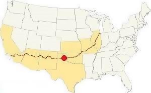
Location of Lela TX on Route 66
The Texas Panhandle region is dry and its average rainfall is only 24 in. (or 618 mm) yearly. During the summer the temperature averages maximum temperatures above 90°F (30°C) with minimum averages around 65°F (19°C). Winters have maximum averages of 50°F (10°C) and minimum averages that are below freezing point: 25°F (-4°C).
Snow is common during the period spanning September to May and you can expect snow to fall early in December, with around 16 inches yearly, although up to 40 inches have been recorded. That is: 43 to 102 cm.
Tornado risk
Wheeler County gets hit by about 10 tornados each year. Tornado Risk: learn more about Tornado Risk on US 66.
Map of Lela on Route 66 Texas
See this map with the alignment of US66 in Lela
Route 66 itinerary across Texas
We divided the course of the highway across Texas into two legs, from Texola in the east to Glenrio on the NM state line. The midpoint of Route 66 is located in Adrian TX:
Drive west from Shamrock along the South Frontage Rd. At I-40 Exit 157 take a right turn to visit what is left of Lela, on the north side of the freeway. Part of the town's block that faced US66 now lies under the freeway. See this map with US 66 alignment in Lela.
You can also check out our Route 66 Map in Texas, with the complete description of its different alignments and all the towns along them.
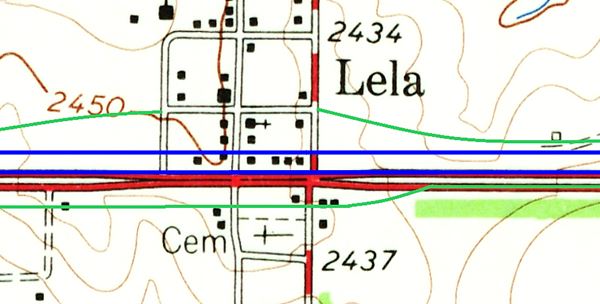
The map above, published by the USGS in 1963 shows how the 4-lane US 66 of those days passed through Lela (red lines). The original westbound lanes are now buried under the eastbound lanes of I-4O (lower blue line). The two city blocks that faced old Route 66 was razed and the westbound lanes of the freeway were built across them (upper blue line). Then the south frontage Rd. (bottom green line) was built and continued the old eastbound Route 66 past the Cemetery. On the north side, a new frontage Rd. was built and it went through what was left of Lela (upper green line).
Below is a view looking west along I-40 from Lela's overpass. The red arrows show where the frontage roads are (1) South and (2) North, the green overlay marks the original level of the terrain, where a city block was razed to make space for the cut through which I-40 now runs, following US66's alignment.
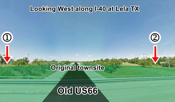
Route 66 Alignment near Lela
- Amarillo to Glenrio (next)
- Texola to Amarillo (Lela's)
- Clinton to Texola (previous)
Lela’s Route 66 Landmarks
Almost a Ghost Town
In 1946 Jack Rittenhouse drove along Route 66 gathering information for his book "A Guide Book to Highway 66", he mentioned Lela as follows.
A small settlement, consisting of five gas stations, a cafe and a post office. Rittenhouse (1946)

Lela cemetery, Source. Click for St. view
The small community has gradaull faded away since then. It is barely three blocks long and two deep. Highway 66 runs on the south side of the town, as I-40's South Service Road. And Farm to Market 3075 Rd. marks its eastern border.
Drive from Shamrock westwards along the South Frontage Road. At the overpass at Exit 157, ahead to your left, on the SW corner of 3075 Rd. is the cemetery.
Lela Cemetery
With a very austere seven-bar steel gate with the letters "L E L A" welded onto the upper bar.
Diamond Shamrock station
Next door is a renewed gas staton. Formerly a Diamond Shamrock, it opened in 1975 on the Frontage Road. A gable roof building, canopy to the west. Concrete apron.
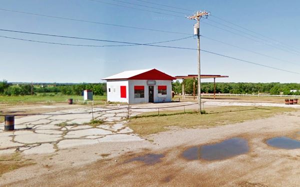
Hines Shell Truck Stop
Head back to the overpass. The area now occupied by I-40 was once the southern side of Lela, and Route 66 ran more or less on the eastbound lanes of I-40 and the median strip are now located, but at the level of the town (the freeway runs through a cut). On the north side of the intersate, to your left is Hines Shell Truck Stop, built in 1970.
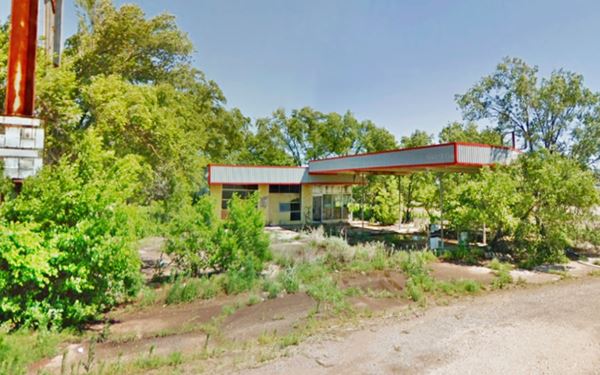
Lela Elementary School
Take a right turn at 2nd St. and after one block you will reach the Historic School Building on the north side of Maple St. (2nd St. at Maple St.)
Texas Historical Commission Marker
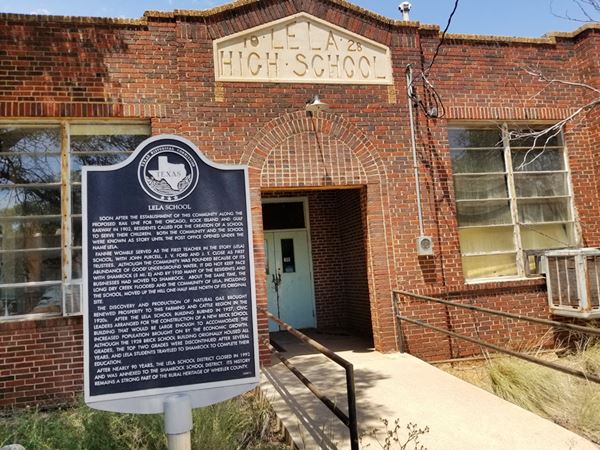
The school opened shortly after the station was established. In the mid 1920s the Long Dry Creek unexpectedly flooded the town and school, leading to its relocation half a mile uphill towards the north. The school burned down in 1927 and a brick building replaced it in 1928 (the year is inscribed in the white sandstone frieze above the entrance.
Students of the upper grades soon moved to Shamrock and as population diminished so did the students. the Lela School district closed in 1992 and was annexed to Shamrock's district.
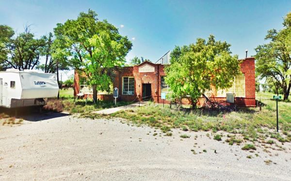
The marker on the left side of the entrance tells the story of the school and the community.
Rattle Snakes Sign (Lela Snake Pit)
Formerly at Exit 148 of I-40, on the north side of the freeway. Now in McLean. It is 8.7 miles west of Lela (map).

Original Rattlesnakes Sign. Carol Highsmith
This is actually a «non-landmark» because it is no longer there: the sign has been relocated to neighboring Mc Lean further west.
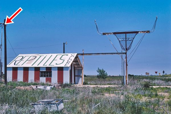
There was a sign in the past, that stood by the freeway's Exit that advertised the «Regal Reptile Ranch» with an enticing text: «Rattlesnakes - Exit Now».
Road shows with rattlesnakes were an attraction during the 1950s and 60s. This one belonged to E. Mike Allred, who had also operated other snake pits along Route 66 in Oklahoma as well as one Alanreed, Texas.
Allred's roadside snake pit was housed in a service station next to the exit. The very tall sign was blown over by strong winds in March 2007, one of the two posts is still standing (St. view).
The service station building is gone but you can still spot some remains of its foundations in the tall grass, below is a photo taken in 1982, the red arrow shows the slim steel pole behind a light post with the "rattlesnakes" sign.
Restoration and relocation to McLean
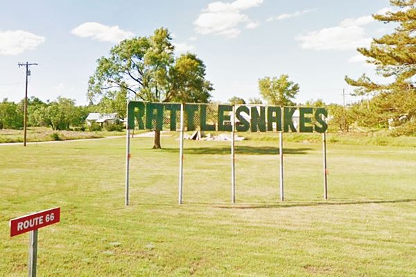
The upper part of the sign was rescued and relocated to neighboring McLean by Ruth and Delbert Trew, it still decries «Rattlesnakes» in dark green letters but on shorter "wind-proof" posts.
It is on a grassy stretch on the north side of 1st St. between Mc Carty and Donley Streets, McLean, TX.
Some of the snakes can be seen, floating in jars with formalin, at the Devil's Rope Museum in McLean.
This is the end of your Lela "city tour". Head west into McLean
Sponsored Content

>> Book your Hotel in Amarillo Texas

Source
Banner image: Hackberry General Store, Hackberry, Arizona by Perla Eichenblat
Jack DeVere Rittenhouse, (1946). A Guide Book to Highway 66.
H. Allen Anderson, "Lela, TX," Handbook of Texas Online. Uploaded on June 15, 2010. Published by the Texas State Historical Association

