Route 66 in Fontana CA
Index to this page
About Fontana California
Facts, Trivia and useful information
Elevation: 1,237 ft (377 m). Population 216,350 (20254).
Time zone: Pacific (MST): UTC minus 8 hours. Summer (DST) PDT (UTC-7).
Fontana is a city located on Route 66, in southwestern San Bernardino County in the south of California. It is the second city in the county and the 20th in the state, ranked by population.
The History of the city of Fontana, California
Check our San Bernardino webpage for the early history of this region.
The San Bernardino & Los Angeles Railway incorporated in 1886 and built a line between San Bernardino and Duarte the following year. At Duarte it linked with the Los Angeles and San Gabriel Valley Railroad that went through Pasadena and Arroyo Seco into downtown Los Angeles.
Twentyfive stations were established along the line, every 2,600 yards and many of the current towns grew up around them like Fontana, Rialto and Cucamonga. The Atchison Topeka & Santa Fe railroad bought out these competing railroads and completed its line from St. Louis to Los Angeles.
In 1887, the Semi-Tropic Land and Water company founded several townsites in the area: Rialto, Bloomington, and Fontana. But the colony never took off. Semi-Tropic went bankrupt shortly after.

Fontana Girl brand, 1920s. Source
In 1905, the Fontana Development Co. acquired its 15,587 acres of land and Azariel Blanchard Miller developed the area by founding a new town, named "Rosena". He expanded the company to Fontana Co. in 1912, and in 1913 renamed the town, after the company, as "Fontana." It prospered as a "fruit colony" with lemon and orange groves (like the "Orange Girl" brand pictured).
Fontana, the name
Fontana is an italian word, for "fountain." And also a Spanish word used only in poetry that means "spring."
The National Old Trails or N.O.T. highway was aligned through the area in the early 1910s, paved and later, in 1926 adopted as the alignment for Route 66. It was an open country with orange groves spotted with some buildings along the roadway. Nowadays this eastern part of Historic Route 66 in the Greater LA is still pretty open, with a few fields and some empty lots, but nearer Los Angeles the old classic fruit stands, motels, service stations and shops have been razed and replaced by newer buildings and shopping malls.
Fontana Steel Mill
Entrepreneur Henry J. Kaiser built a large steel mill in Fontana in 1941, during World War II, to supply the ship-building yards in Long Beach, this turned the rural farm town into an industrial one. Steel workers moved in and settled in Fontana. It was one of only two steel mills located west of the Mississippi River. Kaiser also built what is now the "Fontana Kaiser Permanent" medical facility - the largest managed care organization in the US.
In the 1980s the mill closed for good. Many movies scenes were shot there: the steel mill scene in "Terminator 2: Judgment Day" (1991) and the Outworld scenes in the film version of Mortal Kombat (1995).
Fontana Trivia
The Hells Angels Motorcycle Club was founded in Fontana, in 1948.
The town incorporated in 1952 and shortly after, the freeway system in LA would start to divert traffic away from Route 66. By 1964, Route 66 had been replaced by the freeway, though it remained a highway here until 1973; in 1966 Fontana joined the city of Duarte trying to have a large sign posted in San Bernardino to announce that Route 66 remained a through route into Los Angeles, they failed.

Accommodation in Fontana
You can find your room in Fontana.
> > Book your Hotel in Fontana
More Lodging near Fontana along Route 66
Below you will find a list some of the towns along Route 66 east and west of Fontana; click on any of the links to find your hotel in these towns.
>> Check out the RV campground near Fontana, in San Bernardino
The Weather in Fontana
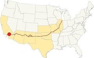
Location of Fontana on Route 66
Fontana has a Continental Mediterranean climate, that has hot and dry summers with cool and chilly winters.
The strong, hot and dry Santa Ana winds blow through Cajon Pass can be felt during autumn (fall). They dry the area increasing the risk of wildfires the foothill and canyon communities.
During winter, the average high in (Jan) is 69°F (20°C) and the average low is 46°F (7.2°C). For summer the average high is 95°F (35°C) and the average low is 63°F (16.8°C). Rainfall averages 14.8 in. per year (375 mm), with the period April to October being the driest one.
Snow can be seen on the San Gabriel Mountains, but never along Route 66.
Tornado risk
As Fontana is located very far from the Rocky Muontains (western limit for tornadoes), there is no risk of tornadoes in this area.
Tornado Risk: read more about Tornado Risk along Route66.
Map of Route 66 in Fontana
>> Custom map of Route 66 through Fontana.
From the N.O.T. Highway to U.S. 66
The use of the automobile had grown considerably during the early 1900s and there was a need for better roads, the The National Old Trails (N.O.T.) Association was organized to promote a highway between Los Angeles and New York; which was aligned close to the tracks of the AT & Santa Fe railroad through California and Arizona, passing through Fontana's townsite. The Foothill Boulevard was improved in 1913 and the Automobile Club of Southern California's map of 1912 shows the N.O.T. highway running on the north side of the Santa Fe Railroad all the way to Cucamonga. In those days Fontana did not appear in the map (it was named the following year).
In 1926, the N.O.T. alignment became part of the newly created U.S. Highway 66. And it was gradually improved and widened after that date. The map below was published one year later (1927) and you can follow Route 66 from Victorville through Cajon, San Bernardino and west into Los Angeles; Fontana appears in the map.

1927 Road map, SW CA
Click on image to enlarge.
Credits

1956 Shell Roadmap, SW CA
Click on image to enlarge.
Credits

Detail 1930 roadmap
Click on image to enlarge.
Full map
The thumbnail map shows the alignment of Route 66 from Victorville to Los Angeles, you can see Fontana.
The map above shows the same area in 1956; a freeway now links Victorville with Cajon and San Bernardino with Los Angeles. Fontana appears west of San Bernardino.
In 1964 the western terminus of Route 66 was formally moved from Santa Monica to Needles CA; however, only the highways up to Pasadena were decertified, the remaining ones remained signed as Route 66 until I-40 was completed between Barstow and Needles in the early 1970s, bypassing Fontana for good.
Route 66 Alignment near Fontana
With maps and full information on the Mother Road.
- Pasadena to Santa Monica (Next)
- Barstow to Pasadena (Fontana's)
- Topock to Barstow (Previous)

Fontana's Landmarks and Attractions
Classic US 66 sights!
Historic Context of Route 66
The "Guide to the Golden State" written in 1939 by WPA, said the following about this section of Route 66 during the pre-World War II days:
West of San Bernardino US 66 runs along the base of the Sierra Madre Mountains through the heart of a picture post card landscape orange groves overlooked by snowcapped peaks. The tile-roofed stucco towns among the orchards along the way are starting points for roads and trails into the forested mountains.
From [Rialto] US 66 runs through billowing foothills past miles of citrus groves and vineyards.
The boulevard skirts the northern edge of FONTANA, 5.2 m. (1,242 alt., 6,120 pop.), in a section of small citrus, grape, walnut, poultry, and rabbit farms. West of Fontana vineyards cover the foothills, dotted with wineries. WPA (1939)
The 1940s Caltrans road map shows Route 66 running straight west along Foothill Blvd., through Rialto and Fontana, then south of Etiwanda and Alta Loma and into Cucamonga. It was here that the Route 66 traveller encountered the eastern part of the Los Angeles suburbs, leaving the vast deserts behind.
Jack DeVere Rittenhouse drove along Route 66 in 1946, gathering information for his book "A Guide Book to Highway 66", he described this area, with it small towns as follows: " Many of them are so close together as to be practically indistinguishable from each other... at 320 mi. you pass through one edge of FONTANA, where Henry Kaiser built the first steel blast furnace west of the Rockies during World War II. Now you pass through vineyard country and orange groves."
The 1954 guide "U.S. 99, U.S. 101, U.S. 395 : with important connecting routes and national parks" published by the Automobile Club of Southern California, 1 stated:
Fontana, Calif. Alt. 1,242 Pop. 22,500
Fontana, 7 miles west of San Bernardino, on U.S. 66, and in an area producing diversified crops, including citrus fruits, grapes and walnuts, is also an important steel manufacturing center. Situated close to the Sn Gabriel and San Bernardino Mountains, Fontana has an attractive setting and is surrounded by small but thriving communities... ACSC (1954)
Fontana Sights and Stops on your Route 66 Road Trip
Driving west from Rialto along Foothill Blvd (Historic Route 66), you enter Fontana when you cross N Maple Ave., but this wasn't always so. The numbering system along Foothill in Rialto and Fontana changed in the 1950s, so the addresses marked on vintage postcards differ from the current ones.
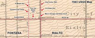
The 1943 USGS map -click on it to enlarge it- shows that the city limits between Rialto and Fontana was located at N Linden Ave. and not one block west, at N Maple Ave, as it is nowadays. You can see Mac’s Garage and Auto Court that we described in our Rialto page as being in Fontana in those days! Now it is in Rialto.

Fon-Tan Motel (gone)
The 1954 ACSC guidea and the 1963 local telephone directory mention this hotel as being located at 18388 E. Foothill with 6 rooms. The current numbering starts at 18200 on N. Maple, so this motel was located on the previous block (now part of Rialto) close on the even side of the highway (north), and though it is no longer standing, you can see it in the aerial photo taken in 1959, an L-shaped layout with gable roof. It was torn down around 2003. Current numbering is 1610 W Foothill, Rialto. All that remains is the paved drive along the former central courtyard as you can see in this street view.
El Adobe Motel
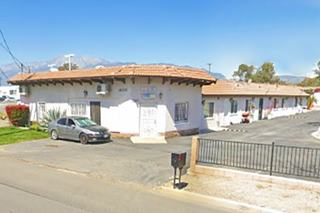
Cross N Maple Ave. and the "old" city limits of Fontana, ahead to your right, at 18202 Foothill Blvd. is the former El Adobe Motel. In the 1940s it was located at 744 E. Foothill Blvd. before the number scheme was changed. It dates back to the 1940s and it appears in a 1948 aerial photograph of this area, surrounded by orange groves. Below is a "Now and Then" sequence; notice how the chamfered corner office and the Spanish tiles on the roof have survived.
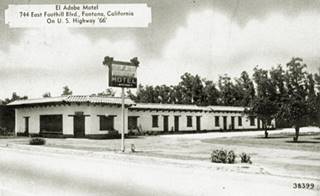
1940s postcard of the Adobe Motel. Fontana. Click to enlarge. Source
The Gas station on the SW corner with N Locust Ave (18083 Foothill Blvd) has been there since the 1950s, the same can be said about the one on the NE corner with N Laurel, now a tire shop at 17890 Foothill Blvd (St. view ). Both appear in the 1959 aerial photograph of this area.
Paradise Motel site
Adjacent to the tire shop, there was the Paradise motel that can be seen in the 1948 aerial photo (17858 Foothill), but it was torn down in the 2000s. Only the concrete foundations and drive have survived (St. view). Gerald and Dorothy Klein of Akron, Ohio moved here in the 1940s where they owned and operated the motel.
Rose Motel

1963 Telephone directory entry for the Rose Motel. Source
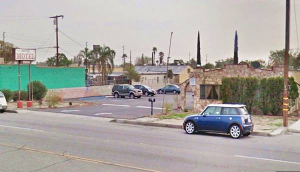
Opposite, on the same block, to your left, at 17829 E Foothill Blvd is the Rose Motel, that appears in the 1948 aerial pictures. It has rough stone walls with curved parapets and a neon sign that has been there since the 1980s.
The Rose Motel nowadays
Al Capone's hideout
Weird Stops along Route 66
Then take short side trip (3 miles round trip) to visit Al Capone's hideout home; see this map with directions.
The infamous mobster also known as "Scarface" Capone is said to have had a second residence in Fontana; it was intended to be his winter home in warm California. The property is located at 8775 Tamarind Ave. Whether it was his or not, has been debated, it is probably an urban myth.
Alphonse Gabriel "Al" Capone
American Gangster (1899 - 1947) was the boss of Chicago's organized crime during the Prohibition (1920s), he was jailed for tax evasion in 1931 at the age of 33. He was sick with syphilis and got worse in prison and was paroled in 1939, he died in 1947, aged 48.
The building has renovated and is now a private residence. The original chimney with a wrought-iron letter "C" on it (the gangster's initial) cans till be seen.
Former house of Al Capone nowadays, notice the "C" on the chimney (red arrow)
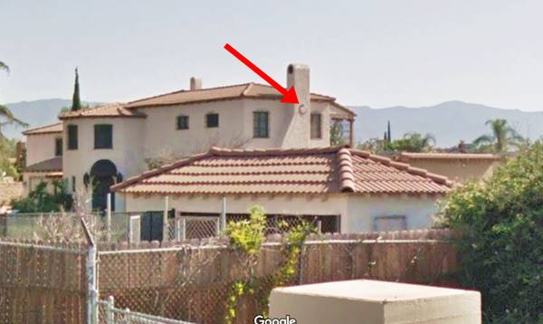
Return to Foothill Blvd. and Alder Ave. turn left and head west. Ahead is a classic motel.
Moana Motel
To your right at 17610 Foothill, this motel can be seen in the 1948 aerial photograph; it has two blocks of units on each side of a courtyard with roofed garages between some of the units in each block and a hip roofed office in the rear. The neon sign is original, a classic!

Original Dennys
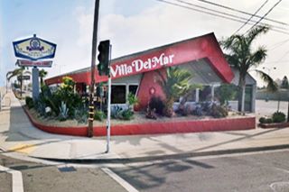
Ahead, to your left, on the SE corner of Foothill with Tamarind Ave. is a former Denny's Diner. It has the classic "Boomerang Roof", a design from the early 1960s by the Californian architectural firm Armet & Davis. They worked and defined the 1950s Space Age Googie architecture style in the Southwest. Now it is a Mexican Seafood restaurant (Villa del Mar). It has maintained the original hexagonal sign, typical of Denny's.
Orange Blossom Grocery (gone)
To your right, at the junction with Tamarind, on the NE corner was a classic grocery and gas station and cabins photographed by John Margolies in 1977. The site is now occupied by George's Burgers. Below is Margolies' photograph.


Muzzy's motel, ad. Fontana. Source
Westwards nothing remains from the golden days of Route 66; for instance, at 17184 Foothill was Muzzy's Motel in the 1940s and 50s, that later became the Circle Motel. There was a motel there in the 1938 aerial photograph. It had ten separate units around a central courtyard. See its advertisement in 1947, when housing was scarce in California. It was torn down in the mid 1980s.

Foothill Motors of Fontana. Source. Click image to enlarge
Foothill Motors
To your right at 17050 Foothill was the Foothill Motors of Fontana Inc., a Dodge-Chrysler dealership in the early 1960s. The glass salesroom has a four-wing butterfly roof. The place is still operating as a car sales lot. See its current St. view .
Downtown Fontana
At the next corner is the main junction in town, where Sierra Avenue crosses Foothill Blvd. Here there were several gas stations and a car dealership, all of them gone, bland, modern sites stand on the junction. History has been lost. Below is a view, looking to the NE at the intersection. On the NE corner (upper right) is a gas station with a triangular flat canopy typical of Union 76 at that time it was owned by Mr. Wayne Sr. Across Sierra Ave. on th NW corner is a Texaco station followed by Bader's Chevrolet. Across Foothill, on the SW corner is an Atlantic Richfield station with two separate radial canopies. Compare it with the same view nowadays and this is an 1959 aerial photo.

Bader Chevrolet (gone)
An Ihop stands now where Bill Bader's Chevrolet dealership stood back in the 1950s and 60s. Their slogan was "A Bader Buy is a Better Buy." In 1959 they had moved one block west, to Juniper and Foothill.


Fontana "arrow" c.1950s. Source
Below is a view looking NW from Sierra Ave. across Foothill Blvd. in the 1950s.
This is the same view nowadays.
The Richfield Station was owned by Heine. On the north side of Route 66 you can see the Chevrolet dealership and the Texaco station; beyond are the San Gabriel Mountains
On the Richfield's corner there was a sign stating "FONTANA" with an arrow pointing south (pictured), it can also be seen on the corner in the imgage below.

Downtown Fontana
Turning south (left) along Sierra Ave. takes you into the downtown commercial district of Fontana, centered along the railway depot. There was a classic Lodge here and an Art Deco Movie theater.
Fontana Inn (gone)
Fontana Inn opened in 1924 in Fontana, it was a classy lodge and had a pool, tennis courts, bungalows and was frequented by Los Angeles' upper class. In the 1930s it closed. The San Diego Archidiocese purchased the property for their Newman High School. Eventually it closed and was torn down in the 1960s. It was located at 8278 Sierra Ave. Below is a 1940s view of the main buildin. See this 1959 aerial photo.

Fontana Theater
Art Deco Classic
Ahead, at 8463 Sierra Ave. is an Art Deco building: The old theatre in downtown Fontana. Designed by the Boller Brothers in 1937 it could seat over 750 viewers. It closed in the 1950s and later became a skating rink. It has been restored to its former grandeur. Read more at its official website.

Turn around and return to Route 66, turn left and head west.
Dragon Motel (former Illini Motel)

Illini Motel 1950s matchcover
To your right at 16564 E Foothill Blvd; originally named "Illini Motel," it was owned and ran for 21 years by Luord C. Pfulb (1901-1988) who was born in Illinois and moved to California in 1950 where he opened the Illini, appropriately named after the Native Americans which gave their name to his home state was named. It has separate cottage-like units with gable roofs.

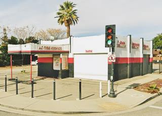
On the next corner (NE with Cypress Ave) at 16494 Foothill is a garage that was a filling station in the past and appears on this corner in the 1938 aerial photo of it. Notice the box shaped canopy by the small office and the two service bays facing each street.
Harold's Club (gone)
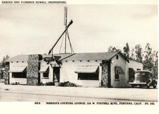
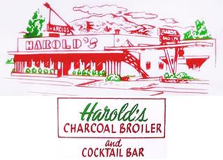
Ahead at 328 W Foothill (old address), current 16436 Foothill was Harold's Cocktail Lounge owned by Harold and Florence Powell. The 1940s postcard below shows the original building. A "New Dining Room [with a] New Charcoal Broiler" opened in 1947; the restaurant waas open from 6 to 10 PM daily and the cocktail Lounge from 4 PM to midnight. It was a restaurant, banquet hall and a Saturday night dancing spot.
Next door was the Fontana Texaco at 16414 Foothill; there is still a gas station here.
Fontana Motor Lodge
Adjacent to the gas station, to the west of it, at 16390 Foothill was the former Fontana Travelodge. It had a heated swimming pool, "Telephones, Television... 59 Beautiful Units." Still operating as a motel under the Fontana Motor Lodge name.
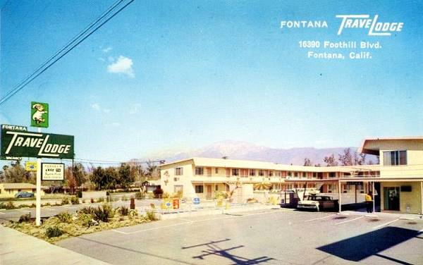
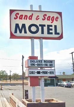
Sand and Sage Motel
To your right, beside the former Travelodge at 16364 E Foothill Blvd. It was built in 1955 in a refreshing Western ranch stlye with 12 with gable roofed units with garages between them, set out around a long deep courtyard. The main building features an wide and tall vertical red-brick wall facing the highway with the mothel's name painted on it, and lit up with neon lights at night.
Peter Orville Adair (1898-1982) was born in Conway Springs, Kasas and came to San Bernardino in 1926 where he owned a service station on Route 66. Later he was the owner of the motel, which he ran for 25-years. A heated swimming pool was added in the back of the property and the garages closed in.
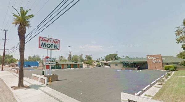
Three blocks west at 15808 Foothill, on the NE corner with Almeria Ave. is Padilla's Tire repair shop, but in the 1950s this was Angelo Palermo's Italian American Market; "the store with the most complete line of Italian Products." See its ad from Sept. 1954 below.

Angelo Palermo's market, 1954 ad. Source

Fontana Inn motel nowadays.
Inverso Motel
On the next block, to your right, at 15706 Foothill is the Fontana Inn; you can book your room here because it is still open and catering to travelers under the name Fontana Inn. In the 1950s it was the Inverso Motel, by the 1970s it had become the Arrow Motel, it appears in a 1948 aerial photo of the spot. It has separate gable roof buildings with 3 units each, on each side of a courtyard with the office in the back. Route 66 Mural on one of the units. Pictured above; see St. view.
Former Gas Station
Next to the motel is a former gas station that has stood there at least since 1938, as it appears in an aerial photograph taken that year. The flat canopy with curved tips still stands over the empty pumps island at 15690 Foothill. During the late 1950s and the 1960s, it was a realtor's office and now sells and repairs lawnmowers (St. view).
Pacific Electric
The highway passes under the "Pacific Electric" railroad tracks using an underpass built in 1931 to replace a grade crossing.
A bicycle trail now runs along the tracks of the former Pacific Electric Railway Company. It was known as the "Red Cars" and was a system of electric streetcars and buses that linked Los Angeles with its suburbs. Along Route 66 it reached San Bernardino. It was the largest electric railway system in the world in the 1920s. As cars became popular, it lost customers. It declined gradually, closing lines and ceased operating in 1964.
Arky's Barbecue (gone)
After the underpass, on the south side (left) of the highway was Mr. Arky's Barbecue, owned and operated by Hazel and Milton Blair aka Arky, from 1947 to 1958 famous for its barbecued meats; among its regular customers were Bing Crosby, Jack Benny, and Lucille Ball and Desi Arnaz. Later it became an adult bookstore. It had an animated neon sign with a pig that walked and twirled a baton. They served pies and ice cream for dessert and breakfast was donuts and coffee. Their postcard stated "Doggone your buttons. I'm glad you got this card. Now you know where you've been, but I don't know where you're going." 2

Bono's Restaurant and Deli
Listed in the National Register of Historic Places
Just ahead, on the left side of the highway, at the intersection with Sultana Ave. (15395 Foothill Blvd), to your left is a one-story building built in 1936 and expanded in 1943. It housed an Italian restaurant and Deli, which originally sold orange juice, olives, wine, and Italian foods (pizza, pasta) and fruits.
James Bono, who was born in Sicily, Italy, in 1898, moved to America with his family. He arrived in Fontana in 1926 and created Bono's Market which he ran with his wife Frances for 43 years.
Bono's "Hobby Nobby"

The north wall had a verandah opened towards Route 66 converting the building into an open outdoor market. In 1943 the font was glazed-in and the building was expanded to become a restaurant. Below is a view of it in the late 1990s. Notice how close it is to the highway and the lack of curbs.

The restaurant closed in 1994 and Joseph "Joe" Bono passed away in 2020. It had reopened in 2018 asa an Italian restaurant and used the Bono name but it didn't survive the Covid lockdown, closing in 2021. It has been purchased again and will be a Mexican Restaurant. The picture shows its current appearance.
Giant Orange (moved)
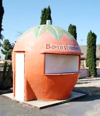
The Giant Orange fruit stand at Bono's
There was a large fruit juice stand on the western side of Bono's property, shaped like a gigantic orange. But it wasn't always located here. It didn't even belong to Bono.
It was built by Bob DeVries in 1936. His father Loomis P. DeVries opened the first orange juice stand in Fontana, on Foothill and Locust. His son later built the Giant Orange (6.5 ft. - 2 m. tall) with a wood framework covered with stucco. His fruit stand was located three miles to the east of
Bono's. Its bright orange color caught potential customers' eyes from afar. His son, Bob Jr. recalled that there was always four or five cars parked by it buying produce. They sold oranges at 50 cents a box, and orange juice "all you can drink for a dime." Carl Hoppy, Bob Jr.'s uncle ran it in the 1950s.
Later it was moved to the local Walmart on Route 66. In 1985 the DeVries family donated it to the Fontana Historic Society. Joe Bono, as president of the Society arranged for it to be loaned to his restaurant and he painted his name on it. The orange stood on Bono's land for 35 years. It suffered from weathering and time, slowly deteriorating. After the death of Bono and the sale of his restauant, the Fontana Historical Society stored the orange and is restoring it. It should be placed on display in downtown Fontana. 3, 4
Certo's Texaco

1963 Telephone book entry for Certo's Service Station
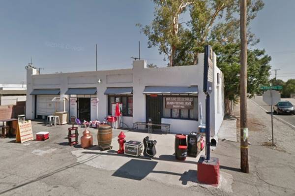
On the next corner, to your left, SE of Beech Ave and Foothill Blvd (15305 Foothill). is a classic former Texaco gas station, now Mancave Collectibles. It has kept the original two service bays and corner office of the old gas station. The canopy has gone and also the Spanish tiles along the pent roof; below is a "Then and Now" view of it.

The same old Texaco station nowadays
Westward Ho Motel (gone)
Across the highway, almost on the NE corner of Foothill with Beech, at what in those days was 880 W Foothill and now is 15320 Foothill Blvd, stood the Wetward-Ho Motel. Its postcard below, posted in 1957 tells us it had a Home-Like Atmosphere - 2 Acres of Park," it can be seen in the 1938 aerial photo of the area.
Now all that remains is the driveway around the oval shaped central garden in the courtyard and some palm trees (St view).

Now come three motels very close to one another.
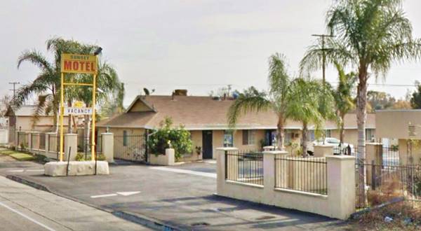
Sunset Motel
To your left, at 15243 Foothill Blvd is the Sunset Motel; it appears in the 1948 aerial photograph of this spot. In 1959 it was owned by J.C. Douglas and had 11 units, 9 with kitchen. In 1962 it was auctioned (with 14 rooms and a beer parlor in a separate property). Still open; pictured below.
40 Winks Motel
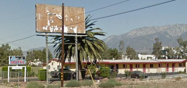
Just ahead, across the highway, to your right at 15210 E Foothill Blvd. "forty winks" means a short nap, a good name for a motel. It first appears in the 1959 aerial picture of this area. Pictured above
La Villa Motel
Opposite the Forty Winks, to your left, at 15211 E Foothill Blvd. It has individual cabins laid out in a "U" shape around the drive.
Cheryo Motel
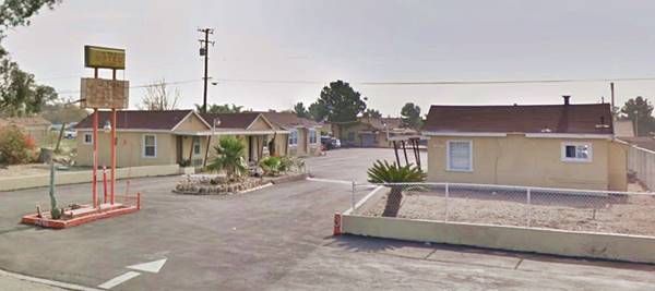
The last motel in Fontana is also to your left at 15161 E Foothill Blvd. The ten units are lined up on both sides of the plot, and are contiguous.
The newspapers from 1954 inform that it was owned by Mr. Ernest Goldi and his wife. They lived on the property with their family. In 1967 it was up for sale. It is still open (St. view ).
Redwing Motel
On the right side of the highway, at 14888 E Foothill Blvd. Fontana. It appeared in the 1954 issue of the Automobile Club of Southern California's guide to highways U.S. 99, 101 and 395, as being on (old numbering system) 1100 W. Foothill Blvd , with 11 Units. It has gable roofed units and a central office.

On the next corner, at 14688 Foothill (NW corner with Redwood Ave) is a former gas station, with its hip roof caonpy and vacant pump island. Now it is a garage with two service bays. Pictured below.

Road House, Fontana. Credits
Further west at 14564 Foothill, where the express carwash is located, was the now gone "Road House, Route 66, Fontana, California" photographed by John Margolies in 1977, pictured. See it before it was razed in this 2007 St. view .
Somewhere around here, the 1948-51 Ontario phone directory lists a "Motel Casa Redondo Fine New Units - Best Beds - Low Rates 1859 W Foothill Bl Fontana," but we have not been able to find any other reference that would allow us to locate it, though we believe it is the complex that appears in this St. view as it appears in the 1953 USGS map and aerial photos after 1948.
Continue your Road Trip
This leg of your journey ends here; continue your Route 66 Road Trip by heading west towards the next town along the highway: Rancho Cucamonga.
Outdoors, and Parks
Mary Vagle Nature Center
1501 Cypress Ave., Fontana (See map with location, 4 mi. south of Route 66). You can trek a 3 mi. (5 km) self-guided trail, visit the petroglyphs or inscriptions engraved in the rocks by ancient Native Americans at Fontana Pit and Groove Petroglyph Site. Enjoy the wildlife: rabbits, coyotes, foxes and rattlesnakes. Learn more at their Website (nature.fontana.org)

Sponsored Content
>> Book your Hotel in San Bernardino

Credits
Banner image: Hackberry General Store, Hackberry, Arizona by Perla Eichenblat
A Guide to the Golden State, by the Federal Writers' Project of the Works Progress Administration, Hastings House, New York, 1939.
Jack DeVere Rittenhouse, (1946). A Guide Book to Highway 66.


