Route 66 in San Jon New Mexico
Index to this page
About San Jon, New Mexico
Facts, Trivia and useful information
Elevation: 4,032 ft (1,229 m). Population: 158 (2025).
Time zone: Mountain (MST): UTC minus 7 hours. Summer (DST) MDT (UTC-6).
San Jon is the first real town in New Mexico along Route 66 coming from Texas. It is located in Quay county, on the eastern part of the state.
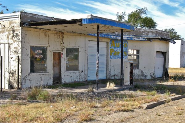
Old 1950s service station in San Jon
This part of New Mexico is very close to the Clovis site where very old stone tools (over 13,000 years old) have been found, an indication of its very long history.
The area was later explored by the Spanish, who introduced the horse (1500s), the local Querecho Apaches adopted it. By the mid-1800s, Kiowa and Kiowa Apache together with the Comanche dominated the region and fought with the U.S. Army and white settlers until subdued in the mid 1870s.
Soon cattle ranches were established in the region and the railway pushed westwards, reaching San Jon in 1904. The town had been established two years earlier.
It was named by its first postmaster, W. D. Bennet in 1906. Some stores took care of the local ranching community's needs, and got a big boost when Route 66 was aligned through the town in 1926.
The Name: San Jon
It is a rather odd name as it uses a Spanish language word "San" (Saint) followed by Jon (Jon is a shortened form of the name Jonathan and also John in some countries). But in Spanish there is no name like "Jon", there is only "Juan" (John)
The fact that the San Jon Creek which flows northeast from San Jon into Texas near Glenrio, figures as "San Juan" in the General Land Office Map of 1936, hints at a deformation of the Spanish name "San Juan" (Saint John).
Another version says that it is a corruption of the word "Zanjón", Spanish for ditch or gully. But it seems improbable.
Service stations, motels and diners were quickly established to cater to the tourists traveling along Route 66.
When I-40 was built, bypassing San Jon in 1981, business declined along Route 66 as it relocated to the Interstate interchange to the north.
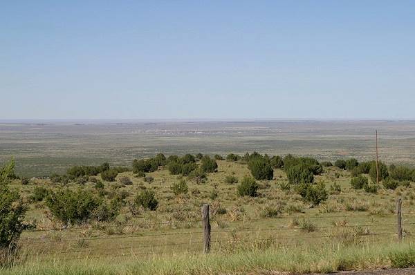
View of San Jon, looking north from the caprock escarpment of the Llano Estacado

Where to Stay
Find your hotel near San Jon. There are several hotels in nearby towns along Route 66
> > Book your Hotels in nearby Tucumcari or Santa Rosa
Lodging Near San Jon along Route 66
Below you will find a list of some of the towns along Route 66 in New Mexico. Click on any of the links to find your hotel, motel or accommodation in these towns (listed from east to west):
On Route 66's Main alignment
The Santa Fe Route 66 segment
Eastwards
Westwards
>> There are RV campgrounds close to San Jon.
Weather in San Jon
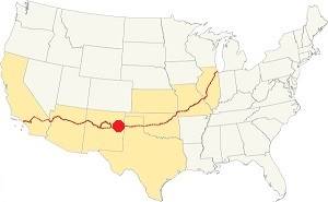
Location of San Jon on Route 66
This region is a relatively dry region. Summers are hot but lower temperature during the night makes them bearable.
The mean annual temperature is 59°F (15°C). Average high for summer (Jul) is 93°F (34°C), and for winter (Jan) 53°F (11.9°C). The average low in summer is 66°F (18.8°C) and in winter it is below freezing at 25°F (-3.8°C).
Rainfall is scarce, with most falling during summer (8 inches from June to Aug.), in total, on average, 18.2 inches (461 mm) fall annualy.
Snow: Snow falls in this region at any time between September and May (the first snowfall takes place usually, on the first week of December). The higher altitude provokes more snowfall than in locations further east: Snowfall averages around 21 inches (53 cm), with most falling during Dec. and Jan. (6 and 5 inches - 12.7 and 15 cm). But some snow storms may take place with over 40 inches of snow (1 m).
Tornado risk
San Jon has a very low tornado risk, with only three (3) Tornado watches every year.
Tornado Risk: read more about Tornado Risk along Route66.
Map of Route 66 in San Jon
See this Map of Route 66 through San Jon (1926-1952 alignment) (dirt road east of San Jon).
You can also visit our Route 66 Map of New Mexico. It has all of the alignments of US66 across the state over the course of the years, and the towns along it.
Route 66 Map Glenrio to Tucumcari in 1956
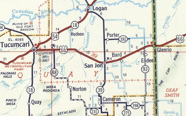
Glenrio to Tucumcari Historic Route 66
Route 66, Montoya, NM.
Listed in the National Register of Historic Places.
This segment of Route 66 is a historic landmark listed in the National Register of Historic Places and runs from Glenrio to Tucumcari.
We have a webpage that describes this historic alignment with maps and plenty details; vist our Glenrio to Tucumcari Historic Route 66 webpage for more information.
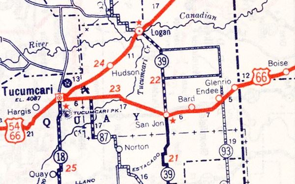
Route 66 Map close to San Jon in 1939
San Jon's Route 66 Attractions
In 1946, Jack DeVere Rittenhouse published his "A Guide Book to Highway 66". In it he described San Jon as follows: "Pop. 250... gas; garages: San Jon garage and San Jon Implement Co.; two courts; cafes; small hotel; stores." He added that "San Jon is still a center where cowboys can come for Saturday night relaxation."
At that time there were many gas stations and garages on Route 66 in San Jon, now only a few are still standing: Frontier Truck Stop & Cafe, Nixon's Bar And Cafe, Silver Grill CAfe. California Cafe, Mint Cafe, Archie & Clara's Ux Liquor Store, Buggy Motel operated by Mr. & Mrs. R. D. Seavey "Family Units A Specialty", Diamond Oil Company that sold Shamrock oil, and Rio Pecos Oil Co. of Truman Payner, just to mention some.
The photo below, taken by Andreas Feininger on Oct. 4, 1947 was captioned "American Cities, The Western Town, San Jon, New Mexico, 1947", in it you can see several Texaco stations, a Sinclair and a Shamrock gas station, cafes, the G&E motel (far left), traffic and bustle on Route 66, looking westwards.
Looking west along Route 66 in 1947, San Jon
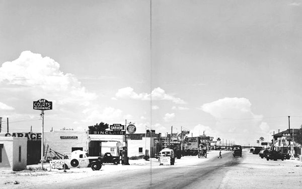
In 1964 there were six gas stations on the north side of the road and four on the south side. Now these stations are all closed.
Landmarks, Route 66 sights
- In San Jon. See below
- Parks and outdoors
San Jon, its Attractions
San Jon is a small town straddling Route 66 and NM-469. It has some old vintage garages and motels, one of them still in operation. It is close to the ghost towns of Endee and Bard, and the Llano Estacado caprock.
We will tour the town from east to west along Route 66.
Circle M Motel
On the NW corner of N 11th St. To your right, it is no longer open.
A one floor building with gabled roof and an L-shape with the buildings at its eastern and western tips higher than the central rooms.
Its sign was very similar to the San Jon's Motel sign, yellow sqares with the word "Motel" written on it.
Then and Now images of the US 66 Circle M Motel in San Jon
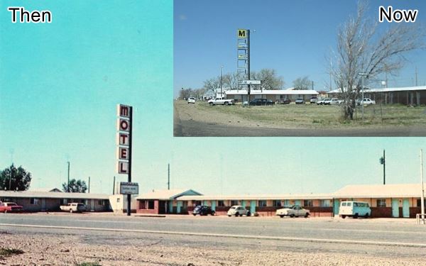

Postcard San Jon Motel ca. late 1960s Source
San Jon Motel
To your right, between 8th and 7th Streets. It was built in 1946, and mentioned by Rittenhouse. It is still the last and the first motel left on Route 66 in New Mexico.
It has an L-shaped layout with a classic neon sign with yellow squares with black letters in them spelling the word "MOTEL".
Unlike the Circle M Motel, this one has one single gabled roof covering all of the rooms.
Both the San Jon Motel and Circle M were operated by Mr. and Mrs. Hoytfellers.
San Jon Motel's neon sign
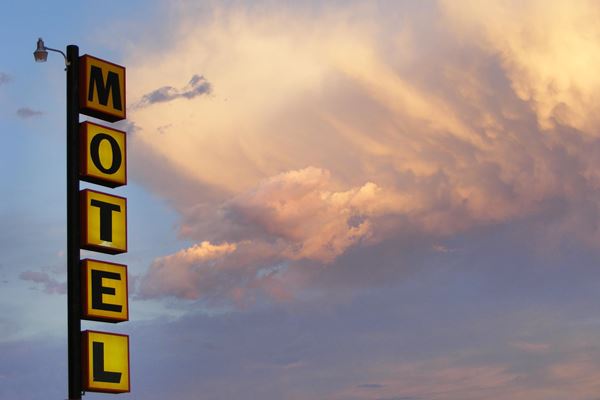
Gas Station Chevron? Mobil? Conoco?

Tokheim 39 short gas pumps.
Across Route 66, on the SE corner of 7th St. is this old gas station (pictured at the top of this page), a cinder block building with an offic to the east and a two bay garage to the right.
It was built in the oblong box style. The office has two windows on each side of the door, and the flat canopy with curved corners and a blue ribbed edge, projects forward over the single pump island held up by two steel poles.
The remains of a Tokheim 39 short model gas pump survive on the island. This type of gas pump was built from 1938 to 1958. Though it lacks the outer metal body, you can see the circular hole on the top of the pump where the glass globe with the brand fitted in. A stainless trim crosses the pump just above the glass bezel that displayed the flowing gasoline.
Under the current white paint, it was painted red (Mobil, Magnolia, Chevron) and also green so maybe it was a Sinclair or a Conoco pump.
The round canopy corners were typical of Chevron, Conoco, Magnolia - Mobil and Sinclair stations of the 1940-1950 period.
The western part juts towards the north, and has a window on the angled wall between the two garage bays.
The garage is the first building on the left side of the image below.
Looking west along US66 in San Jon, New Mexico
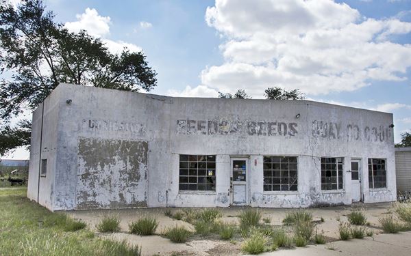
Quay Co. Coop
Across 7th St. on the SW corner is this building with the words "Feed Seeds Quay Co. Coop" painted on it. (second building from the left in the image above).
The Cooperative was incorporated on 22 July 1947, and revoked in 2002. It was listed in San Jon, in the Directory of Consumers' Cooperatives in the United States published in 1949 as: "Post San Jon Quay County Consumers Cooperative Association Highway 66" and handling the following lines: gasoline, other fuels, motor oil, grease, tires, tubes, batteries, automobile accessories, automobiles, trucks. So it was a gas station and a garage.
Quay Co. Coop on Route 66. Notice the walled garage bay door
Former Texaco Station

Three bands on the Texaco building.
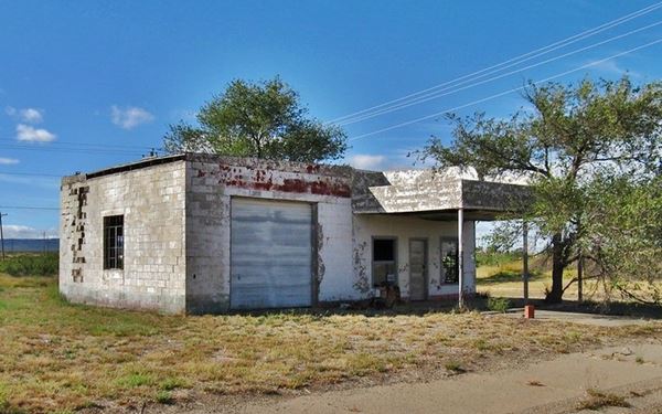
On the next corner (SE of 6th St.) you will see the remains of an old Texaco gas station.
This cinder block building is a Texaco because it has the horizontal roof extensions with rounded corners on the top of the canopy, which also has rounded corners. Also it has the three stripes or parallel bands running along the upper part of the canopy and the building's walls (red arrows in the image).
It had one garage, and was a Type C version designed for Texaco by Walter D. Teague in the mid 1930s.
Old Texaco gas station, notice the tree growing under the canopy
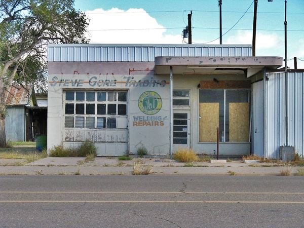
Another Gas Station (Phillips?)
On the NW corner of 5th St. is yet another old gas station (oblong box style built with blocks). The office is closest to the corner, and the garage is to the west. It has a flat roofed canopy held up by slender steel poles over the single island. A large plate glass office window and a Single-door entry topped by transom. This is the style adopted by Phillips 66 in the 1940s and 50s. It is marked as (2) in the map below.
1940s-50s gas station
Facing it, see (1) in the map below, on the NE corner is a brick building with a glass brick window on the rounded corner, a former tavern or cafe. The glass brick corner style can also be seen in Tucumcari at the former Ron dy Voo café, now a church, and at small mall, both on Route 66.
The western facade is decorated with the "Broken Chain Memorial Mural", as a homage to a young man. It reads "Forever in our Heart" 1/26/92 - 5/14/11.

Former cafe or tavern, San Jon.Source

"EAT" Neon sign in San Jon
Smith's Cafe
Marked as (3) in the map below. Across the street, on the south side of Route 66 you will see, on the SW corner of 5th St., the remains in total disrepair, of Smith's Café. The building seems to date back to the 1930s, its windows are broken and there was a neon sign in front of the store, it fell down. It had four white boxes, now illegible.
Unnamed Motel (G & E? Muggs?)

USGS map of downtown San Jon, 1968
Next to Smith's Cafe is an old motel. You can see its L-shaped layout behind a gable roof building that stands on the front of the lot (the offices?). The western wing seems truncated. It appears clearly in the map as (4), L shaped with the office in front.
Several steel poles stand in front of the building, which maybe held the motel's sign.
Next to it is, see (5) in the map, is a former place of worship, now "Shoe String Ceramic Shoppe", followed by the post office building (6).
"Eat" Neon Sign
Turn right along 4th St. and on the third block, to your right is the famous "Eat" neon sign, with white boxes (most signs in town are of this variety). It is pictured above.
Western Motel
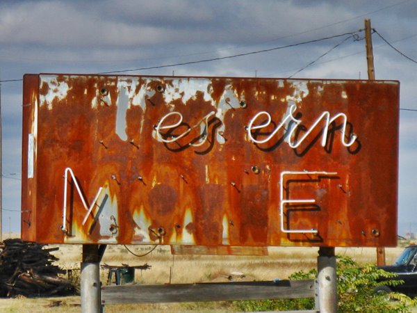
Head back to Route 66 and turn right. On the second block, to your right (7) are the remains of an old motel.
You will see a rusty sign, and a few pink colored cabins with gabled roofs of this 1930s motel. There is a 1963 Plymouth abandoned there too. The western wing of the motel has gone.
Can you read the motel's name?
Old Route 66 Garage
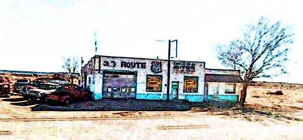
Facing it, (8), on the south side of the highway is an old garage with the words "Wilson Motor Co." on its eastern facade. Maybe a gas station in the Route 66 days, now it is abandoned.
Vintage Route 66 Garage in San Jon, New Mexico
Your city tour ends here.
Outdoors and Nature
Llano Estacado
Roughly 9 miles south of San Jon, along NM-469 is the northern escarpment of the Llano Estacado, Spanish words that mean "Palisaded Plain".
The name originates from the appearance of the high plateau when seen from the surrounding prairies: the caprock appears like a wall, a palisade.
The Canadian River marks its northern border and the Caprock Escarpment, a 300 ft (100 m) cliff surrounds it to the north and east. The Mescalero Escarpment marks its western edge along the Pecos River. Towards the south it blends into the Texan Edwards Plateau.
It is one of the largest mesas (tablelands) in the U.S., roughly 250 miles (400 km) north to south, and 150 miles (240 km) east to west, spanning part of Texas and New Mexico.
Its red sediments are of Triassic and Permian origin.
Ute Lake State Park
25 miles north of San Jon via NM-469 and US-54 to Logan, NM and then NM-540 to the lake. (Map with directions).
Contact: 1800 540 Loop Logan, NM, (575) 487-2284.
The reservoir on the Canadian River is 13 miles long and offers many options for water sports: fishing, boating, swimming. There are campgrounds and RV facilities too.
Route 66 segments near San Jon
These are the sections of Route 66 in San Jon. We describe each of them in a dedicated webpage with maps, itineraries and attractions along the way.
Alignment of Route 66
Sponsored Content

>> Book your Hotel in Albuquerque

Credits
Banner image: Hackberry General Store, Hackberry, Arizona by Perla Eichenblat
Robert Julyan. 1996, The Place Names of New Mexico. UNM Press
Jack DeVere Rittenhouse, (1946). A Guide Book to Highway 66.

