Once it was famous for its Apples
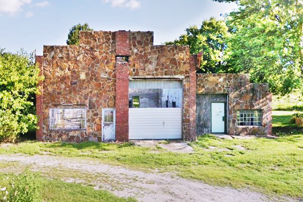
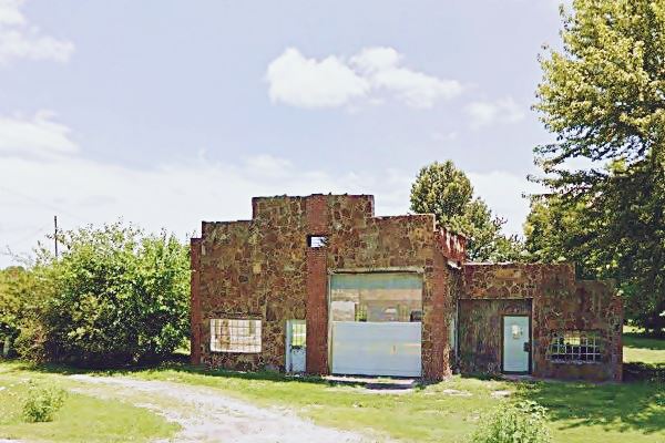
D. L. Morris garage on U.S. 66 in Heatonville MO
Index to this page
- About Heatonville
- Weather
- Hotels close to Heatonville
- Map of US 66
- What to see and do in Heatonville
About Heatonville Missouri
Facts, Trivia and useful information
Elevation: 1,300 ft (396 m). Population n⁄a (2010).
Time zone: Central (CST): UTC minus 6 hours. Summer (DST) CDT (UTC-5).
Heatonville is a small village on Old Route 66 in Lawrence County, in southwestern Missouri.
History of Heatonville
Learn more about the history of this region in our Carthage Missouri web page (or our Halltown MO page).
Lawrence county (named after James Lawrence, naval officer of 1812 War), was created in 1845. The community is located in central Lawrence.
Daniel Heaton settled here and platted a town on his property in 1868, which was named Heaton. The post office adopted the name in 1872 but, in 1881 changed it to Heatonville.
The 1879 the Lawrence County history described it as "a small village situated 6 miles north of Mt. Vernon, on Ozark Prairie, has a drug and dry goods store."
The name: Heatonville
The town was originally named after Daniel Heaton, who founded it. Then the "ville" suffix was added to it.
The surname refers to someone coming from any of the villages named "Heaton" in northern England, name which comes from Old English "Heah" (high) and "tun" (settlement of farm).
It was located on the Ozark Prairie between Phelps and Paris Spring. A railway spur was built to the town to ship out the apples from Williamson's apple orchard.
The first auto trail highway was built through it in 1913 -along the "Carthage Street", and in 1926 Route 66 was aligned along it. This brought an inflow of traffic along the new U.S. highway which lasted until the late 1950s, when I-44 was built, bypassing the village and Route 66 (it ran along former US-166, south of Heatonville from Springfield to Joplin).

Getting to Heatonville
You can reach Heatonville along historic Route 66 or by Interstate I-44 that links it with Tulsa and Oklahoma City in the west and with Springfield and St. Louis in the east. U.S. Route 71 (overlapping I-49) links it with Fort Smith, Arkansas, and Kansas City.
Find your hotel in Heatonville
There is no accommodation in town, but you can find lodging close to Heatonville in neighboring Carthage (west) or in Springfield (east).
> > Book your Hotel in Carthage
Find your room
There are several hotels in the area close to this town. Alternatively you can also find your accommodation along Route 66 in the neighboring towns and cities in Missouri. We list them below (from east to west):
On Route 66's Main alignment in MO
Eastwards
Westwards
- Hotels in Kansas
- Baxter Springs KS
- Galena KS
- Riverton KS
- Hotels in Oklahoma
- Miami OK
>> Check out the RV campgrounds in nearby Carthage or Springfield.
The Weather in Heatonville
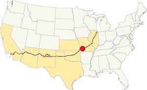
Location of Halltown on Route 66
Winters are cold and dry and summers wet, rainy and hot in Heatonville. The aveage high during July (summer) is 90.6°F (32.5°C) and the average low is 69.1° (21.1°). The January (winter) average high is 44.9°F (7.2°C) and the average low reaches a chilly 25.0°F (-3.9deg;C).
The average rainfall is 46.4 in (1.180 mm) each year, most of it falls during late spring and early summer. Some 12 in. of snow (30 cm) fall each winter.
Tornado risk
Heatonville is inside Missouri's "Tornado Alley", and Lawrence County has some 8 tornado strikes per year.
Tornado Risk: read more about Tornado Risk along Route 66.
Map of Route 66 in Heatonville
The original stage coach route linked Carthage and Springfield through Heatonville. Route 66 was aligned along it in 1926.
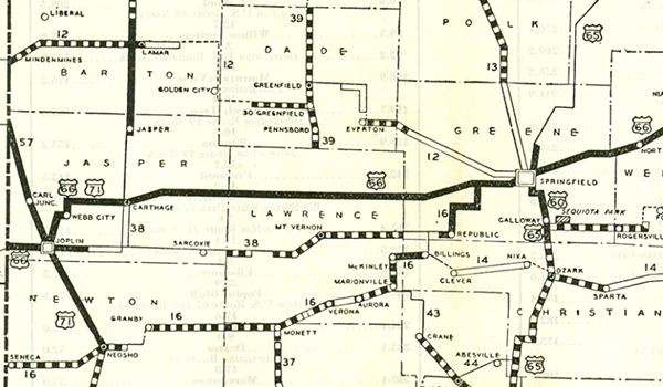
As you head west from Spencer towards Carthage, Route 66 runs in a straight east-to-west alignment for over 30 miles, and it goes through Heatonville.
See this map of Route 66 in the area.
Route 66 Alignment near Heatonville
Visit our pages, with old maps and plenty of information about US 66's alignments.
- Route 66 in Kansas (next)
- Springfield to Joplin (Heatonville's)
Route 66 Landmarks and Places to See
Heatonville and its Route 66 attractions
Historic context: classic Route 66
In his 1946 book "A Guide Book to Highway 66" Jack DeVere Rittenhouse gives us a good picture of Route 66 was like during the post WWII days. Rittenhouse mentions the town as follows.
Heatonville. Garages, groceries, gas stations, general store and Castle Rock Cabins Rittenhouse (1946)
Start your tour on the eastern side of the small community and drive west along U.S. 66, coming from Spencer. To your right is the site of the now razed Jim Collins garage.
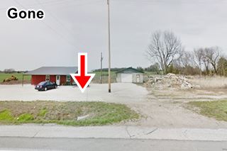
Jim Collins Garage and Law’s Auto Salvage (Gone)
The site of the old garage is loacated at Route 66 (MO-96) and M County Ln, to your right (Map showing location).
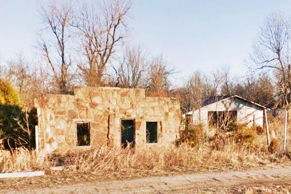
The place has been torn down and a new building stands on the property. The image (2018) shows where the old garage once stood (red arrow); another loss of a classic Route 66 building!
Jim Collins owned it and ran it for many years. It was built around 1935 halfway between Heatonville and Spencer.
The stone slab faced building stood in an abandoned and deteriorated state for many years.
Jim Collins Garage and Law’s Auto Salvage, before it was torn down. Route 66, Heatonville MO
Head west along Route 66 for 1.7 mi. and after passing a large storage tank complex (right) you will see the Castle Rock Courts to your left, on the south side of the highway.
Castle Rock Courts

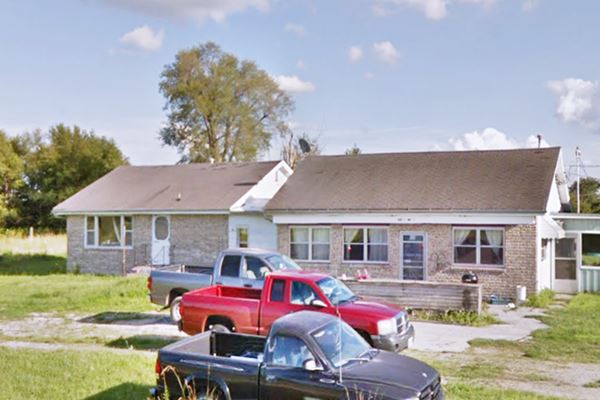
Castle Rock motel rooms. Source
Route 66 (MO-96) (Map showing where is is). Formerly a motel and a filling station that also included a restaurant. It was built in 1931 and Rittenhouse mentioned it in 1946.
The one story building is now a private residence. Its walls that were originally stone faced are now covered with vinyl siding and brick. The restaurant, which was separate structure is now joined to the house.
The motel had three rooms (the building with the rooms is a separate one, behind the ones facing the road).
The place was ran by D.T. Smith. He sold it in 1936 to J. Bynum who in turn sold it to Pat and Irene Chase in 1955. The last owners were Keith and Illene Rhodes who bought it in 1967. It served as a Greyhound bus stop. The building on the right was the cafe and the service station.
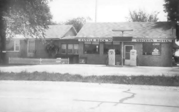
Castle Rock Courts, Route 66, Heatonville MO
Drive west for 0.4 miles to see the last surviving Route 66 classics in town, D. L. Morris garage
D. L. Morris garage
South Side of Route 66, to your left, at (MO-96 and Co Rd 1142). This Garage and Service Station was built in 1936 in local sandstone rubble-typical of the Ozarks. It has a stepped parapet wall.
It was the site of the old post office. The garage closed in the 1970s.
And this ends the sightseeing tour of Heatonville's Route 66 attractions. Head west to visit the next town on your road trip, Albatross.

Some sponsored content
> > Book your Hotel in Lebanon

Credits
Banner image: Hackberry General Store, Hackberry, Arizona by Perla Eichenblat
Jack DeVere Rittenhouse, (1946). A Guide Book to Highway 66
Architectural - Historic Survey of Route 66 in Missouri and Detailed Survey, Maura Johnson. 1993


