Gay Parita's Service Station is here
Gary's Gay Parita Sinclair
Index to this page
- About Paris Springs
- Weather
- Hotels close to Paris Springs
- Map of US 66
- What to see and do in Paris Springs
About Paris Springs Missouri
Facts, Trivia and useful information
Elevation: 1,178 ft (359 m). Population n⁄A (2010).
Time zone: Central (CST): UTC minus 6 hours. Summer (DST) CDT (UTC-5).
Paris Springs is a small village located about half a mile north of Old Route 66 in Lawrence County, in southwestern Missouri.
Real Name: Paris Springs Junction
The community located on the alignment of Route 66 is actually named Paris Springs Junction, and began as a bus stop for the village of Paris Springs that is located off the Mother Road, just north of it.
As almost everyone calls the place Paris Springs, dropping the "Junction" part of the town's name, we will refer to it here using that name.
History of Paris Springs

1929 cutting on Paris Springs.
Credits
Learn more about the history of this area in our Carthage Missouri page.
The county created in 1845 was named after James Lawrence a seaman from the English-American War of 1812.
Water powered flour mills were established here in the mid 1850s. Johnson's Mills was located upstream (at present Spencer). Then water powered saw mill and wool mill owned by O. P. Johnson. After the Civil War, more settlers arrived, and in 1872 Eli Paris had opened a "spa hotel" which used the spring waters in the area, considered to have healing powers. See the image, from the image, a cutting from the "Springfield Leader and Press", 27 May 1929, discussing the high iron content in the spring's water.
The first post office from 1872 to 1874 was named Chlybeate Springs, named after the mineral with a high iron content found in the water. And then changed to Paris Springs.
The name: Paris Springs
Probably derived from the surname of hotelier Eli Paris.
In 1926 Route 66 was aligned along the Ozark Trail and the older Springfield to Carthage road. The road passed 0.25 miles south of the village of Paris Springs, and at the crossroads leading to the village, a small community formed: Paris Springs Junction or Gay Parita. Travel along the U.S. 66 provided income to the town and helped it through the Depression in the 1930s. However the new alignment of Route 66 in 1961 moved the road just beyond its former alignment, and then in the early 1960s, the whole area was bypassed by I-44, which ran along what used to be US-166, south of Paris Springs towards Springfield.

Getting to Paris Springs
You can reach Paris Springs along historic Route 66 and Interstate I-44 that links it with Tulsa and Oklahoma City in the west and with Springfield and St. Louis in the east. U.S. Route 71 (overlapping I-49) links it with Fort Smith, Arkansas and Kansas City.
Your Hotel in Paris Springs, Missouri
Lodging close to Paris Springs find your room in neighboring Carthage or in Springfield
> > Book your hotel in Springfield
More Lodging near Paris Springs along Route 66
There are several hotels in the area close to this town. Alternatively you can also find your accommodation along Route 66 in the neighboring towns and cities in Missouri. We list them below (from east to west):
On Route 66's Main alignment in MO
Eastwards
Westwards
- Hotels in Kansas
- Baxter Springs KS
- Galena KS
- Riverton KS
- Hotels in Oklahoma
- Miami OK
>> Check out the RV campgrounds in nearby Springfield
Weather in Paris Springs
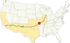
Location of Paris Springs on Route 66
Paris Springs has a wet & subtropical climate with dry and cold winters and very wet summers (the rainy season spans from April to July, with thunderstorms).
Averages rainfall is 46.5 in (1.180 mm) yearly plus some 11.9 in. of snow (30 cm) in winter. The winter (Jan) the average high is 44.9°F (7.2°C) and the average low is below freezing, with 25.0°F (-3.9deg;C). The summer (Jul) average high is 90.6°F (32.6°C) and the average low is 69.° (21.1°).
Tornado risk
Paris Springs is located within the infamous "Tornado Alley" and Lawrence County has an average of 8 tornado strikes per year.
Tornado Risk: read more about Tornado Risk along Route 66.
Map of Route 66 in Paris Springs
Paris Springs Alignment
Click on the thumbnail map to enlarge it. It shows the different alignments west of Halltown through Paris Springs.
- 1926-1960 Alignment. Shown in Green in the image map. See map
- 1960-1977 Alignment. Blue line in the image map. Map
Route 66 Alignment in Paris Springs
Visit our pages, with old maps and plenty of information about US 66's alignments.
- Route 66 in Kansas (next)
- Springfield to Joplin (Paris Springs')
- Rolla to Springfield (previous)
Route 66 Sights in Paris Springs
Landmarks and Places to See on your Road Trip
Historic context, the classic Route 66 in Paris Springs
In his 1946 book "A Guide Book to Highway 66" Jack DeVere Rittenhouse gives us a clear picture of Route 66 was like during that time. Rittenhouse mentions the town as follows.
Paris Springs Junction .... A small crossroads, providing two gas stations and a grocery. Rittenhouse (1946)
Little has changed, those three buildings are still there!
Thinking about visitingt Branson?
Some tours and sightseeing
Sponsored
Tour the route 66 landmarks in Paris Springs
We will begin our tour on the eastern side of Paris Springs, driving west from Halltown.
Log Cabin Mobil Site

1986 aerial photo Log Cabin Mobil, Paris Springs.
Click to enlarge
As you approach Paris Springs from Halltown, you will reach the spot where the 1926-60 and the 1961 alignments take separate courses. Here, to your left, was the old "log cabin" Mobil station.
The image (click on it to enlarge it) loooks south, and shows the original 1926 alignment on the bottom of the image and the 1961 roadbed on the top. The barn to the left has gone, but its rock walls are still standing (see image further down).
The old gas station was torn down but its gravel driveway is still there (see image below).
The place was owned and operated by Dottie Plummer Mason and Glen Mason. The red arrow marks the spot where the old gas station stood.
Glen's cousin Fred bought the gas station further down the road (Gay Parita).
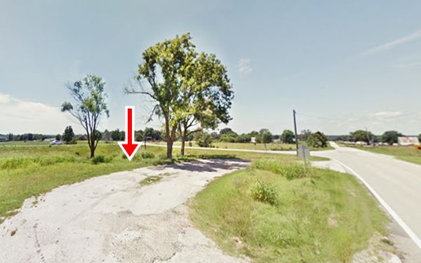
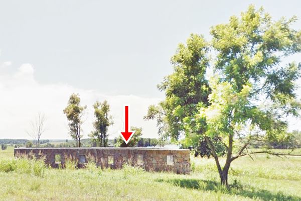
Just ahead, to your left, is the short 250 foot-long road that links the original (now MO-266) and the later (now MO-96) Route 66 alignments. Head straight west into Paris Springs.
After 0.5 miles you will reach the "Junction" at Paris Springs, with all the local sights.
Paris Springs Junction
Gay Parita Service station

Gay and Fred Mason at Gay Parita. Credits
21118 Old 66, Paris Springs Junction, north side of the highway, to your right. You can't miss it.
Also known as Gary's Gay Parita or Gay Parita Sinclair, this is one of Route's 66 major attractions in Missouri.
The service station has a long story. The original Sinclair station belonged to Gay and Fred Mason. Gay E. Sullivan (1888-1953) had married Fred B. Mason (1885-1960) in 1906 and they opened the gas station in 1930, and operated it together.
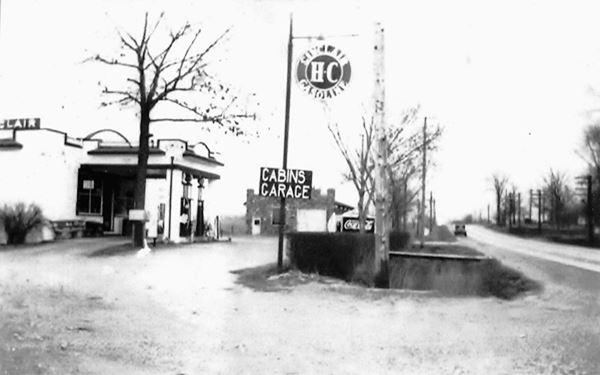
This "original" gas station was a typical Sinclair design of the 1930s. You can see it in the two pictures below.
The first picture shows the staion, pumps, the cabins to the right, and the corner of the old Cobblestone Garage on the far right.
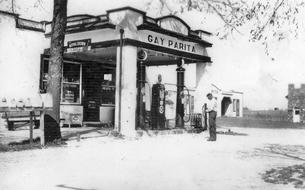
The second image shows Route 66 on the right, the Cobblestone Garage behid the sign, and the gas station with its "Sinclair HC gasoline" and "Cabins Garage" signs.
Gay died in 1953, and the uninsured gas station burned down in 1955. Fred didn't rebuild it, he retired and passed away in 1960. Both Gay and Fred are buried in the Rock Prairie Cemetery, next to I-44's Halltown exit (picture of their headstone).
The Name: Gay Parita
The first part of the name (which you can see in the first picture above) is Fred's wife's name. The "Parita" part of the name is odd, and uncommon.
However, there was a famous ballroom that had the same name, the "Gay Parita Club" in Carona, Kansas, it is pictured below in the 1930s (see its Street view).
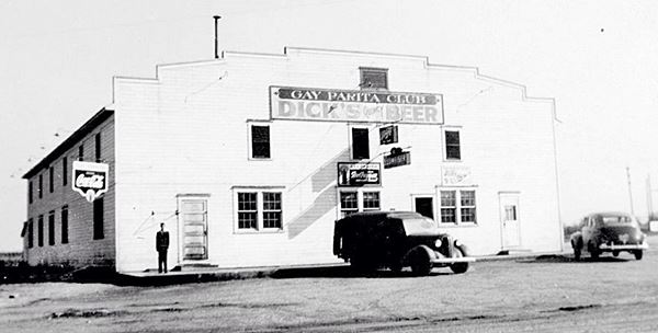
The club in Carona belonged to Joe Ferraro Sr., who opened it in 1934. It was a popular dance hall and ballroom well into the 1980s. Carona is 65 km, as the crow flies, to the west of Paris Springs.
Being of Italian origin, probably Joe Ferraro chose the Italian word "parità" which means equality, or was he inspired by Fred's gas station name? or, did Fred name his station after the ballroom?
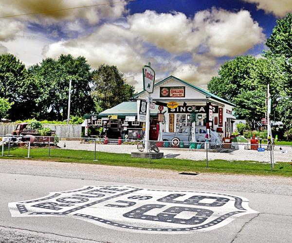
The New Gary Gay Parita service station

Original and Replica Sinclair stations, Route 66 Paris Springs. by Austin Whittall
After the 1955 fire, the old gas station vanished and the property stood vacant for many years until Gary Taylor (1944 - 2015) and his wife Lena Faye Call moved to the Paris Springs area with their children in 1979. They wound up buying this piece of land from relatives who owned the property.
According to their daughter Barb Turner Barns, her uncle Steve and her cousin helped build the place back in 2005.
It isn't an exact replica of the original building, as you can see by comparing the old and new photos.
1930s Sinclair style
The stations had a distinctive design: pent roof with green tiles and the canopy was solid, with a raised parapet supported by strong box-like stucco columns. They were built in a Mission or Spanish Eclectic style. See this example on Route 66 in Tulsa
Gary's Sinclair station
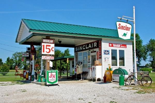
The new service station was built in a Craftsman style. With a low-pitched gable roof that extends form the office over the pump island. It has a wood-like exterior finish and is smaller and leaner. Many brands like Texaco or Standard Oil used this style but with hipped roofs.
Route 66 Shield on the roadway
Don't miss the large U.S. Highway 66 shield painted on the roadway. It is one of many painted along the Mother Road. Be careful if you plan to take a picture next to it!
Read more about the Shields painted on Route 66.
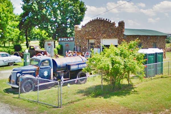
Paris Springs Cobblestone Garage
To your right, on the eastern side of the property, next to the famous service station.
A single bay garage built ca. 1926 in rough cobblestone, with a half-round metal roof. This is one of the two garages mentioned by Rittenhouse.
Notice its rough, ragged parapet (those prominences across the top of the wall), it predated the gas station and was built the same year Route 66 was created.
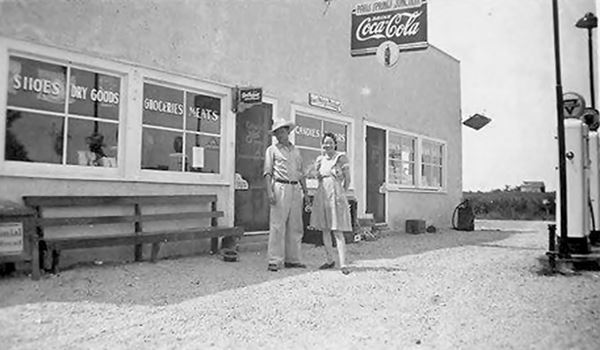
Gay Parita Store
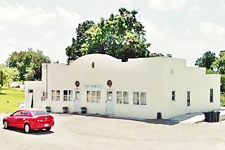
Across the street, to your left it is located in front of the service station, on the south side of the road.
This is now a private residence, and was built in 1930. It is a stucco building, with one-story. It was built in a Spanish - Mediterranean Revival style with a curved parapet.
The Architectural - Historic Survey of Route 66 says that this store was owned by Gay and Fred Mason. However, Willie Washam says that Glen and Dottie Mason (who owned the "Log Cabin Mobil") built this store in 1940 and lived there too. They sold groceries, animal feed and clothes apart from Conoco gasoline. They then sold it in 1945 to the Taylors. The man with the hat in the following image is Glen Mason.
Ahead, also to your left is the second garage in Paris Spgs.
The other Paris Springs Garage
On the south side of US66, to your left, just west of the junction.
Built around 1944, this was the second service station mentioned by Rittenhouse, it is built in stone, and is a single-bay garage with a half-round metal sheet roofing. It is pictured below.
1923 Route 66 Bridge
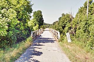
There is a very old bridge, almost 100 years old!. It was built in 1923, between Paris Springs and Spencer. It crosses Turnback Creek; it is a triple pony-struss bridge, pictured above.
Your city tour of Paris Springs ends here, continue straight and visit neighboring Spencer, enjoy your Route 66 road trip.

Some sponsored content
> > Book your Hotel in Lebanon

Credits
Banner image: Hackberry General Store, Hackberry, Arizona by Perla Eichenblat
Jack DeVere Rittenhouse, (1946). A Guide Book to Highway 66
1879 map of Paris Springs, Lawrence County history
Architectural - Historic Survey of Route 66 in Missouri and Detailed Survey, Maura Johnson. 1993


