Route 66 in Helendale CA
Index to this page
All about Helendale
Facts, Trivia and useful information
Elevation Elevation 2,430 ft (740 m). Population 6,962 (2025).
Time zone: Pacific (MST): UTC minus 8 hours. Summer (DST) PDT (UTC-7).
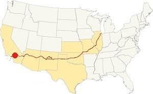
Helendale is a community located on Route 66, in south western San Bernardino County in the south of California, on the Mojave River.
The History of Helendale, California
Visit our Barstow web page to learn more about the early history of this area.
Elmer's bottle Ranch on Route 66
The Mojave Trail was opened around 1780 as a route that linked Spanish California with the other Spanish colonies in Arizona and New Mexico. It crossed the Mojave desert north of the modern I-40 and US 66.
Mojave Trail or Mojave Road
The Native Americans had used a trail from Cajon Pass (a gap between the San Bernardino and San Gabriel Mountains in the south) to the Colorado River, following the Mojave River across the Mojave Desert. During his mission to Arizona, Father Garces used this route back in 1776.
The first American to trek it, westbound, was Jedediah Smith, who came from Utah in 1826 five years after Mexico had become independent from Spain, and inherited the Spanish colonies.
By the late 1820s, Mexican traders in New Mexico opened the "Old Spanish Trail" which met the Mojave Trail at Soda Lake in the Mojave.
During the Mexican-American War (1846-48), the Mormon Battalion camped at "Point of Rocks", the site of present-day Helendale. After its defeat by the U.S., Mexico
ceded these territories to the US.
Settlers from the east moved to California and many Mormons settled along the "Mormon Corridor", a name given to areas settled from 1850 to 1890 by the members of The Church of Jesus Christ of Latter-day Saints, commonly known as Mormons. The Mormons bought the San Bernardino ranch in 1851 and founded the town of San Bernardino there.
There were many way stations located along the Mojave River in the 1870s: at Oro Grande and another near Helendale known at that time as "Point of Rocks", which was operated by the Saunders family which is modern Helendale, followed by another at Cottonwood (now Hodge).
The Railroad in Helendale
In 1881 the Southern Pacific Railroad (SP) extended its line from Bakersfield east after silver was found near modern Barstow at Calico. SP continued its line all the way to Needles to block the entry into California of its rival the Atlantic & Pacific Railroad (A & P) a company which later was absorbed by the Atchison Topeka & Santa Fe Railroad.
In the meantime A&P laid their tracks across Kansas, New Mexico and Arizona and after crossing the Colorado River, reached Needles in 1883. They did not stop there and the following year, they threatened to build a line parallel to that of SP and forced them to sell the Barstow-Needles railroad. Once in Barstow, A&P turned south and built a line along the Mojave River following the old trail, and across Cajon Pass into San Bernardino. They completed it in 1885.
The railroad built a station as a watering stop for its steam-powered locomotives, and named it "Point of Rocks".
Helendale, the name
The station and depot were renamed after the daughter of the railroad's vice-president (Helen Wells): "Helen" in 1897. However, it was changed again, 21 years later to "Helendale" (A "dale" is a valley).
In the early 1900s, the use of the automobile began to grow and better roads became necessary. The National Old Trails (N.O.T.) planned a road from Los Angeles to New York, and they aligned it next to the AT & Santa Fe railroad tracks from Cajon Pass to Needles. The road passed through Helendale.
Route 66 was aligned along the N.O.T. when it was created in 1926 and ran along it until I-15 bypassed it in 1958.
After WW II, traffic grew and reached 1.1 million travellers in the mid-1950s. All of them driving through Helendale. The highway was becoming overcrowded and the Interstate system created in 1958 would soon bypss both US 66 and US 91 in this part of California.
Travellers started to use I-15 and I-40, bypassing Helendale for good.
Two artificial lakes were built at Helendale in 1969, covering 277 acres (1.120 ha), and a resort community named "Silver Lakes" was developed along their shores. They are located just west of the Mojave River and Route 66.

Accommodation in Helendale: Where to Stay
There is no lodging in Helendale; check out the hotels and motels in neighboring Barstow or Victorville to find your room.
> > Book your Hotel in Barstow or in Victorville
More Lodging Near Helendale along Route 66
Below you will find a list of some of the towns along Route 66 east and west of Helendale; click on any of the links to find your hotel in these towns.
>> Check out RV campground nearby in Barstow and Victorville
The Weather in Helendale
Location of Helendale on Route 66
Helendale has a semi-arid climate, winters are cool and summers are very hot. Rainfall is scarce and snow is extremely rare. The Average temperatures (high) are: Summer (Jul) 98°F (37°C) and Winter (Jan) 61°F (16°C). And the average Low is, in summer (Jul) 62°F (17°C) and (Jan), winter: 30°F (-1°C).
Rain averages 5.5 in. per year (145 mm) with the driest months being May to Oct (less than 0.2 in monthly - 5 mm).
Tornado risk
Helendale is located well to the west of the Rocky Mountains, so there is no risk of tornadoes in this part of California.
Tornado Risk: read more about Tornado Risk along Route66.
Map of Route 66 in Helendale
From the N.O.T. Highway to U.S. 66
Read about the Barstow to Pasadena alignment in our dedicated webpage. Below is an interactive map of this section:
Map of this segment in Helendale.

1927 Road map, SW CA
Click on image to enlarge.
Credits

1956 Shell Roadmap, SW CA
Click on image to enlarge.
Credits
National Old Trails Highway (N.O.T.)
Helen Station appears in the 1927 roadmap.
The 1912 map of the Automobile Club of Southern California's (ACSC) from Barstow to Victorville shows no sign of Helendale, mentioning only Todd, 8 miles south of Barstow followed by Cottonwood (later Hodge) another 8 miles away. These were followed by Oro Grande 17 miles to the south, and Victorville (5 mi.), which did have "Gasoline."
There was another road between Barstow and Victorville through Stoddard Well, which would be the route adopted by I-15 when it was built half a century later.
Shortly after, in another ACSC map, Oro Grande offered "Gasoline-Oil", and Helen Station (which would later become "Helendale") had appeared 10 mi. north of Oro Grande. Hicks figures on this map but Cottonwood had gone. By 1915 Victorville offered "Meals - Lodgings, Gasoline - Oil. Garage Repairs".
In 1915 the road linking San Bernardino with Barstow through Cajon Pass became California highway LRN 31, San Bernardino County upkept it until the mid-1920s.
In 1926, the N.O.T. highway became part of the US highway network and the section west of New Mexico became US 66. Despite this, Route 66 was known as the "National Old Trails Road" for many years in California.
See this Map from Barstow to Helendale.
Route 66 Alignment near Helendale
With maps and full information on the Mother Road.
- Pasadena to Santa Monica (Next)
- Barstow to Pasadena (Helendale's)
- Topock to Barstow (Previous)

Sights and Attractions in Helendale
Helendale and its Route 66 sights and landmarks
Jack Rittenhouse wrote about Helendale in his Giuidebook to U.S. Highway 66 published in 1946; he said:
HELENDALE... In one building here are the post office, store, and gas station. Nearby is a state highway maintenance station... Rittenhouse (1946)
The "Guide to the Golden State" published in 1939 by the WPA Book also mentions the town:
HELENDALE, 21.8 m. (2,424 alt., 150 pop.), is encompassed, oasis-like, by waving alfalfa and corn. Beyond the cultivated circle of the Helendale district, the tawny desert spreads away. SHADOW MOUNTAIN, holding turquoise- bearing porphyry deposits that were worked by desert-dwelling Indians predecessors of the Mojave looms indistinctly on the western horizon (R) of HELENDALE MESA WPA (1939)
Helendale leg of your Route 66 Road Trip
Driving west from Hodge the highway skirts the north slope of a mountain range heading towards the Mojave River, and as it reaches the railroad, it turns south and runs close to it. Here, after the curve to the south was the old Helendale Depot to your right, some buildings including the old schoolhouse where the trees grow. Nothing remains of them. This 1952 aerial photo shows the spot.
To the left is a classic service station, Burden.
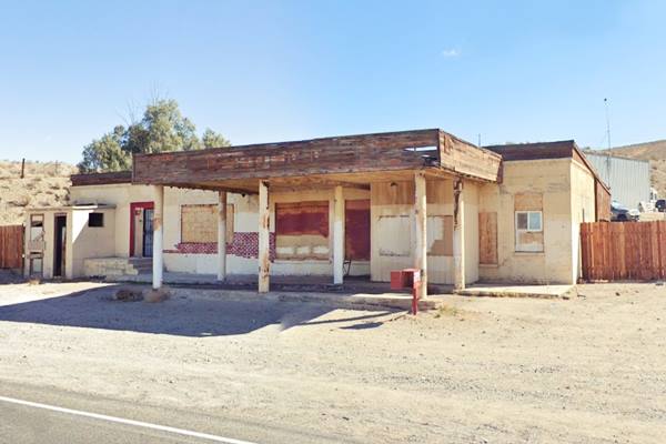
Burden's Store and Post Office
Walter Trickey who was also Helendale's postmaster, had a store here that also sold Red Crown gasoline. He sold it to J. W. Burden, an "agriculturalist" from Newberry Springs in 1926. Burden's son, Charles, ran the store and post office.
It is on your right (eastern side of the road). It was built in 1926 in brick after his first wood-frame store burned down. It was located in what used to be the center of Helendale on the brand new Route 66 alignment.
The old Burden's Store in Helendale nowadays
The Mojave River is just half a mile west, beyond the railroad tracks. It is dry most of the time, but you can get to see it from the bridge on Vista Rd. that forks from Route 66 0.8 miles ahead and leads to the modern community on the west side of the Mojave, Silver Lakes.
Mojave River
The Mojave River is located roughly half a mile west of Hodge. It is an itermitent river that flows in a closed basin with an area of 4,580 sq. mi. (11.862 km2), its source is in the San Bernardino Mountains at almost 3,000 ft. altitude (900 m) and it discharges into Soda Lake, in the Mojave Desert.
It is a source of water used by the desert animals and plants, and also by those crossing the Mojave since prehistoric times.
110 mi long (177 km), its discharge varies from nil to a maximum of 70,600 cu. ft. (2.0000 m3). Most of its water flow is underground as the river bed is dry most of the year.
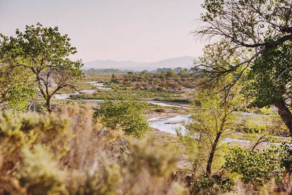
Father Garces named it Arroyo de los Mártires (Martyrs' Creek) in 1776. When Jedediah Smith followed it westwards into California in 1826 he named it "Inconstant River".
The underwater course of the Mohave River was marked by vegetation growing next to it, and therefore was in sight of Route 66 and the SF Railroad from Newberry to Victorville.
Polly Gas Station Sign
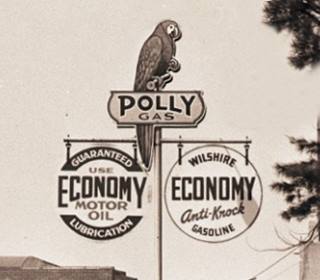
1935 Polly gas station in Santa Monica CA. Source. Click to enlarge
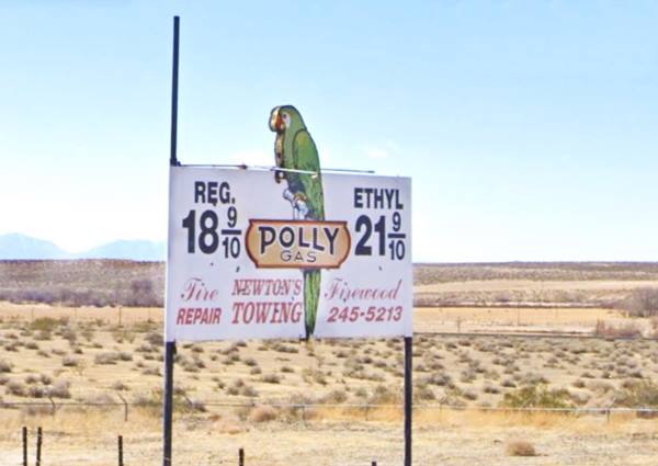
To your left, 0.1 mi. south, after passing the gas station and the store and bar, is the site of Watson's Polly gas station. The store was originally known as The Gables, and the tiny building's gable roof, single-story building next to it, on its north side at 26464 N.O.T. Hwy is the former Helendale Post Office that operated here between 1957 and 1986.
The Polly station was torn down long ago, and the site is marked by the concrete foundations of the building. As the parrot on the sign indicates, Polly was a parrot and the symbol of the gasoline brand owned by Wilshire Oil Co., which was based in Los Angeles and sold gasoline in southern California between 1914 and 1960.
The company was acquired that year by Gulf and the Wilshire brand disappeared in the mid-1960s.
Polly Oil was incorporated ca. 1920 and acquired by Wilshire in 1929. It was sold at Wilshire filling stations until the mid-1950s. Their ads from the 1940s proclaimed "POLLY GAS THE POLYMERIZED GASOLINE."
The Polly gas station at Helendale was owned by Dr. William Watson and went broke when I-15 opened, but fortunately, the original sign was restored and is still there, displaying oil prices of the 1950s.
Polly the parrot
Polly is the diminutive of "Poll", which in turn is derived from "Moll", a familiar form of Mary. And Polly is the name traditionally given to parrots. The oldest use on record dates from 1616 in Ben Johnson's "Epigrams".
Watson's Richfield Station
Drive west, for 0.8 miles and to your right is the former Watson's Richfield Station at 25779 Nat. Trails Hwy.
It has a flat canopy over a single pump island and a glassed office facing the highway. Simple lines, no service bays facing the highway, instead, the single garage bay was on the rear part of the main building. It dates back to the late 1940s. It was nicely restored in the early 2000s.
The sign is gone but would have been located on top of the canopy, lengthwise.
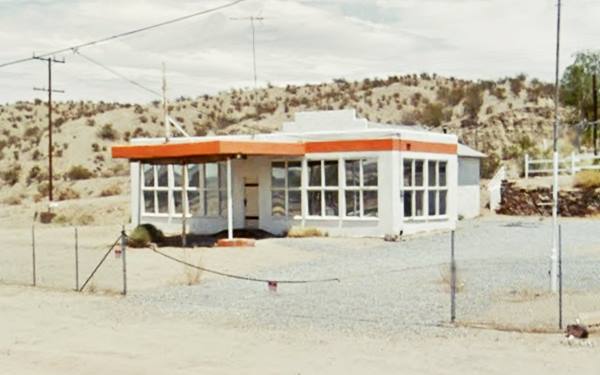
Ran by Dr. Watson (who also owned the Polly Gas station further east) and his wife, Annette. It too closed when traffic dropped after the freeway opened between Barstow and Victorville in 1958.
Continue towards the west for one mile, to your left is a former Cafe and Motel.
White Orange Cafe and Motel
At 24949 N.O.T. Hwy, on the eastern side of the highway. It was run and owned by James G. Blaine and his wife. It dates back to the mid-1940s. The motel is a long, narrow building with several units located on the back of the property. It can be seen from the highway (St. view). This is an aerial photo from 1952. Now it is one of Molly Brown's Country Cafes. It has added a windmill with a Route 66 sign on it.
Sage Brush Inn
Five hundred feet west, to your right, is the classic Sage Brush Inn that was also a roadhouse (tavern, dance hall, club), as it was located beyond Helendale's city limits. It is said to have also served as a brothel, but that isn't true.
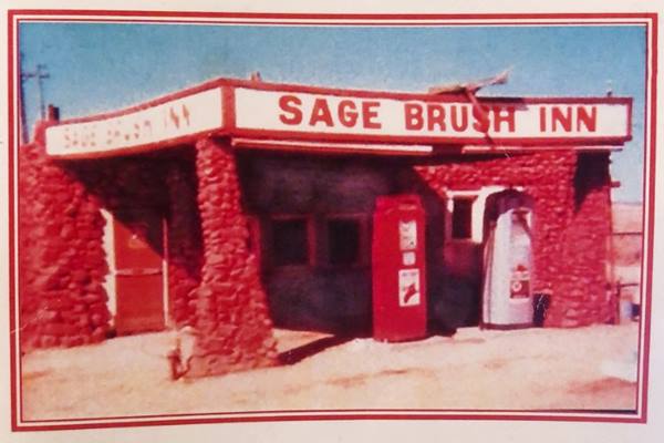
George Sibert (1886-1943) moved to the area in 1930 and opened the Sage Brush filling station. It was built by a local, Guy Wadsworth in stone. Wadsworth was a veteran of the 1898 Spanish-American war. During the prohibition, he was a bootlegger.
Sibert added a bar - café and dance hall to the service station in 1934. He sold cold beer and ran the place with hsi wife Elizabeth Louise "Bessie" Sibert nee Russell (1882 - 1970). Bessie was also known as "Sagebrush Annie".
The place became known as the Sage Brush Inn (Sagebrush is a shrub, of the daisy family that grows in the dry areas of western North America).
The building survived, but is now private property (1).
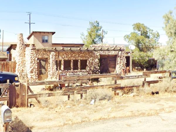
In a now vacant lot to your left, opposite the Sage Brush, was Bessie's sister-in-law's nephew's beer bar run by him, Harold Winters, and his wife Anita. They had a 36-foot-long bar.
Bottle Tree Ranch
Bottle Tree Ranch. Source. Click to enlarge
A Must See Stop on Route 66
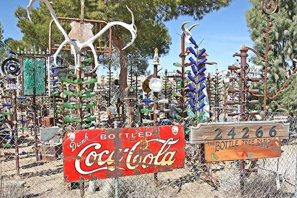
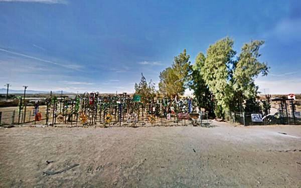
Drive west for 0.9 miles and at 24266 National Trails Hwy, to your right is this classic Route 66 landmark. see map with directions.
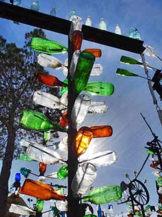
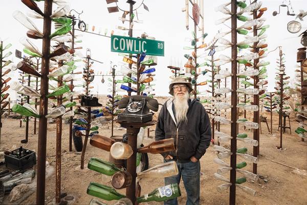
Elmer Long, who passed away in 2019 at the age of 72, created this "bottle tree ranch" using his deceased father's collection of bottles. It consists of some two hundred scrap metal trees with bottles on the welded branches.
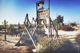
Mahan's Hulaville. Source. Click to enlarge
Source of Inspiration
Elmer's inspiration appears to have been the now closed and gone "Hulaville Forest" (or Mahan's Half Acre) formerly on I-15 near Hesperia, that also had wine and beer bottle sculptures created by Miles Mahan (1896-1997). It was torn down shortly after Mahan's death.
Some of Mahan's works of art (the Hula Girl, the Howdy cowboy) were saved and are on exhibition at the California Route 66 Museum in Victorville.
Elmer Long's forest of scrap metal pipes and bottle "leaves" is a homage to Mahan's site and a classic Route 66 icon. A "must see sight".
Elmer was sure that his work would endure: "This is just going to sit like a gem in the desert, someday after I'm gone" Long said (1).
The Potapov's Service Station ❌
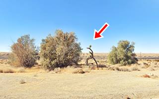
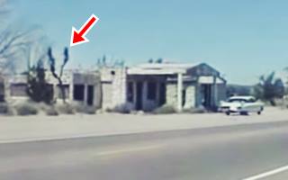
Drive west for 0.2 miles and after crossing Turner Rd., to your right is the site. A large Joshua tree marks the spot where Potapov's Service Station and auto court once stood (red arrow in the "Then and Now" images below).
It had been built around 1931, by Guy Wadsworth (it was another of his stone creations) and was torn down in 2007 due to safety concerns. Some rubble remains at the spot.
The Joshua Tree marks the exact spot. This plant belongs to the genus Yucca, and got its name from the Mormon settlers in the mid-1800s. The tree's shape reminded them of Joshua reaching up to heaven in prayer.
Route 66. Source(click to see video)
Head west for 450 feet, to your right is the building that housed Elva's Malt Shop. It was built after WWII by local rancher K. T. Smith and ran by his wife. It also sold orange juice. It was named for their daughter St. view.
Continue your Road Trip
Your journey through Helendale ends here.
Continue your "Route 66 Road Trip" by heading west towards the next stop along the highway: Oro Grande.

Sponsored Content
>> Book your Hotel in Victorville

Credits
Banner image: Hackberry General Store, Hackberry, Arizona by Perla Eichenblat
Richard D. Thompson, The Story of SAGEBRUSH ANNIE AND the SAGEBRUSH ROUTE...
A Guide to the Golden State, by the Federal Writers' Project of the Works Progress Administration, Hastings House, New York, 1939.
Jack DeVere Rittenhouse, (1946). A Guide Book to Highway 66.


