Route 66 in Lenwood CA
Index to this page
About Lenwood California
Facts, Trivia and useful information
Elevation 2,277 ft (694 m). Population 4,134 (2025).
Time zone: Pacific (MST): UTC minus 8 hours. Summer (DST) PDT (UTC-7).
Lenwood is a small community located on Route 66, in south western San Bernardino County, in the south of California.
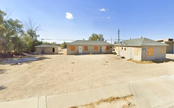
The History of Lenwood
Visit our Barstow web page to learn more about the early history of this area.
In 1780, the Mojave Trail was opened, linking California with Arizona, New Mexico and Utah. It crossed the Mojave desert north of the modern I-40 and US 66, following the Mojave River.
Mojave Trail or Mojave Road
The Natives used a trail from Cajon Pass, a gap between the San Bernardino and San Gabriel Mountains in the south, that reached to the Colorado River in the east along the Mojave River and a series of water holes across the Mojave Desert.
Father Garces used the trail during his mission to the Hopi Indians in Arizona in 1776.
Jedediah Smith was the first American to use it westwards, from Utah in 1826, a few years after Mexico became independent from Spain (1821) and California became part of its territory.
By the late 1820s "The Old Spanish Trail" had been opened by Mexican traders in New Mexico and it linked with the Mojave Trail at Soda Lake, the drainage point of the Mojave River.
The US defeated Mexico in the 1846-48 war and California became a state of the Union in 1848.
The Mormons expanded west settling along the "Mormon Corridor" (areas settled from 1850 to 1890 by the members of The Church of Jesus Christ of Latter-day Saints, commonly known as Mormons), and they purchased the San Bernardino ranch in 1851, founding the town with that same name. San Bernardino County was formed in 1853.
The US Army Lt. Edward Fitzgerald "Ned" Beale surveyed a wagon trail to California in 1857, that crossed the Colorado River close to Needles linking up there with the Mojave Trail. A steady inflow of settlers used this Mojave Trail.
Several way stations operated along the Mojave River in the 1870s, one was located near present Oro Grande, another near Helendale (at that time known as "Point of Rocks") ran by the Saunders. Followed by Cottonwood (present Hodge), ran by the Lightfoots. Barstow was the next one (known then as "Grapevines").
The Railroad in Lenwood
The Southern Pacific Railroad (SP) extended its line from Bakersfield east after silver was found near modern Barstow, then they built the line to Needles, meeting their rival, the Atlantic & Pacific Railroad (A & P) there. The A&P had built their tracks across Kansas, New Mexico and Arizona, reaching Needles in 1883. In 1884 they threatened to build a line parallel to that of SP and thus forced their competitor to sell them the line from Needles to Barstow.
A&P extended its line to San Bernardino through Cajon Pass in 1885 and followed the Mojave River south, along the Mojave Trail, but no siding was built at Lenwood.
A Town born from speculation
Frank Woods and his wife Ellen subdivided a plot of land of 1,540 acres that they owned, west of Barstow. It worth around $17,000 and to develop it, they established the Lenwood Estates ran by William Barnard, an insolvent character who in turn set up the fictitious Arizona-California Land Company to sell it to gullible investors during the 1920s real estate bubble.
There was an agreement between Barnard and the Woods to subdivide the land, sell it promising improvements, and reap some $200,000 for the three of them. The intention, as proven later in court, was to cheat and defraud investors because they abandoned the scheme without building the promised improvements, defaulting on the building materials supplier and the bank. They lost their case in court, but the town finally survived and prospered, linked to Route 66 which was created shortly after.
Lenwood, the name
The name was the brainchild of Frank Woods, who adapted it from his wife's name (Ellen) and his surname (Woods) so "Ellen Woods" became "Lenwood".
In 1926, the dirt-surfaced N.O.T. highway that linked Los Angeles with New York and ran through Lenwood became part of the US highway network as U.S. Highway 66. Nevertheless, Route 66 was known as the "National Old Trails Road" for many years in California. Lenwood found itself on a new highway.
Lenwood was too close to Barstow so it remained stunted.
After the war, traffic along Route 66 grew peaking in 1960: over 1.1 million travellers passed through Lenwood that year. A new safer road was needed and it was finally built: I-15 and I-40 the interstate highways replaced both US 66 and US 91 in this area.
This hurt many of the Route 66 motels and shops catering to travellers in Lenwood and the town refocused towards the Interstate.

Where to Stay in Lenwood: Accommodation
There is no lodging in Lenwood; check out the hotels and motels in neighboring Barstow to find your room.
> > Book your Hotel in Barstow or in Victorville
More Lodging Near Lenwood along Route 66
Below you will find a list of some of the towns along Route 66 east and west of Lenwood; click on any of the links to find your hotel in these towns.
>> Check out RV campground nearby in Barstow and Victorville
The Weather in Lenwood
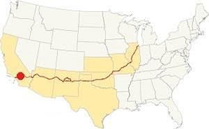
Location of Lenwood on Route 66
Lenwood has a desert climate, winters are cool and summers are very hot. Rainfall is scarce.
Average temperatures (high) are: Summer (Jul) 99°F (37°C) and Winter (Jan) 60°F (16°C). And the average Low is, in summer (Jul) 62°F (17°C) and (Jan), winter: 32°F (0°C).
Rain averages 6.3 in. per year (161 mm) with the driest months being May to Sep (less than 0.2 in monthly - 5 mm). Snow is very rare.
Tornado risk
Lenwood is located well to the west of the Rocky Mountains, so there is no risk of tornadoes in this part of California.
Tornado Risk: read more about Tornado Risk along Route66.
Map of Route 66 in Lenwood
Read about the Barstow to Pasadena alignment in our dedicated webpage. Below is an interactive map of this section:
Map of this segment in Lenwood.
The first alignments and Route 66 after 1926

1927 Road map, SW CA
Click on image to enlarge.
Credits

1956 Shell Roadmap, SW CA
Click on image to enlarge.
Credits
National Old Trails Highway (N.O.T.)
In the early 1900s, the use of the automobile began to grow and better roads became necessary. The National Old Trails (N.O.T.) planned a road from Los Angeles to New York, and they aligned it next to the AT & Santa Fe railroad tracks from Cajon Pass to Needles. The road passed through what would later become Lenwood.
The Automobile Club of Southern California's map of 1912 from Barstow to Victorville shows no sign of Lenwood because the town was established after 1923; and only mentions Todd, 8 miles south of Barstow followed by Cottonwood another 8 miles away. The next town is Oro Grande 17 miles to the south, followed by Victorville (5 mi.), which had "Gasoline."
There was another road, through Stoddard Well that would later be the route adopted by I-15.
The next map shows that Oro Grande offered "Gasoline -Oil", and Helen Station had appeared 10 mi. to the north. Hicks appeared on the map too, and Cottonwood had gone.
By 1915 Victorville offered "Meals - Lodgings, Gasoline - Oil. Garage Repairs". In 1915 the road linking San Bernardino with Barstow through Cajon Pass became California highway LRN 31, San Bernardino County maintained it until the mid-1920s.
The N.O.T. guidebook published in the 1920s had nothing to say about Lenwood it only mentions Oro Grande.
Route 66
The dirt surfaced N.O.T. Hwy became Route 66 in 1926, and it shared the alignment with U.S. 91. It was paved in the 1930s and runs in a straight line from Barstow to Lenwood as shown in this Map. It is a 5.5-mile drive. The highway remained aligned along this roadway until it moved to the freeway (I-15) in the mid-1960s. And in 1973 the highway's Western Terminus was moved to Needles. The era of Route 66 ended in SW California with this change.
Route 66 Alignment near Lenwood
With maps and full information on the Mother Road.
- Pasadena to Santa Monica (Next)
- Barstow to Pasadena (Lenwood's)
- Topock to Barstow (Previous)
Getting to Lenwood
You can get to Lenwood along old Route 66 which here is named "Old National Trails Highway". Also from I-40 in the northeast or from I-15 at Exit 178 (north, east and south).

Sights and Attractions in Lenwood
Small Route 66 town in the Mojave
Historic Context
In his 1946 Guidebook to Route 66, Jack Rittenhouse mentioned three auto courts, the Radio, Lenwood and West Barstow; he also said there were two cafes and the Lenwood Garage.
In 1939, a "Guide to the Golden State" written by the WPA described the area as follows:
...South of BARSTOW, US 66 runs through billowing desert country; only the cottonwoods and willows on the banks of the Mojave River (R) relieve the tedium of rolling sandscape. LENWOOD, 5.2 m. (2,229 alt., 200 pop.), is encircled by slate-colored elevations blanketed with desert growths. In the surrounding country are a few sprawling alfalfa fields and an occasional chicken ranch. WPA (1939)
Road Trip leg in Lenwood
Tomahawk Trading Post
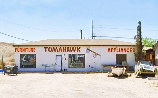
It is only a 5-mile drive away from downtown Barstow to Lenwood and for this reason the village never grew into a full-blown town. But it has its share of Route 66 sights. After passing beneath State Hwy 58 along the Main St. underpass, you will reach Lenwood. Ahead, to your left at 25677 W Main, is the first building in town, Tomahawk furniture and appliances that has been here since 1957, it began as a Trading Post (1).
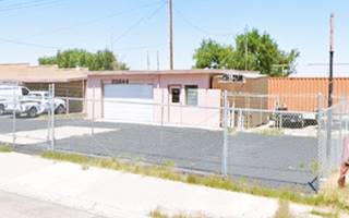
Just 120 yards, ahead, across the street to your right there was a gas station before the 1970s, the Fargo gas that was probably located at 25644 West Main (pictured below), followed by a Richfield gas station just before Gusto's Bar, also to your right. We haven't managed to identify the latter, maybe 25600 W Main (?)
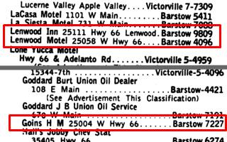
1959 Yellow Pages, Lenwood. Source
Most of the buildings along Route 66 don't belong to the golden age of Route 66. The Lenwood Inn at 25111 W Main is now a vacant lot opposite the Community Church, some trees mark the spot. Had this also been the site of the famous Lenwood Radio Camp was mentioned by Rittenhouse in 1946? It does not appear in the late 1950s phone book, only one record from The San Bernardino Sun issue of March 31, 1949 mentions that Homer D. Luring owned the Radio Auto Camp (3), indicating it was still open at that time. But, where was it? The 1952 aerial photo shows the layout with cabins and buildings facing Route 66 in a shady area with trees at 25111 W Main.
Lenwood "Radio Auto Camp" ❌
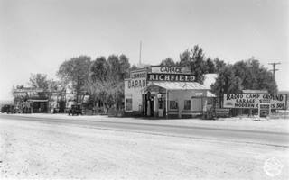
1935, Radio Camp Lenwood. Source.
Click to enlarge
It offered cabins, camping, and a cafe with a grocery shop and beer garden. Click on the thumbnail image to get a full-sized picture; it shows the buildings on the south side of the highway in 1935. Its postcard below stated "5 mi. west of Barstow Coolest spot on the Desert - Free Lunch Tables."
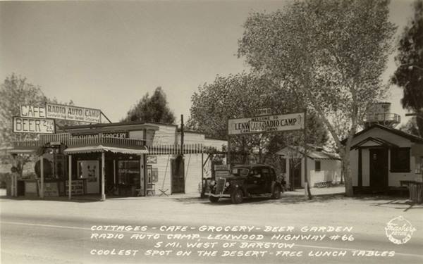
Nothing remains of the campground; its cabins are gone.
1935 photo by Burton Frasher captioned "Radio Auto Camp, Barstow, California"
Lenwood Motel ❌
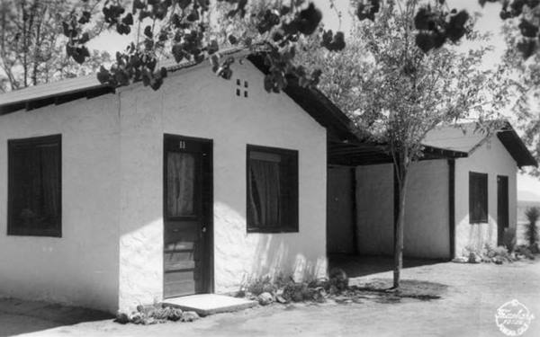
There are no postcards of this motel, we only habe the reference given by Rittenhouse in 1946, the 1959 yellow pages entry placing it at 25058 West Main, and an advertisement published in Sept. 1945 when it was put up for sale and described as follows: "Motel, Garage, Coffee Shop. Hiway 66, 5 miles S.W. of Barstow. 10 units, 5 modern stuccos, five 1 & 2 rm. housekeeping frame cabins, all rented. garage. 2 pumps service station, rented coffee shop 8 stools... 300 ft. hiway, shade trees, shaded sites to build more cabins... $25,000, 1⁄2 cash. Owner, Lenwood Motel" (2).
The motel is gone, and Goins Gas station on the west corner (25004 W Main) also. Now there is a gas station at 25058, followed by some apartments possibly remains of the motel? (St. view).
Old Service Station
Townsend Rd. and Main St. in the late 1960s it was Munjose's Phillips 66. It has a three-bay garage and a flat top canopy over a four-pump filling area. It is no longer a service station.
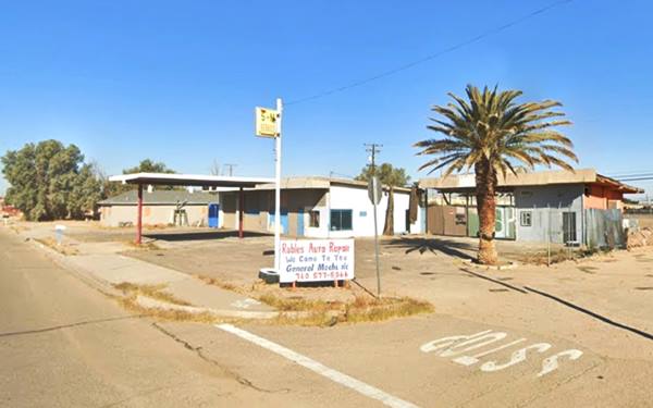
On the western side of Lenwood, at the crossroads of Route 66 and Lenwood Rd. There were several landmarks, but only one survives:
Hank's Texaco ❌
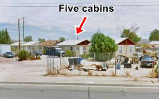
On the SW corner, gone and the cabins behind it too, were they the West Barstow Motel and Cafe mentioned by Rittenhouse? They appeared in a list of lodgings and cafes published in March 1949 in the San Bernardino Sun (1) where it mentions its owners, Christine M. and Anthony J. Muzic. It also listed the Lenwood Coffee Shop of Luise De Nise and Louise A. Hotz.
You can also see them in this 1952 aerial photograph on the SW corner of the junction of Route 66 and Lenwood Road.
Nothing remains of the property now, but until a few years ago, the five cabins and the gas station were still there as you can see in the image taken in 2012.
Do Drop Inn & Cafe
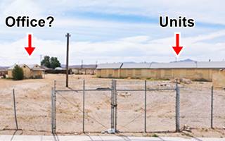
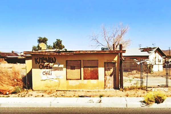
Adjacent to the Lenwood Motel, to your left, on Route 66 is the remains of the cafe facing the highway, boarded up and falling apart, and the single line of motel units behind it on the south side of the property. There is a building with a twin gable roof to the left, probably cabins or maybe the office(?)
Barlen Drive In Movie Theater ❌
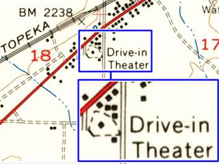
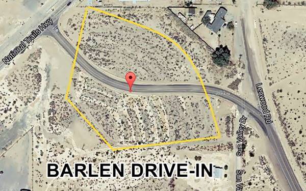
Located right beside and behind the Do Drop Inn, between Route 66, where its entrance was located, and Lenwood Ave.
The Barlen Drive-In was part of Western Amusements Group and opened in 1955. It remained open until the mid-1960s. It was dismantled and its screen is gone, but you can still make out the circular segment that the drive in theatre once occupied amd the concentric rings where the cars parked to view the movies.
Its name combined the names of the closest towns: "Bar" from Barstow and "Len" from Lenwood.
Drive-In Theaters

Barlen Drive In, 1956. Source. Click to enlarge
The Lenwood drive-in theatre was one of many during the 1950s to 70s. These were outdoor cinemas with a large movie screen and a projection booth. Some had playgrounds for children and picnic tables. There was a concession selling soft drinks and fast food. The customers viewed the films from their cars, and heard the audio by means of loudspeakers located at each parking spot. Later AM or FM radio broadcasting was used and the soundtrack was picked up by the car's radio.
Color TV, VCRs and the rise in real estate costs led to this mostly summertime business to fade away and drop its market share from a peak of 25% of the market to barely 1.5% nowadays.
The black and white image (click on it to enlarge) shows the Barlen in 1956. We mirrored it, because it was the wrong way round. The screen is to the southeast, the railroad can be seen with a train on the upper side, beyond Route 66 (1), Lenwood Rd. on the bottom (2) and the Do Drop Inn on the upper right (3)
Gullet's Market
Head west for 0.2 mi. and to your left, now marked as 3690 (27735 W Main) is the former Market from the 1950s. It began as Gullet's Market and later became Joe's Food Spot. It has been here since the 1950s. Now closed (St. view).
Whiting Bros site ❌
Ahead, 0.1 miles south, is the site of the Whiting Bros station that was torn down in the 1980s it appears in this 1952 aerial photo on the left side of the highway, at 26687 now a vacant lot as shown in this St. view (3).
The Dunes Motel
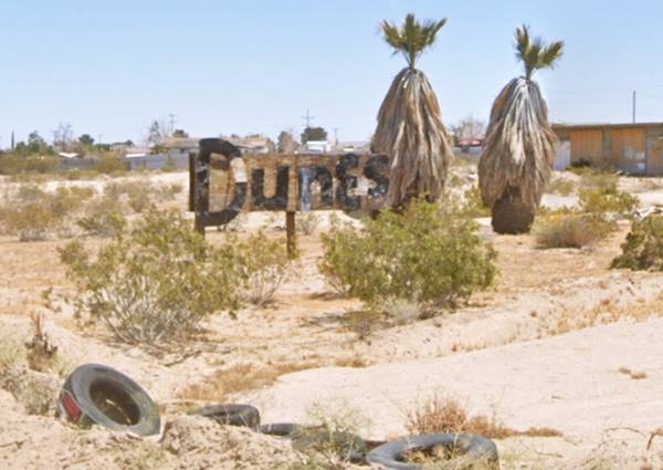
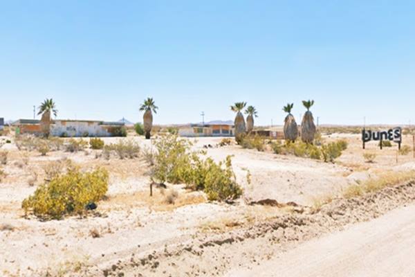
Keep west along Route 66 and after 2.5 miles, to your left are the ruins and remains of the "Dunes Motel" at 23135 National Trails Hwy. See this Map with directions.
The complex has an "oasis" style, with palm trees and the Mojave Desert as a backdrop. It probably dates back to the late 1950s as it appears in this 1959 aerial photo.
It had four separate blocks with units lined up facing the highway and a swimming pool between them and Route 66. Now it is abandoned.
Continue your Road Trip
Your journey through Lenwood ends here. Continue your "Route 66 Road Trip" by heading west towards the next stop along the highway: Hodge.
Mojave River
The river is located roughly 1.5 to 2 miles west of Lenwood. The Mojave is an itermitent river that flows in a closed basin with an area of 4,580 sq. mi. (11.862 km2), its source is in the San Bernardino Mountains at almost 3,000 ft. altitude (900 m) and it discharges into Soda Lake, in the Mojave Desert.
It is a source of water used by the desert animals and plants, and also by those crossing the Mojave since prehistoric times.
110 mi long (177 km), its discharge varies from nil to a maximum of 70,600 cu. ft. (2.0000 m3). Most of its water flow is underground as the river bed is dry most of the year.
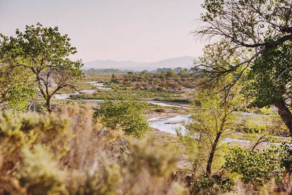
Father Garces named it Arroyo de los Mártires (Martyrs' Creek) in 1776. When Jedediah Smith followed it westwards into California in 1826 he named it "Inconstant River".
The underwater course of the Mohave River was marked by vegetation growing next to it, and therefore was in sight of Route 66 and the SF Railroad from Newberry to Victorville.

Sponsored Content
>> Book your Hotel in Victorville

Credits
Banner image: Hackberry General Store, Hackberry, Arizona by Perla Eichenblat
A Guide to the Golden State, by the Federal Writers' Project of the Works Progress Administration, Hastings House, New York, 1939.
Jack DeVere Rittenhouse, (1946). A Guide Book to Highway 66.


