The Infamous Muddy Segment of Route 66
Index to this page
About Jericho, Texas
Facts, Trivia and useful information
Elevation: 3,200 ft. (976 m). Population: n⁄a (2025).
Time zone: Central (CST): UTC minus 6 hours. Summer (DST) CDT (UTC-5).
Jericho is located in Donley County, in the eastern region of the Texas Panhandle.
History: Jericho's story
This region has been inhabited for over 10,000 years and Paleo-Indian Clovis style stone tools have been found in neighboring New Mexico.
In historic times, the Comanche and Kiowa roamed the plains hunting buffalo until they were defeated and placed in reservations after a short war in 1874 - 1875.
The Mobeetie Trail
Bison migrated south in winter and back north in spring. Their route crossed prairies where the grass grew in the fertile soil taller than a man.
Indians used these tracks to hunt bison and later white settlers moved along them, to hunt buffalo and later, to move their herds into Texas.
One of these trails linked Fort Elliott which had been founded after the war, in 1875, to control the Indians and Saint's Roost (what is nowadays Clarendon, Donley County seat) in the south. Mobeetie grew next to the fort and was the main town in the Panhandle.
Along this trail, a small mail coach stop was founded in the late 1880s. It was a place to change horses and rest: Jericho.
Like most homes of those days, it was a simple Dugout.
Dugout the home of the Pioneers
A dugout was a single room dug into a low hill. The outer walls were made of sod blocks. Holes were left for the window and door, which were covered with a canvas curtain.
Cottonwood poles covered with dry grass and topped with sods formed the roof.
Donley county was created in 1876 and organized on March 22, 1882. It was named after Stockton P. Donley (1821-1871), a Texas Supreme Court Justice.
The residents where Jericho was later platted, created a cemetery there, that received its first burial in 1895. So the cemetery predates the town and the railway station by seven years.
The railroad to Amarillo was built between 1900 and 1902, and the Choctaw, Oklahoma and Texas Railroad Company (which later was acquired by the Chicago, Rock Island and Gulf Railway) set up the station at Jericho in 1902.
Like most stations in the Panhandle it had cattle loading ramps and a water reservoir (locomotives ran on steam engines and were very thirsty).
The name Jericho
The station was named after the biblical Canaanite town, next to the Jordan and gateway to the Promised Land.
The meaning of the name Jericho is unclear and the town is mentioned in the Bible using three different names: Jer'cho, Jericho, and Jerichah, the root is the noun "reah" meaning scent or fragrance. It could also come from "yareah" which means moon as a reference to time passing (a month), from "'arah" (to travel, to wander).
Jericho boasted a post office (established in 1902) and as population slowly grew it added some stores.
US Route 66 in Jericho
The creation of the National Highway System in 1926 with the Chicago to Los Angeles highway passing through Jericho brought some prosperity: travelers began passing through the town in growing numbers. Soon it had three stores a service station, garage and even a "tourist Court" whose ruins have survived. Its local farmers shipped their grain out through the grain elevator.
Population peaked at around 100 in 1933, dwindling after that. It was a long downwards spiral: the post office closed in 1995, the tracks were abandoned and lifted in the mid 1980s, and the old buildings crumbled in disrepair. Now only crumbling walls and some concrete foundations mark site of the old vanished town. The cemetery, however, is still in use.

Movie set in Jericho Texas
The movie "Last Man Standing" (1996), directed by Walter Hill and starring Bruce Willis, Bruce Dern and William Sanderson, portrayed a Prohibition era Texas ghost town named Jericho. The bootlegging Irish and Italian mafia are faced off in a war in this godforsaken place.
Of course, the town shown in the film is much bigger than Jericho ever was.
Where to Stay in Jericho
Being a Ghost Town means that Jericho does not have any hotels.
Try hotels in the nearest big towns Shamrock, 40 miles (64 km) east of Jericho, or Amarillo, 57 miles (92 km) west.
> > Book your Hotel nearby in Amarillo or Shamrock
Find your Accommodation
The towns along Route 66 in Texas offer different lodging options. Check out some of the hotels and motels in the main towns below listed from east to west
In Texas Along Route 66
>> There is an RV campground in Alanreed and Amarillo.
How is the Weather in Jericho?
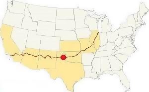
Location of Jericho TX on Route 66
The weather in the Texas Panhandle region is quite dry with an average rainfall of 23 in. (616 mm). During summer, the temperature can range, on average, between 65°F (19°C) to over 90°F (30°C).
During winters, there is snow, which usually falls during early December, but may fall at any time between early September and late May.
On average about 19” of snow fall every year, but the records show exceptional snowfall of 40 inches (43 to 102 cm).
Winter mean temperature ranges from 50°F (10°C) to 25°F (-4°C).
Tornadoes
Jericho is in the "Tornado Alley" with a higher probability of a tornado strike. Read more: Tornadoes on Route 66.
Map of Route 66 through Jericho
We divided the course of the highway across Texas into two legs, from Texola in the east to Glenrio on the NM state line. The midpoint of Route 66 is located in Adrian TX:
>> See this Interactive Map of US66 in Jericho.
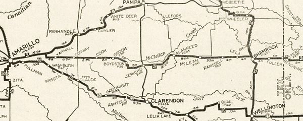
Below is a map published in 1924, two years before US 66 was created. Jericho is in the middle. The map shows the different "auto trails", dirt roads that were relatively safe and could be driven using cars.
You can follow the trail "3" from Texola to Amarillo, through Jericho. Trail #3 was the "Postal Highway, and later would become Route 66.
Route 66 Alignments
1926-36 alignment
The first alignment of Route 66 in Jericho, along the Postal Highway, more or less followed the railroad tracks until it reached the eastern side of Jericho, where it headed south, running 1⁄4 of mile further south, to avoid a series of large shallow lakes on the flat area where Jericho was located, right on the divide between the Red River to the south, and the Canadian River to the north.
Then, it zig-zagged back north, to Boydston and from there to Groom.
Click on the thumbnail maps below, to enlarge the Jericho TX (1926-36) maps
1936-1950s Route 66
The map above (click on it to enlarge) was published in 1936 (Full sized Original map), after the "Jericho Gap" was paved and Route 66 was realigned one mile to the north of Jericho.

1936 platt of Jericho
It included the platt of Jericho, which shows buildings that have vanished long ago and streets (like "Highway 18") that no longer exists, it was replaced by TX-70 that runs further east.
The map below printed in 1964 shows this same road running from TX-70 just south of I-40 & US66 (where your can read 3195 on the map), crosses the railroad where it says Jericho, and ends by the motel on what is now CR-B (second blue arrow from the right). The blue arrows mark the 1926-36 "Jericho Gap" alignment.
Interstate 40 (and the post 1936 US Hwy. 66 alignment) can be seen on the top of the map (double red line). The now defunct Chicago, Rock Island and Gulf Railway crosses the map from left to right.
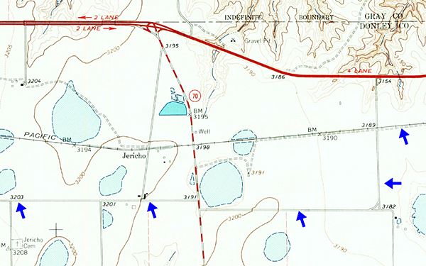
The old Jericho Cemetery is just beneath the first blue arrow on the lower left side of the map. See this Map showing how to reach Jericho from the freeway.
Route 66 Alignment near Jericho
- Amarillo to Glenrio (next)
- Texola to Amarillo (Jericho's)
- Clinton to Texola (previous)
Jericho’s Route 66 Landmarks
Things to Do and See in the ghost town: Jericho Gap
Jericho is a ghost town with a historic Cemetery along the muddy trap that once mired travelers: the Jericho Gap on Route 66.
- "Ghost Town" tour, read on below
- Tours & Itineraries
Ghost Town Attractions
The best way to reach Jericho is to leave I-40 at Exit 124, to head south along TX-70. See this map with directions, it is a 4.2 mile round trip. Part of the drive is along dirt roads.
Reed's Texaco
Eula and K.C. Reed owned a Texaco on Route 66 in Jericho, here, where the Exit is now located. It was originally built in Jericho, on the old 66 highway, but they moved it one mile north in 1941-42 to the "new" Route 66 paved in 1936.
K.C., who was born in 1883, passed away in 1948. Eula kept on running the station. She modernized it in 1956. Their son John owned a Gulf station in neighboring Groom and their other son Tom Maddox helped
her with the station in Jericho. Eula died in 1979 at the age of 87. Both Eula and K.C. are buried in the cemetery in Jericho.
The only building that we have found on the post-1936 Route 66 in Jericho, was located on the north side of the highway, at the fork where TX-70, the now vanished "Highway 18" and the four-lane Route 66 met. You can see it in this aerial photo from 1962 in the center of the image. When I-40 replaced the old 4-lane US66 and an overpass was built at the crossroads, the old gas station was torn down.
Former Jericho Depot
As you reach the first windmill that is on the left side of the highway, you will cross the railway embankment that no longer has any tracks on it. To your right you will see some abandonded buidings about 300 yards west of the highway. This is the northern side of Jericho townsite and the place where the former Jericho railway depot was located. (Map).
Jericho Cemetery Marker
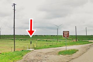
Keep on, and at the junction with CR-B, to your left is a historic marker.
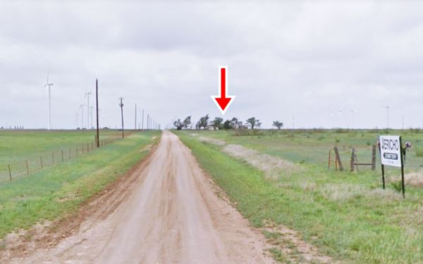
See red arrow in the image. The inscription reads "Settlement of this area of Donley County began in the late 19th century, before the town of Jericho was founded as a station on the Chicago, Rock Island and Gulf rail line about 1902. Early community burials took place in the pasture near this site, and the graveyard eventually was set aside in the county deed records. The first documented burial is that of Mattie Ray (1850-1895), and the second is that of seven-month-old Garil Prest Schaffer, who died in 1897. Others buried in the Jericho Cemetery include victims of smallpox and influenza epidemics, military veterans and area pioneers."
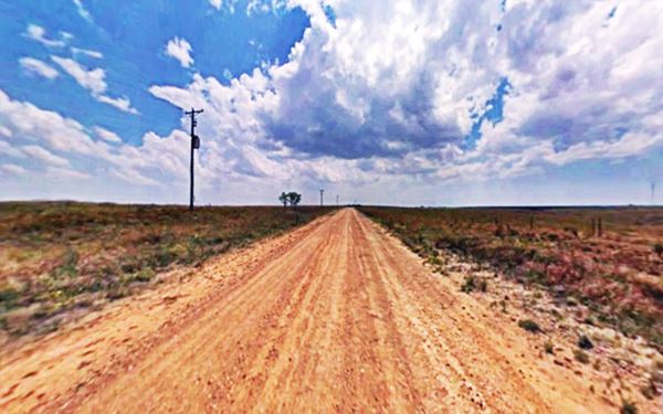
To your left is the Dirt road (pictured below); make sure it is in good conditions and that it can be driven safely (i.e. dry surface, and that it hasn't rained recently).
Ahead, among the trees, 1⁄4 mile from the paved highway, to your right is the old motel building (red arrow in image below).
Jericho Tourist Court
Drive west along CR-B. On the north side of the highway, is the old motel or "tourist court". The Texas Historical Commission survey says it was built around 1910. It consists of two separate buildings set in an L-shaped layout. The block on the north side has three rooms separated by garage areas, and the western block, facing east, has eight units with garages between them. It is in poor shape, and has a gable roof with stucco walls.
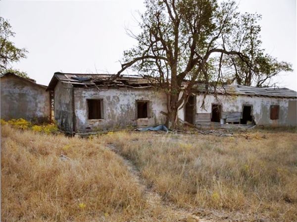

2002 view of the old house, Source
Ruins of Home and rusting car
On the western side of the motel, is the now obliterated road that with a north to south course linked it to the railway depot before modern TX-70 was built and paved.
Following it, is a one-story rectangular shaped building with stucco walls and a hip-roof that collapsed. It was a home, though the Texas Historical Commission survey suggests that it was possibly the office of the motel.
There is a rusty hulk of a car next to it, a 1948 Ford coupe.
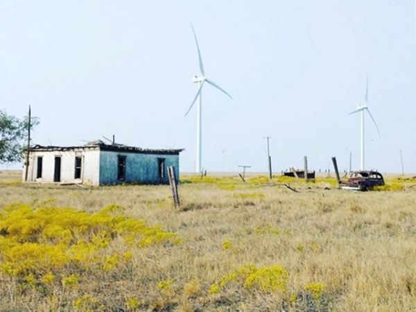
On the south side of the road, facing the motel complex are the ruins of more buildings. You can see the motel, these buildings and the road that linked them to Jericho's railway depot and US66 further north, in this 1962 aerial photograph.
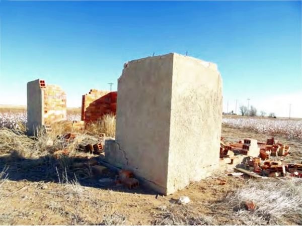
Drive west along CR B for 0.7 mi, and take a left at CR 10, just ahead, to your left is the old cemetery.
Jericho Cemetery
An austere cemetery in a field. Burials still take place here.
The road west of the Cemetery is mostly located in private property, and has not been maintained. There are two concrete culverts built in 1925 on this old alignment.

Jericho, concrete culvert, Source
Concrete Culverts
You can spot both culverts in this map, it shows the solitary stretch of the original "mud" surfaced road west of Jericho, and at the two tips of the itinerary you will see the two ancient concrete culverts (zoom in for a better view).
The eastern culvert is actually a small bridge, with concrete railings and angled abutments. See image below.
Historic Route 66 in Jericho
The Jericho Gap
Jericho, TX.
The national highway system implemented in 1926 was slowly but steadily paved. By the early 1930s, most of the Texan alignment of U.S. Highway 66 was paved except for one short stretch, the infamous Jericho Gap which was a dirt surfaced road.
This gap ran from a point 6.2 miles west of Alanreed, Rockledge Station, and the town of Groom.
When the weather was dry the dirt surfaced Route 66 was fine but when it rained the unpaved road turned into a sticky mud and the cars got stuck in the mire.
Farmers used chains to brave the goo, but tourists were not so well prepared and had to resort to the locals for help when their cars got bogged down in the Black Gumbo.
The cars had to be pulled out of the mud with horse teams, and this was a good source of revenue for the local farmers.
Black Gumbo
Black Gumbo is the local term that describes Texan soil: it is named after a Texan meat or seafood stew with vegetables that is thickened with okra pods or filé.
The rich, black fine-grained clay soil of the Panhandle was fertile and grew whatever was planted on it. When the weather was dry it looked like chunks of charcoal, but... when wet it became a sticky heavy waxy goo.
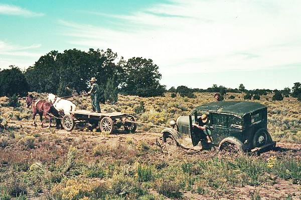
The soapy mud would become impervious and stick to anything, bogging down cars with its weight.
Texas Mud and the invention of the disk plow
Eight Norwegian families migrated to Texas in 1854. One of them were the Ringness. Jens Ringness' son Ole had some nasty experiences with the Texan black gumbo as a mail carrier between Clifton and Fort Worth.
He noticed that the cart wheels threw out mud to the side and he had the idea that a plow using a saucer shaped blade would be ideal for the soggy wet black topsoil of Texas.
He fashioned a prototype in Jen's blacksmith's shop and went to New York City to patent his invention. He died shortly after the patent was approved, but since his family did not pay the patenting fee the patent was never issued.
A paved Route 66 to bypass Jericho Gap
The Route 66 Association, local businessmen and residents lobbied with the state government in Austin to pave the gap. An article published in Oct. 1932 in the Shamrock Texan give us an idea of how problematic the Gap was: "JERICHO GAP MUST BE PAVED, U.S. 66 DELEGATES DECIDE - (the) unimproved gap there is giving the entire routa a "black eye" and that its impassable condition in rainy weather is causing thousands of tourists to avoid the Panhandle... (with) 16 miles, the only unpaved stretch on the road between Amarillo and Oklahoma City. ...The road had not been paved because right-of-way had not been furnished... One land owner near Jericho, by his refusal to give or sell the land is now holding up the road... the only route agreeable to the state was on the north side of the railroad."
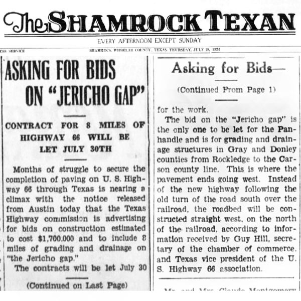
But it took time to get it paved. Another article published on July 19, 1934 it mentions that bids were open for the paving of the Gap, from Rockledge, where the paving ended (east of Jericho) to Carson County line (next to Groom). It again says the road will be built on the north side of the railroad (bypassing Jericho).
Finally, on Oct. 9, 1936 (read article) was the great day that the paved segment was inaugurated. Visitors from three states came to McLean and a holiday was declared to honor the event.
The new paved road finally bypassed the Jericho Gap and the roadway had been moved half a mile north of the town to higher ground and a straigher alignment.
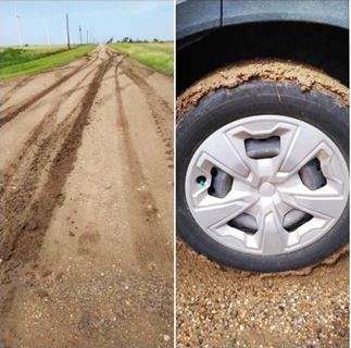
Mud at Jericho Gap, July 2021, Source
Precautions: Driving the Old Route 66
The Jericho Gap section is marked with a Black line in our Jericho Gap Map.
Some parts of it cannot be driven (private property, or missing roadbed) so you will have to bypass them.
On its western part, the old road goes by another ghost town, Boydston before reaching Groom.
Bear in mind that this is a solitary dirt surfaced road. Take care and check with the locals if it is in good shape for driving (it may have rained recently and this will be an issue). See the images taken by Mr. Nolan in July 2021. The tire is plastered with sticky mud!
Sponsored Content

>> Book your Hotel in Amarillo Texas

Credits
Banner image: Hackberry General Store, Hackberry, Arizona by Perla Eichenblat
Jack DeVere Rittenhouse, (1946). A Guide Book to Highway 66.
Gloria B. Mayfield, 2002. Jericho Cemetery, Donley Co. Cemeteries of Texas
H. Allen Anderson, "Jericho, TX", and "Boydston, TX". Handbook of Texas Online, Texas State Historical Assn. Publ.
Ringness House Museum
Texas Historical Commission (2002), US Highway 66 survey and Jericho Historic survey.
Jericho On 66


