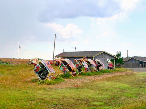
VW beetles buried nose down in the ground!
Bug Ranch, Graffiti covered Beetles nose down in the ground, Conway Texas
Index to this page
About Conway, Texas
Facts, Trivia and useful information
Elevation: 3,460 ft. (1,055 m). Population: est. 10 (2025).
Time zone: Central (CST): UTC minus 6 hours. Summer (DST) CDT (UTC-5).
Conway is located in the south of Carson County, in the central region of the Texas Panhandle.
There are Two Conway's on Route 66
This one in Texas and another in southern Missouri: Conway MO
Conway's History
The Panhandle region was peopled by hunter-gatherers over 10,000 years ago. Their Clovis stone tools have been found in nearby New Mexico, and belong to some of the first humans to reach America.
Until the Spanish introduced Old World horses to America, the local Comanche and Kiowa Indians hunted buffalo and deer on foot. Later they learned to ride and were masters of the plains until well after the independence of Texas and its annexation by the U.S.
Between 1874 and 1875 a war raged between the natives and the U.S. Army which led to the defeat of the Indians and their confinement in reservations. The grasslands were opened to the pioneers.
The first County in the region was Bexar (1876), from which Carson County with seat in Panhandle (8 mi. north of Conway) was organized in 1888 and named after Texas Secretary of State Samuel P. Carson
The first building to go up in what would become Conway was a Lone Star School, built in 1892 for the children of homesteaders and ranchers. It was followed by a post office (1903) and the Chicago, Rock Island and Gulf Railway (also 1903).
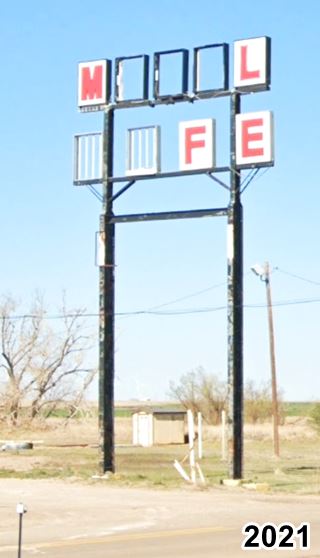
The motel and café sign in Conway as time goes by. Click for St. views
In 1905, J. D. Delzell and P. H. Fisher founded the town which they named Conway, after H. B. Conway, who had been a Carson County commissioner.
A church was built in 1912 and the community slowly grew, its economy rooted in cattle and farming.
When U.S. highway 66 was established in 1926, its alignment passed through Conway and the town's population grew from 25 in 1925 to 125 in 1939 (despite the Depression and the Dust Bowl years).
Population grew until the late 1960s, and then began to fall. The post office closed in 1976 and the railway terminated its operations in 1980. I-40 bypassed the town and business moved out. Current population is estimated at around 20.
Getting To Conway
Conway is the first town to the west of Groom (16.5 mi away) along I-40. Take Exit 96 and go south along TX 207 for 1 mile to reach Conway.
It is 69 mi (111 km) west of the Texas - Oklahoma state line.
Heading west from Conway, it is 29 miles (47 km) to Amarillo and 96 miles (154 km) to the New Mexico state line. To the east it is 68 mi (109 km) to Shamrock.

Where to Stay in Conway
The closest motel is in Claude, just 6 miles south of Conway along TX-207: Claude, TX.
Try hotels in the nearest big towns: Shamrock, 66 miles or Amarillo, 28 mi west.
>> Book your Hotels in Amarillo
Find your Accommodation
The towns along Route 66 in Texas offer different lodging options. Check out some of the hotels and motels in the main towns below listed from east to west
In Texas Along Route 66
>> There are RV campgrounds in Amarillo.
What is the Weather in Conway?
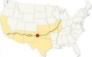
Location of Conway on Route 66
With an average rainfall of 23 in. (600 mm); the Panhandle is a dry region. Summer is hot, with average highs over 90°F (30°C) and average lows of 65°F (19°C).
During winter high temperatures average 50°F (10°C) with below-freezing lows below: 25°F (-4°C).
Snow does fall in Conway and this can happen at any time between September and May (although the first flakes fall on the first week of December). The high altitude causes greater snowfall than locations further to the east: 18” per year on average (with peaks of over 40”) between 43 and 102 cm.
Tornadoes, this is Tornado Alley, read more: Tornadoes on Route 66.
Map of Route 66 in Conway, TX
See this map with the alignment of US66 in Conway
Route 66 itinerary across Texas
We divided the course of the highway across Texas into two legs, from Texola in the east to Glenrio on the NM state line. The midpoint of Route 66 is located in Adrian TX:
Below is a map published in 1924 (two years before US 66 was created, it shows the "auto trails" that were roads that could be driven by cars). You can follow the trail "3" from Texola to Amarillo, Conway is on the left side of the map. Trail #3 was the "Postal Highway", "50" entering Amarillo from the South was the "Ozark Trail" it ran from Oklahoma City west, south of what would become Route 66.
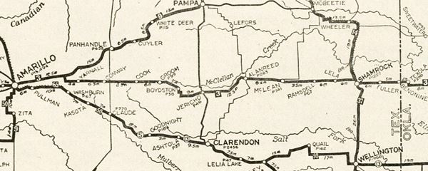
You can always check out our Route 66 Map of Texas, with the complete alignment and all the towns, including Conway.
Map with the alignment of Route 66 through Conway
See this map of US 66 alignment in Conway
Route 66 Alignment near Conway
- Amarillo to Glenrio (next)
- Texola to Amarillo (Conway's)
- Clinton to Texola (previous)
Conway’s Route 66 Landmarks
The classic sights in town!
Historic Context
Rittenhouse published his Route 66 guidbook after driving the whole of US66 in 1946, He describes Conway as follows:
...Gas; small garage; cafe; store; one small court; limited faclities. No gas station for the next 25 miles! Jack Rittenhouse (1946)
We will tour the town from east to west starting at the point where I-40 curves to the north away from the South Frontage Road (Route 66). This is where the original four-lane alignment built of Route 66 became a 2-lane road through Conway. The map below shows the four lanes (the eastbound ones are now the S. Frontage Rd., the westbound ones are now buried under I-40's eastbound lanes). Notice how in 1960, the curve that bypasses Conway hadn't yet been built.
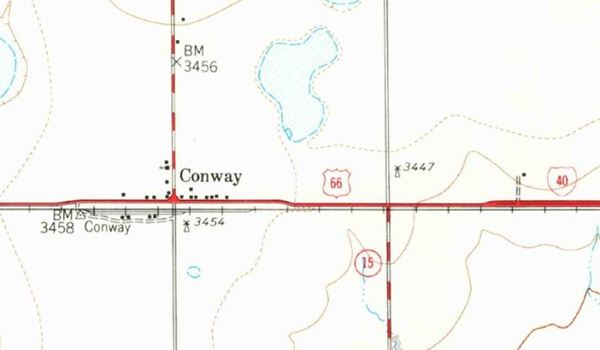
It is a 1.6 mi. drive west to the crossroads of US 66 and State Highway 207 that comes from Claude, to the south. There are a few scattered homes along US66. This is Conway. The corridor where the railway once ran is on the south side of the highway. The tracks have been removed.
Site of old Motor Court and Buddy's Gas station
Just 250 yards east of the crossroads are the foundations of the now razed motel, the motor court mentioned by Rittenhouse, and an old gas station from the 1930s.
You can see what they looked like in 2009 before being torn down, and the same spot in 2021 after they were demolished. Route 66 buildings slowly fade away.
Turn right along TX-207 and just ahead, to your left is the old school.
Conway School
The school was built in 1930, it is a large single story brick building, with a plaque next to the entrance with the name of the board of trustees and the date (1930). In the old photo below you can make out the words "Conway School Dist 8" above it. Below is a "Then and Now" set of pictures.
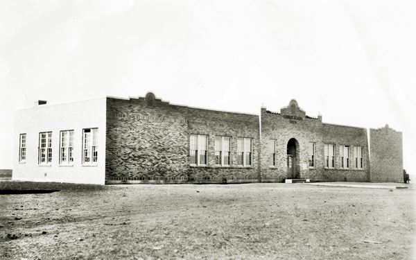
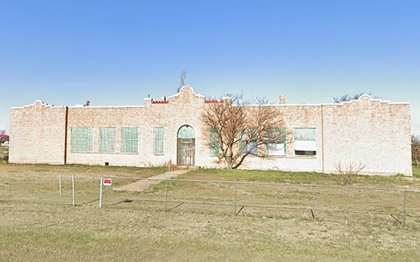
Continue north till you reach the S. Frontage Rd. and turn left, there is a Motel here at the intersection dating back to 1970.
Next to the motel is the "Bug Ranch".
Buggy Ranch or Bug Ranch

Bug Ranch April 2021
At I-40's Exit 96 on the South frontage road before (map with location).
This attraction is free of charge and is known as the Bug Farm, Slug Bug Ranch, Buggy Ranch, and Bug Ranch.
Since 1967 the Crutchfields have operated a service station and souvenir shop on the south frontage road of I-40 at its crossing with TX 207 in Conway.
But business took a turn for the worse in 2002, when a Love's Travel Stop (a truck stop) opened on the other side of I-40: most of the potential customers went there.
So the Crutchfields decided to create an attraction on the south side of the Interstate and found inspiration in the Cadillac Ranch (west of Amarillo): they parodied it by burying five Volkswagen Beetles (Bugs) nose down in the ground.
Visitors came but business did not improve and the Crutchfields moved on. The visitors can paint the cars with spray graffiti just like they do at the Cadillac Ranch.
Buggy Ranch or Bug Ranch, Conway
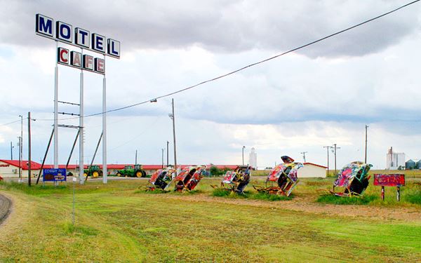
Chuck Coker
Click image for a 2021 St. view.
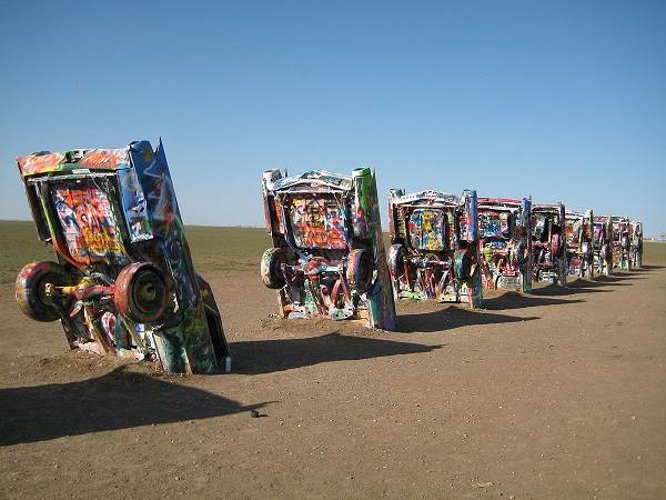
Cadillac Ranch
Below is a view of the Cadillac Ranch parodied by the Bug Ranch:
View of the "Caddy Ranch" or Cadillac Ranch with its Cadillacs buried nose down in the ground
Two other "cars buried nose down on Route 66" sites
There are two other places on Route 66 with cars buried like the VW bugs in Conway (or the Cadillacs at Amarillo):
(1) Henry’s Rabbit Ranch, in Staunton Illinois on the 1930-1940 alignment of US66, and (2) OK County 66 - John's Place in Arcadia, Oklahoma

Buried Beetle, at John's Place, Arcadia Oklahoma, Source

Rabbit Ranch, Staunton Illinois
Abandoned Crutchfield gas station
Next door is the old abandoned "Longhorn Trading Post" store and the derelict gas station (Route 66 Budget Fuel), now in ruins.
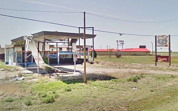
West along the South Frontage Road is another motel (from 1965), and the signs pictured at the top of this page. Turn around and retrace your steps; head back to Historic Route 66 at its junction with TX-207.
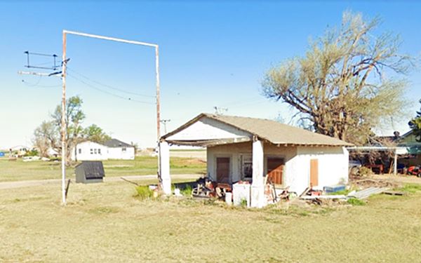
Walker's Gas Station
On the NW corner of Route 66 and TX-207 is this craftsman style gas station built in 1949. It has a small gabled roof building and the roof extends as a canopy over the pump island, located between two box pillars that support the roof. In poor shape. Owned by Cecil and Zelma Walker, it closed in 1966. There was a cafe next to it (to the left) but it has been torn down.
Enco Humble Station
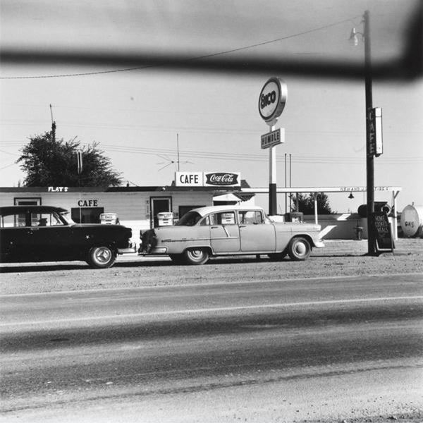
American artist Edward Ruscha lived in Los Angeles and drove frequently along Route 66 (he was captivated by it). His artwork "Enco - Conway, Texas" from his work "Five Views from the Panhandle" Series was taken by Ruscha in 1962 and printed in 2007.
The image shows an Enco Humble gas station with two 1950s cars (the car on the right side looks like a 1955 Chevrolet Bel Air), and a cafe.
We haven't been able to find any information about this station, but below is the photograph, which has historic value.
To the south of Route 66 you can see the grain elevators built in 1958.
This is the end of your city tour in Conway
Tours & Itineraries

Historic segment of Route 66, Conway, TX. Credits

Old Route 66 sign in Conway. TX
Historic segment of US Highway 66
Listed in the National Register of Historic Places
Texas FM 2161 (Historic Route 66) from TX207 to Exit 89 of I-40, Conway TX.
The seven mile portion of Texas Farm to Market Road 2161 between Conway (TX 207) in the east and I-40's exit 89 was listed in the National Register of Historic Places in 2007.
This segment of US Highway 66 was chosen for protection because it is the best preserved and also one of the longest sections of untouched US Highway 66 in the State of Texas.
This is a Map of the historic US66 Segment.
Driving along this two lane road is like traveling back in time: it is the open range of the Texas Panhandle. Windmills pumping fresh water for the cattle, farmland dotted with the occasional windmill, grasslands and a few dirt county roads intersecting Route 66.
This is exactly the scenery that greeted travelers of the 1930s, 40s, 50s and 60s: dirt roads, farms and fences enclosing the prairie.
Peace Farm
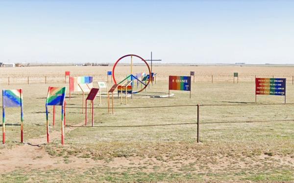
On the north frontage road of I-40, west of Exit 87 (FM 2372), 10 mi from Conway just after the rest area (map with directions).
The "Peace Farm" or the patriot Peace Garden is shaped like the CND sign 200 ft. in diameter (60 m). The CND symbol was an anti-nuclear logo created during the 1950s British campaign for nuclear disarmament. It combines the flag-signals (used in the navy) for letters N and D (initials of Nuclear Disarmament). It became very popular during the 1960s and 70s.
The monument consists on many metal objects, signs and markers with peace proclaiming texts cut into them. It is the work of a local farmer, Richard D. Baker. It has benches and the dates that wars ended, signs such as "Give peace a Chance". From space you can make out the shape of the CND Peace sign logo (see image).
East along US 66
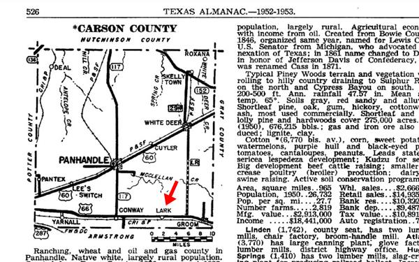
To the east of Conway just before Groom, is what once was a small hamlet: "Lark".
Lark
A Ghost Town
7 miles east of Conway along I-40. At the bridge over I-40 of CR V (south) and Farm to Market 2880 (north), see map.
Located in the south or Carson County. The Chicago, Rock Island and Gulf Railway built a siding here in 1903 and named it after Lark Stangler, who was a local rancher
A post office opened in 1909, but moved to Conway six years later. Population reached 10 in 1915 which grew to 20 in 1940.
It had a school, church and a store. The post office reopened in 1925 but was closed for good in 1957. People moved out, the railway ceased operations in 1980 and in 1984 its population was 26. Lark was not included in the 2010 Census.
Today a grain elevator marks the spot.
Sponsored Content

>> Book your Hotel in Amarillo Texas

Credits
Banner image: Hackberry General Store, Hackberry, Arizona by Perla Eichenblat
Jack DeVere Rittenhouse, (1946). A Guide Book to Highway 66.
H. Allen Anderson, "Conway, TX" Uploaded on June 12, 2010 and "Lark, TX". Uploaded on June 15, 2010. Handbook of Texas Online, Published by the Texas State Historical Association.
Route 66, SH 207 to Interstate 40, Conway, Texas National Park Service.


