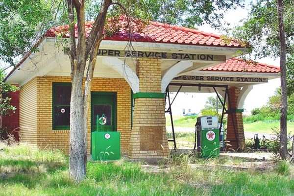
Alanreed with its Super Service Texaco station
Index to this page
About Alanreed, Texas
Facts, Trivia and useful information
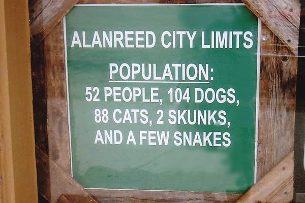
Elevation: 2,993 ft. (912 m). Population: 33 (2025).
Time zone: Central (CST): UTC minus 6 hours. Summer (DST) CDT (UTC-5).
Alanreed is located in Gray County, in the eastern region of the Texas Panhandle.
Alanreed's History
Paleo-Indian hunter gatherers lived in the Texas Panhandle 10,000 years ago. The Spanish explorers seeking for the gold of the mythical «Eldorado» met their descent, the buffalo hunting Comanche and Kiowa Indians. After some skirmishes and a war in the late 1870s, the Battle of McClellan Creek took place on November 8, 1874 a few miles north of what would later become Alanreed.
Texas Panhandle
The Texas Panhandle covers a rectangular section of northern Texas. New Mexico borders it to the west and Oklahoma to the east.
Most of it is flat (High Plains), and it is quite a dry area which averages about 20 inches of rain annually (500 mm); however the Ogallala Aquifer supplies water for irrigation of the loamy, clayey, and calcareous soils of the plains.
The Indians were defeated and placed in reservations; the plains became available for settlement: by 1884, the Clarendon Land and Cattle Company was already selling lots of land in what would become Alanreed.
Alanreed's original name was Springtank or Springtown because it had a large water tank fed by a spring. It was also known as Prairie Dog Town because of the great amount of those animals in the area.
In 1886 a post office opened in Eldridge, a stage-coach stand a few miles north of what is now Alanreed. At that time the population of Gray was 58 inhabitants.
The Texola to Amarillo line of the Chicago, Rock Island and Northern Gulf Railway reached Alanreed in 1902. The town had been laid out by its engineers a year before. It was located on the crossing with the stage line from Mobeetie to Clarendon.
Alanreed. The town's Name
There are several versions: one states that it was named after two managers of the railroad, Alan and Reed. Another says that it was the name of a contractor Alan & Reed. And yet another says that it was the name of a Negro employee of the railroad. What is a fact is that the 1902 County elections were held in the home of an Allen Reed. Some early 1900s publications mention it as two words "Alan Reed".
Eldridge post office moved to Alanreed in April 1902. In those days Alanreed was the largest town in the area and when Gray County was organized in 1902, it lost the county seat to Pampa by only two votes.
At that time it shipped 500 boxcars per year, filled with fruit, mostly watermelon, to the east.
The oil boom in the mid-1920s led to the development of Pampa, Lefors and McLean but Alanreed did not benefit from it although its population peaked to 500 in 1927. The Dustbowl and Great Depression led to its decline.
The Postal highway linking Oklahoma City and Amarillo was Alanreed's Main Street and that led to U.S. Route 66 passing through the town.
During the 1930s and 40s, service stations and hotels were built along 3rd St., because the town was the last stop before the dreadful stretch of road crossing the Jericho Gap.
But after the mid-1950s, a slow downward spiral began, and when the last segment of I-40 was completed in August 1982, one mile east of the town, it sealed its fate. At that time the Rock Island abandoned its railroad but the post office still survives to this day.
Getting To Alanreed
Alanreed is the fourth town along I-40 and U.S. Route 66 after entering Texas from Oklahoma. It is 42 miles (68 km) west of the Texas - Oklahoma state line.
Heading west from Alanreed, it is 74 miles (119 km) to Amarillo and 136 miles (219 km) to the New Mexico state line. McLean is 8 miles (13 km) to the east.

Where to Stay in Alanreed
There is a motel next to the post office shown above, by the freeway. The closest town with a pick of places to stay is neighboring Shamrock, 27 miles (43 km) east of Alanreed.
>> Book your Hotel in Shamrock
Find your Accommodation
The towns along Route 66 in Texas offer different lodging options. Check out some of the hotels and motels in the main towns below listed from east to west
In Texas Along Route 66
>> There is an RV campground in Alanreed.
The Weather in Alanreed
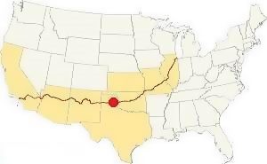
Location of Alanreed TX on Route 66
The Panhandle area is relatively dry with a rainfall that averages 24 inches (618 mm) per year. The summers are quite hot (from June through September) with average high temperatures that exceed 90°F (30°C) and mean low temperatures of around 65°F (19°C).
The winter temperatures range from highs that average 50°F (10°C) and lows whose average are below freezing: 25°F (-4°C).
Snow: In this region it can snow during Fall and even Spring (from September to May), and the first snow usually falls during the first week of December). The high altitude causes greater snowfall than locations further east: 17” per year on average (with peaks of about 40”) - 43 to 102 cm.
Tornados
The Texas Panhandle and Alanreed lie within the "Tornado Alley", so there is a chance of tornado strikes in the area. You can read more here: Tornadoes on Route 66.
Map of Route 66 in Alanreed TX
1926-32 alignment
Heading West from McLean to Alanreed the original 1926-32 alignment, was a dirt road, unpaved. It ran south along FM Rd 2695 and then west south of the railroad (more or less where BB Rd. is nowadays), it entered Alanreed along its Main St. with a south to north alignment (map) then it turned west along 3rd Ave.
Paved 1932-35 alignment
Then it was paved and shortened, so the 1932-36 Route 66 ran in a course close the now lifted railroad tracks -which can't be driven nowadays (Map), and then took a straight course into Alanreed which it followed until the 1950s when it was straightened a bit more. See the The 1932-50s alignment map, along the frontage road of the freeway, and across the town along 3rd Ave.
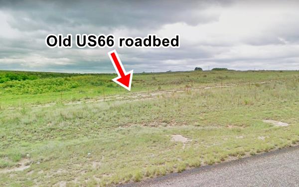
You can see some of the 1930s original paving, now abandoned, to the south of the S. Frontage Rd. (red arrow in image below, and see this satellite image where it describes a curve).
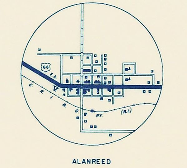
Below is a map of Route 66 crossing Alanreed along 3rd Ave in 1936.
1950s alignment
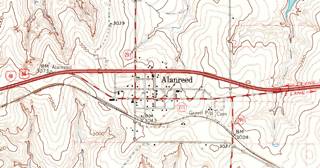
The 1963 USGS map (click thumbnail to see a larger map) shows the four-lane alingment, which still had grade crossings (no overpasses). This was much later upgraded into the modern freeway (I-40).
The 1950-70s alignment before the freeway was built, was a four-lane highway along 6th Avenue.
Check out Alanreed on our Route 66 Map of Texas, with the complete alignment and all the towns along it.
Route 66 began as a dirt road, but by the late 1930s had been paved. By 1956, Route 66 was already improved and had been upgraded to a four-lane divided highway all the way to Jericho, and the final part near Amarillo.
Route 66 Alignment near Alanreed
- Amarillo to Glenrio (next)
- Texola to Amarillo (Alanreed's)
- Clinton to Texola (previous)
Texas Road Safety
Keep updated and check the Road Information online: TxDOT Highway Conditions
Exit and entry ramps of I-40 do not intersect its service roads, they merge with them. Remember that those driving the on- and off-ramps have the right of way. All drivers along the I-40 Frontage Roads must yield to ramp to avoid collisions with those exiting I-40.
Alanreed’s Route 66 Landmarks
Jack Rittenhouse, in his 1946 "Guidebook to U.S. Highway 66", drove through Alanreed, and mentioned it.
ALANREED. ( Pop. 1,489; alt. 2,993'; Ranch House court; gas; cafes; few stores... Rittenhouse (1946)
The classic sights in town!
- Route 66 tour in Alanreed, read below
- Tours & Itineraries
Town Attractions
Alanreed is a small "almost ghost town" on the south side of I-40. There are some scattered homes along the mostly empty streets.
We will tour it from east to west, starting at the intersection of highways 291 and 271 (where the South Frontage Rd. enters the town). Ahead, to your right is the Cemetery.
Alanreed Cemetery
On the southwest corner of the crossing of TX-291 and TX-271. Half a mile east of Main St.
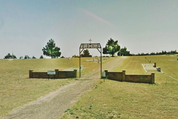
Historic Route 66 Marker: The Oldest Cemetery in Texas along Route 66.
Despite that the sign on the left side of the gate that says that the first internment took place in 1890, the cemetery association claims that the first burial was that of Nancy Baker, wife of Rev. W. H. Baker, in 1899.
It holds around 550 graves; among them is that of Roy Tipton, "murdered in cold blood" in May 1916.
Unnamed Motel
Head west along Route 66 it is a semi-rural setting. On the NE corner of 2nd St. and Route 66 (3rd Ave.) to your right is an old Motel.
The 2002 Highway 66 survey of Alanreed (see Sources) describes this "L-shaped" building as a Motel. It has a cross gable wood-shingle roof, stucco walls and a chimney. Apparently built in 1935.
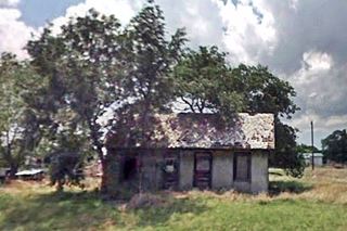
In an abandoned and neglected state, and quite small too.

Abandoned motel, Alanreed TX. Source
Click for St. view
Tourist Cabin
Facing the motel half way down the block, on the western side of Second street is a steep pitched gable roof building, which the 2002 Survey identified as follows: "looks to be a 2-room tourist cabin cleared lot suggests may have been 2nd cabin." Pictured above.
Old Filling Station
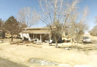
On the NW corner of Route 66 (3rd Ave and 2nd St) you will see a long one story building, currently a home, but it used to be a filling station. The author of the 2002 survey, Monica Penick noted it was a "service station converted into home (per owner who I met on street)... no evidence of function remains"
On the next corner of the same block, to your right, on the NE corner with E 1st St. is an old cafe and gas station.
Magnolia Mobil Café and station
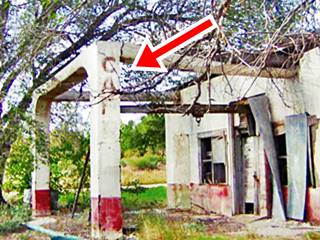
Built in 1935 it has a box shaped layout, with several windows facing Route 66 and a canopy -now roofless- held up by two strong colums with curved corners a style favored by Mobil in the 1930s.
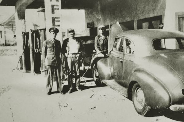
The photo below was taken probably during WWII (man in US army uniform) and shows a Chevrolet Deluxe parked under the canopy.
The word "Cafe" above the serviceman, can still be seen on the column (marked with red arrow in the photo).
Early 1940s picture of Magnolia Cafe and Mobil Station
Just ahead is the best known Route 66 landmark in Alanreed, the Texaco Super Service.
66 Super Service Station
SW corner of Main and 3rd Streets. This is where the original 1926-36 alignment of Route 66 reached Alanreed from the south, and turned west. Later Route 66 was realigned to run only along 3rd St.
This restored vintage service station was set on the busiest corner in what was downtown Alanreed. It was built in 1930 for Bradley Kiser.
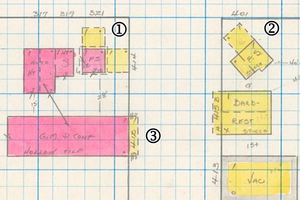
The image below is a hand drawn plan of Alanreed (click on the link in the caption to see the full size print). It shows 3rd St running left to right, and Main St. top to bottom. On the upper left corner (1) is the 66 Super Station marked with the letters "FS" for "Filling Station", it has its two canopies in yellow and the adjacent garage to the left. On the opposite side of the street is another filling station (2), long gone, and (3) next to the Texaco is the Merit Feed & Seed red-brick building.
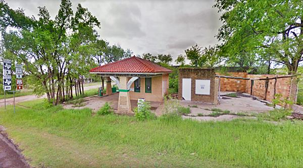
The building has two separate canopies, one facing north towards 3rd Avenue, the other east, towards Main Street. Each is supported by a central column. The building has a low Spanish style tile ceramic hip-roof. Its style combines Craftsman with Spanish Eclectic
It now has Texaco ® pumps, but we have not been able to verify the brand it sold back in the 1930s and 40s.
The corner has a set of road signs signal the point where routes TX-271 and TX-291 which come from the east, split, with TX-291 turning north up Main St. towards I-40, and I-271 keeping straight, together with the "Old Route 66" brown and white shield, both heading west.
The image below shows the gas station facing 3rd, the signs on the left side and the remains of the two-bay service garages on the right side.
Next to the service station, on its southern side, along Main Street is the former "Merit Feed & Seed store", built around 1930, it has a mural on its northern brick facade with the word "Merit" written inside a yellow diamond, on top of a pale blue square with a red checkered background (St. view).
Merit Mills Inc., incorporated in 1926 and was judicially dissolved in 1952. It produced animal feed and sold it in Oklahoma and Texas.
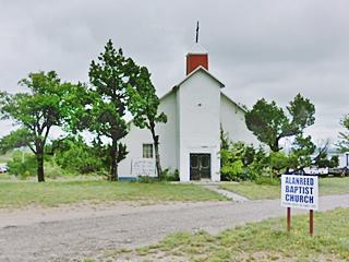
First Baptist Church
Historic Route 66 Marker: Oldest church on Texas Route 66
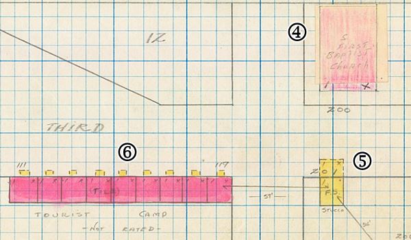
Head west, on the corner with Church St. and W 2nd St, Route 66 curves towards the NW. Here, to your right is the historic church. We marked it with (4) in the 1933 Insurance map below.
This austere white building nestled between pine trees was built in 1904 and claims to be the oldest church along Route 66 in Texas.
Old Tourist Court
To your left, at one time stood a gas station, marked (5) in the plan below and next to it a nine-room Tourist Court. Maybe the "Ranch House Court" mentioned by Rittenhouse? Now it has gone and left no traces.
You can see it in the 1933 insurance map below, (6).
Motel, Café Post Office and Jail
Drive on, passing the RV campground towards the freeway. To your right is a gas station and the Café, Post Office and Motel complex.
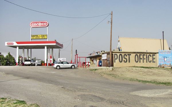

Windi Inn Motel, Alanreed. Source
The café and post office dates back to 1967. It is a Ranch-style A-frame building. The motel next to it was built in 1965. And at one time was known as the "Standish Courts" with a Cafe and Conoco gas station. As you can see in this 1962 aerial photograph, there were no buildings here, next to the old four-lane Route 66 & I-40 back in 1962.
Later it became the "Windi Inn" (see postcard) and since then has lost the office located on its western tip (St. view), but has retained its low, long layout and gable roof.
Don't miss the "Jail" on the western (right - St. view) side of the cafe it is a great tourist attraction.

The "Jail" in Alanreed, Source

Snakepit Sulpture, Source
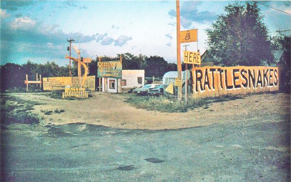
Regal Reptile Ranch - Snake Pit
Now head east along the South Frontage Rd (6th Ave.) to the site of a famous "snake pit".
Adie Alred andher brother E. Mike Alred operated snake pits along Route 66 in Oklahoma (different sources say Elk City, others Sayre), and one here in Alanreed. The brother-sister partnership didn't work, so Mike moved to a location close to Lela (read more about Rattlesnakes Galore).
Adie kept on running this snake pit until her death. Its postcard below says it featured "the famed but tamed killer rattlesnakes."
It shows a larger than life sized snake (the curved yellow object to the left of the building), which can still be seen in the Devil's Rope Museum and Route 66 Museum in McLean. It is pictured above in a phot by Steve Fitch taken in 1972 in Sayre Oklahoma.
Nothing remains of the old snake ranch, it was located on the SE corner of Route 66 (S. Frontage Rd. and E 2nd St. see the St. view).
This marks the end of your Alanreed City Tour.
Tours & Itineraries

Bruce's petrified wood home. Source
Petrified Wood Home
Just 6.5 mi north of Alanreed (map, it is on Private Property, don't trespass) is a house built in 1925 by a tree nurseryman called Paul Bruce. He bought the property in 1925 and used petrified wood gathered from the remains of an ancient prehistoric forest south of Alanreed.
The home has a castle-like appearance and eight rooms. In 1974 Burl Stubbs bought the house, and named it "Hidden Valley Ranch", on McCellan Creek.
Burl and his wife Pat sold it in 2012 and moved to Amarillo.
Texan towns (Glen Rose, Austin, Huntville, and Stephenville among others) employed petrified wood as a decorative building material in the late 1920s. The fad spread to Oklahoma and Louisiana, but originated in Texas.
Sponsored Content

>> Book your Hotel in Amarillo Texas

Credits
Banner image: Hackberry General Store, Hackberry, Arizona by Perla Eichenblat
Jack DeVere Rittenhouse, (1946). A Guide Book to Highway 66.
Alanreed Cemetery, www.cemeteries-of.-tx.com
Texas Historical Commission, 2002 Highway 66 survey of Alanreed
H. Allen Anderson, "Alanreed, TX", Handbook of Texas Online. Texas State Historical Association.


