Home to one of the tallest crosses in the world
Index to this page
About Groom, Texas
Groom: Facts, Trivia and useful information
Elevation: 3,255 ft. (992 m). Population: 545 (2025).
Time zone: Central (CST): UTC minus 6 hours. Summer (DST) CDT (UTC-5).
Groom is located in the south of Carson County, in the central region of the Texas Panhandle.
Groom's History
The Panhandle region has been inhabited for over 10,000 years, their historic period descent were the Kiowa and Comanche Indians who hunted buffalo.
Following Texas' Independence and annexation by the U.S., White settlers entered the Panhandle. After a war with the Indians in the mid 1870s, they occupied the territory vacated by the natives, who were enclosed in reservations.
At that time, the county was founded (1876) and named for Samuel Price Carson, the first secretary of state of the Republic of Texas.
The open range drew the attention of Charles G. Francklyn, an Englishman, who formed a syndicate in 1881 to invest in livestock in Texas. The Francklyn Land and Cattle Company initially bought 631,000 acres of land in the Panhandle region of Texas and Oklahoma.
The company hired colonel B. B. Groom, a Kentucky cattle breeder and relative of Francklyn as its American manager.
Groom improved the local longhorns by importing polled Angus from Scotland and Shorthorns from Kentucky. He had wells drilled and invested in sheds, living quarters, barns, corrals and miles of barbed wire.
But the tough winter of 1886 and the high level of expenses led to the company's bankruptcy shortly after, followed by its reorganization as the White Deer Lands Trust. The new company brought in settlers and sold land to them and this led to the founding of farming communities like Groom and LeFors.
It was W. S. Wilkerson, a local landowner, who founded the town of Groom in 1902, naming it after the colonel.
The name: Groom
Groom is an English family name which designated the person responsible for the feeding and taking care of horses. Etymology: from grom(e), Middle English for boy or servant. In East Anglia: servant or shepherd.
That same year, the Chicago, Rock Island and Gulf Railway laid down the station and Frank S. Dysart opened the first post-office in town. Soon there was a Bank, hotel, school and more stores.
Agriculture and ranching plus an oil boom in the mid 1920s grew steadily. Route 66 was created in 1926 and its alignment passed through Groom.
White Deer concluded its business successfully and was liquidated in 1957. Population peaked at 808 in 1972 and then slowly decreased.

Hotels in Groom
The closest motel is in Claude, just 15 miles south of Conway along TX-207: Claude, TX.
Try hotels in the nearest big towns: Shamrock, 52 miles or Amarillo, 45 mi west.
>> Book your Hotels in Amarillo
Find your Accommodation
The towns along Route 66 in Texas offer different lodging options. Check out some of the hotels and motels in the main towns below listed from east to west
In Texas Along Route 66
>> There are RV campgrounds in Amarillo.
The Weather in Groom
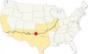
Location of Groom on Route 66
The weather in Groom is semi-arid weather and has large variations between daytime and nighttime temperatures. The highs during summer average around 108°F (42°C) while the low temperatures are on average about 90°F (32°C). The high altitude of this part of Texas moderates the summer temperatures. Also, the nights are cooler, about 25°F cooler than the daytime (14°). The average high temperatures during Winter are about 52°F (11°C) with lows of around 25°F (-4°C).
Rainfall is scarce and adds up to some 20 inches (500 mm), most of it falling during summer. Sunny weather is very common and it helps moderate the winter daily temperatures. The Texas Panhandle area is very windy.
Snow. Sonw does fall in Groom. You can encounter snowfall between September and May. The first snow often falls during early December. On average the area gets 17” with peaks of about 40” (43 to 102 cm) per year.
Tornadoes, Groom is within the Tornado Alley. You can read more about Tornadoes on Route 66.
Map of Route 66 in Groom
See this map with the alignment of US66 in Groom
Route 66 itinerary across Texas
We divided the course of the highway across Texas into two legs, from Texola in the east to Glenrio on the NM state line. The midpoint of Route 66 is located in Adrian TX:
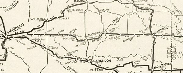
The following map published in 1924 shows the "Auto Trails" in northern Texas. This was just two years before the creation of Route 66 in 1926. Auto trails were roads that were in fairly good shape and could be driven by cars. Trail "3" runs rom Texola to Amarillo, Groom is just left of the center of the map. Trail #3 was a "Postal Highway". Trail "50" was the "Ozark Trail" and it ran from Oklahoma City westwards to the south of what would later become Route 66.

USGS Map (1960) of Groom
Route 66 was originally a two lane highway, and by the 1960 it had been widened and became a four-lane highway and designated as I-40 as well as being US 66. The map shows the 1960 USGS map of Groom, with US-66 & I-40 running along Front St. on the south side of the town. Nowadays I-40 arches around its northern side. The original interstate despite having four lanes didn't have the standards it has nowadays (i.e. it ran through the city with grade crossings).
This is a map of Route 66 through Groom.
You can always check out our Route 66 Map of Texas, with the complete alignment and all the towns, including Groom.
Route 66 Alignment near Groom
- Amarillo to Glenrio (next)
- Texola to Amarillo (Groom's)
- Clinton to Texola (previous)
Groom’s Route 66 Landmarks
The classic sights in town!
- Groom City Tour (read below)
- Tours & Itineraries
Groom: the town's attractions
Driving along Historic U.S. 66 (Front St.) you will see several abandoned service stations and a motel. Nostalgia and the quiet simple ways of bygone days are still alive in Groom. Park on its Main Street, Broadway. and take a stroll along it.
We begin our tour on the eastern side of the city, coming from Jericho, and we will cross it from east to west along Route 66. As you approach Groom along Route 66 - North Frontage Rd., you will spot a leaning water tower to your right.
Leaning Water Tower
I-40 north Frontage Road, 0.2 mi east of Exit 114, Groom, TX. See its St. view.
Americana and Route 66 wacky attraction
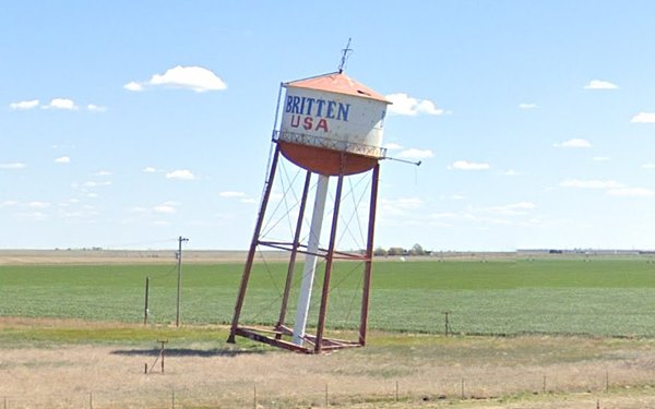
It is a steel water tower that is tilted in such a way that it seems to be ready to topple over!
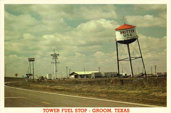
The Tower Fuel Stop postcard above reads "Look for the leaning water tower! What holds it up? No cables or concrete support..."
This eye catching water tower is located on the north side of I-40 and old U.S. Route 66. It seems as if it would topple over but it won't because it was deliberately placed there in a tilted position by the owner of a now long-gone truck stop, Ralph Britten (whose name figures on the tank that tops the tower).
Ralph Britten bought the tower structure in Lefors, 40 miles to the northeast of Groom and mounted it at his truck stop burying one side deep into the soil at a sharp angle, with the other side's legs clear of the ground, in the air.
As an engineer he knew the physics of stability: if the tower's center of gravity remained within the base of support it would stay put no matter what.
As the tank was empty, there was no extra water mass on the top of the tower that would have displaced the center of gravity beyond the base. See the explanation below.

High center of gravity (tank holds water)

Low center of gravity (empty tank)
Physics of a stable object: as long as the object's center of gravity remains within the base of support, the object will not topple over, but if it goes beyond the Tipping Point, it will fall. The center of gravity is the average location of the weight of an object. In the first figure as the tank holds water, the center of gravity is higher, and this means that a smaller displacement can make it move beyond the base and topple.
An empty tank means the center of gravity is lower, giving the tower more stability: it would have to tilt further to make it fall beyond its base.
Ralph C. Britten (1923 - 2000). Born in Groom, he worked on the family's farm and fought in World War II, in the US Air Force, receiving a Flying Cross.
As an Army Air Corps engineer he had the know-how to put up the leaning water tower next to the Tower Fuel Stop that he owned and operated.
It drew attention and a steady flow of customers to his Tower Fuel Stop which was closed for good after a fire.
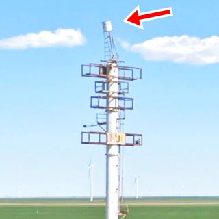
Just east of I-40s Exit 114 underpass you can still see the Tower Fuel Stop's sign with a "mini leaning tower" mounted on its tip (red arrow in picture).
At the Exit, turn left, and head south to meet the continuation of the original Route 66 alignment and head west, into Groom.
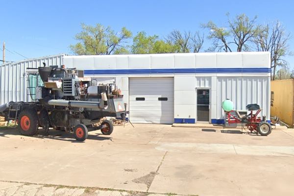
Gulf gas station
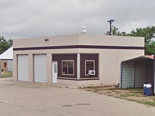
At 501 Rte 66 on the NW corner of Shelton Ave. This is a classic 1953 Gulf gas station in very good shape. It has the styel adopted by Gulf from 1937 to 1960, with Streamline Moderne style, such as simple lines, rounded corners and edges, white porcelain enamel panels on its walls and blue porcelain enamel panels along the base. Three blue bands run across the upper part of the building. And it has two service bays.
No canopy or pumps. It probably was Reed's Gulf, as he owned one in town, and it is the only one advertised in the local newspaper.
Golden Spread Motel
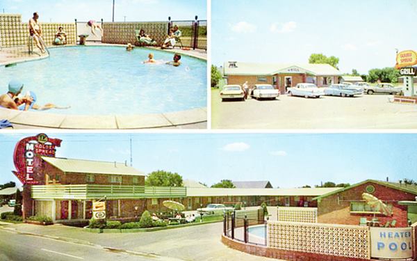
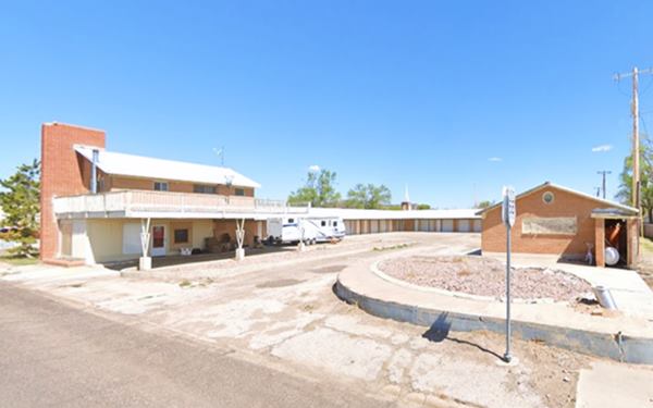
On the same block, to your right (511 Front St.) is the Golden Spread Motel, build in 1955. Its 1960 postcard pictured below tells us that it had "22 new units, individually refrigerated air conditioned, sound proofe, excellent food... T.V. in rooms."
Now it is a mini-storage and the pool (lower right side of the image) has been filled in with gravel, but the balcony over the office is still there.
The name "Golden Spread" was coined by ah Amarillo journalist, Wesley "Bob" Izzard in the early 1950s to promote the Texas Panhandle-Plains area, it highlights the black gold (oil) and the golden wheat.
Golden Spread Grill
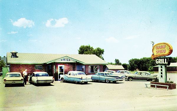
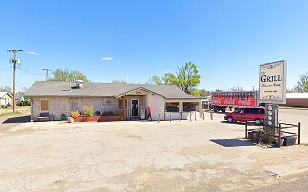
The motel is followed by the Golden Spread Grill, whose postcard proclaimed "Stop at the Golden Spread to be among the Best Fed", Mrs. Ruby Denton was the hostess. The building is still standing and is "The Grill", at 407 Front St. Notice that the base of the neon sign with "holes" has managed to survive.
Next door is Pav's Tire Service, it opened back in 1950 and has (St. view) changed considerably so you can't make out what gas brand it sold at that time.
Homer Mobil gas station
On the next block you will see two vintage gas stations from the 1950s. The first one, at 301 Front St. has had different names over the years, it was originally Homer's Mobil gas station. It is an oblong box station with two service bays and an office. It opened in 1953. Later it was Groom Car Wash and Britten Truck Sales.
We have seen this station mentioned as Homer's Magnolia station built in 1955 after US66 was widened, which later became a Mobil. However this advert published in 1955 announces the grand opening of Al Homer's Texaco at this same address.
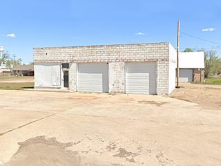
Next door at 307 Front St. is another old gas station built with blocks, two bays, office facing west. Abandoned, this one dates back to 1952 according to the Texas Historic Resources Survey Inventory, but the brand is unknown. It is pictured above.
Groom gas stations advertised in the local newspaper (The Groom News) check it out, it has many adverts and local news in this August 25, 1955 issue from where we took the following images.

Texaco advert in Groom's paper 1955.

Pool's Skelly ad in Groom's paper 1955.
On the same block, but facing Wilkerson St. was the "State Motel", with a U-shaped layout on its NW corner with W 1st St., it was torn down years ago.
Blackwell Chevron
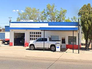
Dating back to 1949, it has a vintage pump under its flat canopy. Painted red, white and blue, with two multiwindow service bays, this old Chevron station is located on the NW corner of Choctaw and Front St.
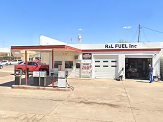
R & L Fuel
On the next corner, at Broadway and Front St., is R&L Fuel. It opened in 1949 It has a single pump island under its flat canopy. The canopy has a flat fin-like projection on its upper side, with a rounded tip, here went the brand name. It has two service bays, and is decorated with three sets of paralel ridges running across the upper part of the building and the canopy.
Turn right along Broadway to see the historic markers on the town's main street.
Historic Marker: City of Groom
On 203 Broadway, at the library (St. view).
Marker #: 5065000886, Year Dedicated: 1968. It has a summary of the town's history: "Founded 1902 by W.S. Wilkerson, local landowner, when Rock Island Railroad built west; named for Col. B.B. Groom, 1880's agent of Francklyn Land & Cattle Co. Col. Groom was first to try power farming on Plains. Town is today hub of rich farming and ranching area. (1968)."
Historic Marker: Bank
At the State National Bank on 114 Main Street.
Marker #5101, erected in 1972 (St. view). It tells about this private bank founded in 1904 and chartered state-wide in 1908. Among its directors were members of the local pioneers, the Brittens (of tilted-water-tower fame). The bank survived several crises, the Great Depression and 1930s Dust Bowl as well as both World Wars. To this day it supports its Groom customers in the oil and agribusiness.
Dr. Fields Historical Marker
On the wall of the City Hall (St. view). Marker #1264 dated 1966, remembering Dr. Charles L. Fields (1858 - 1941), a local dentist and farmer. He worked as a carpenter to pay his way through dental school and settled in the region in 1903. He'd visit his patients at the ranches carrying his collapsible dental chair and foot-powered drill.
Site of 66 Courts Motel (gone)
Return to Front St. and turn right. On the next corner (NW at Route 66 and Texas Ave.) once stood the 66 Courts Motel & Magnolia Station. Both razed. Compare the image with current St. view.

The 66 Courts already abandoned in the 1980s
Former Fina filling station
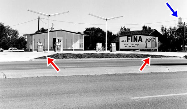
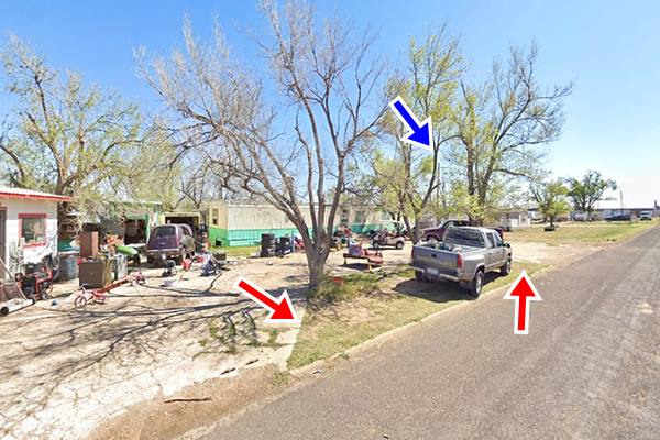
Ahead is the former Fina station photographed in 1962 by American artist Edward Joseph Ruscha. It is part of his Five Views from the Panhandle Series.
The place has changed considerably, the clean gable roofed office and the pumps have gone. Now trees grow on the patch of grass in the trapezoid-shaped patch of grass in front of the station, with its concrete curbs (red arrows). The concrete parking apron is there, cluttered, and the site has the appearance of a trailer park. Groom's water tank (blue arrow) is in the same place and helped us locate the site.
Chris Britton Restaurant
At 602 Front St. is a former "Chris Britton" restaurant that opened in 1950 (to your right), now "Britten Cattle", a gabled roof buiding with canted plate glass windows (St. view).

Thumbnail Whiting Station. See original image
Whiting Bros Service Station
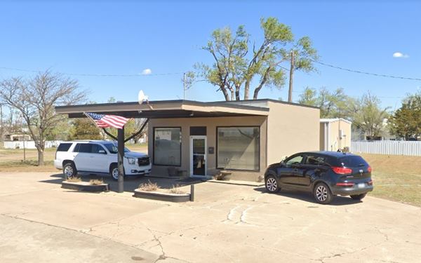
606 Front Street. Located on the north side of Route 66 this WB station is still standing, and has been repurposed as the offices of the Justice of Peace.
The building retains its canopy and concrete pump island
Headquartered in Holbrook, the company built built over 100 filling stations plus fifteen motels and truck stops in the Southwest, between Texas and California.
Many of thems were located along Route 66. Their slogan was "Most of the Best for the Least".
The company went through difficult times during the Arab Oil Embargo in 1973, and gradually sold off their stations and motels.
Present appearance of the former Whiting Bros. Gas Station Groom Texas
> > Learn more about Whiting Bros. stations on Route 66
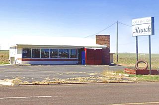
Ranch Cafe
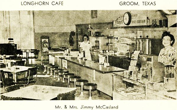
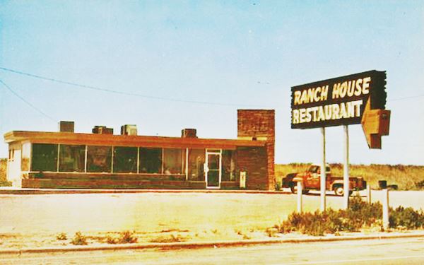
Ahead, to your left, on the south side of the highway is the former "Ranch House Cafe", later the Blessed Mary and Mary Restaurant.
It opened in 1950, and according to their postcard,
served the "Best Coffee in Texas Open 24 Hours". Joe Sonderman in his "Route 66 in Texas" wrote that "it was owned by Jimmie and Mammie McCasland".
Surprisingly, the "Longhorn Cafe" was also owned by the McCaslands... could Ranch and Longhorn cafes be one and the same?
West's Phillips 66

Webb Phillips 66 advert in Groom's paper 1955.
At 707 W Front St., the last building on the south side of the highway, to your left. This used to be Jack and Bettye West's Truck Stop.
Jack West's obituary tells us he was born in Arkansas in 1926, met Bettye Johnston in McLean and married her in 1952. They moved to Groom where, in 1963 they bought the Groom Truck Terminal, and ran it until they retired in 1983. Both were inducted into the Route 66 Hall of Fame in 1992. Jack passed away in 2016.
It is possible that until 1963, this was Carl Webb's Phillips 66 station.
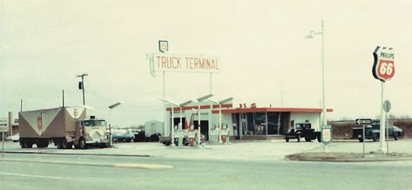
The gas station is a typical Rock Frame Phillips station from the 1950s.
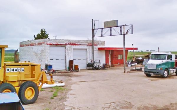
Site of LA Motel
Across the street, facing the gas station once stood the L.A. Motel, torn down in 2020. This was the location for the 1992 movie "Leap of Faith" starring Steve Martin, Debra Winger, and Liam Neeson. It was modified (a second floor added to the office) and renamed "Our Place Motel".
See this view of the motel that looked very similar to the Golden Spread with a balcony on the second floor!
Turn right along Western St. to visit the "Giant Cross" (map), only 0.8 miles away.
Giant Cross
Cross of our Lord Jesus Christ Ministries
Cross Ministries, 2880 County Road 2.
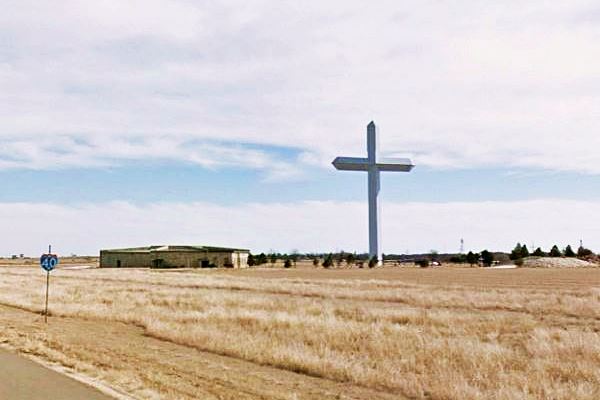
One of the tallest crosses in the World, 190 ft. (58 m) tall.

Groom Cross. Source
This gigantic cross is just west of downtown groom (see map above) and can be spotted from 20 miles away.
The basic steel structure of the cross was welded at a site located 40 miles from Groom and taken to the site where siding was attached to the structure.
The reinforced concrete foundations were poured and the different parts were assembled. And a crane was brought to the spot on seven flatbed trucks.
The cross' lower section was mounted on the foundations and the middle section was joined to it using 300 lb. (150 kg) steel pins.
At the base of the cross, around it, encircling it are several life-sized bronze statues with scenes of Christ being judged, carrying his cross, the last supper and the crucifixion with two thieves.
The site has rest rooms and a Cross Gift Shop as well as a Counseling Center and a stone crypt with angels.
Size
The cross is 190 feet tall (58 m), roughly the height of a 20 story building.
The cross weighs 2.5 million pounds (1.13 million metric tons) and has been designed to resist the very strong Panhandle winds (140 mph)
Other Large Crosses
Below are the heights of the tallest cross in the world, and the tallest crosses in the US.
- With 492 ft (150 m), the concrete cross at the Valle de los Caídos - Valley of the Fallen (a Spanish Civil War memorial) built in 1958 is the tallest. It weighs 440 million pounds.
- The Mission Nombre de Dios Cross (Name of God) in Saint Augustine, Florida, finished in 1966 weighs 70 tons and is 208 ft. tall (63 m). It is built in stainless steel.
- The tallest cross in America is located in Effingham, Illinois and is 196.8 feet tall (60 m).
Tours & Itineraries
Lark, a Ghost Town
1.7 miles west of Groom along I-40, at the bridge over I-40 of CR V (south) and Farm to Market 2880 (north). Here are the remains of what once was a small town (Read more about Lark in our Conway page).
Jericho Gap
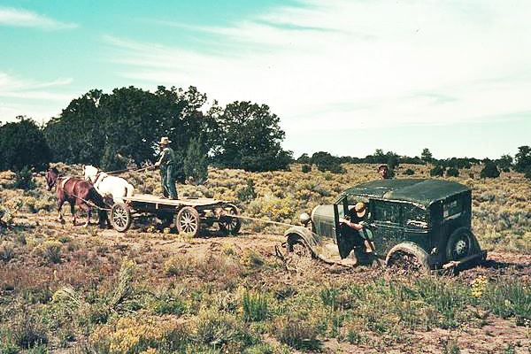
To the East is the infamous «Jericho Gap», a sector of the 1930s highway that was unpaved and became a quagmire when wet.
Boydston
Ghost Town
The site of a vanished town. East along I-40, 5.8 mi. This ghost town is on the Jericho Gap at CR 5 and I-40.
Set close to the Donely county line it was first settled by Henry Sanford Boydston, hence its name. A post office opened in 1891 but later moved away. The Chicago, Rock Island and Gulf Railway built a siding here in 1903, and it served the small farming community in the area.
Population reached 40 between 1940 and 1964 when the new I-40 sealed its fate; people moved out. The railway shut down in 1980 and the place became a ghost town.
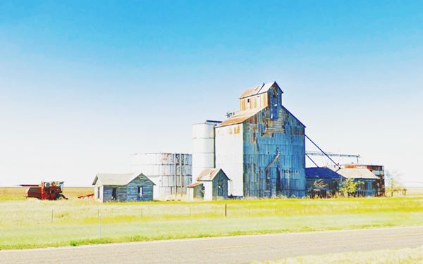
Today an abandoned grain elevator marks the spot.
Sponsored Content

>> Book your Hotel in Amarillo Texas

Credits
Banner image: Hackberry General Store, Hackberry, Arizona by Perla Eichenblat
Jack DeVere Rittenhouse, (1946). A Guide Book to Highway 66.
World's Largest Crosses - Effingham Illinois
H. Allen Anderson, Francklyn Land and Cattle Company Uploaded on June 12, 2010 and "Groom, TX". Uploaded on June 15, 2010. Handbook of Texas Online, Published by the Texas State Historical Association.
Cross of our Lord Jesus Christ Ministries
Wade, Max & Wade, Helen. The Groom News (Groom, Tex.), Vol. 30, No. 26, Ed. 1 Thursday, August 25, 1955, newspaper, August 25, 1955; Groom, Texas. Accessed September 7, 2021. University of North Texas Libraries, The Portal to Texas History, https://texashistory.unt.edu; crediting Carson County Library.


