Tours close to Kingman in Western Arizona
Visit neighboring Chloride, a ghost town
Index to our Kingman pages
On this Page
On Page #1
Tours close to Kigman
White Cliffs Wagon Road
Historic Site

Ruts in White Cliffs wagon trail. Source
0.9 mi. north of the Visitor Center at the old powerhouse. Map and directions.
You can park at the trailhead and walk along the trail. Free; no admission fee charged. Total length of trail 650 ft.
At the White Cliffs Wagon Trail Park you can hike along a trail to visit a section of the old wagon road used to bring ore from the mines to the railway depot at Kingman
The heavy carts that used it from 1870 to 1900 wore deep ruts in the soft volcanic rock, which you can see during your hike. (The red arrows in the image mark the deep ruts).
The trail was bypassed in 1912 and the original cart road with its deep ruts is still there.
Camp Beale Springs
Historic marker

Marker at Camp Beale Springs. Source
Just 1.8 miles to the west of town, Map, directions.
Beale Expedition
In 1857, the U.S. government commissioned Lt. Edward "Ned" Fitzgerald Beale on a mission to survey and open a wagon trail from Fort Smith in Arkansas to California. His route is roughly aligned with the one followed later by Route 66, and was known as the "Beale Wagon Road". It became the main route used by settlers moving into California until the railway was built in the mid-1880s.
Beale used camels imported from Tunis as pack animals. Though hardier than mules, the camels scared both horses and mules. The Army decided not to use camels in the future.
You can still see another part of Beale's Wagon Road close to Route 66, north of what is now Parks, AZ.
The Springs
Although known to the local natives for thousands of years, it was "discovered" by Edward Fitzgerald Beale. It was a good water source in a dry area and it became a stop on the Prescott to Hardyville toll road in the 1860s.
However, war soon broke out with the Hualapai natives due to the increased presence of white people in their land. This led to the Hualapai War of 1866 to 1870.
The defeated natives were confined in a reservation at the springs in 1873, but moved to La Paz the following year. The camp closed in 1874.
The Hualapai were allowed to return to their territories, later they were relocated to another reservation at Peach Springs, AZ, on Route 66).
The springs were used as the source of water for the newly established town of Kingman. A small reservoir was built there. It is a nice spot to trek in the wild or have a picnic. There is a marker and its inscription reads:
This camp, established March 25, 1871, by Company F, 12th Infantry, commanded by Capt. Thomas Bryne, was located at a spring used by Indians for centuries. It was named for Navy Lt. Edward F Beale, who established a wagon road along the 35th parallel.
In 1865, William Hardy created a stop on his toll road from Prescott to Hardyville. It was an Army outpost during the Hualapai War of 1866-1870.
The location became a temporary reservation for Hualapai Indians from 1871 to 1874. The spring later supported mining, agriculture, and domestic water needs for the town of Kingman.
Ha' Qa' Muwe marker
There is a second marker (on the stone). Its inscription reads:
Ha' Qa' Muwe (Ancestral Home of the Hualapai)
In Memory of Our Hualapai Ancestors
Who Fought Against Cultural Genocide With Bravery and Foresight
They Sacrificed Their Lives So The Hualapai People's Survival May Continue Today And Forever...
This location was a temporary Internment Camp for the Hualapai People until the Infamous Forced March Of The La Paz Trail Of Tears, April 21, 1874
This ends your tours close to the city of Kingman. Now head out for some longer itineraries in your car.
Hotels: Where to Stay in Kingman
Lodging & accommodation in Kingman!
>> Book your Hotel in Kingman
More Lodging Near Kingman along Route 66
Find more lodging & accommodation close to Kingman; there are plenty of lodging options in the cities and towns along Route 66; click on the links below to find your accommodation in these towns:
Eastwards
In Arizona Along Route 66
Westwards
You are so close to Las Vegas and the Grand Canyon!
Visit Santa Claus and Chloride
A short trip (54 mi. round trip) along US 93 to the NW of Kingman. See this Map and directions.
U.S. Highway 93 - New I-11
To Hoover Dam and Las Vegas

Hoover Dam, Lake Mead, and I-11 bridge
US Highway 93 links Kingman with Las Vegas, Nevada, and just 14.4 miles from Kingman you will reach Santa Claus, Arizona.
There was a dirt road that linked Kingman with Chloride, which was extended to the site of Hoover Dam and designated as state road 69 in 1934. After the completion of the dam in 1935, traffic could cross the Colorado River along the top of the dam. SR 69 became US 93 between Kingman and the dam, and US 93 in Nevada was extended from its southern terminus in Glendale, through Las Vegas to Hoover dam
Currently there is a large-scale construction project building an exchange between US-93 and I-40 in Kingman, so there will be detours and delays until its completion in 2027 (more at AZDOT). The highway is being upgraded between Boulder City and Kingman to become the new Interstate 11.
It became the main highway for those visiting Hoover dam.
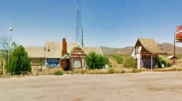
Santa Claus Arizona ❌
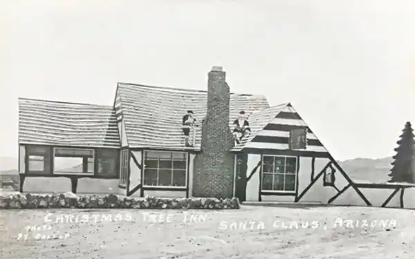
The site was razed back in 2021. The old abandoned buildings surrounded by desert shrubs are gone. But, at one time, it was part of an ambitious Christmas-themed project. The postcard below, postmarked in 1972, reads on its back:
Christmas Tree Inn, Open Every Day. Breakfast and Luncheon-Dinners on Sunday
Gift Shop Open - Overnight Camping
Weekday Dinners by Reservation
Gene and Helen Cole
Homemade Bread, Pies, Cakes Real Home Cooking
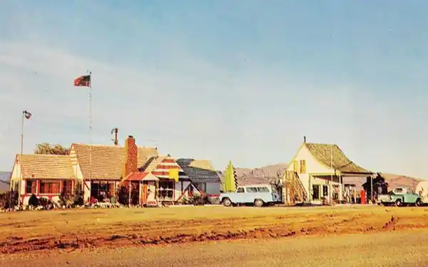
The gas station is on the right, the inn on the left. On the far right is the "Third Little Piggy House" and part of the roof of "Cinderella's Doll House."
Below is a view of it in 2021, before it was torn down.
The History of Santa Claus AZ
A realtor from Los Angeles, Nina Talbot, purchased 80 acres in the Arizona desert in 1937, with the intention of developing it around the Santa Claus-Christmas theme.
She built the Christmas Tree Inn the following year and ran it with her husband. Its purpose was to attract buyers who would invest in a property in the "town".
It was a hit among the tourists traveling along Hoover Dam highway and became a well known restaurant. It also had a Texaco gas station.
But the only buildings in Santa Claus were the inn, a gift shop, a small one-room house, and its only residents were the Talbots and the Post Office employees.
Nobody invested in the new real estate development.

Third Little Piggy House. Source

Cinderella's Doll House. Source
Christmas Tree Inn
The media reported that its walls were decorated with fairyland characters and its menu specialties were salads and pastries.
Its big hit was Kris Kringle rum pie and many tourists stopped by to savour it.
The Talbots sold out in 1949 and the new owners developed it along the Christmas theme, adding Cinderella's Dolls House, a wishing well, the House of the Third Little Pig (fittingly built with bricks), and a small train.
The Post Office was very busy during Christmas, Thousands of letters were postmarked at Santa Claus and mailed to children across the country.
It later slipped down a slope of decline, and was eventually boarded up.
Below is the Christmas Tree Inn at Santa Claus Arizona 1940s. Notice the two Santas on the gabled roof next to the chimney.
Return to the highway and head west to Choloride.
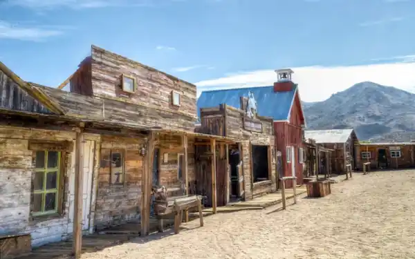
Chloride "Ghost Town"
27 mi. to the NW of Kingman
Though not technically a ghost town, as it has 393 residents, it has its "Ghost Town" section that you can visit.
It was established in the early 1860s as a mining camp when silver chloride (hence the name "chloride") was discovered in the mountains. The ore also had lead,
gold, zinc, copper, and vanadium.
A wagon route and stage coach linked it to Beale Springs (the main road passed through there), and later, a branch line was laid by the railroad from Kingman, which operated until 1935. It was the county seat from 1877 to 1887 and reached 5,000 inhabitants.
Mining came to an end after World War II. The old town is almost an "Old West" ghost town with many original buildings: the bank, jail, station, and post office.
You can also visit the "Roy Purcell Murals" painted on the canyon faces in the Cerbat Mountains. There are tours to take you there (rough roads).

Chloride Fun Facts & Trivia
- Chloride is the oldest continuously inhabited mining town in Arizona.
- The post office opened in 1873 and is the oldest still-working post office in Arizona (see the historic building on the town's main street).
- There are reenactments of gunfights on some weekends each month.
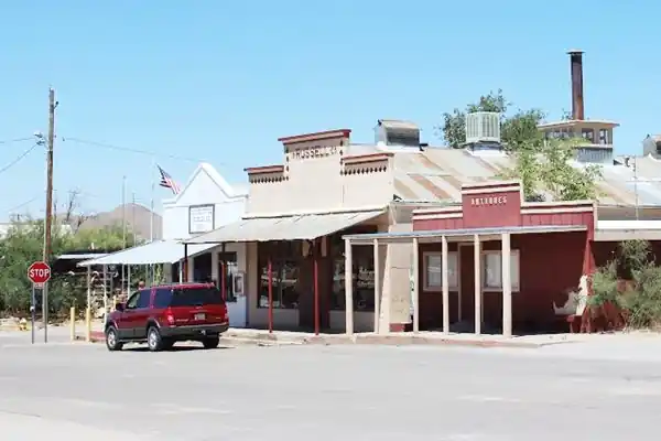
The Post Office is the building on the left.
What Next?
You can return to Kingman or drive further afield heading north to Hoover Dam and Las Vegas.
You can also visit the Colorado River and Laughling in Nevada.
Resorts on the Colorado River: Laughlin Nevada
Lauglin is a resort town only 34 miles west along AZ-68 (Map with directions).
Laughlin began as a small town known as South Pointe. It was frequented by those who fished in the Colorado River.
In 1964 Don Laughlin visited the area and bought the land to develop it as a tourist attraction. He built a motel and a small casino. The town boomed and was named after him.
It is a "Little Vegas" with resorts, shows, casinos, and gaming.
Those who like nature and being in the open can enjoy golf, hiking, and outdoor activities in the water on the Colorado River (fishing, kayaking, boating, and jet skiing).
You can take a short detour to visit it, and return to Route 66 via Kingman or Needles.
You can find a hotel and book your room here:
>> Book your Hotel in Laughlin, Nevada
Side Trip to Lake Havasu City

Lake Havasu City, the lake, and the London Bridge. Source
It is 61 miles south of Kingman. See this Map with directions
The resort town of Lake Havasu City on Lake Havasu (a reservoir on the Colorado River), has beaches along the lake's scenic shoreline, an active nightlife, and the original London Bridge, brought here all the way from London, England!
Visit the state park (entrance fee required) where you can hike and enjoy the outdoors by the riverside.
Visit the scenic shoreline with beautiful beaches, nature trails, boat ramps, and many convenient campsites.
>> Find your Hotel in Lake Havasu City, Arizona
Learn more about the outdoor sites in the Havasu State Park official website.
Western side of Kingman along the Old US Hwy 66
The original 1940s alignment that existed before the freeway was built in 1979 ran to the east of the freeway's alignment to McConnico. Take it westbound. See the map below.
>> See the violet line in our custom Map of Route 66 across Kingman.
After the Powerhouse, the original alignment curved south, crossing a gully. Here, to the left are some original sites along Route 66.
One is a small building, now an attorney's legal services office, with a great triangular crest projecting over the roof. The other, a cabinet factory has, partly visible, a brick building with a chimney-like block over a ranch-styled roof, possibly a former Shell gas station.
Drive west along the original 1940s to 70s alignment of Route 66
Whiting Bros. Station
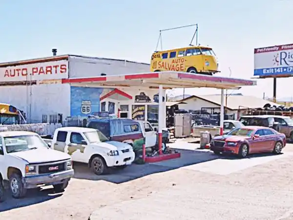
Ahead is Kingman's Whiting Bros. gas station located just east of McConnico, and it is still standing as Dans Auto Salvage
At 2666 S Highway 66, it is now part of a junkyard full of tires and rusting cars that provides scrap metal and car parts to those who need them.
Whiting Bros. and Route 66
> > Read more: Visit our Whiting Bros. and Route 66 webpage.
Learn all about the motels and gas stations of Whiting Bros along US 66 in New Mexico and Arizona.
The Historic Route 66 Back Country Byway
Back Country Byway
After visiting the former Whiting Bros. station, you can head west towards the Historic Route 66 Back Country Byway. The original 1940s to 70s alingment turned west just ahead, and these 1,000 ft. -300 m- are now under the freeway. It then headed towards Cool Springs and Oatman along current state Hwy 10 on the north side of the freeway.
We describe the highway from Kingman to Topock in our special Kingman to Topock Route 66 alignment page.

Back Country Byway sign. Austin Whittall.
This section of Route 66 from Kingman to Topock has been designated a Back Country Byway, within the BLM (Bureau of Land Management).
The road is legally accessible by any vehicle under 40 feet in length. The part of the road passing through the mountains is a very narrow two-lane with no shoulders, extremely tight switchbacks and many steep drop-offs. Wide vehicles and vehicles over 30 feet in length should use extreme caution when driving this road.
A US 66 Shield on the roadway
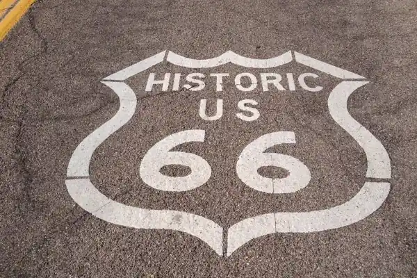
Just after you turn right onto the Byway you will see the Route 66 Shield painted on the road, shown below.
See this map with its location.
Shield on US66's roadway close to I-40.
Cool Springs
A Route 66 icon
20 miles west of Kingman on the original 1926-52 alignment of Route 66. (Map with directions).
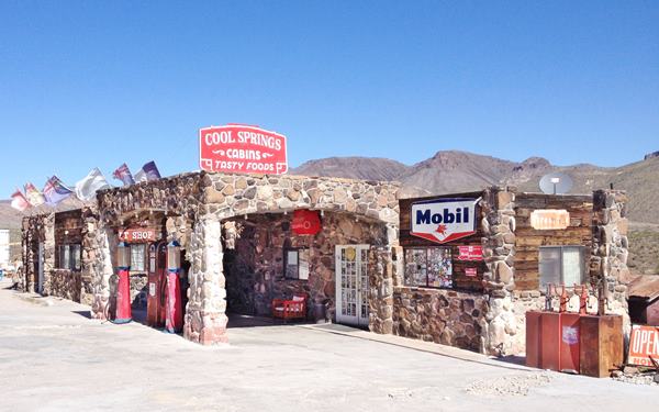
During the golden days of Route 66, Cool Springs was a stop on the road before facing the tough winding climb across the Black Mountains towards Sitgreaves Pass. There were cabins, food, fresh water, and gasoline.

It crumbled into disrepair when traffic fell off in 1952 when Route 66 was realigned through Yucca, now on I-40.
Ned Leuchtner bought it in 1997 and restored it to its former appearance. He reopened it in 2001. Stop at its gift shop and get some great views of Squaw tit mountain behind it.
See the US 66 Shield painted on the road in front of the old gas station.
A view of the rebuilt Cool Springs Gas Station
This leg of your Route 66 road trip ends here, drive west into Oatman the gold mining town in the Black Mountains, to continue your journey.
Outdoors, National and State Parks

Deer in Hualapai Mountain Park. Source
Hualapai Mountain Park
County Park
14 mi. from Kingman (Map and Directions). It is a forested mountain range that rises above the arid surroundings. It was home to the "pine tree people", the Hualapai natives.
Ten miles of trails for hiking, mountain biking, or riding. Picnic areas and camping spots. Skiing in winter. The park covers 2,300 acres and its elevation ranges from 4,984 to 8,417 feet. (1245 - 2567 m).
The Grand Canyon Skywalk
74 mi. See the Map with Directions.
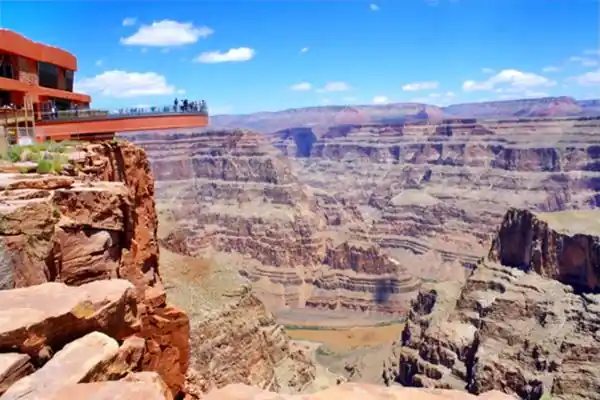
Opened in 2007, it is within the Hualapai Tribal land. It is a transparent horseshoe-shaped bridge that curves out and above the Grand Canyon
4,770 ft (1.450 m) above the Colorado River.
The best way to reach it is to take a tour, as the roads are not in top condition.
Read more at the Skywalk website.
Grand Canyon Skywalk
Tip: consider visiting the Grand Canyon on your Road Trip. You can drive Route 66 to Williams, AZ, and from there to the Grand Canyon.
Or you can make it an adventure: Take the Train to visit the Grand Canyon. There are daily "Williams Flyer" services between Williams and the Grand Canyon, plus other services (like the winter Polar Express), which use the restored Santa Fe Railway Station from downtown Williams. You can even sleep over at the hotel in the railway depot.
Grand Canyon National Park
World Heritage site of UNESCO
More Kingman Attractions
In the Previous Page (Page #1) we describe Kingman's Route 66 attractions, weather, maps and an overview of the city's history.
Credits
Banner image: Hackberry General Store, Hackberry, Arizona by Perla Eichenblat

