Route 66 Road Trip in Antares:
Index to this page
About Antares, Arizona
Facts, Trivia and useful information
Elevation 3,495 ft (1.066 m). Population 86 (2025).
Time zone: Mountain (MST): UTC minus 7 hours. Summer (DST) no DST⁄ PDT (UTC-7).
Antares is a tiny village in central Mohave County, on Route 66 in the northwestern region of Arizona, just north of Kingman.
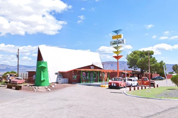
The former Rancheros Motel and the Giganticus Headicus Moai head at Antares
Antares: History
Check the History of Kingman, for full details on the region's history.
The Name: Antares
Antares is the name of a gigantic red star in the constellation of Scorpio. Its red hue and brightness resembles Mars hence its Greek name "Anti Ares" which means "the rival of Mars".
Antares is a supergiant star 10,000 times brighter and twelve times as massive as our Sun. It is so large that if it was located where our Sun it, it would extend all the way to the orbit of Jupiter, engulfing Vens, Earth, Mars and Mercury.
It is young, only 12 million years old (our Sun is over 4.5 billion years old).
When the the Atlantic & Pacific Railroad (later the Atchison Topeka and Santa Fe Railroad) laid its tracks through the area in 1883 they came across an obstacle: the Peackock Mountains just South of Hackberry.
They opted to route the tracks using the longer but easier alignment with a comfortable gradient that ran along the oriental foothills of the mountain range, with a nortwestern to southeastern course through Hackberry.
Six miles north of Hackberry the mountains were much lower (mere hills) so the tracks took a wide seeeping 90° curve, crossing the range and taking a straight course towards the southwest, all the way into Kingman.
It was, on this curve that a siding was built. It was named Antares, but no reason was given. Several trails converged here, at the foot of Indian Butte. We found its first record in a map printed in 1901.

Railroad map showing Antares. 1915 Source
A description of the area published in 1915 says:
Antares Elevation 3,608 feet... At Antares the railway reaches the summit of the low northern extension of the Peacock Mountains, the granite of which crops out on both sides of the track. A few miles north and northeast are the precipitous slopes of the Grand Wash Cliffs, which extend far to the north, crossing Colorado River 75 miles north of this place, at the western outlet or termination of the Grand Canyon.
These cliffs form the last step in the descent across the great succession of sedimentary rocks constituting the high plateau of Arizona. They are capped by the lower part of the Redwall limestone, lying on 500 feet or more of sandstones and shale of the Tonto group, and have a long rugged lower slope of granite descending to the Hualpai Valley. The line of the escarpment is nearly straight. Part of its height is apparently due to a fault passing along its western foot, with uplift on the east side, as shown in figure 34. This fault probably has a displacement of 1,000 feet or more, as indicated by the extent to which the strata are elevated.
...
From Antares to Kingman the railway ascends Hualpai (wahl'pie) Valley, a typical flat-bottomed desert valley, which extends north to Colorado River. It presents wide areas of smooth land with excellent soil and mild climate, which would yield large returns to agriculture if water were available for its reclamation. There is, however, but very little water underground, and although at the lower part of the valley is Colorado River, which carries a vast quantity of water, this stream lies more than 2,000 feet lower than the district visible from the railway. Pumping water to that height for irrigation is now regarded as impracticable. N.H Darton (1915)
The National Old Trails highway (N.O.T.) was built in the 1910s and it followed the railroad. Route 66 was built along that same alignment in 1926.

Where to Stay in Antares
Lodging & accommodation in Antares sponsored content. There is no hotel in town, but you can find one in neighboring Kingman.
>> Book your Hotel in Kingman
More Lodging Near Antares along Route 66
There are plenty of lodging options in the cities and towns along Route 66 east and west of Antares; click on the links below to find your accommodation in these towns, listed from east to west:
Eastwards
In Arizona Along Route 66
Westwards
You are so close to Las Vegas and the Grand Canyon!
>> RV campgrounds in Kingman
Weather in Antares
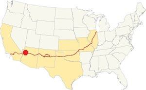
Location of Antares on Route 66
Antares has a "cold semi-arid climate"; the average temperatures during the year: summer high (Jul): 97.8°F (36.6°C) , summer low is 67.2°F (19.6°C). Winter high (Jan): 55.9°F (13.3°C), winter low is 31.1°F (-0.5°C).
Snow can dust the area ocassionally with around 3.7 inches (9.4 cm) yearly. It has 37 rainy days per year, with 19.3 in. of rain (263 mm). April, May and June are the driest months. August is the wettest.
Tornado risk
As the Antares is located to the west of the Rocky Montains there are virtually no tornados in this area.
Tornado Risk: read more about Tornado Risk along Route66.
Map of Route 66 through Antares Arizona
Alignment map in Antares
Visit our Williams to Kingman page for the description of this alignment. Below is the color coded interactive map:
>> Custom map of Route 66 in Antares

Thumbnail of the 1935 Arizona highway map. Source
Click on thumbnail map to enlarge
In 1926 Route 66 was aligned along the National Old Trails highway that followed the railroad tracks between Williams and Kingman.
See this Map with US 66 alignment across Antares.
The mother road stayed aligned through Antares until its final decertification. This is the Longest remaining segment of Route 66 in the whole of the U.S., and it ends at Topock on the Colorado River, at the California state line.
Getting to Antares
You can reach Antares along Historic Route 66 in Arizona from Selimgan (east) or Kingman (west) and reach any of those towns via I-40 or from Las Vegas, Nevada, by US 93
Route 66 Alignment near Antares
With maps and full information of the old roadway.
- Kingman to Topock (next)
- Williams to Kingman (Antares's)
- Winona to Williams (previous)

Antares' Attractions: Landmarks and places to see
Historic context, the classic Route 66 in Antares
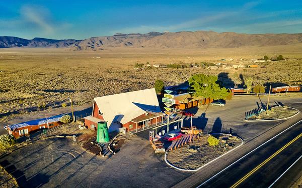
Aerial view of the Antares complex
Author Jack DeVere Rittenhouse wrote a great reference book for Route 66 fans, his 1946 "A Guide Book to Highway 66". It provides plenty of information about the Mother Road during its heyday period. However, Rittenhouse does not mention Antares. In his days it was merely a railroad siding and there was nothing there but the open Hualapai Valley after the route curved across the foothills of Peacock Mountains.

Guardian of Route 66 statue, Antares. Source
The Guardian of Route 66
This new statue was dedicated in Nov. 2021 by Gregg Arnold, creator of the tiki head; see this street view.
This shining metal statue stands 16-feet tall, a female wearing a crown and a mail coif, with a Route 66 shield on her left arm and an American flag on her outstretched right one. She combines the solemnity of Britannia (a very similar female statue) with the bravery of Delacroix's Liberty Leads the People.
It stands next to the Antares Point Visitors Center and Gift Shop.
Rancheros Motel
To your right, at 9855 E. Route 66 Antares. The Rancheros Motel opened around 1965. It is located beside the westbound lane of Route 66, on the Antares "curve".
Next to the old motel is Antares Road, a county road that begins at Route 66 and runs to the north northwest ending at Pierce Ferry Road, access to Meadview and the Colorado River at Lake Mead.
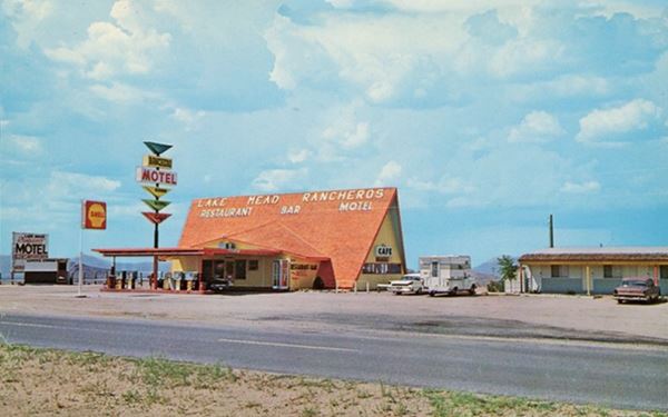
The motel's main feature was a steep gabled roof and a "space age" Googie styled sign with triangular shaped parts.
As you can see in the 1960s postcard, at one time it sported advertising on its roof: "Lake Mead Rancheros" (yes with an "s" at the end) followed by "Restaurant Bar Motel" and there was a Shell service station with the pumps under a now vanished canopy. To the north was the single story motel.
Lake Mead Rancheros is a subdivision of Mohave County.
Victor Ricciardi operated it in the early 1970s. Now it houses the Visitor Center and gift shop.
An unconfirmed urban myth states that screenwriter and producer Gene Roddenberry (1921-1991), the creator of Star Trek, spent a night in this motel and in consequence named one of the ships in ths series after Antares.
The former Rancheros Motel in the 1950s
The place was also the Kozy Corner Trailer Court, with the Kozy-mart convenience store that included a Laundr-O-Mat.
Now, long after it closed, it has a kitschy Route 66 attraction, a gigantic Tiki head, the Giganticus Headicus.
Giganticus Headicus
The gigantic Tiki head
Wacky Route 66 sights, the Kitsch and Americana on Route 66

The Giant Moai (Giganticus Headicus) in, Antares, Arizona. By Source
Located on the west side of the former motel's entrance, it is the kind of landmark that at one time was characteristic of Route 66, a big, weird statue which is on par with other similar wacky Americana icons like the Blue Whale (Catoosa, Oklahoma) or The World's Largest Totem Pole (Foyil, Oklahoma) or the Granny's Closet - Lumberjack (Flagstaff, Arizona), just to mention a few of them.
But this is no "classic" landmark, as it is relatively new: it was placed here in 2004.
Gregg Arnold, the creator of the Giganticus Headicus, moved west to Kingman from the East Coast in 2003 and settled on a 3-acre piece of land at the corner of Antares Road and Route 66. It is here that Gregg created is work of art, "Giganticus Headicus".
It is often described as a gigantic Tiki head (hence its latinized toung-in-cheek name).
The massive object is large: it is 14 feet high (4.27 m). It's painted green and was built with wood and plastered with stucco to give it a stone-like surface.
The Giganticus Headicus is famous
Giganticus Headicus or GH for short was chosen as one of the top 60 things to see while traveling across the U.S. in Nabisco's Cheez-It "Real American Road Trip" campaign of 2012, and in many "Must-See" lists of Arizona.
A Tiki or a Moai?

A Moai in Easter Island, Source
Tiki is a Maori (the New Zealand natives) myth. He was the first man who, with Marikoriko, the first woman, fathered mankind. The word tiki is applied to stone or wood carvings depicting him.
Moai, on the other hand are the gigantic human figures carved in stone on Easter Island (Rapa Nui) and, according to legend they were modeled after stone figurines brought to the island by their mythical first chief, Hotu Matu'a.
Tiki's come in a variety of shapes but the word does not exist in Easter Island or Western Polynesia. Moais are not Tikis, and are unique to Easter Island. They were carved out of volcanic rock and erected between 1250 and 1500 AD.
Their main feature are their gigantic heads almost half the size of the body. They represented the living or ancestral chieftains, abodes of their spirits, who guard and oversee the villagers, that is why they face inland.
Comparing both images, we can see that GH seems ot have been inspired in the Moais: his rugged surface, and heavy brow are moai-like, but the round cylindrical eyes and the lack of a mouth set him apart from them.
This marks the end of this leg of your Route 66 Road Trip, continue your journey by heading west towards Kingman.
Attractions close to Antares
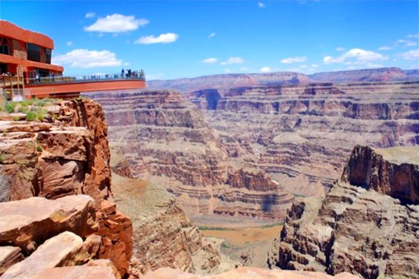
The Grand Canyon Skywalk
62 mi. See the Map with Directions.
Opened in 2007 it is within the Hualapai Tribal land. It is a transparent horseshoe-shaped bridge that curves out and above the Grand Canyon 4,770 ft (1.450 m) above the Colorado River.
The best way to reach it is taking a tour as the roads are not in top conditions.
Read more at the Skywalk website.
Grand Canyon Skywalk
Lake Havasu City
Some sponsored content

Lake Havasu City, the lake and London Bridge. Source
The resort town of Lake Havasu City on Lake Havasu has beaches along the lake's scenic shoreline, an active nightlife and the original London bridge (you can take a Tour to visit it)
The adjacent state park is open 24 hs, and there is an entrance fee. It is located on a reservoir on the Colorado River. You can hike and enjoy the riverside.
Visit the scenic shoreline with beautiful beaches, nature trails, boat ramps, and many convenient campsites.
>> Book your Hotel in Lake Havasu City
Learn more about the outdoor sites in the Havasu State Park official website.
>> Book your Hotel in neighboring Kingman AZ


Credits
Banner image: Hackberry General Store, Hackberry, Arizona by Perla Eichenblat
Antares Point facebook page
Jack DeVere Rittenhouse, (1946). A Guide Book to Highway 66.


