Route 66 in Odell IL
Index to this page
About Odell IL
Facts, Information and trivia
Elevation: Elevation 713 ft (217 m). Population 980 (2024).
Time zone: Central (CST): UTC minus 6 hours. Summer (DST) CDT (UTC-5).
Odell is a village in north-central Livingston County with two Route 66 alignments crossing it.
History of Odell
See the History of Pontiac for a description of the early history of Livingston county.
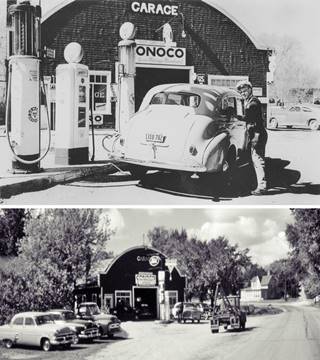
A vintage car at the Standard Oil Filling Station in Odell, Illinois
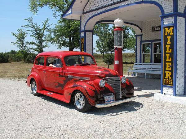
When the first pioneers arrived in 1830, there were still Kickapoo Indians in Livingsgton County. But shortly after they were displaced west of the Mississippi River and eventually further west into Oklahoma.
Livingstone County was established in 1837, but settlement would have to wait until the railway, authorized by the state legislature in the early 1850s, reached the area.
Two entrepreneurs and speculators, knowing this (they were James C. Spencer and Henry A. Gardner), had bought up the land on the proposed Chicago & Altona railroad's right of way in 1853. Spencer then sold his land to William H. Odell that same year and in 1855 Gardner and Odell became partners.
The town was platted in 1856 by Sydney S. Morgan who had bought Odell's share. It was formally organized in 1867.
The village of Odell was a farming community. In 1915 the "Pontiac Trail" a hard surfaced road built for cars along the former stagecoach route to Springfield was aligned through it. The Trail was later improved and paved when State Highway 4 was laid along its alignment. In 1926 Route 66 was created absorbing the roadbed of former State Highway 4. In the 1940s a bypass U.S. 66 aligNment was built around the town's western flank. Odell remained on US 66 until it was delisted in 1977 once I-55 bypassed the town.
The Name: Odell
It was named for one of its founders. The surname is a place name: Odell (Bedfordshire), England, which combines the Old English word "wad" (woad a plant that provided a blue dye) and "hyll" (hill), so Odell was he who lived by the hill where the woad grows.
A local resident, Rita Erickson (1919-2012) was inducted into the Illinois Route 66 Hall of Fame; she "committed her life and career to the community of Odell ... all of this in respect to Route 66 and its residents." In 1961, she bought the home of John Williams, a local banker and turned it into the "Odell Shelter" for the elderly that could accommodate 23 people.

Odell: Hotels and Motels nearby
Find your accommodation near Odell
> > Book your hotel in neighboring Pontiac
Find More Accommodation near Odell along Route 66
Below you will find a list of some of the towns along Route 66 east and west of this town; click on any of the links to find your accommodation in these towns (shown from east to west):
Along Route 66 in IL
- Hotels in Illinois
- Route 66 Starting point ▸ Chicago
- Lockport
- Willowbrook
- Bolingbrook
- Plainfield
- Romeoville
- Joliet
- Wilmington
- Dwight
- Pontiac
- Chenoa
- Normal
- Bloomington
- Atlanta
- Lincoln
- Springfield
- Raymond
- Litchfield
- Staunton
- Williamson
- Hamel
- Edwardsville
- Collinsville
- Troy
- Glen Carbon
- Pontoon Beach
- Granite City
- East St. Louis
West in Missouri
- Hotels in Missouri
- Florissant MO
- Bridgeton MO
- St. Louis MO
- Kirkwood MO
>> See the RV campground in Pontiac
The Weather in Odell
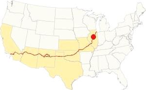
Location of Odell on U.S. Hwy. 66
With a Humid Continental climate, summers in Odell are very wet and hot and its winters are quite cold and with plenty of snow.
The average winter (Jan) temperatures are: high, 30°F (-1 °C); low, 17°F (-8.3 deg;C).
The average summer (Jul) tempearatures are: high, 85°F (29.7°C); low, 63°F (17.2°C).
There are 71 days of rain each year, and around 38 inches fall on average (965 mm). The sun shines on 194 days each year. Snow may fall between November and early April, and 26 inches (66 cm) fall on average each year.
Tornado risk
A tornado struck Odell on May 12, 1886 over 130 years ago.
Livingston county, where Odell is located gets around 6 tornado strikes each year.
Tornado Risk: read more about Tornado Risk on US 66.
Map of Route 66 through Odell, Illinois
Route Alignment
>> Our Custom map shows the alignments of US66 in Odell.
1926-45 two-lane Route 66
The original alingment runs along the west side of the commercial district following E Prairie, N West and S West Streets. Shown with a violet line in our interactive map.
1945 -1977 alignment (4-lane '66)
The highway was upgraded to carry heavy wartime traffic during WWII, and a new set of lanes was built west of the original alignment, bypassing the town. A second set of lanes were added in the early 1950s. South of Odell these lanes are now buried beneath the current northbound lanes of I-55 (green line).
Route 66 is a Historic highway and has also been designated as a National Scenic Byway and an All-American Road in the state of Illinois.
The Route 66 alignments near Odell
Description and interactive maps of US 66.
- Pontiac to Springfield (next)
- Chicago to Pontiac (Odell's)

Odell's Sights and Route 66 Attractions
What to see in Odell
US 66 in Odell: historic context
Jack DeVere Rittenhouse published his "A Guide Book to Highway 66" in 1946 after driving along Route 66, and it gives us a good idea of what the towns along it werer like during the route's heyday. His entry on Odell says:
the town of Odell... lies east of US 66 at this point... garage, etc. in town... One mile south of town there is a gas station on the highway Rittenhouse (1946)
It seems that Rittenhouse was driving along the bypass alingment as he only mentions the mile station but not the famous Standard Oil filling station or the Mobile Gas Station on the "Old" alignment, he does however mention a "garage" in town, perhaps Jones.
Drive US 66 through Odell
Drive westwards coming from Dwight the highway runs beside the freeway most of the way. The Interstate curves westwards and the original westbound lanes of the 4-lane Route 66 appear to your right, one mile aheadthe original 1926-40s Route 66 forks to the left as O'Dell Rd. or North West Street. The original highway is narrow, and runs beside the railroad with a SW course while the 4-lane '66 curves towards the west.
When it reaches the north side of Odell, it curves west along E Prairie St.
Boyd's Place (gone)

1951 aerial view of Northern Odell. Source. Click image to enlarge
Inducted into the Illinois Route 66 Hall of Fame, June 11, 2011.
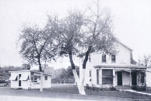
Boyd Seth Fairchild (1882-1963) moved to Odell when he was twenty two with his wife Catherine, and worked there as a painter-contractor and owner of a lunch-room on Route 66. He ran his restaurant with his brother Ray. They opened it in 1925 on what then was Illinois State Highway 4. The place is gone, but it stood on the SE corner of E Prairie and N Wolf St. (street view of the site where it stood). We marked it with a ① in the aerial image taken in 1951 (click on it to enlarge it). The diner is pictured on the left side of the picture below "Boyd's Place - Hot Coffee - Lunch".
"Dick" Jones Garage (gone)
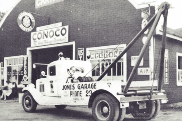
On the next block, to your left was the brick faced garage owned by J. Richard "Dick" Jones. We marked it with a ② in the aerial view further up. It was
Inducted into the Illinois Route 66 Hall of Fame in 1998.
He opened it in 1940, and had a Conoco filling station with three pumps facing Route 66, a wrecker for towing cars and trucks, and a Ford dealership that began in 1943 and lasted till he resigned in 1959.
His sons Jim and Gene also helped in the garage. Dick can be seen in the small image (bottom) click on it to enlarge
The building is gone, this is a street view of the spot.
Three gas stations and a cafe (gone)
Continuing straight along Prairie St. to the crossroads with the Bypass U.S. 66, there were three gas stations built there in the late 1940s, early 1950s (they were not there when Rittenhouse drove by in 1946). The buildings have all gone and nothing remains of them. Below is a brief description and some views of them:
Al's Odell Standard Service
There were several Standard stations in Odell over the course of the years, this was one of them. It was located where the BP station stands on the NW corner of the crossroads. Pictured below in 1965; the 1955 aerial photograph book of Livingston County shows it captioned as "Al's Service Station - Odell."

1965 aerial photo, Standard service station. Source. Click image to enlarge

1965 aerial photo, Phillips 66 service station. Source. Click image to enlarge
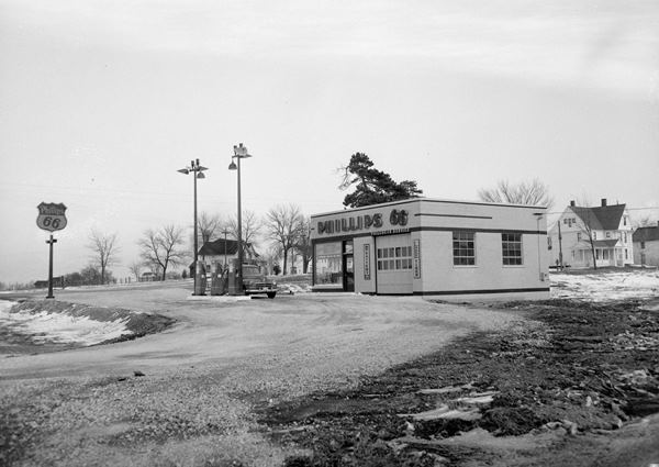
Odell Phillips 66
The Odell Phillips 66 station was operated by Frank and Thomas Zebell in the 1950s it was located on the SE corner of the crossroads. Pictured above in 1965, and below in the 1950s. The White Kitchen was next to it, also gone.
John Fogarty's Mobil Station

1965 aerial photo, Mobil service station. Source. Click image to enlarge
This station was located on the SW corner with W Prairie St.
Back to City 66
These were the gas stations built on the later alignment of Route 66. Now we will return to the original alignment at Jones; just one-half a block west, at the corner with N West St, the "Old" Route 66 curved with a NE to SW course.
North End Standard Station (gone)
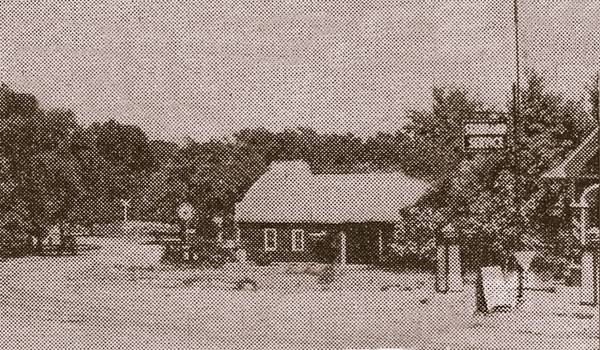
Here by the curve there was another gas station from the 1920s it had a gable roofed canopy and a woodframe building. It was located on the NE corner of Scott St. and N West St. a Standard Station known as Benedict's, Keesler's, or North End Standard Service. Nothing remains of it, below is a view looking east from the curve; you can see Jones Garage to the left, and on the right side of the image, the sign and canopy of Keesler's station.
Fortner's Restaurant and Gas Station (gone)
Continue four more blocks to Tremont St.
To your left on the NW corner were two buildings, the corner property was a hip-roofed restaurant owned by Bill Fortner, "Bill's Lunchroom" and next to it was the small gas station with a gable roof that covered both the office and the canopy over its three gas pumps.
Fortner had purchased it from Sweney Oil Co. The restaurant burned down in 1938 and Fortner sold out to Peter Paul Schook (1891-1946).
The gas station remained open longer and it appears in an aerial photo taken in 1951, Francis "Frank" Joseph Noonan (1891-1967) was its last owner.
The hip roofed brick house on the property was built in the 1950s.
Stoney's Mobil Station

Stoney's Service, 1955 ad. Source
On the next block, to your left, at 108 S West St between Tremont and Hamilton is the former Stoney's Service Station.
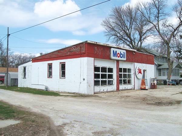
It was the last gas station owned by John Kilby "Stoney" Stonecipher (1920-2009). He started fixing cars while he was in the Marine Corps during WW II. After the war he worked as a painter for some years and in 1948 bought Fred Goodman's Garage and Marathon station, that later became a Phillips 66 station; it was located in Downtown Odell, where the fire station is now locagted. In 1955 the building was destroyed by a fire with losses of at least $100,000. The community and the Odell Legion supported him and raised over $2,000 which allowed him to move to this new site three months later on Jan. 1, 1956. It had been a Ernie Porter's welding shop. He ran it as a Mobil station until he retired in 1989.
Stonecipher was inducted into the Illinois Route 66 Hall of Fame in 1992.
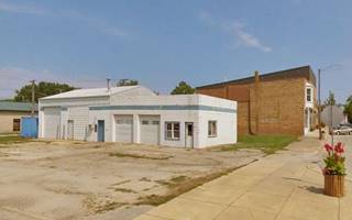
This former Mobil service station has a two service bays with a box shaped building with a slanting roof.
Stoney's Mobil Gas Station in Odell, Illinois
Odell Subway Tunnel
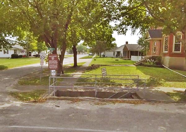
Just ahead, on the next corner; south side of Hamilton St and West St is the now closed pedestrian underpas built in the 1930s.
Traffic through Odell along U.S. Highway 66 was quite heavy. This is hard to picture nowadays as you gaze down the quite residential district's street,but at one time hundreds of trucks and cars drove by constantly.
The students and those going to Saint Paul's Church had to dodge the traffic to get across the road, which was dangerous. So the authorities built a pedestrian tunnel which the locals named the "Subway," so that the neighbors could cross the street safely.
There is a brown sign with details about the underpass.
It was built in 1937 and remained in use until the Bypass Route 66 was built in 1944, this took the traffic away from the neighborhood. The tunnel was filled in in 1947, sealing it off.
The Route 66 Association of Illinois did their piece of archaeological work, and in 2006 dug up the first three steps, exposing the concrete structure and steps. They added new railings that are a replica of the original ones and completed their work with adequate signs about the pedestrian underpass.
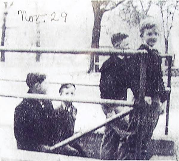
The photograph below shows some young children using the tunnel.
Odell Pedestrian Tunnel in use in 1937, Odell, Illinois
Kelso's Mobil
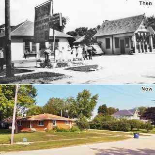
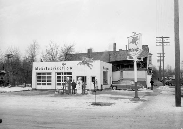
To your right, two blocks away towards the east is the commercial district of Odell, here there were stores, restaurants and another Mobil gas station, on the NW corner of Hamilton and S Waupansie streets.
In 1954 it was managed by Joseph Kelso, and it had been built on the site of the Eastern Hotel that had been destroyed by a fire. The images show it in a "Then and Now" sequence. Notice the same red-brick building behind, with the bay window.
Return to Old Route 66 at the subway, turn left and head south along the highway, two blocks south (0.1 mi) the highway curves and to your right are the sites of two landmarks, and also a surviving Route 66 classic.
Trecker's Sinclair (gone)
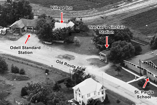
To your left, after passing the building of St. Paul's School (200 S West St.) is an empty lot once occupied by Trecker's Sinclair station. It can be seen in the image below.
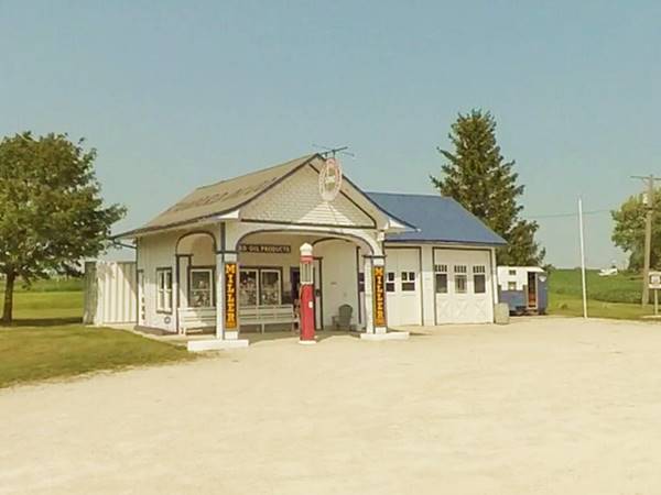
Ahead, also to your right is the best known Route 66 sight in Odell, its Historic Standard Station.
Standard Oil Gasoline Station
Listed in the National Register of Historic Places - Route 66 Roadside Attraction
At 400 S West St
Built by Patrick O'Donnell in 1932, just six years after Route 66 was aligned through Odell. He purchased a small plot of land (200 by 60 feet) from Francis J. and Grace E. Craven. He used the 1910s "House and Canopy" or "Domestic" style, it was just that, a small box-shaped gabled house with a gabled canopy. The two garage bays on its northern side were added later in the late 1930s.
Historic Standard Oil Gasoline Station in Odell, Illinois
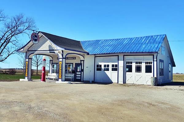
O'Donnell sold Standard Oil gasoline and oil, but later switched to Phillips 66 and Sinclair. In 1952 he rented it to Robert Close, who ran the cafe next to it (building now gone) who after the death of O'Donnell in 1957, bought it for $1,550.
Close sold gas until 1967 and after that date, used the building as a repair shop. It fell into disrepair. Close sold it to the Village of Odell in 1999 who wanted to restore it.
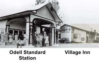
Village Inn (gone)
There was a bar and restaurant a few yards to the north of the Standard station that offered dinners, steaks, and was a Café. Frank Verdun opearated it. It later became a house and a fire destroyed it.
The image below (click on it to enlarge it) is a composite of a 1930s view of both buildings and a 1950s view of the restaurant.

Kirchner's Cafe and Service, 1965. Source. Click to enlarge
Mile Station and Restaurant (gone)
Drive westbound along the old Route 66 and one mile south of Odell was the "Mile Station" mentioned by Ritten house in 1946. At 2500 N Rd. and Route 66 west SW corner
In its early days Al and Ruth Blessing operated it; it was the only gas station south of town and when the bypass alignment circled the town, they were the only gas station on the alignment in Odell.
The original building had a small office with a hip roof, and a gable roof canopy over box columns facing the highway (similar to the Historic gas station), the canopy read "Ruth's Cafe". Later the canopy was enclosed and the building expanded.
Al Blessing ran the gas station during the 1950s, and appears in the Centennial book of Odell (1954) and in a newspaper article (1959). Later, Clarence E. Holderidge (1903-1993) who was the owner of the Cozy Inn in neighboring Pontiac acquired it and ran it with his wife Ruth Davis (Fitzgerald). The last owner in the 1960s was Kirchner, and the image below shows Kirchner's Phillips 66 Service & Café (Open 24 hours, with home made pies). This is a satellite view showing the foundations of the site, as you can see in this picture.
Continue your Route 66 Road Trip
This ends your drive through Odell, head west to visit Cayuga to continue your Route 66 road trip.

Sponsored Content
>> Book your Hotel in Chicago

Credits
Banner image: Hackberry General Store, Hackberry, Arizona by Perla Eichenblat
Jack DeVere Rittenhouse, (1946). A Guide Book to Highway 66.


