Index to this page

Mural in Pontiac, Illinois. Source
See our custom interactive Chicago to Pontiac - Map of this segment.
Chicago to St. Pontiac itinerary and alignment
Illinois Route 66 Itinerary and maps
Each leg of Route 66 described below has an interactive map and many image maps so you can follow the alignments of the highway along the way:
- This leg: Chicago to Pontiac - Map of this segment.
- Pontiac to Springfield - Map of this segment.
- Springfield to Staunton (1926-30) - Map of this segment.
- Springfield to Hamel (1930-1977) - Map of this segment.
- Hamel to St. Louis - Map of this segment.
Missouri, next leg
Chicago to Pontiac along Route 66
Chicago Illinois' Route 66
This leg of Route 66 begins in the city of ChicagoIllinois. There have been several alignments of the highway across the town, the first was the "Pontiac Trail" that predated US66 by eleven years.
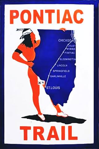
The Chicago Trail symbol shield
History: The Pontiac Trail, State Highway 4 and Route 66
In1915, a private association promoted and built the Pontiac Trail with the goal of having a reliable main road linking the two great cities of Chicago and St. Louis. It had been named after the famous Ottawa Indians' chief, Pontiac, and the tire company B.F. Goodrich provided the milage posts; it even had its own shield sign (see image).
There was also intense lobbying for the state to take care of its roads and build decent highways. This led to the state of Illinois to issue a bond in 1918 to build hard surfaced roads across the state.
The Pontiac Trail was designated to become the SBI 4 (State Bond Issue) highway number 4.
Federal funds were also provided for this purpose and the road was paved along its whole length by 1923. It had a winding course, following the railroad and county lanes but it provided a good road between both cities. It passed through Chicago and the state capital in Springfield, reaching St. Louis.
Route 66 was created in 1926 and it used pre-existing highways as its first alignment; in this area it used State Hwy. 4.
We will describe the alignments of Route 66 from Chicago to Pontiac, starting at the highway's eastern terminus in Chicago.
Chicago's Route 66 alignment
Chicago, the End and Beginning of Route 66
Route 66 was created in 1926 to link Chicago with Los Angeles, and unlike the Interstate highways whose exits are numbered from west to east or from south to north, U.S. Highways don't have a beginning or an end, or do they?
Chicago: The starting point of Route 66
Even so, Chicago is considered as Route 66's "Starting Point": From here people headed west to seek new lives, jobs or vacations. The destination lay in the west, making Santa Monica CA the The Western Terminus of Route 66 or "End of the Trail" for Route 66. So Chicago was where it began.
First starting point - State Hwy. 4

1928 Illinois State roadmap (see State Hwy 4A). Source
Click map to enlarge
Joe Sonderman in his "Route 66 in Illinois" tells us that Illinois state highway 4 "was assigned to the route from Forty-eighth Street and Ogden in Cicero to East St. Louis", that is, where Harlem and Ogden meet on the border between Lyons and Cicero.
Lemont
This highway number 4 ran southwards this point, through Summit, Justice, and with a SW course to Lemont and then via Lockport to Joliet Joliet on the south side of the Des Plaines River. It was paved in 1923.
In 1928 another brand new paved alignment was built along the north side of the river between Joliet and Lyons through Romeoville, Willowbrook and McCook, becoming Route 4 (the older alignment was renamed Route 4A as you can see in the map (click to enlarge), that is nowadays Illinois Route 171.
Route 66 is created
When that same year, 1926, U.S. Highway 66 was created, it ran along the new IL-4 roadbed from Cicero to Joliet.
The first segment: Chicago to Cicero
Russell A. Olsen in "The Complete Route 66 Lost & Found" reports that the eastern terminus at 48th St. and Ogden Ave. in Cicero and was moved east into downtown Chicago in 1931, to Jackson St. and Michigan Ave. in Grant Park.
The State maps of 1926, 27 and 28 show Route 66 as continuing with IL-4 west of Cicero so perhaps its terminus was unclear to map makers. See the pale blue line in our interactive map with directions.
Another change took place in 1957 when Jackson St. west of Michigan Ave became one way (eastwards) as shown with a blue line in our interactive map.
This meant that westbound traffic from US 41 (which ran along Lake Shore Blvd.) drove along a "two lane" Jackson until reaching Michigan Ave, but then had to turn north and then again, west, along Adams St. to head westwards to reach Ogden Ave.
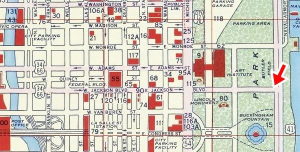
The 1956 Shell Oil Road map of Downtown Chicago (below) shows us a new Jackson Blvd. linking Michigan with Outer Drive (Route 66 ends at the red arrow):
1956 Shell Oil map of Downtown Chicago, Illinois
The following photograph was taken in Grant Park on Jackson Blvd. looking east towards Lake Shore Blvd in the 1950s, and shows as white sign with black letters proclaiming the "END OF ROUTE 34 -66":
End of US 66 and 34 1950s in Chicago, Illinois
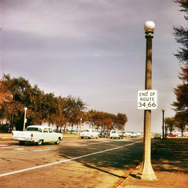
The "End" for Route 66
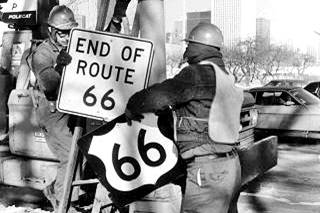
Route 66 shield being removed, Jan 1977, Chicago. Source
The signs were all removed when U.S. 66 was decertified. This took place in Grant Park on January 17. 1977 and there is a great photograph of this event showing two workers removing the US 66 Shield and the "End of Route 66" sign on a chilly January day. In the background you can make out the Aon Center skyscraper (in those days it was the Standard Oil Building, completed in 1974).
New Beginning and New End Signs
The 1992 "Route 66 Law" or "U.S. Route 66 Designation Act" designated the existing portion of Route 66 in Illinois as a State Historic Highway. In consequence the former US 66 was marked with the typical brown signs across the state of Illinois, signs that include those at its Eastern Terminus, the road effectively got a new "start".
Route 66 'Begin' Sign
Don't miss the start "Begin" point at 99 E Adam St. (NW corner with Michigan Ave.):
Route 66 "Begin" sign, in Chicago, Illinois
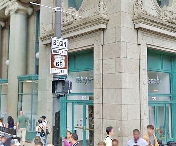
There is another "Begin" Sign on the opposite side of the street, just west of this one.
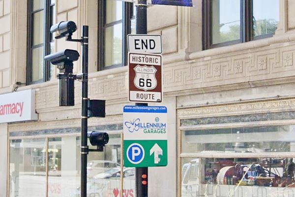
Route 66 'End' Sign
But as we said before, Route 66 also "Ended" in Chicago -for those driving eastwards, and the sign is there too, one block south, on E Jackson St. almost at Michigan Ave:
Route 66 "End" sign, in Chicago, Illinois
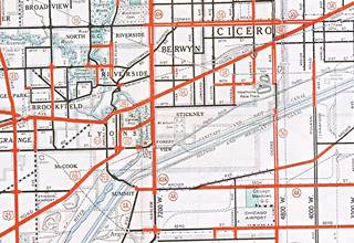
1934 map of Route 66 in Chicagoland. Source
Click map to enlarge
As shown in the map (click on it to enlarge), Route 66 followed Ogden Avenue with a NE to SW course, through Cicero.
Ogden Avenue
It was named after Chicago's first mayor: William Butler Ogden, this throughfare runs for 37.5 miles (60.4 km) from Chicago (Chestnut St. near Milwaukee and Chicago Avenues) all the way to Naperville, IL.
It has ancient origins: when Chicago was a fort on Lake Michigan (Fort Dearborn) in the early 1800s, the trappers used a muddy track known as "Ottawa Trail" that linked the fort with what nowadays is the villge of Lisle.
The trail was improved and a stagecoach service was established, stopping at what now is Hinsdale in the 1830s, but the cart traffic ruined the dirt road, forming ruts that turned it into a muddy bog during the rainy season. In 1848 some entrepreneurs built a toll road known as "The Southwestern Plank Road." It was the first of many that would radiate from Chicago. This one followed the trail to Lyons and in 1851 it was extended through Lisle to Naperville.
The road was built with wooden planks with log stringers on their outer edges. The boards were 3 in. thick and only 8 feet wide; toll fees were charged ranging from 3¢ for one hog or sheep, 12¢ for a horse and rider to 37¢ for a cart drawn by four hourses.
When the Chicago, Burlington and Quincy railroad began operating in 1863, the traffic along the plank road declined. It was re-named in 1877 as Ogden Avenue. and the planks removed to make it a gravel surfaced road. By the early 1900s the first cars appeared, and by 1914 it had been paved becoming a main throughfare. Route 66 and US 34 were aligned along it in 1926 and in the 1930s it was widened to four lanes.
Cicero's Ogden Avenue Bridge (gone)
See the different alignments here in our custom map. Blue is the original 1929-40 roadway, green is the 1940-98 steel bridge. Pale Blue is the current alignment.
When Route 66 was created, it was aligned along Ogden Ave. and here it met the combined tracks of the Chicago & Illinois Railway and the Belt Railway of Chicago, that had a north to south course, and cut across the avenue. Both railroads had multiple spurs into the warehouses of the factories in Cicero and Chicago.
The Chicago, Burlington and Quincy Railroad that ran with an east to west course, crossed linked to the other two railways here and crossed Ogden. It was a dangerous grade place for a grade crossing so the original alignment solved the problem by running north of the CB&Q railroad and then turning sharply south into the Cicero Ave underpass, and then again sharply west along Ogden, as shown in the map below (Route 66 runs along the red line).
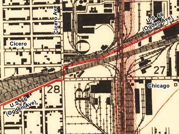
The two right angle turns were inconvenient, and the 31,000 cars a day that passed under the tracks caused frequent traffic jams, so in 1940 a bridge was built here to cross the tracks.
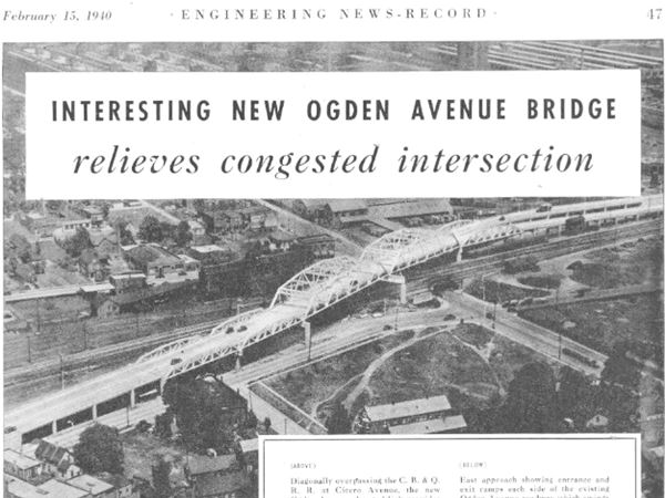
It had five truss spans 121 to 233 feet long and a 44-foot wide roadway with two beam spam aproaches on each side. It was 1,520 feet long and used 2,200 tons of structural steel.
Its eastern access had two independent ramps on each side of Ogden Ave, which continued straight to connect with Cicero Ave.
The image above looks towards the northeast, with Chicago to the right and Cicero to the left. See the same view nowadays.
The bridge grew old and weight restrictions were imposed, the right lane was closed to traffic. It was close to collapsing so it was taken down in 1998 and the current alignment opened in 2001.
Berwyn
Ogden crosses Cicero along 2.5 miles, and then runs for 1.5 miles across Berwyn with a NE to SW course and enters Lyons.
Lyons
Just west of Berwyn, the highway crossed the Des Plaines river and entered Lyons along Ogden and then south on Lawndale Ave. (orange line in our interactive map).
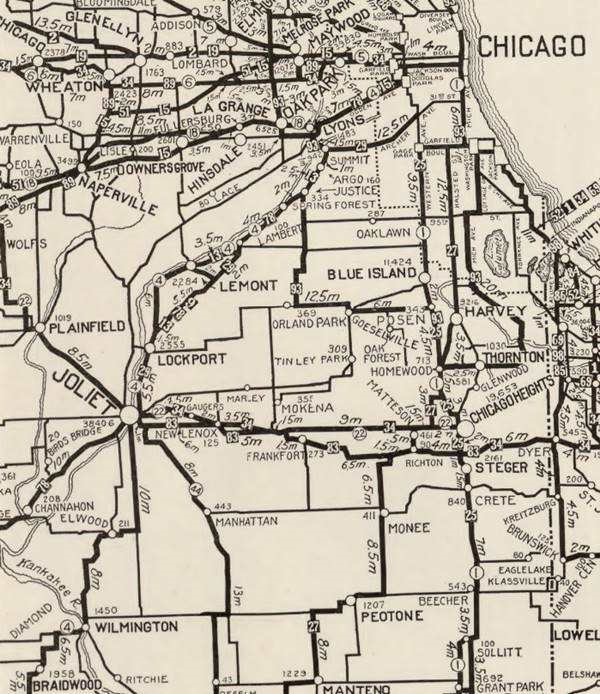
The map above was published in 1924, two years before Route 66 was created. It displays the "Auto Trails" or roads that could be driven by cars; notice "34" for the "Lincoln Highway" through Joliet and Plainfield, or "13" for the "Mississippi Valley Highway" from Lyons, through Lockport. The number "4" inside a white circle is State Highway 4.
Route 66's first alignment in 1926
Marked with a bordeaux line in our interactive map.
Route 4 was paved completely by 1923 so it was the logic choice for the alignment of Route 66. Both highways overlapped until the signs of the old state higway were finally replaced by the U.S. 66 shields in 1927.
Through Lockport
So it ran from Lyons to Summit, Lemont and Lockport as a "temporary 66" while the main alignment was being built further west (from Lyons to Joliet through Romeoville).

1928 Illinois State roadmap (see State Hwy 4A). Source
Click map to enlarge
Route 4A and the new Route 66 alignment (1928?)
But soon the new roadway that ran along the north and western side of the Des Plaines river in a straighter course across open countryside with farms and fields (the current town of Countryside on this alignment got its name for this reason). The new alignment avoided the urban crossings of Summit, Justice, Argo, Lemont and Lockport; it also eliminated many sharp curves and turns.
The new alignment was re-designated as both US 66 and Route 4. The old alignment was designated as Route 4A. You can see it in the map further up.
The 1929-1977 road was also realigned in Lyons as marked with a pale blue line in our interactive map with directions.
McCook
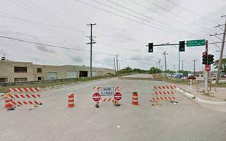
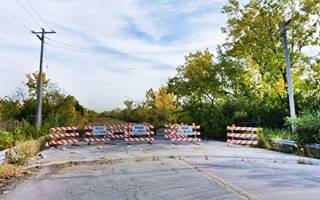
The highway headed towards the SW. Now it passes under IL-171, curving softly, continuing through an industrial neighborhood in McCook. Ahead after the overpass across the railroad tracks to your left is the vast quarry of Vulcan Materials Company, and just ahead Route 66 has been closed to traffic and it is shown with a green line in our interactive map.
Closed Section of Route 66
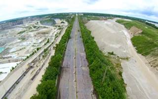
Aerial view, thumbnail from the "Route 66 Off Limits" video by Roamin' Rich
In 1998 a one-mile section of the highway buckled and broke. This disrupted traffic so the road was closed and traffic re-routed along a detour (55th St. and East Ave.)
The quarry that is located on both sides of the highway and is operated by Vulcan Materials Co. (the second largest mining company and producer of aggregate in the world), had undermined the bedrock foundations of Route 66.
The road ended up located on a narrow strip of limestone, resembling a long ridge, with sheer drops on both sides into the depths of the quarries. Definitively closed as it was too dangerous, the Illinois DOT filed a suit against Vulcan that same year stating that Vulco had mined limestone too close to the highway, damaging it. The lawsuit was settled by Vulcan who payed $40 million to the state of Illinois, though they didn't admit any liability.
Below are two views showing the northern and southern tips of the closed US 66 segment (click on them for a St. view):
Evolving from countryside to suburbia
The area west of Lyons was open countryside in 1926; the Illinois State Roadmap of 1928 shows no urban areas along US66 north and east of Joliet all the way into Lyons, that first town on the alignment. To the north lay Hinsdale and Lagrange, but the first town was Lyons, followed by Berwyn, Cicero and Chicago.
By 1945, according to the Illinois state's official Highway map, things had changed, not oly had US 66 moved to a new alignment through Plainfield, now "Romeo" (yes, not "Romeoville") appeared on ALT 66 north of Lockport on the former 1926-1939 US 66 through Joliet. The urban sprawl had reached Lyons, but to the west there were no other towns until you reached Plainfield.
The 1954 map shows the same picture but by then US 66 from Berwyn to IL-53 and then south as ALT 66 through Joliet and all the way to Wilmington was a "Four Lane Pavement" the main US 66 west of this point, through Plainfield and Braidwood was narrower, with a "Two Lane Pavement".
There are changes in the 1959 state highway map: US-66 south (west) of its junction with ALT US 66 has become an "Expressway" with "highway separation" (overpasses and limited access). This freeway bypassed Plainfield, and the former 1940 to 1958 US-66 road became state higways 126 and 59.
During the 1960's, the suburbs expanded and the 1969 state highway map showed I-55 and US 66 running together eastwards all the way to the exchange with I-294. Splitting here: with I-55 taking a more southern course and US-66 a northern one.
Leaving Chicago Behind
Countryside
The suburban sprawl that followed the post World War II period began expanding westwards and this area was developed during the housing boom during that period (1947 and 1950s). A bedroom community for neighboring Chicago, it finally incorporated as the City of Countryside Countryside in 1960. Shortly after, the I-55 Freeway was completed and US 66 ran along it westwards until its decertification in 1977. Our interactive map with directions shows this segment of US 66 with a pale blue line. There is a gap at Flag Creek, and the alignment of Old Route 66 runs along the North and South Frontage Roads and in parts is overlaid by the freeway.
Willowbrook
The highway goes through Willowbrook and other communities like Darien and Burr Ridge that in the 1940s and 50s didn't exist. The alignment is shown with a violet line in our interactive map.

Two different alignments of Route 66
West of Willowbrook, Route 66 took Joliet Rd., with course that curved south along the western side of the Des Plaines River and went through Romeoville, Joliet, Wilmington and Braidwood along what now is IL-53.
State Highway 126 continued with a NE-SW course into Plainfield. But, by 1939, traffic had increased along Route 66 so a straighter alignment was designated along IL-126 into Plainfield and a new roadway was built (present IL-59) in a straight north-south course all the way to Braidwood, where it met the old alignment but ran parallel to it, on the west side of the railroad tracks that separated both alignments. The two roads old and new met finally south of Gardner.
The original 1926 alignment was renamed ALT US 66 and the new one became the "main" US 66 in 1940.
Alternate US 66
The American Association of State Highway and Transportation Officials (AASHTO) created the "Alternate" designation in 1959. Its purpose was to designate a route that branches off from the main highway, passes through given towns or cities and then connects again with the main numbered route. The idea is to accommodate a high traffic demand. When the Alternate and Main highways followed a similar course, the shorter and better built highway would be marked as main and the other as alternate.
There are only six places along Route 66 where an Alternate 66 alignment existed: From East to West they were the one into Chicago, Carthage MO, the one in Joplin MO, Oklahoma City, Alt 66 in San Bernardino, California, and the one leading into Los Angeles CA.
Alt US 66 (1940-60s). Formerly the 1926-39 Route 66
Romeoville
This was the original alingment. After forking from IL-126 it passed through Romeoville, an open countryside with farms, heading south into the main city in the region, Joliet; this is shown with a pale blue line in our interactive map with directions. Along the way, the highway passes close to Lockport on the first alignment that ran on the eastern side of the Des Plaines River.
Joliet
The highway crossed the Des Plaines river on the north side of the city, ran down its Main street and commercial district crossing Lincoln Highway in Joliet's downtown area. There is a 7-foot tall steel marker that reads "Historic Route 66 Lincoln Highway Intersection 1926-1940" at the intersection of both highways.
The Lincoln Highway Meets Route 66
Just like the National Old Trails association, the Lincoln Highway was a private initiative that lobbied for better roads for automobiles in the early 1900s. Cars had become popular but the dirt trails used by horse-pulled carts became quagmires when it rained and were not suitable for cars.
Carl Fisher owner of the Prest-O-Lite Headlight Co. and founder of the Indianapolis Motor Speedway canvassed his fellow automobile industry entrepreneurs and
founded the Lincoln Highway Association in 1913. The objective was to build a highway across America from New York to San Francisco. He dedicated it to Abraham Lincoln.
It became the first paved transcontinental highway and was 3,400 miles-long. It was paved through Joliet and Plainfield in 1921.
The Illinois portion of the Lincoln Highway was designated as an Illinois State Scenic Byway in 2000 and a National Scenic Byway.
Elwood
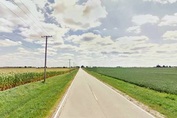
The highway continues south through farmland towards Elwood (marked with a red line in our interactive map). At W. Manhattan Rd., the 1926-30 took a different course into the town that can still be driven. It had four right-angle turns and two grade crossings across the railroad (blue line in our map). It was straightened in 1930.
1926 -30 alignment in Elwood, Illinois
Wilmington
Route 66 ran south and then curved west to go through Wilmington and cross the Des Plaines River (See Wilmington in our interactive map).
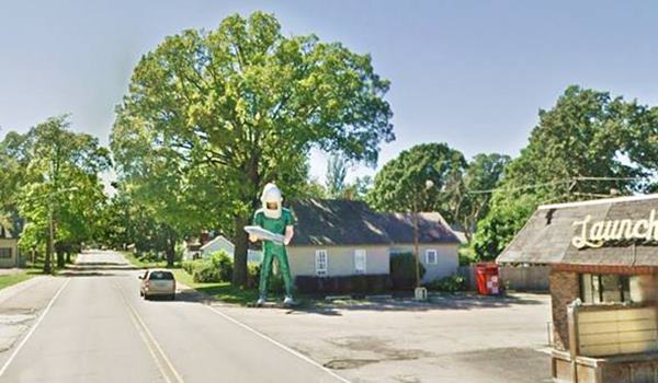
There is a classic wacky attraction here, the "Gemini Giant", one of the many Muffler Men on Route 66:
Wilmington's Gemini Giant
Used to stand on Old Route 66 at 810 East Baltimore St. but it was moved recently to a new locations. The famous Gemini Man is a "Muffler Man", a popular type of roadside advertising eye-catcher from the 1960s. It is a 30 foot-tall (9.2 m) fiberglass statue.
Gemini Giant, viewed close up in Wilmington, Illinois
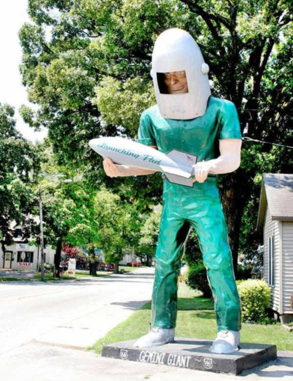
Its name comes from the Gemini Project, a 1960s NASA space program.
See it below and compare its size to the car driving along Route 66.
The Gemini giant from afar, compare size with trees and car!
Braidwood
The highway then took a NE to SW course and ran parallel to the railroad tracks, on their southern side as you can see in our interactive map (green line).
One and a half miles north of Braidwood the new alignment built in 1939 that came from Plainfield, met the tracks and ran on their northern side. They were separate highways, ALT 66 and Main 66, and they were linked at a grade crossing on E Main St. in Braidwood. Both highways continued running parallel to each other into the next town: Godley, but first we will describe the Main 66 alignment from the for, west of Willowbrook, through Plainfield and into Braidwood.
"Main" US 66 (1939-58)

1969 Illinois State Roadmap. Source
Click map to enlarge
The 1939 alignment begins at the fork where Joliet Rd. (1926-39 US66) and IL-126 split. It was aligned along IL-126 with a NE-SW course towards he town of Plainfield (red line in our interactive map).
Plainfield
Here it turned southwards and ran in a straight line towards Braidwood (marked in our custom map with an orange line). The two longest highways in the world at that time, Route 66 and the Lincoln Highway met in Plainfield Illinois.
US 66 1940 to 1958
Route 66 remained aligned through Plainfield until 1958 when US 66 was moved further west to a brand new freeway that bypassed all the towns north of Gardner, including Plainfield. US 66 and I-55 shared the new freeway.
The 1969 state roadmap (click on it to enlarge it) shows I-55 (with US 66) bypass Plainfield, IL-53 has replaced the ALT 66 through Joliet, and further east, Route 66 and I-55 fork when they meet I-294, with US 66 continuing eastwards to the north of I-55.
Alt and Main 66 run side by side
From Braidwood to Gardner, both highways ran with an NE to SW course parallel to the railroad, one on the north side of the tracks, the other on the south side. Our custom map shows both alignments, the Original US66 1926-39, that later became ALT 66 in green, and the Main 66 (1939-58) in blue.
Godley
At Godley there was another link between both highways, at Kankakee Rd.
Braceville
The next town, Braceville also had two grade crossings linking them, one of these was Main St.
Just 0.8 mi. south of the town the alignment of Main 66 has been eliminated on the north side of Mazon river and it is cut off from the alignment which runs north from Gardner because two bridges have been removed and not replaced:

1945 USGS map of Braceville, Il
The USGS Map of 1945 shows how both US 66 and US ALT 66 run past Braceville. The red arrow marks the site of the now gone steel arch bridge.
Mazon River bridges (Gone)
See this Street View looking northwards at the dead end on the south side of Mazon River.
The river was spanned by a steel bridge that was built in 1939. On the north side of the river the highway crossed the railroad that branched off to the north towards Coal City using a steel arch bridge built in 1939 to make travel safer and avoid an existing grade crossing. This bridge was removed in 2001 and is gone; it is pictured below:
The now gone steel arch bridge on Route 66 in Braceville, Illinois
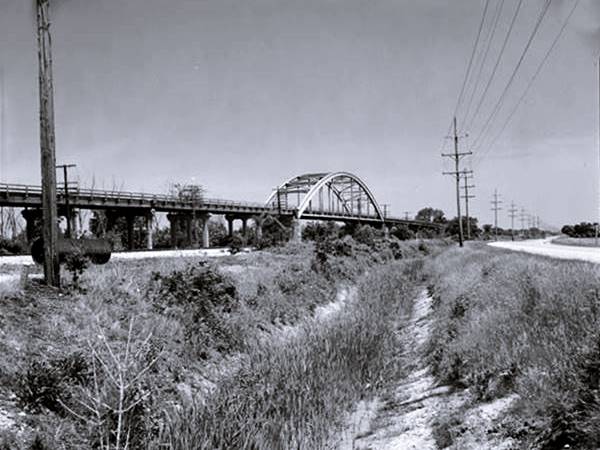
The photo above is captioned: "Distant view to north - Braceville Bridge, Spanning Southern Pacific Railroad tracks at State Route 129 (Old Route 66), Braceville, Grundy County, IL".
The Alternate 66 now I-53 crosses Mazon River on a new bridge built in 1969 that replaced the early 1920s bridge of the original alignment.
Gardner
In 1915 the Pontiac Trail became the main road linking Chicago and St. Louis, but it bypassed Gardner as it went from Joliet to Morris and from there south to Dwight. When State Hwy 4 was built the road was shortened running in a diagonal line from Joliet to Dwight, bypassing Morris and now going through Gardner. In 1939 it became Alt 66 and its course is marked with a green line in our interactive map. As you can see it had two sharp curves and a grade railroad crossing on the south side of town.
When the Main 66 alignment was built, it skirted the town along its western side with a wide curve avoiding grade crossings (blue line in our map).
Dwight
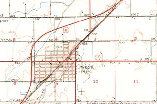
The map below was published in 1924, two years before Route 66 was created. It displays the "Auto Trails" or roads that were suitable for cars. The ones in Dwight are marked with numbers: as "13" and "26" with white numbers inside black squares, these are the "trails" and stood for "Mississippi Valley Highway" and "Blue Grass Road" respectively.
The number "4" inside a white circle is what originally was the Chicago Trail created in 1915 between Chicago and St. Louis. In 1918 the state issued a bond to improve the roads, and the Chicago Trail became SBI 4 (State Bond Issue) highway number 4, as shown in the map.
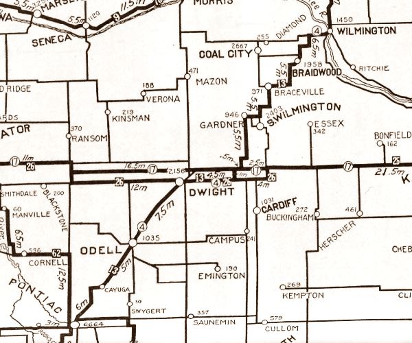
Then, it was realigned and the original 1926 US66 alignment headed with a SW course from Gardner to Dwight until it was decertified in 1977, our map shows its alignment with a burgundy line.
The thumbnail map (click it to enlarge) was published in 1950, at that time I-55 hadn't yet been built (or even planned). You can follow the bypass alignment of Route 66 built in 1944, as it curves around the town, also shown in our custom map, with an orange line.
The outbreak of World War II led to an increase of heavy truck traffic that detriorated the original roadbed. A new and improved alignment was decided upon (Bypass 66). It would be wider, with a stronger roadbed -for the trucks- and would also reduce the traffic congestion in the town, by routing it around Dwight. This road became a four lane alignment with the addition of a second set of lanes in 1954. It remained in use until the freeway, built to modern Intersate highway standards replaced it. It reverted to the state, and as the maintenance costs of a divided four-lane highway were high, it opted to upkeep only two of them, and let the others lie unkpet. You can still see the remains of the abandoned lanes to the west of the present highway (Street View) between the points where I-55 curves around Dwight. North and south of those points these lanes are now buried beneath the current northbound lanes of I-55.
Odell
The highway continues towards Odell, shown with a violet line in our interactive map.
A bypass was also built around the town during WWII (green line).
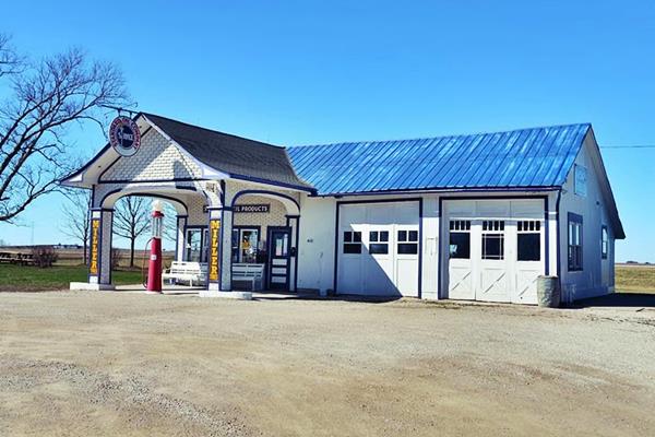
Historic Standard Oil Gasoline Station in Odell, Illinois
Cayuga
South of Odell is the small community of Cayuga. Here you can see the second set of lanes, abandoned, on the west side of the highway. The highway from Odell to Pontiac through Cayuga is marked with a orange line in our interactive map with directions.
Pontiac
This segment reaches Pontiac from the northeast. The remains of US66's former westbound lanes can be seen between Odell and Pontiac.
Continue your road trip following the next segment from Pontiac to Springfield.
Accommodation: Hotels along this leg of your road trip
Chicago and Pontiac have plenty of lodging options for those travelling along Route 66:
> > Book your hotel in Chicago
Find More Accommodation close to Chicago along U.S. 66
Below you will find a list of some of the towns along Route 66 west of this town; click on any of the links to find your accommodation in these towns (shown from east to west):
Along Route 66 in IL
- Hotels in Illinois
- Route 66 Starting point ▸ Chicago
- Lockport
- Willowbrook
- Bolingbrook
- Plainfield
- Romeoville
- Joliet
- Wilmington
- Dwight
- Pontiac
- Chenoa
- Normal
- Bloomington
- Atlanta
- Lincoln
- Springfield
- Raymond
- Litchfield
- Staunton
- Williamson
- Hamel
- Edwardsville
- Collinsville
- Troy
- Glen Carbon
- Pontoon Beach
- Granite City
- East St. Louis
West in Missouri
- Hotels in Missouri
- Florissant MO
- Bridgeton MO
- St. Louis MO
- Kirkwood MO
Continue your Route 66 Road trip:
More Route 66 Alignments
Previous Section
First segment of Route 66.
- This one.
Next Section
Sponsored Content
>> Book your Hotel in Pontiac

Credits
Banner image: Hackberry General Store, Hackberry, California by Perla Eichenblat
Jack DeVere Rittenhouse, (1946). A Guide Book to Highway 66.


