Route 66 in Gardner IL
Index to this page
About Gardner IL
Facts, Information and trivia
Elevation: Elevation 585 ft (178 m). Population 1,348 (2024).
Time zone: Central (CST): UTC minus 6 hours. Summer (DST) CDT (UTC-5).
Gardner is a village in Grundy County, Illinois on Route 66 between Chicago and Pontiac.
History of Gardner
Human beings have been living in Illinois for at least eleven thousand years, when the ice sheets of the last Ice Age retreated. Later, farming groups established themselves along the southwestern part of the state. The northern and central parts of Illinois were peopled during historic times by several Native American tribes: Shawnee, Winnebago, Fox, Miami, Sauk and Potawatomi, Kickapoo, and Illinois.
The French explored the Illinois River in 1673, and incorporated it into their territory of Louisiana. In 1763 it was annexed by the English after defeating the French in the Seven Years' War. During American Independence war, it became the North west Territory (1783) which was organized in 1809. Its first capital was established in the south, on the Mississippi, in Kaskaskia.
It became part of the Union in 1818, as the 21st state, and it banned slavery. The state capital moved to Vandalia in 1819 and finally (backed by the then state representative Abraham Lincoln) to Springfield in 1837.
Although some settlers were already living in the 1820s and 30s in what would become Grundy County, they were few.
Grundy County was created in 1841 and it was named for US Attorney General Felix Grundy (1777 - 1840). The area was known for having coal, and the first economic activity in the area was coal mining.
Like most towns on Route 66 in Illinois, it was the Chicago & Alton Railroad that led to the establishment of the town: a railway chief engineer, Henry Gardner and his partners J.C. Spencer, and C.H. Gould had bought the land knowing the course that the tracks would take. They platted a town in 1854 and named it after Gardner.
The name: Gardner
It was named after Henry Gardner, the founder of the town. The surname Gardner comes from the Old French word "gardinier" and taken to England during the Norman Conquest in 1066 AD. It is a person who worked as a gardener.
It incorporated in 1867. A fire razed the business district in 1878, and it was rebuilt. The town prospered mining coal. Route 66 was created in 1926 and it passed through Gardner.

Hotels and Motels in Gardner
There are several hotels close to Gardner and in the neighboring towns along Route66.
>> Book your Hotel in neighboring Wilmington or Dwight
Find More Accommodation near Gardner along Route 66
Below you will find a list of some of the towns along Route 66 east and west of this town; click on any of the links to find your accommodation in these towns (shown from east to west):
Along Route 66 in IL
- Hotels in Illinois
- Route 66 Starting point ▸ Chicago
- Lockport
- Willowbrook
- Bolingbrook
- Plainfield
- Romeoville
- Joliet
- Wilmington
- Dwight
- Pontiac
- Chenoa
- Normal
- Bloomington
- Atlanta
- Lincoln
- Springfield
- Raymond
- Litchfield
- Staunton
- Williamson
- Hamel
- Edwardsville
- Collinsville
- Troy
- Glen Carbon
- Pontoon Beach
- Granite City
- East St. Louis
West in Missouri
- Hotels in Missouri
- Florissant MO
- Bridgeton MO
- St. Louis MO
- Kirkwood MO
>> See the RV campground nearby in Braidwood and also in Joliet
The Weather in Gardner
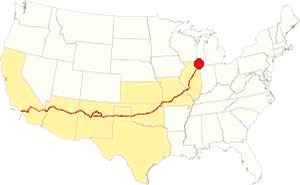
Map showing the location of Gardner, Illinois on U.S. 66
The climate of Gardner is a humid continental one with all four seasons distinctly represented; summers are hot and humid, spring is wet and cool, fall is mild and quite pleasant, but winters are rather cold.
Temperatures: The average winter (January) high is 31°F (-0.3°C); and the average low is 17°F (-8.6°C). The summer average high (July) is 84°F (29°C) and the average low is 64°F (17.7°C).
Rainfall ranges from 3 to 4.3 (78 and 110 mm) inch monthly from April to November, and falls to a drier 1.7 in. (28 mm) the rest of the year. On average, Gardner gets 36.82 inches of rain each year (936 mm).
Snowfall: on average, 28 inches (71 cm) of snow falls each year. The first snow falls in Nov. and the last (less than 1⁄4 inch or 8 mm) falls in April. There is usually no snow between May and September.
Tornado risk
Grundy county, where Gardner is located gets around 6 tornado strikes per year.
Tornado Risk: read more about Tornado Risk on US 66.
Map of Route 66 in Gardner, IL
>> Our Custom map shows the alignments of U.S. 66 in Gardner.
The map below was published in 1924, two years before Route 66 was created. It displays the "Auto Trails" or roads that were suitable for cars. The ones near Gardner are marked with numbers: as "13" and "26" with white numbers inside black squares, these are the "trails", standing for "Mississippi Valley Highway" and "Blue Grass Road" respectively.
The number "4" inside a white circle is what originally was the Pontiac Trail created in 1915 between Chicago and St. Louis. In 1918 the state issued a bond to improve the roads, and the Pontiac Trail became SBI 4 (State Bond Issue) highway number 4, as shown in the map. Notice its zigzag course that was straightened out before it was paved.
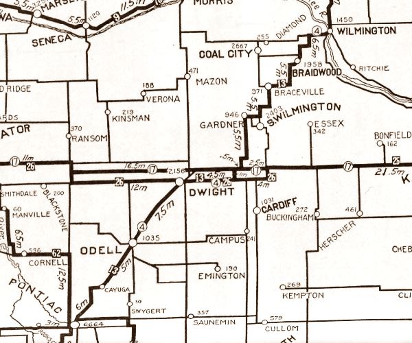
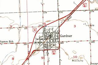
The thumbnail map (click it to enlarge) was published in 1948, at that time I-55 hadn't yet been built (or even planned).
The State Hwy 4 was completely paved by 1923. Route 66, when it was created in 1926, shared its alignment.
Route 66's three alignments in Gardner
US 66 from 1926 to 1929
The original alignment went through the downtown of Gardner red line in our custom map.
US 66 in the 1930s
In 1930 the highway was realigned, bypassing the town along its eastern flank as shown with a green line in our custom map. East of Gardner, the highway remained unchanged from 1926 to 1939 and ran along the eastern side of the railroad with a NE-SW course all the way from Wilmington, passing through Braceville, Godley and Braidwood.
US 66 from 1940 to 1977
By the late 1930s, a straighter and quicker alignment was necessary, and it was built through Plainfield (north of Gardner) and had a lineal course north to south all the way to the railroad south of Wilmington (yellow line in our custom map). Here after meeting the tracks it turned to the SE and ran along the western side of the railroad parallel to it, and to the older alignment. This is marked with a blue line in our custom map.
The "new" highway from Plainsfield to Gardner became Route 66; it also included a "Bypass" alignment that skirted Gardner along its western side.
ALT US 66 1940 to 1967
The 1926 alignment from Gardner, Braidwood all the way to Romeoville through Joliet became ALT US 66 and remained so until 1966. The Alternate 66 alignment was eliminated in February 1967 and replaced by Illinois State Highway 53 from Welco Corners to Gardner.1
US 66 from 1958 to 1977
In 1958 US 66 was moved to a new alignment which it shared with the new freeway (I-55) it absorbed part of the old US 66 between Plainfield and Blodgett, but bypassed the old segment from there until Gardner (leaving Braidwood, Godley and Braceville on ALT 66). violet line in our custom map.
Alternate US 66
The American Association of State Highway and Transportation Officials (AASHTO) created the "Alternate" designation in 1959. Its purpose was to designate a route that branches off from the main highway, passes through given towns or cities and then connects again with the main numbered route. The idea is to accommodate a high traffic demand.
When the Alternate and Main highways followed a similar course, the shorter and better built highway would be marked as main and the other as alternate.
There are only six places along Route 66 where an Alternate 66 alignment existed: From East to West they were this one close on Route 66 into Chicago, Carthage MO, the one in Joplin MO, Oklahoma City, Alt 66 in San Bernardino, California, and the one leading into Los Angeles CA.
Route 66 is a Historic highway and has also been designated as a National Scenic Byway and an All-American Road in the state of Illinois.
The Route 66 alignments near Gardner
Description and interactive maps of US 66.
- Pontiac to Springfield (next)
- Chicago to Pontiac (Gardner's)

Gardner's Route 66 Landmarks and Attractions
What to see in Gardner
US 66 in Gardner: historic context
In 1946, after driving all the way from Chicago to Los Angeles along Route 66, Jack DeVere Rittenhouse published his classic "A Guide Book to Highway 66". His entry for Gardner is the following:
Gardner lies to the east of US 66 here. There are gas stations and a cafe on US 66 at this intersection... Rittenhouse (1946)
He adds that it is now a farming community and his remark that the town was to the east means that he drove down the main US 66 and not ALT 66 around it.
Your US 66 Road Trip in Gardner
Drive from north to south, coming from Braceville along the 1926-39 US 66 (Later ALT 66), this will help you avoid the cut-off segment on the later U.S. 66 alignment due to the removal of a bridge on it. The former U.S. 66 is now IL-129.
ALT 66 to the east of the abandoned alignment is now IL-53 and runs westwards to Gardner.
Mazon River bridge (Gone)
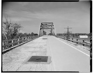
On the Mazon River bridge, US 66. Source. Click to enlarge. view
The former US 66 (1939-57) ends just north of the Mazon river, cut off because its bridge has been removed. The black and white image above (click to enlarge) shows the roadway of US 66 crossing the bridge.
Mazon river was spanned by US 66 using a steel arch bridge that was built in 1939; it continued on the north side of the river to carry the highway across a fork in the railroad that branched off to the north towards Coal City. This bridge was removed in 2001 and is gone; it is pictured below, seen from ALT 66.
The now gone steel arch bridge on Route 66 in Braceville, Illinois
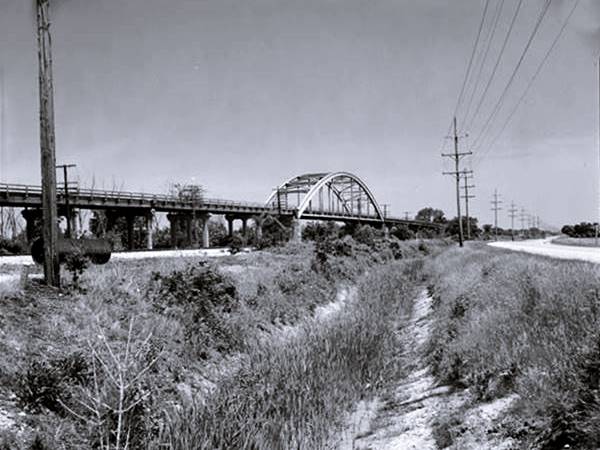
The photo above is captioned: "Distant view to north - Braceville Bridge, Spanning Southern Pacific Railroad tracks at State Route 129 (Old Route 66), Braceville, Grundy County, IL." Further up is the view of the same spot nowadays, with the same curve in the highway, but without the bridge.
The original alignment on the south side of the tracks wasn't modified in the 1930s, and as Alternate 66 it crossed Mazon River on a new bridge built in 1969 that replaced the early 1920s bridge of the original alignment.
Site of the Riviera Restaurant (Gone)
To your left, after crossing the Mazon river bridge at 5650 Route 53. There is a sign at the small marker at the site, pictured below.
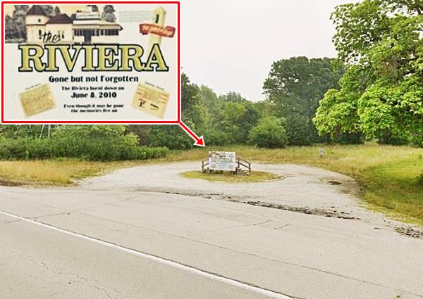
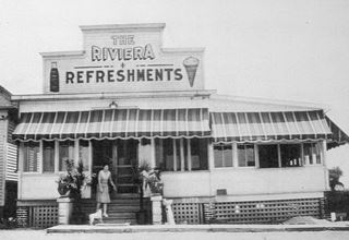
James C. Girot, an Italian immigrant and former coal miner built the woodframe building that would become the Riviera in 1928, he put together several buildings, a local church and a former mining office building from South Wilmington was joined up to make it. A few years later (1932) a streetcar was added to the complex.
Jim, his wife Rose Laura (Bolatto) and their children Irene, Violet Catherine, Larry, and Lillian moved there in 1928. In his 1930 census entry he states he is the proprietor of a delicatessen.
During the Prohibition days of the 1930s liquor flowed in the basement, which was decorated as a cave. There was also illegal gambling in the place that was said to be frequented by Al Capone.
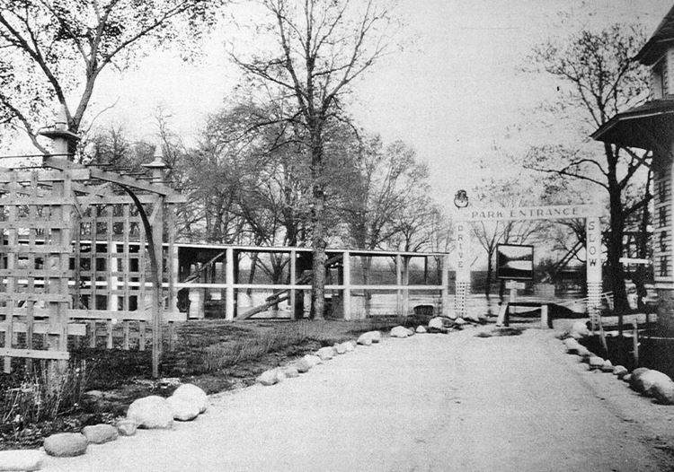
The images below show it in the 1930s, the first is the main building, the second looks north, towards the river, where the entrance to the Park was located.
Gene Kelly and Tom Mix were also among its patrons. Eventually it had a "zoo" and a gas station. But a fire razed the place in 2010. It is now, sadly gone. A s
From 1929 to 1972 it was operated by the Girot family. In 1972 "Bowtie Bob" Kraft and his wife Peggy took over. They ran it until they sold it and retired in 2009. It was inducted into the Illinois Route 66 Hall of Fame in 1994. Below is an aerial view taken in 1975, and the blaze that razed it in 2010.
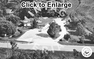
The Riviera 1975 aerial view. Source. Click to enlarge
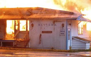
The Riviera burning down, 2010 Source
This is a 2008 street view while it was still standing.
The fire caused a total loss, and the Kelly's donated the streetcar that lay on the back part of their property to the city of Gardiner, and it is now restored and located in downtown Gardner as the Historic Streetcar Diner.
Continue your drive into Gardner. To the west, beyond the railroad tracks is the now abandoned 1940-1958 Route 66 alignment; after 1.3 miles the highway curves away from its NE-SW course, leaving the tracks and runs with a north-south alignment. This is the northeastern side of Gardiner. Just ahead is the fork where the 1926-30 alignment turns into Gardiner along E Washington Street. There is a brown and white "Historic Route 66" sign marking the way into town. The 1930-39 US 66 ⁄ 1940-67 Alt 66 alignment continues straight and runs around the town's eastern and southern sides; there are no landmarks along this later alignment.
1926-30 US 66 in Gardner
Here at the crossroads by 1932 there were two gas stations, one on each side of E Washington St. The 1932 Sanborn map of Gardner shows both of them.
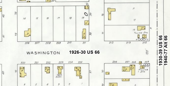
1932 Sanborn map, Gardner (detail). Source. Click to enlarge
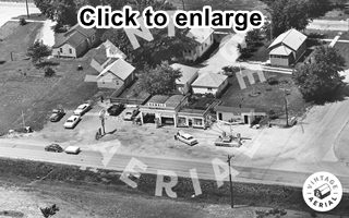
1968 Humble station, aerial photo. Gardner. Source. Click to enlarge
The gas stations' buildings have survived but no longer operate as such.
Former Gas Station
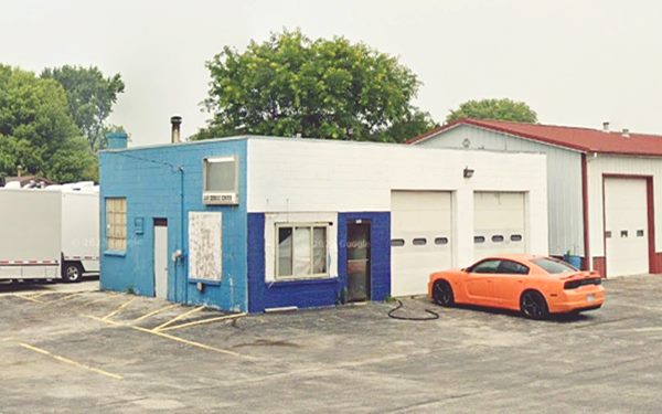
401 IL-53, on the NW corner, to your right as you turn onto Washington. A two bay garage, box shaped gas station from the 1930s with a corner office. Built with concrete blocks no pump islands or canopy.. Now it is J amp; R a repair shop.
Former Gas Station in Gardner, Illinois
Former Humble station
Across Washington St. on the SW corner was another gas station that can be seen in the picture furhter up. It was a Humble Enco station in 1965, and this street view shows its current appearance.
The original alignment zigzagged across the town, it ran along E Washington St. for 3 blocks and by the tracks, turned south along N Center St. Signs mark the way. Here on the curve, to your right is a "modern" Route 66 stop.
The Shop On Route 66
A modern-era tourist attraction at 315 N Center St. is the red gable-roofed building that houses Perkins Wood and Glass, also known as "The Shop".
It is ideal for a photo opportunity, with Route 66 shields and a great collection of Coca-Cola memorabilia and U.S. 66 stuff, including some large-sized shields.
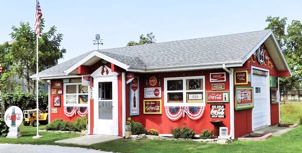
Route 66 curves slightly to the right along Depot St. running parallel to the railroad. The sign by the Shop indicates that the town's Jail is just ahead along N. Center St. Drive south one block to the SE corner of N Center and Mazon streets to visit them.
Historic two-cell Jail
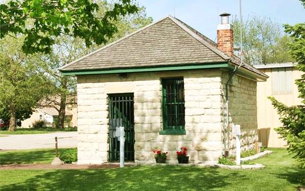
Built in 1906, it housed criminals until 1950. It is a small building, made of hewn stone that has two cells on one side, and a small section for the guard with a desk and a stove on the other.
The jail cells are separated by a sheet of steel and the bars face the guard section. The only ammenities in the two cells were a bucket (as a toilet) and a cot.
Gardner's two-celled jail
Christian Christiansen Memorial
Next to the Jail there is a memorial with a plaque that explains this man's actions that saved millions of lives.
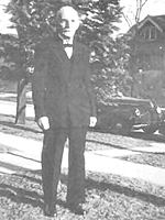
Christian Christensen. Source
Christian Christiansen (1859 - 1947). Born in Sandnes Norway, he became a sailor and eventually immigrated to the US in 1880, he was ordained as a minister in 1888 and settled in Gardner Illinois as a pastor. During World War II he read a newspaper article about the Nazi Germany's heavy water plant in his Norwegian hometown, which was inexpugnable. But the Reverend knew the fjord and the mountains so he contacted the U.S. Navy and shared his knowledge with Naval Intelligence.
The allies organized a raid, conducted by the British military in Feb. 1943 (Operation Gunnerside) destroying the facilities and preventing the Nazis from building an atomic bomb. The King of Norway acknowledged his actions with a letter.
Christiansen had saved millions of lives. The movie "Herors of Telemark" (1965) starring Kirk Douglas tells the story of the commando raid.
The memorial has is photograph and facsimiles of letters celebrating his cooperation.
Historic Streetcar Diner
Route 66 Hall of Fame
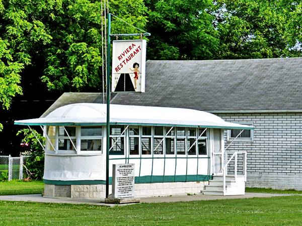
On the same spot, just south of the jail, is a former Kankakee streetcar that at one time stood at The Riviera. Next to it is the "Betty Boop" sign from the Riviera Restaurant, both structures survived the fire that razed the old roadhouse and were donated by its last owners to the city.
Kankakee is a town about 40 miles east of Gardner. The Kankakee Electric Railway Co. began operating a streetcar service in 1891. By the early 1900s, there were two other companies linking the town with Chicago. But the automobile and buses competed with the streetcars causing it to stop operating in 1931. A bus service raplaced it in 1932 (it finally ceased operations in 1960). They sold their old streetcars and one was moved to Gardner where it was a diner by the Greyhound bus stop from 1932 to 1939.
It was moved behind the Riviera in 1955 and was restored the Route 66 Association of Illinois while it was there; it was also inducted into the Route 66 Hall of Fame in 2001.
The Streetcar at its original location at The Riviera (before the fire)
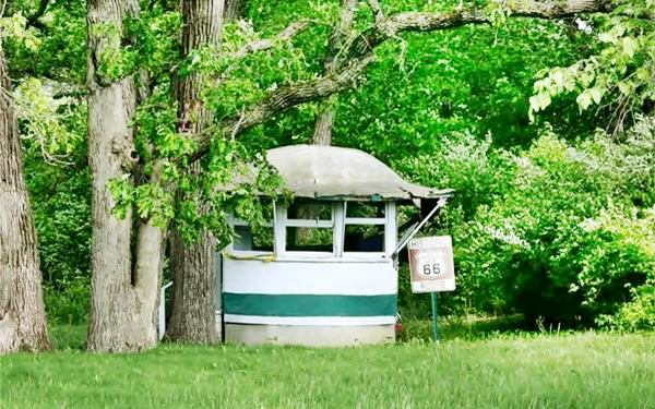
After the fire it remained at the site next to Mazon River, and later it was moved to its present location in downtown Gardner. There is a white marble marker beside it that reads:
In Appreciation
Thank you to Bob and Peggy Kraft for donting this Route 66 Hall of Fame streetcar to Gardner.
The Krafts provided years of food, fun and nostalgia at their Riviera roadhouse Located on Route 66. The Riviera unfortunately burned down on June 8, 2010.
It is the town's desire that this piece of Gardner history will provide fond memories to all who visit
The Streetcar nowadays, in downtown Gardner
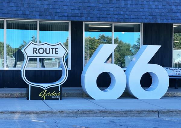
Gardner Route 66 Community Monument
Head back to Depot. St. to visit this modern attraction. The marker is another good spot for a Route 66 photo op. It is one of many along the Mother Road sponsored by the Heritage Corridor Bueau using a $1.5 million grant from IL DCEO designed to enhance sites along Route 66 ahead of the Route 66 Centennial (1926-2026). You can find them in Joliet, Burr Ridge, Willowbrook, Romeoville, Lockport, Gardner, Dwight, Pontiac, Bolingbrook, Countryside, and Plainfield.
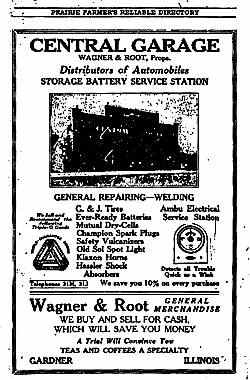
Wagner & Root's Central Garage. Source
In 1917, Wagner & Root who were dealers in confectionery and groceries, also owned the Central Garage here in Gardner, they sold tires, batteries, and spare parts. In the early 1900s there were several businesses in town catering to cars and trucks: Peter C. Hansen was the "proprietor of an automobile livery", J.P. Kennedy, proprietor of a garage, Fay LaCore, an automobile repairer. The building pictured in the advertisement looks very much like Hansen's at 203 Liberty St. across the tracks (street view).
Southeastern Gardner
Route 66 turned sharply right along E Jefferson St., and then sharply south (left) at the tracks along S Jackson St. Five blocks south it turned west (right) along E Parker St. This is where it meets the later alignment that curves around the eastern and southern sides of town. At one time there was a filling station on the NW corner of Jackson and Parker, and two gas stations facing each other between S Grundy and S East St. This roadway carried Route 66 from 1926 to 1944 and then it carried Alt 66 until 1967.
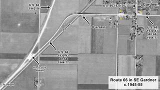
1945-55 aerial view SE Gardner (details in the text). Source
The image (click on it to enlarge it) shows the alignment on the southeastern side of Garner. The yellow stars mark gas stations (now gone).
Ahead there is a viaduct on the that crosses over the railroad; the first overpass was built in 1928, eliminating a grade crossing and making the road safer. This viaduct was closed in 1998 and a new bridge replaced it in 2000.
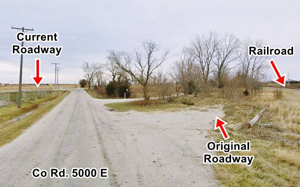
On the western side of the tracks the original alignment followed a different course to the current highway. It curved sharply to the south and ran close to the railroad and across what now is the Illinois DOT station. Much later the alignment was moved to its current course (on the 1944-55 US 66) and the intersection between both alignments was also modified for safety reasons.
But on its southern side, along County Rd 5000 E, on the north side of the IL DOT site, by the railroad you can still see the original alignment fade away into bushes and trees as pictured below.
Looking north along Co. Rd. 5000 E.
South of this point there are no more stops, so turn around and head eastwards along the four-lane US66 (1944-55) and see some spots that catered to those driving along Route 66 at W Main St's junction.
Some Remnants of U.S. 66 in Gardner
There are some spots mentioned by Rittenhouse back in 1946: a gas station on the SE corner of the crossroads, a Standard Service, icebox with plenty of pumps and no canopy (pictured below; click image to enlarge). By 1980, it had become an AMOCO, now it is a U-Haul (street view).
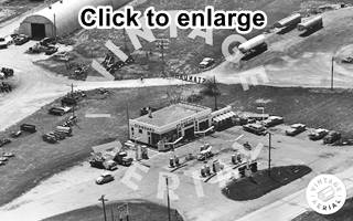
Standard Station 1965 aerial view. Source. Click to enlarge
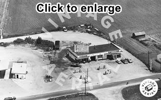
Texacp Station and Restaurant, 1965 aerial view. Source. Click to enlarge
Across Main St., on the NE corner there was a Texaco gas station with four pump islands and a restaurant, perhaps the Cafe mentioned by Rittenhouse. The place is still there, but now it is a restaurant at 425 W Main St. (street view).
Site of Gull Wing Station
Along the later U.S. 66 alignment used after 1956 along what is now I-55 there are no surviving buildings from the golden days, but it is interesting to point out that there was a Gull Wing Phillips 66 station on it; later it sold Texaco branded gasoline (the link shows the image of it in 1980), this is the current Street view of the spot, just 1,000 feet west of I-55's Exit 227 along E Gardner Rd.
> > Learn more about all the Phillips 66 Gull Wing stations on Route 66
Continue your Road Trip
And this marks the End of this leg of your Rote 66 Road Trip in Gardner, head west to visit the next town, neighboring Dwight and continue your adventure!

Sponsored Content
>> Book your Hotel in Chicago

Credits
Banner image: Hackberry General Store, Hackberry, Arizona by Perla Eichenblat
Jack DeVere Rittenhouse, (1946). A Guide Book to Highway 66.


