Route 66 in Cayuga IL
Index to this page
About Cayuga IL
Facts, Information and trivia
Elevation: Elevation 689 ft (210 m). Population est. 150 (2024).
Time zone: Central (CST): UTC minus 6 hours. Summer (DST) CDT (UTC-5).
Cayuga is a small unincorporated community in Livingston County north of Pontiac. On the historic Route 66 alignment.
History of Cayuga
See Pontiac's history for a description of the early history of Livingston county.
Grain Elevator and old railway depot in Cayuga, Illinois
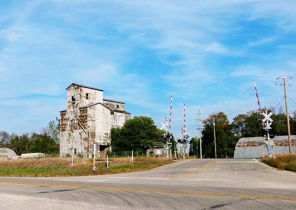
The Chicago & Alton Railroad reached the area in 1853 making it suitable for settlement by farmers. Cayuga was laid out by Thomas F. Norton in 1855, for Corydon Weed. Farmers arrived gradually over the years shipping out their produce by rail.
By 1898 the village of Cayuga had a population of 160, in the 1910s, The "Pontiac Trail" passed by it, as a hard surfaced road that could be used by cars, it was later improved when State Highway 4 was laid along its alignment and paved in the early 1920s. In 1926 Route 66 was created, and it incorporated the former State Hwy. 4's alignment. The town remained on US 66 until it was decertified in 1977, when I-55 bypassed Cayuga.
The Name: Cayuga
Settlers from Cayuga County in New York state reached the area in the 1850s, the word is the name of an Iroquois tribe. The post office opened in 1857.
The Iroquois word Cayuga = "Guyohkohnyo" meant "People of the Great Swamp" and they lived by Cayuga Lake NY.

Hotels and Motels near Cayuga
Accommodation & Lodging close to Cayuga
> > Book your hotel in neighboring Pontiac
Find More Accommodation nearby along Route 66
Below you will find a list of some of the towns along Route 66 east and west of this town; click on any of the links to find your accommodation in these towns (shown from east to west):
Along Route 66 in IL
- Hotels in Illinois
- Route 66 Starting point ▸ Chicago
- Lockport
- Willowbrook
- Bolingbrook
- Plainfield
- Romeoville
- Joliet
- Wilmington
- Dwight
- Pontiac
- Chenoa
- Normal
- Bloomington
- Atlanta
- Lincoln
- Springfield
- Raymond
- Litchfield
- Staunton
- Williamson
- Hamel
- Edwardsville
- Collinsville
- Troy
- Glen Carbon
- Pontoon Beach
- Granite City
- East St. Louis
West in Missouri
- Hotels in Missouri
- Florissant MO
- Bridgeton MO
- St. Louis MO
- Kirkwood MO
>> See the RV campground in Pontiac
The Weather in Cayuga
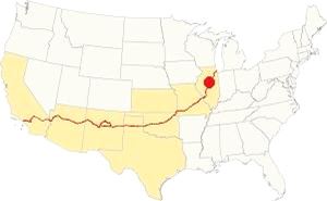
Location of Cayuga on U.S. Hwy. 66
The climate in Cayuga is a "Humid Continental" one, so it has very humid and hot summers and cold winters.
Its average temperatures are the following: during summer (Jul) the high is 85°F (29.7°C) while the low is 63°F (17.2°C). During winter (Jan) the average lows are a freezing 17°F (-8.3 deg;C) while the high is a chilly 30°F (-1 °C).
Rainfall is around 38 in. (965 mm) per year, and the sunny days are, on average 194 days per year. Snowfall is around 26 inches (66 cm) yearly, falling from Nov to the first days of April.
Tornado risk
Livingston county, where Cayuga is located gets around 6 tornado strikes each year. Tornado Risk: read more about Tornado Risk on US 66.
Map of Route 66 through Cayuga, Illinois
Route Alignment
>> orange line in our Custom map shows the alignment of US66 in Cayuga.
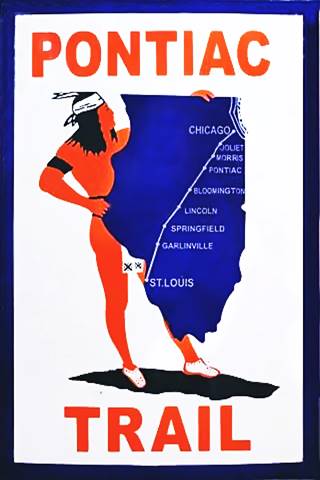
The Pontiac Trail symbol shield
Pontiac Illinois' Route 66
Route 66 reaches Cayuga coming from Odell. The first highway here was the Pontiac Trail that predated U.S. 66 by eleven years.
History: State Highway 4 and the Pontiac Trail
In 1915 the Pontiac Trail became the main road linking Chicago and St. Louis. It had been named after the famous Ottawa Indians chief and B.F. Goodrich marked the milage posts, it even had its own shield sign (see image).
But there was lobbying for the state had to take care of its highways. A bond was issued in 1918 to build decent surfaced roads in the state of Illinois, and the Pontiac Trail was to become the SBI 4 (State Bond Issue) highway number 4.
Federal funds were also provided and the road was paved along its whole length by 1923. It had a winding course, following the railroad and county lanes but it provided a good road between both cities. It passed through Pontiac and the state capital in Springfield.
Route 66 was created in 1926 and it used pre-existing highways as its first alignment; in this area it used State Hwy. 4.
1926-45 two-lane Route 66
The original 1920s road had two lanes 9 feet wide and was 6-inches thick. During WWII it was improved to carry heavy trucks; the two lanes were widened to a width of 24 feet and the concrete was increased to a depth of 10 inches.
Route 66 had become a four-lane divided freeway. You can still see the now abandoned southbound lanes both in Cayuga to the west of the current highway; they are pictured below. Further north, towards Odell these lanes are buried beneath the northbound lanes of I-55.
Route 66 is a Historic highway and has also been designated as a National Scenic Byway and an All-American Road in the state of Illinois.
Visit our pages with old maps and plenty of information about US 66's alignments in this area:
The Route 66 alignments near Cayuga
- Pontiac to Springfield (next)
- Chicago to Pontiac (Cayuga's)

Cayuga's Sights and Route 66 Attractions
What to see in Cayuga
US 66 in Cayuga: historic context
After driving from Chicago to Los Angeles, Jack DeVere Rittenhouse published his "A Guide Book to Highway 66" (1946), and describes Route 66 during its golden days. He has an entry for Cayuga:
A grain elevator, a small school, one store and a dozen homes... no gas station or other facilitiesRittenhouse (1946)
Little has changed since then as we will see below.
Drive US 66 through Cayuga
Drive from east to west, coming from Odell and heading towards Pontiac. Roughly 4.5 mi. west of Odell the freeway curves towards the west. The former westbound lanes of the 4-lane U.S. 66 alignment reappear (until this point they have been buried by I-55's EB lanes).
Wolf Creek Bridge
Just half a mile west the highway reaches North Wolf Creek. Here the span of the WB lanes bridge built around 1955 is gone. The current bridge on Route 66 was rebuilt in 1998 and originally built in 1955.
Meramec Caverns Barn in Cayuga
66 Roadside Attraction
As you pass the bridge, there is an access to the "old" set of lanes and a parking spot on them, to your right. Stop and see the Meramec Caverns Barn.
North side of Cayuga between I-55 and US 66, 600 feet west of the highway.
The Meramec Caverns Barn also known as the Cayuga Barn is a survivor from bygone days. It is a barn that had been painted with an 1930's advertising of the famous "Meramec Caverns" located on Route 66 in Stanton Missouri.
It was restored and repainted by the Route 66 Association of Illinois Preservation Committee, and you can see it safely from the pull-off area located on the old highway.
This is the Exact location of the barn.
Meramec Cavern Barn in Cayuga, Illinois
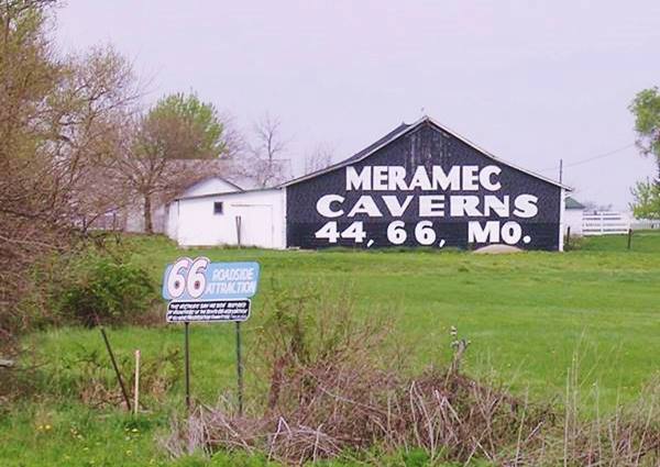
Barn advertising
There were more barns along Route 66 though few have survived: Lexington IL, Hamel IL, Conway MO, St. Clair MO, Phillipsburg MO and Chandler OK.
The Meramec Caverns are also located on on Route 66, in Stanton, Missuouri, and are also known as "Missouri's Buried Treasure." The caves are the largest cave complex West of the Mississippi. The caverns system was discovered in 1720 by French explorer Philipp Renault and used for many purposes over time.
In the 1890s it was a dance venue, but it became famous when Lester Dill (1898 - 1980) bought it in 1933 and turned it into a tourist attraction. Dill already operated Fisher's Cave in Meramec State Park, so Dill renamed the caverns as the "Meramec Caverns".
Dill promoted his tourist attraction using bumper stickers and also by paying farmers so that they painted the words "Meramec Caverns" on barn roofs all across the region. His painted barns covered 14 states. Few have made it into the twenty first century, this is one of them.
Historic Route 66, Cayuga to Chenoa (1943-44 ⁄ 1954-55)
Listed in the National Register of Historic Places
As mentioned further up, the wartime truck traffic damaged the original 1920s road's concrete that was 6-inches thick.
So during 1943-44 the highway was upgraded and widened to 24 feet with 10-inch thick concrete. The first set of lanes of the 4-lane highway were finished by 1944 and built over the older paving. The second set of northbound lanes were finished by 1955. A central median separated them. The former southbound lanes have retained their original concrete surface.
Cayuga
Grain elevator
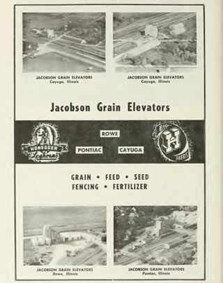
1955 ad of Jacbson Grain Elevators. Source. Click image to enlarge
The highway climbs a slight hill, to your left, on the eastern side of the tracks is the grain elevator mentioned by Rittenhouse.
Cayuga's farms produced grains and they were stockpiled in the grain elevator and shipped out by rail. In 1897 the grain shipments were 150,000 bushels of corn and 100,000 bushels of oats. The owners of the grain elevators in 1898 were The Middle Division Elevator Co. with W. A. Worth, Manager. In 1921 the Pontiac Farmers' Grain Co. operated the elevator and in 1955 they were operated by Jacobson Grain Elevators.
The corrugated metal elevaor is flanked by other storage areas built like Quonset huts.
Old Railway Depot
Drive on and just ahead, to your left is the town's grain elevator, on the eastern side of the railroad. At its foot is the abadndoned Old Railway Depot slowly decaying and falling apart (E 2160 N Rd. and railroad tracks).
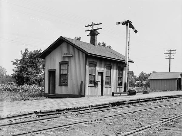
The old railway station, which you can see below in a photograph from ca. 1905 has been moved from its original position next to the tracks, and placed under the grain elevators.
Present appearance of the old Depot in Cayuga, Illinois
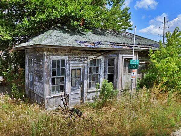
The old railroad depot, in 1905 is pictured belo; at some time its gable roof was changed for a hip roof.
Old Depot in a 1905 photo in Cayuga, Illinois
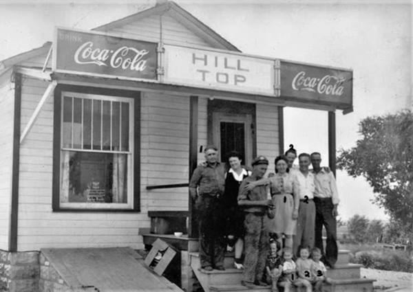
On the opposite side of Route 66, on the SW corner of 2170 N Rd. and Route 66 beyond the old abandoned set of lanes was a classic Route 66 Cafe. Gone long ago.
Hill Top Café (gone)
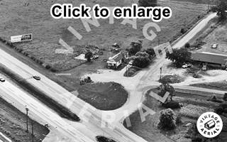
1972 aerial view of Hill Top Cafe and US 66. Source. Click image to enlarge
The Cafe was a small woodframe building with a gable roof. It can be seen (upper left side of the crossroads) in the 1972 aerial photo.
Joy Anna (Garlock) Henderson and her husband Archie Wilbur Henderson (1928-1985) ran the Cafe in from 1963 to 1965, at that time they also owned Archie's Standard Service in Pontiac (from 1956 to 1963). Joy was inducted into the Illinois Route 66 Hall of Fame in 2007 for both Archie's and theis "Mom & Pop" Café. Below is an older picture of the spot.
Continue your Route 66 Road Trip
This ends your drive through Cayuga, head west to visit Pontiac and its U.S. 66 landmarks. We also dedicated a special webpage on the famous Pontiac Murals with a tour of downtown Pontiac.

Sponsored Content
>> Book your Hotel in Chicago

Credits
Banner image: Hackberry General Store, Hackberry, Arizona by Perla Eichenblat
Jack DeVere Rittenhouse, (1946). A Guide Book to Highway 66.

