Index to this page
Pontiac to Springfield IL, itinerary and alignment
Illinois Route 66 Itinerary and maps
Each leg of Route 66 described below has an interactive map and many image maps so you can follow the alignments of the highway along the way:
- Chicago to Pontiac - Map of this segment.
- This leg: Pontiac to Springfield - Map of this segment.
- Springfield to Staunton (1926-30) - Map of this segment.
- Springfield to Hamel (1930-1977) - Map of this segment.
- Hamel to St. Louis - Map of this segment.
Missouri, next leg
Pontiac to Springfield along Route 66
 >
>
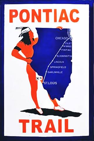
The Pontiac Trail symbol shield
Pontiac Illinois' Route 66
This leg of Route 66 begins in the city of Pontiac IL. Route 66 reaches the town coming from Cayuga, on the Chicaco to Pontiac (1st leg of US66)
There have been several alignments of the highway across the town, the first was the Pontiac Trail that predated US66 by eleven years.
History: State Highway 4 and the Pontiac Trail
In 1915 the Pontiac Trail became the main road linking Chicago and St. Louis. It had been named after the famous Ottawa Indians chief and B.F. Goodrich marked the milage posts, it even had its own shield sign (see image).
But there was lobbying for the state had to take care of its highways. A bond was issued in 1918 to build decent surfaced roads in the state of Illinois, and the Pontiac Trail was to become the SBI 4 (State Bond Issue) highway number 4.
Federal funds were also provided and the road was paved along its whole length by 1923. It had a winding course, following the railroad and county lanes but it provided a good road between both cities. It passed through Pontiac and the state capital in Springfield.
Route 66 was created in 1926 and it used pre-existing highways as its first alignment; in this area it used State Hwy. 4.
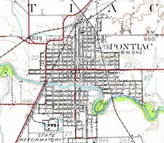
1935 USGS map (See the winding path of Route 66 in red diagonally across the map), Pontiac, Il.
Click thumbnail map to enlarge
1926-45 two-lane Route 66
The original 1920s road had two lanes 9 feet wide and was 6-inches thick. During WWII it was improved to carry heavy trucks; the two lanes were widened to a width of 24 feet and the concrete was increased to a depth of 10 inches.
We begin our journey on the north side of town, just before the crossroads of N 1600 E Rd. there is a gap in the alignment. This was the original 1920s State Hwy 4. When US66 was rerouted around Pontiac in 1945 (current Old Route 66) this segment was eliminated (yellow line in custom map).
It had a winding course with three right angle curves (red line in the 1935 map - click on it to enlarge) and ran on the west side of town; it is marked with a pale blue line in our interactive map.
Division Street Bridge
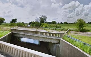
The bridge was built in 1926 and spans North Creek. This is a Location map.
The original bridge was rebuilt in 2005 and is only 33 feet long. It's bridge end had the highway marking stencilled on it as was the practice in those days to mark highways. And the original image survived; it was restored in 1927 and you can see it on the brige end, an outline of the state of Illinois with a number 4 inside of it. The original bridge ends were kept and attached to the new bridge which was built with a railing that is identical to that of the original bridge.
The highway curves as it reaches Vermillion river and heads towards the SW. Nowadays its southern tip is cut off from the original alignment. This gap dates back to the building of the 1945 four-lane bypass highway. The gap is shown with a Pink line in our custom map.
Historic Route 66, Cayuga to Chenoa, through Pontiac (1943-44 ⁄ 1954-55)
Listed in the National Register of Historic Places
The original road was severely deteriorated by the trucks during WWII so it had to be urgently improved. The highway was rerouted around Pontiac adopting a curved bypass alignment (see the pale blue line to the left). A second set of lanes was added to the original alignment north and south of Pontiac that became the northbound lanes of the 4-lane divided highway. These were completed in 1954-55.
Route 66 had become a four-lane divided freeway. You can still see the now abandoned southbound lanes both north and south of Pontiac, to the west of the current highway; they are pictured below. Further north and south, these lanes are buried beneath the northbound lanes of I-55.
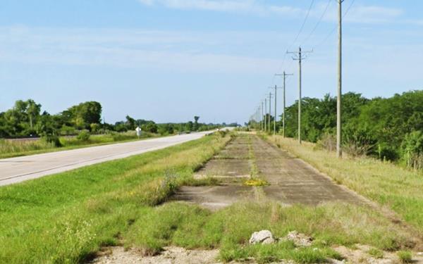
To Ocoya and Chenoa
The higwhay continues southwards from Pontiac, it goes past Ocoya flanked by the abandoned set of lanes, it passes by the historic 1940 bridge (pictured) and reaches the north side of Chenoa. It followed alignment shown in this map with directions from Pontiac to Chenoa; the 1921-44 alignment into Chenoa along Morehead St. and then continued south along a now abandoned segment shown with a purple line in our custom map. Its southern tip is pictured further down.
In 1943-44 a bypass with 4-lanes was planned and built, west of the Chenoa's business district to make the highway safer and faster, it was finished in 1954 (see the green line in our map). Shortly after, in 1958, the new I-55 bypassed the 4-lane '66.

From Chenoa to Lexington
The original highway runs with a NE-SW course to Lexington, its former southbound lanes are now buried beneath I-55s northbound lanes, the blue line in our map shows the alignment all the way to "Memory Lane".
Route 66 Memory Lane
Route 66 Attraction
To your left, at Parade Rd. and Historic Route 66. This stretch of road roughly one-mile long is the original 1926 roadbed that was used until the four-lane divided higway was built just west of it, to skirt Lexington. The highway has been restored and has some vintage billboards. See this custom map of US66 1926-40s in Lexington (pale blue line right side).
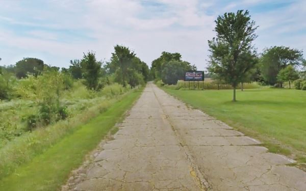
1940s - 1977 Route 66 in Lexington
The two lane road became damaged with use and the heavy traffic during WWII required urgent improvement so a completely new four-lane alignment was built around the town; see the orange line in our custom map.
From Lexington to Towanda
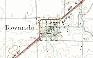
The 1926 to 1977 Route 66 continues with its SW course towards Towanda, with the former Southbound lanes of the 4-lane US 66 built after 1945 visible until I-55 approaches the road. Then they are overlaid by the freeway's Northbound lanes almost all the way to Towanda. The alignment is marked with a red line in our custom map. That also shows the final part, in Towanda that is cut by I-55 twice and has the infamous Dead Mans Curve a right angle turn on the west side of town. There were several of these curves on the original Route 66 that were built when highway construction was new and they made Route 66 dangerous (Bloody 66).
On the south side of Towanda there is a gap in the alignment, after the tip of S Quincy St.
Like Cheona, Lexington and Pontiac, in 1945, a bypass highway was built around Towanda to eliminate the sharp curves and add a set of lanes to the highway, see the gray line in our custom map.
Normal
The road kept a NE-SW course (orange line in our custom map) until it reached the outskirts of Normal where it turned west along Pine St. and had three right angle curves across the town to continue south together with State Hwy 2, later US 51 into Bloomington.
Bloomington
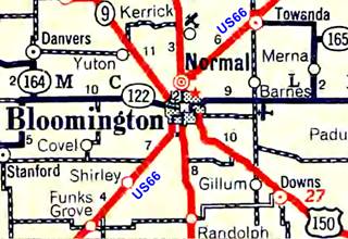
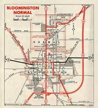
1936 IL DOT map of Normal and Bloomington, IL. Source
Click thumbnail map to enlarge
The original alignment ran along Main Street from Normal to Bloomington. The split into north and southbound traffic (now I 55 Bus.) along Main and N and S East streets (northbound) and S and N Center and Madison streets (southbound) only took place much later, in the 1960s. The block between Olive and Front was also open to traffic in those days. See the 1952 Sanborn map showing the original street layout.
As you can see in the 1936 map (click on it to enlarge it), U.S. 51 ran across the town from North to South along Main, and Route 66 left the town westwards after crossing the railroad by Bloomington's Depot, following W Oakland Ave, and then it turned south along S. Morris Ave (see the right angle turn marked with the black lines by the "n" of "Bloomington".) Also see this 1937-47 aerial photograph.
The 1926-38 Alignment out of downtown Bloomington is marked with a red line. The alignment from Normal to Downtown and the post-1938 City 66 is shown in our custom map violet line.
Bypass 66
By 1938 it had been decided to build a bypass alignment along the eastern side of Normal and neighboring Bloomington; marked with a white line in our map it began in 1939 and was finished in 1945. There is a gap at its SW tip in Bloomington, at the exchange between I-55 and I-74 The original road became "City 66" as you can see in the 1955 map (click on it to enlarge).
Southwest towards Shirley
The highway continues with a SW course into Shirley. During the late 1940s it was upgraded with the addition of a second set of northbound lanes. These were later removed when I-55 was built in the late 50's and they lie under the southboun lanes of the freeway. Only the former westbound lanes of US 66 have survived.
See the pink line in our map
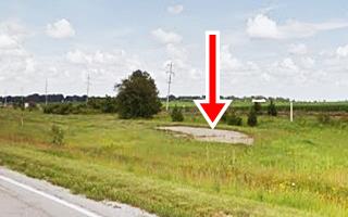
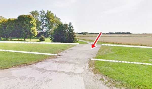
At Shirley the two northbound lanes are now beneath the "Constitution Trail" for joggers and bike fans. North of Shirley you can see a very small segment of these two lanes as shown in the image below where the eastbound lanes are now under the grass both left and right of the concrete strip now used as part of a road that heads transversal to the US 66 alignment. The dashed line marks the former alignment.
Funks Grove
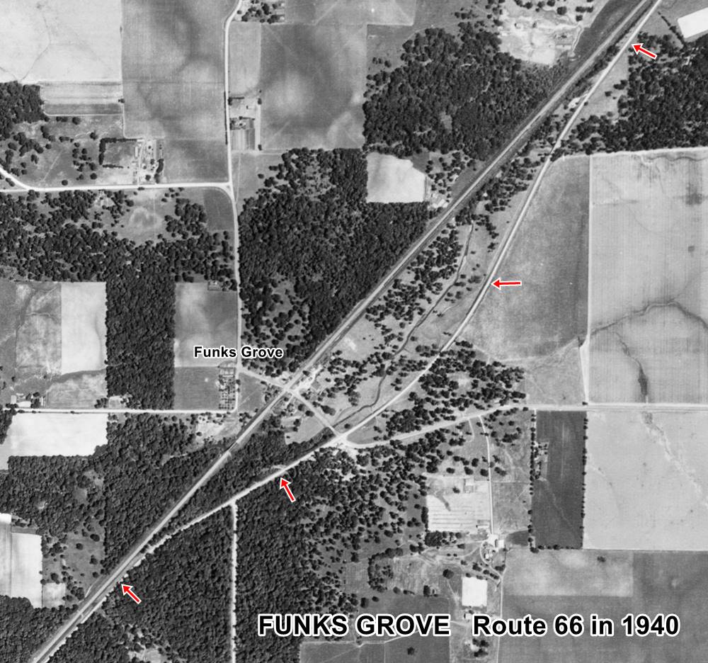
1940 aerial photo Funks Grove IL. Source
Click thumbnail map to enlarge
The road continues towards Funks Grove, where the original State highway #4 and the original 1926 Route 66 alignment ran along a now partly closed alignment that curved eastwards from the current straight alignment; it can be seen (red arrows) in the thumbnail image (click on it to enlarge), that shows a 1940 aerial view of the area. We also marked it with a yellow line in our custom map. The northern part of the roadbed is still there hidden in the forest as you can see in this satellite view. A better image of the original alignment can be seen in this 1970 aerial photo, as an arched segment to the left of the current alignment.
This curved segment was eliminated in 1946. The image below by Gerald Allan Sohl looks northwards along Route 66 under construction. The original alignment can be seen curving to the right.
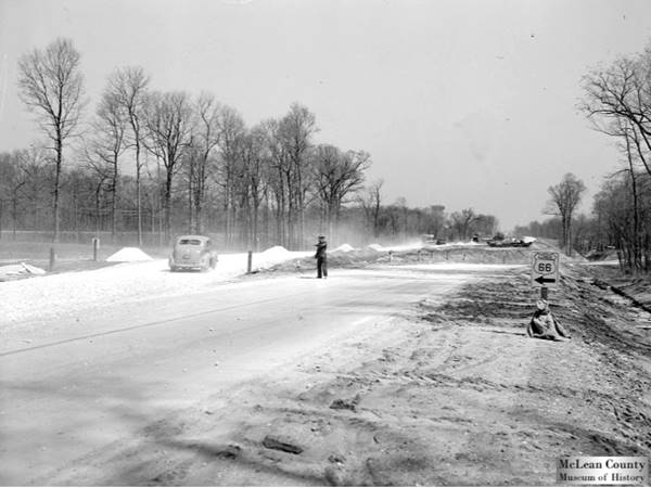
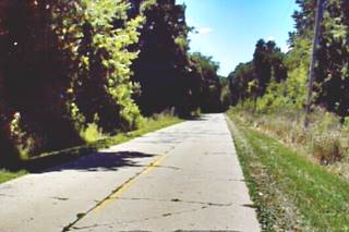
The original roadbed of US66 (1920s-1946), Funks Grove. Source
After 1946, the old roadbed was abandoned and the new one that ran parallel to the railroad was adopted. See the pink line in our custom map marking the post-1946 road.
The Grand Prairie of Illinois has small islands or patches of land with forest groves. These were places where the trees managed to survive the prairie fires and gain a foothold against the grasses. Funks Grove is the largest remaining intact prairie grove in the state of Illinois and covers more than 1,000 acres of which 443 have been designated a National Natural Landmark.
McLean
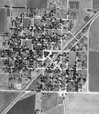
1940 aerial photo McLean IL. Source
Click thumbnail map to enlarge
The 1926-1940s alignment in McLean ran along the town's eastern side. At its southern tip it followed a different alignment to the current one: Old Route 66 didn't turn along former W Carlisle St. and S Main St as it does now, instead it continued straight and turned west at US 136 (former State Hwy 119). This junction was known as a "Death Curve." When I-55's Exit 145 was built, it disrupted the former alignment and it was realigned. Click on the thumbnail aerial photo taken in 1940 to see the original roadway. In our custom map with the alignment across McLean, US66's course is marked with a pink line.
The town was bypassed in the early 1950s with a 2-lane segment that is now under I-55's southbound lanes and marked with a green line in our custom map.
Atlanta
The highway runs next to the railroad with a NE-SW course towards the next town, Atlanta. The 1926 to 1946 Route 66 was aligned through Atlanta's downtown commercial district in a course roughly parallel to the railroad, using a pre-existing Illinois state highway 4. See the yellow line in our map.
In 1947 the highway was moved to the east, bypassing the town's business district; we marked it with a red line in our map.
Final leg from Atlanta to Springfield
Lincoln
The highway runs from Atlanta passing by Lawndale to Lincoln in a straight line as shown with this blue line in our custom map.
On the northeastern side of Lincoln the highway forks into two alignments:
The 1926-40 US66
We marked it with a pale blue line in our interactive map.
On the northeastern side of town, to the west of the modern highway you can see a segment of the original highway, now it is abandoned. This is a street view of it. And this is a Map showing where it is.
This original road continued parallel to the railroad and at the height of Harrison St. took a 45° turn south to then turn along what is now N. Kickapoo St. Most of it is now closed to traffic (except for the last section); see this Street View of the last part of the alignment (southern tip on Kickapoo).
Later (1930s?) the alignment was moved east along present Business 55 loop. From this point it heads south on the eastern side of the railroad, crosses the tracks to enter the commercial district and then heads westwards along 5th Street.
It heads south alont S Washington St. and Stringer Ave. crosses what later became Bypass 66 and ran by Lincoln's Cemetery, crossed Salt Creek and left the town.
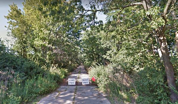
In the Salt Creek section, you can drive part of the original roadbed south of the cemetery and the creek until you reach a "Road Ends" sign (Map with directions).
1926 roadbed of Route 66 south of Salt Creek Lincoln, Illinois
1941-77 Alignment
The "Main US 66" mentioned by Rittenhouse in his 1946 Guidebook to US Hwy. 66, is the Bypass alignment that was built in 1941 and completed during WWII, to keep the heavy wartime traffic out of the downtown district (reducing congestion and accidents).
It remained operational until 1977 when the highway was decertified.
This "beltline" route ran along the western and northern edges of the city, and had an underpass to cross the railroad tracks.
Death Curve
The infamous "Blu Inn Curve" on this section, was named after a motel close to it was also known as "Killer Curve" even though it was a four-lane divided highway it was a right angle curve where speeding provoked many fatal accidents.
See this blue line in our custom map shows the bypass alignment (left side).
From Lincoln to Broadwell
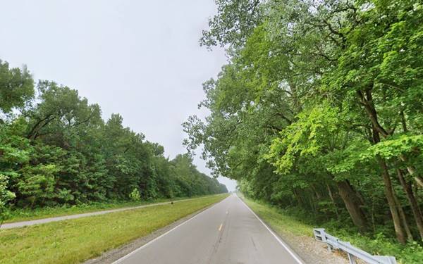
This was a four lane divided highway after the mid 1940s, but the southbound lanes are now under I-55 for most of the way, current Historic Route 66 uses the former northbound lanes. They old four lanes vanish 2 mi south of Lincoln, just past Edward R Madigan State Park, and only resurface in Broadwell; the present "Historic or Old Route 66" through town consists of the former northbound lane of U.S. Route 66. The new interstate I-55 was completed in this area in 1958 and replaced the old Route 66 with a new alignment further west.
The brown line marks the alingment from Lincoln to Broadwell and onwards into Elkhart.
Elkhart
The original highway (1926-40s) was a two-lane alignment that can still be seen on the north side of Elkhart: It is a short stretch of road 0.6 mile-long, with a cracked concrete surface you can reach it on the northern side of the silos by Elkhart. Here the original alignment curved around the western side of the town
Looking south along the 1926 roadbed in Elkhart, Illinois
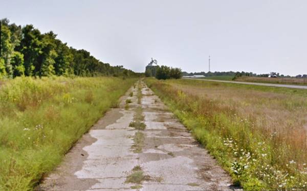
Later during the 1940s northbound set of lanes was built where Old Route 66 now runs, as shown in this 1937-47 aerial photo of Elkhart. The original curved section was incorporated to the southbound lanes. However, by 1957, the curved segment was bypassed by a second set of lanes cutting across Elkhart to carry SB traffic (1957 aerial photo). When I-55 was built, the southbound lanes were eliminated but we mark them with a green line in our custom map.
Further south and north, these lanes were overlaid by I-55. But you can see some remains of the old roadbed to your right (street view).
Williamsville
The road heads to the SW between I-55 and the railroad into Williamsville. Here, again, there are two alignments:
The purple line marks the surviving lanes from Elkhart to Williamsville and the 1926 alignment in town. As you can see it is cut at its southern tip, where it is overlaid by I-55's northbound lanes, and at the former junction of Taylor and Elm St. cut off by the 1940s bypass alignment (white line in our map), that had 4 lanes, mostly removed except for a short section along N and S Oak Streets (1956 aerial photo).
Sherman
There is a gap for the next 2.3 miles where I-55 erased the old roadways. The remains of the 1926 and the later 4-lane alignment resurface between I-55's Access 109 at Fancy Creek to the north and Wolf Road to the south, on the west side of Sherman Blvd. This is shown with an orange line in our map.
"Old" lanes of US 66 north of Sherman, Illinois
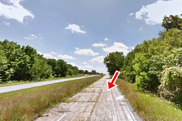
The highway drives by Sherman. South of this point, the 1940s-50s road is aligned along Sherman Blvd. and can be driven into Springfield as shown in this custom Sherman to Springfield map with directions.
But the original Route 66 ran along another alignment, the one built for State Hhy. 4, that is marked with a red line in our custom map. Part of it can be driven, part can still be seen, and part was obliterated.
In this aerial photo from 1956 you can see both alignments in Sherman all the way to the Sangamon River.
As you reach Sherman, to your left is a park with an original segment of the 1926 alignment of US 66: the "Wayside Park" on the NE corner of Sherman and E. Andrew Rd.
When cars were slow and didn't have air conditioning, traveling by car in summer was a tiring, dusty and hot business. So Wayside parks with picnic areas were built as rest areas along US 66. The one in Sherman has survived till our days, as the Route 66-Veterans park, and it also preserves a section of the original 1926 roadbed.
It was narrow: with two eight-foot wide lanes built in Portland cement 6 inches thick, and four-foot wide gravel shoulders. It was built in 1922; and there are two sections, one to the north which is 335 feet in length, and one to the south, 440 feet long. A drainage channel separates the two sections of the roadway.
At the park it turned west, along E. Andrew Rd. until it reached Old Tipton School Rd. where it turned south with a 90° turn along the stagecoach route from Springfield to Peoria. It ran through what is now Carpenter Park and across the Sangamon River into Springfield. This last section cannot be driven.
Historic Route 66 by Carpenter Park (1922-1936)
Listed in the National Register of Historic Places
The old highway is part of the Cabin Smoke Trail and Sherman Blvd. in Carpenter Park, Sherman
The historical roadway segment starts at Cabin Smoke Trail and ends at the abutment of the Old Iron Bridge on the Sangamon River. It is barely 1⁄4 mile long.
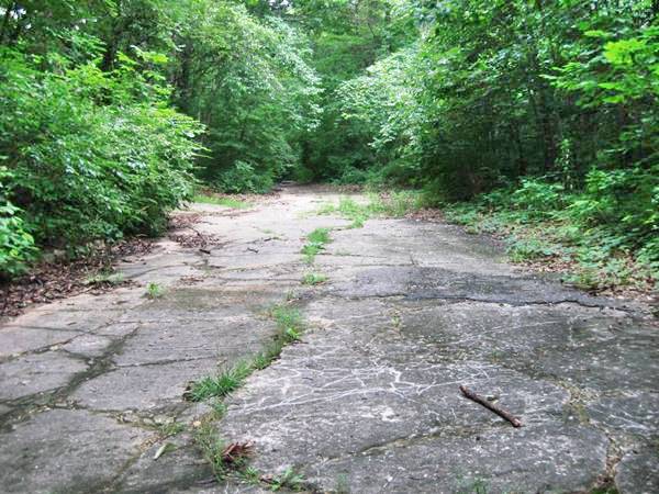
No cars have driven along it since 1936. It is a two-lane road that is 16-feet wide. Built four years before the creation of Route 66 it was included in its alignment as it was paved. It is a cement and gravel roadway with 4-foot gravel shoulders and four inch curbs. Its bridge across Sangamon River has been removed, and only its concrete abutments survive.
1936 and 40s upgrade
In 1936 the highway was realigned to the east, to make it shorter and straighter (no 90° curves). It ran south along Sherman Blvd. to the Sangamon River bypassing the Andrew Rd. section. In 1940 it was improved with the addition of two extra lanes, becoming the 4-lane highway mentioned by Rittenhouse in his 1946 Guidebook to US 66, who drove west along the new highway towards Springfield:
Here begins a 5-mile stretch of divided highway... where the new freeway is being completed Rittenhouse (1946)
Springfield, end of this leg
As you cross the Sangamon River you enter the outskirts of Springfield. Rittenhouse wrote that the "Main route of US 66" passed through the town close to the business district and was taken by those visiting the city, while "By-pass 66" took travelers around the congested capital city.
The 1926 and later alignments of entered Springfield along Peoria Rd. At its junction with Sandhill Rd. the 1940 Bypass 66 forked towards the east to run around the city.
We describe the alignments across Springfield and the Beltline or Bypass 66 in our next leg: Springfield to Hamel (1926 and 1930 alignment) and you can also see this interactive map of this alignment in Springfield.
Accommodation: Hotels along this leg of your road trip
Pontiac and Springfield have plenty of lodging options for those travelling along Route 66:
> > Book your Hotel in Springfield IL
More Accommodation nearby along Route 66
Below you will find a list of some of the towns along Route 66 east and west of this town; click on any of the links to find your accommodation in these towns (shown from east to west):
Along Route 66 in IL
- Hotels in Illinois
- Route 66 Starting point ▸ Chicago
- Lockport
- Willowbrook
- Bolingbrook
- Plainfield
- Romeoville
- Joliet
- Wilmington
- Dwight
- Pontiac
- Chenoa
- Normal
- Bloomington
- Atlanta
- Lincoln
- Springfield
- Raymond
- Litchfield
- Staunton
- Williamson
- Hamel
- Edwardsville
- Collinsville
- Troy
- Glen Carbon
- Pontoon Beach
- Granite City
- East St. Louis
West in Missouri
- Hotels in Missouri
- Florissant MO
- Bridgeton MO
- St. Louis MO
- Kirkwood MO
Continue your Route 66 Road trip:
More Route 66 Alignments
Previous Section
First segment of Route 66.
Next Sections
- Springfield to Staunton IL (1926-30 US66) south ok Springfield
- Springfield to Hamel IL (1930-77 US66) south of Springfield.
Sponsored Content
>> Book your Hotel in Springfield

Credits
Banner image: Hackberry General Store, Hackberry, California by Perla Eichenblat
Jack DeVere Rittenhouse, (1946). A Guide Book to Highway 66.


