Route 66 in Sullivan
Index to this page
About Sullivan Missouri
Facts, Trivia and useful information
Elevation: 981 ft (299 m). Population 6,799 (2024).
Time zone: Central (CST): UTC minus 6 hours. Summer (DST) CDT (UTC-5).
Sullivan is town on Route 66 which spreads from Franklin County into Crawford County, in the central Missouri Ozarks foothills.
History of Sullivan
This part of Missouri has been inhabited for since the last Ice Age, ten thousand years ago. In more recent times, the local Native Americans were an Algonquin nation known as "Illinois" (name that was deformed from the word they used to call themselves: "Illiniwek" which meant "men").
The French from Canada explored the area and claimed it for France in 1683. It was named it after their King Louis XIV ("Louisiana"). Later France ceded it to Spain, and the Spanish built a fort in the area (San Juan del Misuri) in 1796. Napoleon recovered it during his wars, in 1800 but, needing money to continue fighting, sold it to the U.S. in 1803. In 1812 this part of Louisiana was organized as the Missouri Territory (1812); Franklin County was organized in 1818, named after Founding Father Benjamin Franklin, and the State of Missouri was admitted into the Union in 1821.
The first settler in the area was Uriah Burnes ca.1829. and shortly after, during the 1830s, the Illinois, who were peacefull hunter-gatherers and squash, beans and corn farmers, were relocated together with all the other Natives that had lived east of the Mississippi to reservations in the Indian Territories (which later became the state of Oklahoma). German immigrants settled in the early 1830s and introduced grapes producing wine in the "Missouri Rhineland" and later they would side with the Union against Southern slave-owning settlers during the Civil War. The first post office opened in 1856 and was named "Mount Helicon" (the mythical Greek mountain that was home to the Muses). But it lasted for three years, in 1859 it was renamed "Sullivan".
In 1859 Stephen Sullivan platted the village, with fifty lots.
The Name: Sullivan
Stephen and Dorcas Sullivan were pioneers, they bought 169 acres of land and donated part of it for the railroad's right of way and depot; Stephen built the first depot too. The "Frisco" railroad named it
after him, and that led to the change in the post office name.
Sullivan is a Gaelic name from Ireland (O Suileabhain) that comes from the word "suil" = "eye".
It was a farming community located on the main road linking St. Louis with Springfield (the "Wire Road" because it ran next to the military telegraph line). Later Route 66 was aligned along that same road (1926) and it brought a flow of visitors who lodged in the town, used its gas stations and cafes. This would continue even after the road was realigned on the town's western outskirts in the 1950s. Today I-44 runs on the later US 66 roadbed.

Sullivan Trivia
The father of famous media tycoon and publisher, William Randolph Hearst, George Hearst (1820-1891) was born in Sullivan.
Where to Lodge in Sullivan, Missouri
Accommodation and hotels in town; there are some good motel options in Sullivan so you shouldn't have difficulties in booking your room.
> > Book your hotel in Sullivan
More Lodging along Route 66
There are several hotels in the area close to this town. Alternatively you can also find your accommodation along Route 66 in the neighboring towns and cities in Missouri. We list them below (from east to west):
On Route 66's Main alignment in MO
Eastwards
Westwards
- Hotels in Kansas
- Baxter Springs KS
- Galena KS
- Riverton KS
- Hotels in Oklahoma
- Miami OK
>> Check out the RV campgrounds in Sullivan
Weather in Sullivan

Location of Sullivan on U.S. Hwy. 66
Sullivan has well marked seasons, which are the combination of humid continental and humid subtropical climates.
The winter (Jan), the average high is around 39°F (4°C) and the aveage low is a freezing 20°F (-7°C). The summer (Jul) average high is 89°F (32°C) with an average low of 68°F (20°C). Rainfall averages 44.5 in. (1.130 mm) yearly which ranges from 2.21 in (56 mm) in Jan. to 4.81 in (122.2 mm) in May. Snowfall is around 18.9 in. (48 cm), which falls from Dec. to Mar.
Tornado risk
Sullivan is located in Missouri's "Tornado Alley" and Franklin County is struck by some 7 tornados every year. Tornado Risk: read more about Tornado Risk along Route66.
Route 66 map and alignment in Sullivan
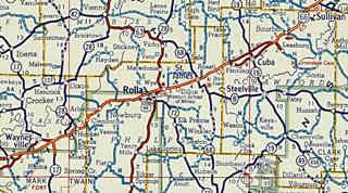
Click on the thumbnail image to enlarge it. It is a Shell road map published in 1956, it shows the alignment of Route 66 from Sullivan (upper right) to Waynesville through Rolla (in the middle of the map). Driving west from Stanton to Sullivan, the original 1926-50 alignment is shown in this map all the way to the north side of Winsel Creek just past Glaser Rd.
Route 66 alignments at Winsel Creek over the years
1926-Late 1940s
As you approach the creek, the original 1926 to late 1940s Route 66 had an "S" shaped alignment from 1926 until the late 1940s. See this alignment in this map (yellow line) and in the following images (click on the thumbnails to see full sized pictures):
The red arrows mark the original Route 66 alignment used from 1926 to the late 1940s. The blue arrow at the bottom shows where it continues on the eastern side of the freeway that now cuts the old roadway.

Aerial photograph from 1945. Source
Tragic Curve
Lowell Silverman wrote an excellent article on the life of 2nd Lieutenant Paul W. Taylor (1911–1942) (read the full article) who died in a tragic accident here on this curve at Winsel Creek, on Route 66 during World War II.
On the night of September 27–28, 1942, Taylor and five other officers were traveling back to Fort Leonard Wood on U.S. Route 66 in a Chevrolet coupe. Shortly after midnight their vehicle collided with a cattle truck roughly midway between the towns of Stanton and Sullivan, Missouri. Three men were killed: 2nd Lieutenants Taylor, Ennas Calvin Cave (1919–1942), and Booker T. Owens (probably 1913–1942), the driver...Lowell Silverman
We marked the spot of the accident with a cross in our custom map.
1949 alignment
As shown in the USGS map published in 1949 (above) this original "S" on the upper right side of the map was cut off by a new 2-lane roadway (perhaps built during WWII?), it runs straighter than the old one, and bypasses Sullivan along its western side. This two-lane highway complements the original one going through Sullivan. The map doesn't clarify if they both carried east and westbound traffic or if they were exclusively eastbound (old 66) and westbound (new-straight alignment). See the (map of this segment).
1955 Alignment
By 1955 (see image below), the four-lane Route 66 had been built and its dual set of lanes finally cut off the original 1926 roadway at Winsel Creek. What are now the North and South Service Roads didn't exist at that time.
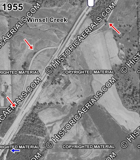
Aerial photograph from 1955. Source
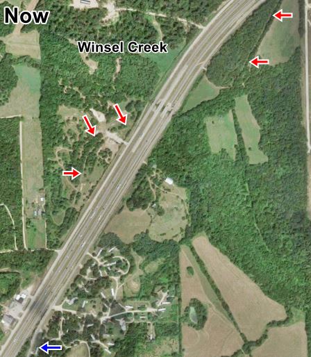
Satellite view nowadays
Current alignments
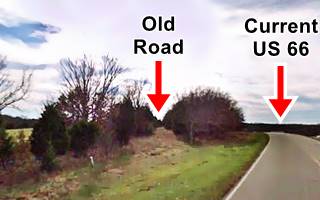
The current satellite view of the area (above) shows the modern I-44 that replaced the old four-lane US66 (eliminating grade crossings), and the "modern" US 66 running along the eastern side of the freeway. It replaced the old alignment, which was abandoned but can still be seen in some spots, lined with trees (marked with
the red arrows). The images shows a current view of the old roadway on the north side of Winsel Creek and the "modern" US 66 which was built later, as the freeway's service road.
On the south side of the creek (blue arrow) the original 1926 road can be driven across Sullivan till it ends on its south side at Cristland Dr. See this map of Route 66 across Sullivan. West of this point the old roadbed lies beneath the EB lanes of I-44 as shown in this map (orange line).
The Route 66 alignment in Sullivan
Visit our pages with old maps and plenty of information about US 66's alignments.
- Rolla to Springfield (next)
- Gray Summit to Rolla (in Sullivan)
- Route 66 in St. Louis (previous)
Route 66 Sights in Sullivan
Landmarks and Places to See
- City Tour of Sullivan, read below
- Tours & Itineraries
- Parks and outdoors
Historic context, the classic Route 66 in Sullivan
"Missouri, a guide to the "Show Me" state" a guide published by the WPA in 1941 mentioned is two shoe factories and its history. The 1946 book written by Jack DeVere Rittenhouse ("A Guide Book to Highway 66") tells us more:
"SULLIVAN. (...Campbell Chevrolet Co. garage; Grande Courts, Sullmo Cabins; cafes.) The main business district of the town is off US 66, which touches the western edge of town. Rittenhouse (1946)
Rittenhouse mentioned that Meramec State Park entrance was just north of town, and gave a description of the park and the famous cave.
US 66 Sights and Stops in Sullivan
Start your tour in eastern Sullivan, heading west from neighboring Stanton (further up we described the alignment at Winsel Creek. Head west and you will cross another branch of Winsel Creek where a bridge built in 1922 that carried Springfield Hwy, State Hwy 14 and later Route 66 was replaced by a new one a few years ago.
Martha Jane Farm - auto court
To your right, 0.2 miles from the bridge is the old "Martha Jane Farm", an Auto Court. according to Gene Wagner, Preston Pyser of Washington MO, moved to a
farm in Sullivan where he built a two-floor, nine room home to retire there in the early 1930s. Seeing the traffic passing by his home he
added cottages behind the house, and named the place after his wife "Mary Jane".
Gene's parents, Ed and Edna Wagner bought the place in 1946.
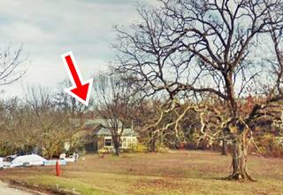
The family ran the place until 1970 when I-44 replaced the old 4-lane Route 66 and cut off the motel from the main highway. They sold the property at that time. The postcard below reads "Martha Jane Farm "Auto Court Deluxe" - "Wonderful Place in the Ozarks" - 1 mile E. of Sullivan Mo on Hi 66." The red arrow marks the old building, that is still standing.
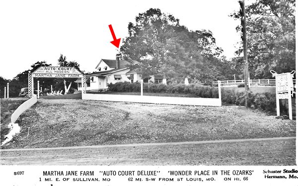
The place had two entrance roads, only the western one has survived. Across the street, Ira and Alma Bland owened a now defunct restaurant and had two small cottages.
Deadly Curve
Wagner also mentioned the deadly curve that was next to their motel, to the west: "... up the hill, was a very bad lefthand curve coming east out of Sullivan. There were so many accident we soon lost count."
Drive westwards (along the curve) and head into town, after 0.9 mi, to your left (map) is a Route 66 themed fire hydrant!
Route 66 Hydrant Mural Project
This project is part of the "Adopt-A-Hydrant" project but focuses on the twenty-seven fire hydrants located along Route 66 in Sullivan. The hydrants are being painted to depict a city, landmark or remarkable spot along the Mother Road from Chicago to Santa Monica. The murals are placed in the correct east to west alignment along the highway starting with Chicago: The "Begin" hydrant is located on the SE corner of Mary St. and Route 66 and depicted below.
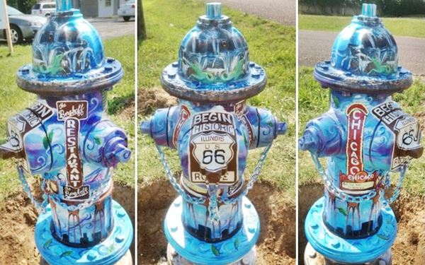
There are more, keep your eyes open for them or check where they are on the Route 66 Hydrant Project website to see pictures of each hydrant.
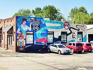
Drive 0.2 miles and to your right at 227 E. Springfield is the town's Route 66 Mural:
Sullivan Route 66 Mural
The mural is on the east facing wall and depicts a nostalgic route 66 scene: a diner waitress, a juke box, a vintage car, Sinclair and vintage gas logos plus a map across the country showing Sullivan with a "You are Here" arrow. It is pictured below.

The White Swan c.1940s, Sullivan MO. Source
Site of the White Swan restaurant
Drive two blocks west, and at North St. and Route 66, to your left, on the SE corner where the Walgreens is now located once stood "The White Swanw" restaurant and next to it, on the corner, the Standard Oil station with a tall stone tower standing over its steep gable roof. It was operated by Fred Snell Sr., who later owned Snell's on the 4-lane 1950s alignment. See picture above.
Sullmo Hotels and Cabins
Ahead, to your right, on the NW corner where St. Anthony Catholic Church School is now located, once stood the "Sullmo Cabins" it began as a private home and later became a hotel with cabins on its western side. Later it became a convent for St. Anthony's nuns and it was razed in the 1970s to make space for the school (red arrow below).

The Sullmo Hotel & Cabins 1940s, Sullivan MO. Source
Sullivan IOOF Cemetery
Turn right along N. Church St. and visit this cemetery, just one block north of Route 66. (Map with location).
The "Independent Order of Odd Fellows" (IOOF) is a secret society without any political or sectarian orientation. It was founded by Thomas Wildey in Baltimore, USA in 1819.
The local Lodge (No. 156) was instituted in 1901.
In 1945 they puchased the land for this cemetery.
James ("Sunny Jim") Leroy Bottomley (1900 – 1959), professional baseball player is buried here. He was elected to the National Baseball Hall of Fame in 1974, in 1924 he set the record for 12 RBI's (Run batted in statistic). He retired to Missouri and rests here with his wife.
Turn back to Route 66. You can take a detour and take a short side trip to visit a historic building from the 1850s, or skip it and head west:
Harney House
Listed in the National Register of Historic Places
At 332 S. Mansion Ave., 1.8 mi round trip (Map with Directions). This modified Swiss Chalet was built in 1856 by Dr. Leffingwell. He sold it in after the Civil War to General William S. Harney (1800-1899) as a family and summer home. Has 35 rooms of which 25 are bedrooms!
Continue your Route 66 Tour
Return to Route 66 to continue your city tour and visit "Route 66 Splash Park", a Modern Attraction on Route 66, and the 1950s classics on the norht side of the freeway along the old four-lane Route 66: four old motels and a cafe. This map with directions shows the itinerary (3.8 mi.)
After this you will return to Historic Route 66 on the south side of the freeway to visit the last two US66 sights in town, the iconic Shamrock Motel and the Martin Family Cemetery.
Route 66 Splash Park
The Route 66 Splash Park's official name is "Sunny Jim Bottomley Park". It is located at 305 Fisher Dr. and it is named after the local celebrity (buried in the IOOF cemetery). Open from May 1st to Oct. 1st, it complements the park's pool, tennis court, and roller skating rink. Kids love to play here with the water guns, jets and sprayes. The gigantic Route 66 shield is worth a picture. See this street view.
Grande Courts Motor Hotel
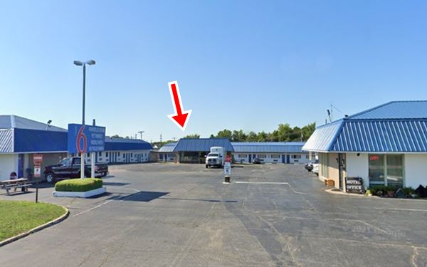
Now head west, cross the interstate and turn right to visit a classic motel and the site of a now razed restaurant. To your left, at 209 North Service Road West. It began with 40 rooms, as a motor court, with cottages and garages, including a pool and "all-night watchman". It had a "U-shaped" layout around a central courtyard with a swimming pool. Later it was refurbished and became the Hitching Post Motel and the Family Motor Inn (it still had the pool until 2017 as you can see in this image of the motel). Now it is a "Motel 6". The swimming pool has gone, but the building behind it has survived -though quite altered; see red arrow in the images below.
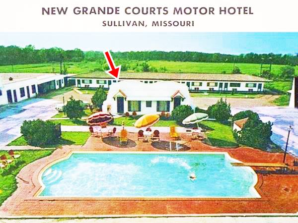
Site of Snell's Cafe
Its slogan was Awful Good Food. Fred L. Snell Sr. (1891-1970) owned it and operated it (he also ran the White Swan). He moved to the new four-lane alignment and built his cafe with a Pueblo - Sothwestern style similar to that of the adjacent Grande Courts, with a rough white stucco walls and curved parapets. Later it became the "Hitching Post" restaurant and an antiques mall. It was razed (2021 Street view). Below is a "Then and Now" set of pictures.

Snell's Cafe in a 1950s postcard. Sullivan MO. Source
Site of Sunrise and Sullivan Motels
Turn around and head west along the North Service Road to see the sites of two classic motels that were torn down when the freeway overpass of Elmont Rd. was built in 2007. You can see both motels in this 2003 aerial photograph. The "Sunrise Motel" stood on what is now the southwest side of Elmont Rd. Overpass a (Map with location). left. The Sunrise motel's signs have also gone, all that remains is the concrete driveway and court.
Across the freeway, on the northeastern side of Elmont Rd. once stood the "Sullivan Motel" (map), nothing remains of it. Head west along the N. Service Road for 1.1. mi. to visit another 1950s Route 66 Motel, gas station and restaurant, the Hi-Lo
Hi-Lo Court - Motel
At 4095 Service Rd. W. This former motel (now it has apartments), next to the Route 66 RV park, used to advertise itself in its postcards as: "Hi-Lo Courts. Modern accommodations, air conditioned, T.V. service, fine restaurant in connection, weekly rates", in a 1956 advertisement it promoted itself as follows: "Tourist Cabins, Restaurant, Filling Station, Liquor Store - One Mile West On Hwy. 66 Sullivan, Missouri". The flat roof was replaced by a gable roof and then neon sign is gone. When Route 66 upgraded to interstate standards limitng access to overpasses, it was cut off and stranded 1.1 miles from the nearest exit.


The two last Route 66 attractions in Sullivan
Turn around and retrace your steps to Edmont, then head west for the two final Route 66 road trip attractions in Sullivan (map with directions).
Shamrock Motel
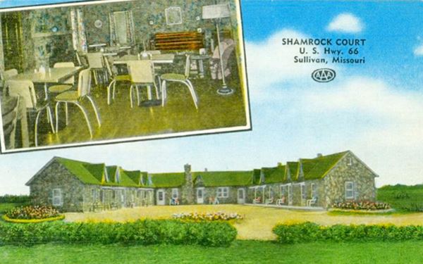
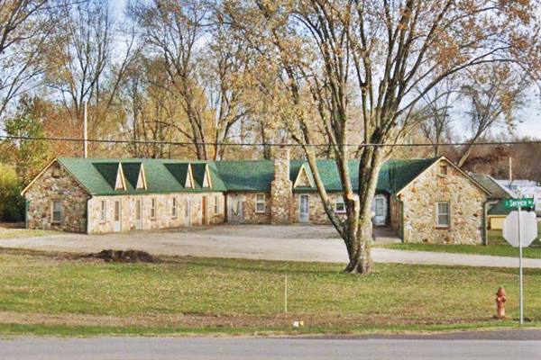
1240 West South Service Rd. Sullivan. The service road was the original alignment of Route 66 and F. E Dobbs opened the motel in 1945, just at the end of WWII. It was built with a "U-shaped" layout around a central courtyard by a local stonemason in hand-cut Ozark sandstone. It was a Motel and Restaurant. Now it is closed but being restored by its owner. See it in a "Then and Now" sequence below:
Vintage postcard of the Shamrock Motel on Route 66 in Sullivan Missouri
Shamrock Motel on Route 66 in Sullivan Missouri
Head to west towards Bourbon and see a small Family cemetery:
Martin Family Cemetery
Historic Route 66, (0.8 mi. west of the Shamrock Motel. Walled in, to your right, sandwiched between Route 66 and I-44, it is a family burial plot.
John Martin was buried here in 1861, and Phebe E. Martin in 1863.
This is marks the end your Route 66 road trip through Sullivan continue your trip by heading west and visiting Bourbon.
State Parks and Outdoors
Meramec State Park
Historic Missouri sites: Beach, Shelter and Observation Tower and Pump House.
Less than four miles east of Sullivan via Missouri Highway 185. Created in 1926 it protects over 40 caves and a forested landscape. Don't miss Fisher Cave with massive columns and bear claw marks from the past. Rafts and canoes can be rented to have fun on Meramec River. You can fish and trek along its 13 miles of hiking trails or swim. The park has RV campsites, cabins, and a hotel. Read more at the Park's Website.

Some sponsored content
> > Book your Hotel in Lebanon

Credits
Banner image: Hackberry General Store, Hackberry, Arizona by Perla Eichenblat
Jack DeVere Rittenhouse, (1946). A Guide Book to Highway 66
Sullivan Century Book, 1956
Gene Wagner (1998), Martha Jane Farm Auto Court Deluxe


