A Dash of Bourbon on Route 66
Index to this page
About Bourbon Missouri
Facts, Trivia and useful information
Elevation: 942 ft (287 m). Population 1,632 (2010).
Time zone: Central (CST): UTC minus 6 hours. Summer (DST) CDT (UTC-5).
Bourbon is town on Route 66 in Crawford County, in the central Missouri Ozarks foothills.
Bourbon "water" tank Route 66 in Bourbon Missouri
History of Bourbon
Check our Cuba - history post for information on the general history of this region. The first settler in the area was Uriah Burnes ca.1829. The first post office was opened by Richard Turner and his partner Lamar, who owned a store here, in 1853. It was named "Bourbon in the village of St. Cloud" because the townsite of St. Cloud was originally laid out here, but later it was moved further west. Turner's store sold all kinds of goods including "Bourbon", and this is the origin of a myth regarding its name:
The Name: Bourbon
The local legend is that the railroad workers went to Turner's store to buy the liquor as he was the first to sell it here, and that the place was known after it. However the store and post office predate the railroad by six years so the story is very likely untrue. Probably named after the French and Spanish royal families, of the Bourbon dynasty, which were sympathetic towards the American Revolution.
The small farming community and incorporated in 1907. Route 66 was aligned through the town in 1926, and several new stores opened to cater to the travelers: garages, service stations and cabins. This continued until 1953 when the new four-lane alignment of US 66 bypassed the old business district.
Bourbon the liquor
The Kentucky settlers of the late 1700s were Scots, Irish, Welsh, English and some French and Germans, produced a spirit distilled from corn, which later became known as Bourbon because it originated in this area, the old Virginia county of Bourbon, created in 1785 and which spanned most of what today is eastern Kentucky. Bourbon was named so in honor of the French Royal family (four years before the French Revolution).
New Bourbon, Missouri
The other Bourbon in Missouri, is an abandoned village 68 miles east of Bourbon (of Route 66) in Ste. Genevieve County Mo. named after the Royal Spanish and French dynasties. Its founder used that name to make it more friendly for French migrants.

Where to Lodge in Bourbon, Missouri
> > Book your hotel in neighboring Cuba
More Lodging along Route 66
There are several hotels in the area close to this town. Alternatively you can also find your accommodation along Route 66 in the neighboring towns and cities in Missouri. We list them below (from east to west):
On Route 66's Main alignment in MO
Eastwards
Westwards
- Hotels in Kansas
- Baxter Springs KS
- Galena KS
- Riverton KS
- Hotels in Oklahoma
- Miami OK
>> Check out the RV campgrounds close to Bourbon (Leasburg)
Weather in Bourbon

Location of Bourbon on U.S. Hwy. 66
Bourbon has well marked seasons, which are the combination of humid continental and humid subtropical climates.
The winter (Jan), the average high is around 39°F (4°C) and the aveage low is a freezing 20°F (-7°C). The summer (Jul) average high is 89°F (32°C) with an average low of 68°F (20°C). Rainfall averages 44.5 in. (1.130 mm) yearly which ranges from 2.21 in (56 mm) in Jan. to 4.81 in (122.2 mm) in May. Snowfall is around 18.9 in. (48 cm), which falls from Dec. to Mar.
Tornado Risk
Bourbon is located in Missouri's "Tornado Alley" and Crawford County is struck by 7 tornados every year.
Tornado Risk: read more about Tornado Risk along Route66.
Route 66 map and alignment in Bourbon
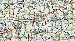
Heading west from Sullivan the highway is in part buried under the freeway's eastbound lanes as you can see in this map (orange line) or runs close to it following its South Service road (map to Bourbon).
Click on the thumbnail image to enlarge it. It is a Shell road map published in 1956, it shows the alignment of Route 66 from Sullivan (upper right, Bourbon is the next town to the left) to Waynesville through Rolla (in the middle of the map). At that time the highway was mostly a four lane highway, one that preceded current I-44. Notice the split alignment through Cuba.
The Route 66 alignment in Bourbon
Visit our pages with old maps and plenty of information about US 66's alignments.
- Rolla to Springfield (next)
- Gray Summit to Rolla (in Bourbon)
- Route 66 in St. Louis (previous)
Route 66 Sights in Bourbon
Landmarks and Places to See : Get your Kicks in Bourbon
- Bourbon City Tour, read below
- Tours & Itineraries
- Parks and outdoors
Bourbon and its Route 66 attractions
Historic context, the classic Route 66 in Bourbon
"Missouri, a guide to the "Show Me" state" a guide published by the WPA in 1941 does not mention Bourbon, but Jack DeVere Rittenhouse's book "A Guide Book to Highway 66" published in 1946 has the following entry:
BOURBON (...Roedemeier garage; few cabins; gas; cafes is a smaller village with its business district a few blocks off US 66... ...
ïs a road (Left) to Onondaga Cave, another of the most popular caverns in Missouri... a deep, mysterious cavern, with an underground river, "rooms" of striking onyx formations and other unusual features.Rittenhouse (1946)
Rittenhouse added that at the junction of US66 with the side road to the cave (County Rd. H) there was a "gas station and two inns".
Sights in Bourbon
As usual, we describe this leg of your Route 66 Road Trip, starting on the eastern side of Bourbon and heading west through the town, and onwards towards Hofflins.
As you reach the town Route 66 moves away from the freeway, following the railroad tracks. To your right is the old Hill Cemetery, its oldest graves date back to 1865 (according to findagrave.com).
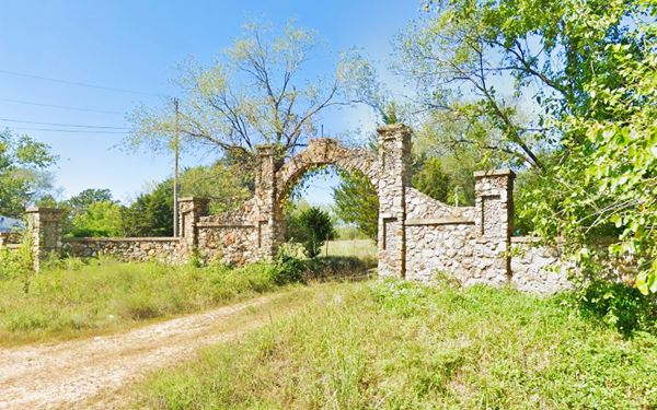
Old Rock Arch
Just ahead, Route 66 curves away trom the railroad and heads west, here, to your right is a magnific stone archway that is the entrance to a farm. See the barn in the background (Street view).
Route 66 continues west so follow it for 0.5 mi., to E. Pine St. and take a short side trip to visit the "Old" water tank: turn right, cross I-44. There, to your left, on the north side of the freeway is the "Old Bourbon Tank" (pun intended):
Old Bourbon Tank
Classic Route 66 Landmark
On N. Service Rd. & Hwy. J
No longer in use, it is kept as a landmark, a tank of Bourbon! Further west you can see the new tank at the next exit. Retrace your steps back to Route 66 as shown in this map.
Turn right along Route 66 and just ahead, where the highway almost touches I-44 and curves sharply towards the south (at Rotlen Ln.). here you can see some old Route 66 landmarks.
Sweeney's Steak House & Roudemeier's Garage
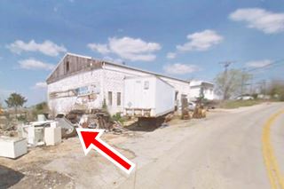
To your right, now it is Bourbon Recycling, but at one time it was a busy stop on Route 66 called Sweeney's Steak House, it had a cafe and a Standard Service Station, and on the "old 66" the garage.
You can see it in this 1955 aerial photograph as a dark rectangle above Route 66 (that curves away), and next to the 1950s four-lane highway that cuts across the left side of the photo.
Later it was purchased by R.D. Sweeney who renamed it.
Below is a "Then and Now" set of images, the block wall that is still standing, can be seen in the 1960s picture, with the words "Cafe" and "Standard" written on it. Route 66 is on the right side of that picture.
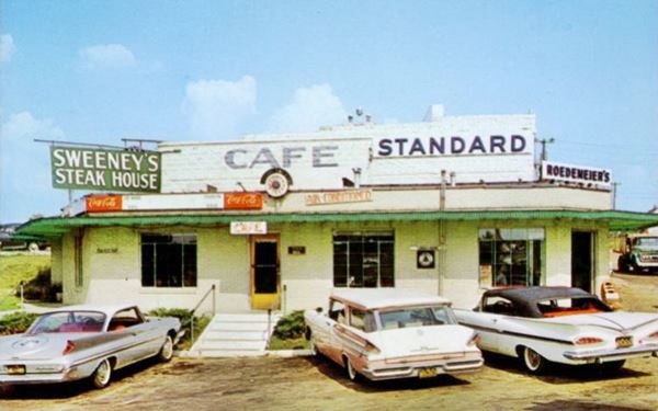
Roedemeier Garage
Facing Route 66, the garage was originally owned by the Souder Brothers, and later bought by Oscar Roedemeier, who opened the cafe. He later (in the early 1960s the family opened the motel that is just ahead).
The red arrow marks the spot where the cafe, now torn down, once stood. The gable roof was added later, notice the same block wall facing west in both "Then" and "Now" photos and also check this street view with its southern facade.
Roedemeier Motel
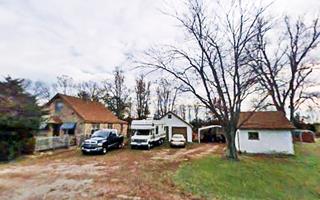
After the curve, at 351 Old Route 66 is an apartment complex that at one time was "Roedemeier Motel".
It's postcard states that it was "For the Rest of your Life". It was opereated by Kermit and Faye Roedemeier, and it offered "Air Conditioned, Free TV, Hot Water Heat, Carpeted, Tile Tub and Shower Comb, Standard Service and Garage, Restaurant".
The motel does not appear in the 1955 aerial photograph, but it shows up in the one taken in 1967.
The main motel's units building (red arrow) is still standing, but the canopy over the entrance is gone and the office now is a two story building, see the "Then and Now" sequence below.
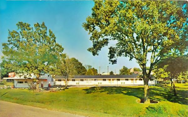
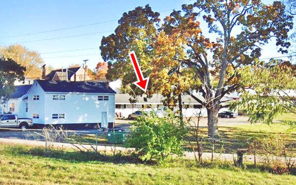
It looks like the same tree is in both pictures!
Bourbon Hotel

"Old Bourbon Hotel" in Bourbon Missouri, Source. Click for St. view
Historic 66 road heads southwards into the downtown area of Bourbon. At its intersection with Pine St., turn left along E Pine St. and, 0.1 mi. ahead, to your right at 251 E Pine St. you will spot the old "Bourbon Hotel building".
The old railroad hotel is a red brick structure with three stories. It is abandoned and was built ca. 1890, facing the railroad depot. It tended to Route 66 traffic as the railway passengers declined after the 1930s.
Don't miss the "ghost sign" on the brick wall at the back of the hotel (A ghost sign is an old hand-painted advertisement that has survived on a building for a long time and not been removed or painted over); it says "Bourbon Hotel"
New Bourbon Tank
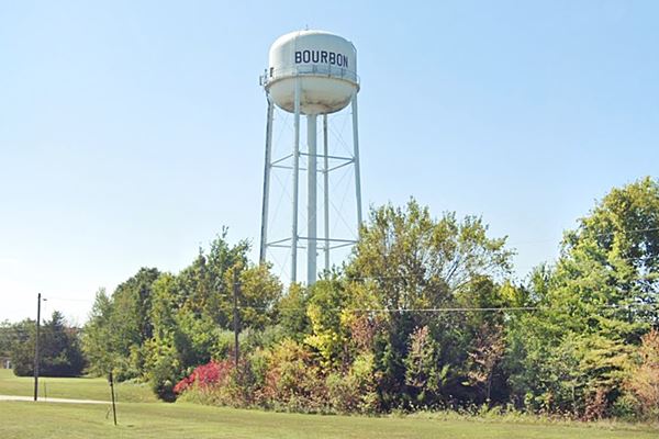
Turn around and head back down Pine St. towards US 66, cross it and go west to the freeway, 0.3 mi. Here you can see the new Bourbon Tank and water tower to your left, on the north side of I-44 at Exit. 218 at N Service Rd. & Paramount Dr.
This is the town's "real" water tower and it is pictured above at the top of this page. Turn around and return to Pine St. and Route 66, take a right and just ahead, to your left is the iconic Circle Inn.
Circle Inn Malt Shop

Circle Inn Malt Shop's Neon Sign, Bourbon Missouri. Source
At 171 S Old Highway 66, Bourbon. Now it is permanently closed.
Originally it was a simple building: box-shaped with a flat roof, large windows, and concrete-block structure, typical of its time (1955).
It advertised "Malts - Shakes Carry Out". It was built by Bud and Marie Ware and remained in the family since then, first ran by their son Bob Ware (1948-2011), who purchased it from his parents, and then by his son Joshua Ware.
It closed in 2019.
The American Sign Museum website has an almost identical neon sign in their files Read more about it.
The sign with the word "FOOD" on it has survived also and stands over the building. Below is a "Then and Now" set of pictures:
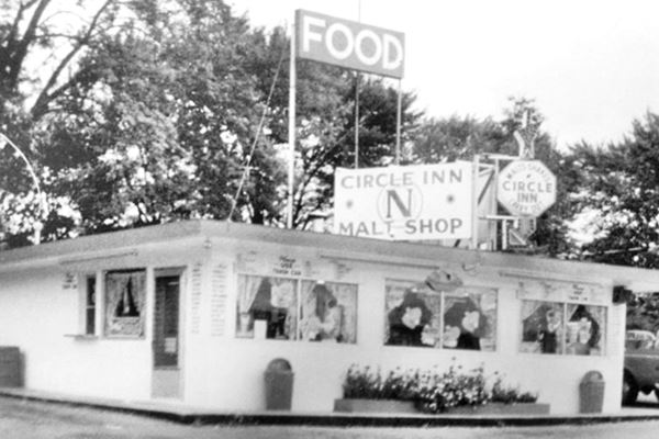
It has changed: it replaced the flat roof with a hipped one, and it expanded lenghtwise, with seven windows instead of three facing Route 66:
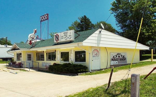
Continue your westbound jorney for another 0.9 mi to visit another Classic Route 66 Cafe & Service Station with cabins:
Bourbon Lodge
At 834 Historic Route 66 (map with directions).
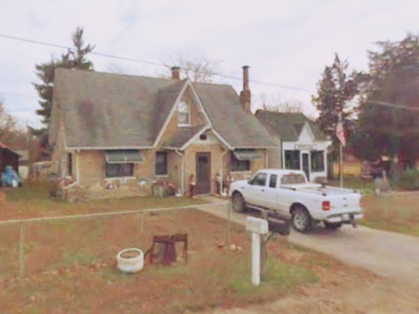
It opened in 1932 and was run by Edith and Alex Mortenson. The complex initially had a café and three cabins, later a Phillips 66 gas station was added as well as another cabin. They sold it in the 1940s, during WW II. Now it is a private residence, but the place is still in good shape (the Café is the building to the east - left and the old service station to the west -right).
Old postcard of the Bourbon Lodge Cafe & Gas Station and Cabins in Bourbon, Missouri Current view of the Bourbon Lodge Cafe & Gas Station and Cabins in Bourbon, Missouri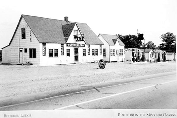
High Hill Cabins (High Hill Tourist Court)
Head west, and after 0.5 miles, facing Bourbon High School (map with directions) is another old cabins site at 1500 Historic Route 66 on the left side of the highway.
After Edith and Alex Mortenson sold the Bourbon Lodge, they moved close by, and built another service station, a Texaco with cabins.
Some buildings are still standing. They sold it in 1947 to the Heitmans, who ran it until 1955, by then this old section of Route 66 had been bypassed by the freeway built to the north
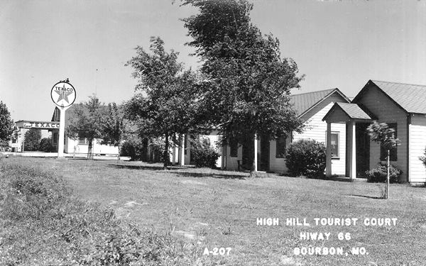
Below is its current appearance and an aerial photograph taken in 1987. The Texaco station is the building on the left (east); click on the thumbnail for a full sized aerial photograph:
This marks the end of this leg of your Route 66 Road Trip across Bourbon Missouri. But you can drive on, westbound, to visit some more local sights that are near the town (read more on this below):
Tours & Itineraries close to Bourbon
West along Route 66 to Leasburg and Onondaga Cave State Park
Drive westwards along Route 66 from the High Hill Cabins site to the intersection with MO-H (3.2 miles).
Leasburg Junction
Route 66 curved south, and there was a "T" intersection with the highway leading to Leasburg two miles south. On the north side of Route 66 was the "Junction Inn" mentioned by Rittenhouse, now gone; it was razed to extend Hwy H towards the freeway's Exit 214.
The buildings just east of the junction date back to the 1940s and were mentioned by Rittenhouse: a gas station and inn; see a Street View; they can also be seen behind the trucks in this vintage postcard.
There are later 1960-70s buildings at the intersection: to your left, on the SE corner is "Skippy's Restaurant and Bar" at one time it was the "Coachlight Inn". Facing it, on the SW corner was the former Outpost Restaurant, all that remains are the steel poles that held up its sign.
Old Route 66 Oakgrove Roadside Park
It was permanenty closed by the Missouri Department of Transportation in the mid 2000s, and its circular roadway was blocked (street view), the tables and signs were also removed.
It was created here on the old alignment of Route 66 before the freeway was built in 1953. It is located just west of the intersection with Hwy H, on the right side (north) of the road. You can see it in the thumbnail image (click on it for a full size view).
It was the original location of the "Blue Star Memorial Highway Marker". But, when the new four-lane Route 66 highway upgraded to Interstate standards, the access to the park was cut off. So as nobody could reach the park -or visit the Marker, when Hwy. H. was extended to the freeway to the Leasburg Exit, the marker was moved to the new Hwy H.
Blue Star Memorial Highway Marker & Crawford Co. Marker
State Historical and Blue Star Markers
180 feet west (right) of MO-H and US66, heading towards Exit 244 of I-44. The markers are on the western side of the highway (left).
The Blue Star marker appears to have been removed (2021), its stone pedestal is still there. It was erected after WW II by the Federated Garden Clubs of Missouri and the Federated Garden Club of Leasburg together with the Missouri Dept. of Transportation. Its text read: "BLUE * STAR - MEMORIAL HIGHWAY - A tribute to the Armed Forces that have defended the United States of America". See its Street View showing the stone pedestal, the bridge, and Crawford marker on the left.
The second marker was erected by the Historical Society of Missouri and State Highway Commission in 1961, and its inscription details the county's history.
At this point you can head west towards to continue your road trip and visit Hofflins and Cuba or take a short trip to visit Leasburg and Onondaga Cave:
Side Trip to Onondaga Cave
A 14 mi. Round trip from the Old Oak Grove Roadside Park (Map with directions), going through the town of Leasburg.
Leasburg
Settled by Samuel Lea (hence its name) and originally named Harrison Station on the Frisco Railroad. In 1859 the post office was named Leasburg and the town dates back to 1869. Best known for the Caves (in plural because there are many of them).
Caves in the area: Cathedral Cave with stalagmites and stalactites. Missouri Caverns which opened in 1932 with onyx of a pinkish color and gravel paths. Formations (King's Canopy, Live Oak) and the Lost River. Sake Pit Cave, actually a collapsed cave or sink, with an underground lake and snakes among the ferns; and the most famous of them all "Onondaga Cave" that we describe below.
National and State Parks
Onondaga Cave State Park
National Natural Landmark

Vilander Bluff. Source
It was the first tourist cavern in Missouri. It opened in 1904 -in those days you had to take the Frisco train to Leasburg and then by carriage to the caves. It has a boat along the Lost River and then gravel path in the cavern to see the formations with colored onyx: Onyx Forest, Wonder Room and Cathedral Hall. The name is Iroquois and is said to mean "spirit of the mountain". It became a state park in 1982.
Read more at the Park's Website (there is an RV campsite there too).
Visit Vilander Bluff for a panoramic view of the Meramec River, fish or canoe in the river (read more about Vilander Bluff).
This is also the end point of your Route 66 road trip through Bourbon; keep on driving westwards and continue your trip towards Cuba.

Some sponsored content
> > Book your Hotel in Lebanon

Credits
Banner image: Hackberry General Store, Hackberry, Arizona by Perla Eichenblat
Jack DeVere Rittenhouse, (1946). A Guide Book to Highway 66


