Site of a vanished village
Index to this page
About Hofflins Missouri
Facts, Trivia and useful information
Elevation: 1,037 ft (316 m). Population n⁄a (2010).
Time zone: Central (CST): UTC minus 6 hours. Summer (DST) CDT (UTC-5).
Hofflins is an unincorporated comunity on Route 66 in Crawford County, in the central Missouri Ozarks foothills.
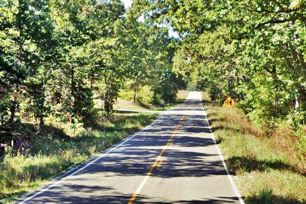
Looking down Route 66 in Hofflins, Missouri

History of Hofflins
Check our Cuba - history post for information on the general history of this region.
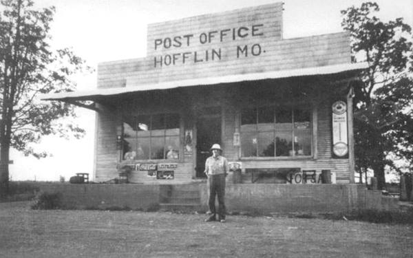
The Frisco Railroad completed is line through the area around 1858 and shortly after, Walter L. Hofflin bought a large piece of forested land to extract timber and shipp it out by rail. The cleared property became his farm. He had the railroad build a stop and it was named "Hofflin". The post office opened in 1903, and he was the postmaster and also owned the local General Store.
The Name: Hofflins
The post office was named after the railway station, which was named after Mr. Hofflin, the first settler. However the USGS maps of 1948 (see below) added a final "s" to the name, which became "Hofflins". The surname has the root "Hoff" and a diminutive suffix "-lin" as found in Zimmerlin or Oberlin and so on, which is from the lower Alemannic region (Switzerland, Alsace and Southern Baden) Hoff derives from the Old German word "hof": court, farm, settlement.
He sold the land and store to Moses Kaluber, who ran it until 1920, selling the property, which was then subdivided. The old General Store was operated by the McWilliams and later by the Libharts, who were also postmasters until the post office closed for good in 1943.
From 1926 to 1954, Route 66 went through Hofflins, and the General Store provided some services tot those driving along it. But it was too close to Cuba to have any motels or gas stations. In 1954 the Old Route 66 became the eastbound lanes until 1968 when the four-lane divided section was built from Hofflins to Fanning permanently bypassing the village, that soon died.

Where to Lodge in Hofflins, Missouri
There aren't any hotels or motels in Hofflins find your room in neighboring Cuba.
> > Book your hotel in Cuba
More Lodging along Route 66
There are several hotels in the area close to this town. Alternatively you can also find your accommodation along Route 66 in the neighboring towns and cities in Missouri. We list them below (from east to west):
On Route 66's Main alignment in MO
Eastwards
Westwards
- Hotels in Kansas
- Baxter Springs KS
- Galena KS
- Riverton KS
- Hotels in Oklahoma
- Miami OK
>> Check out the RV campgrounds in Cuba
Weather in Hofflins

Location of Hofflins on U.S. Hwy. 66
Hofflins has well marked seasons, which are the combination of humid continental and humid subtropical climates.
The winter (Jan), the average high is around 39°F (4°C) and the aveage low is a freezing 20°F (-7°C). The summer (Jul) average high is 89°F (32°C) with an average low of 68°F (20°C). Rainfall averages 44.5 in. (1.130 mm) yearly which ranges from 2.21 in (56 mm) in Jan. to 4.81 in (122.2 mm) in May. Snowfall is around 18.9 in. (48 cm), which falls from Dec. to Mar.
Tornado risk
Hofflins is located in Missouri's "Tornado Alley" and Crawford County is struck by 7 tornados every year.
Tornado Risk: read more about Tornado Risk along Route66.
Route 66 map and alignment in Hofflins MO

USGS map of Hofflins in 1948, red arrow marks Route 66.
The highway's original 1926-54 alignment runs close to the south side of the freeway from Bourbon through Hofflins, see this map with the Bourbon-Hofflins-Cuba alignment.
In the early 1950s Route 66 became too congested in this area and it was upgraded to a four-lane highway by building a new roadbed from Cuba towards Bourbon, to carry the westbound lanes. The original 1926 Route 66 alignment through Hofflins became the two eastbound lanes of the new "super highway" from Hofflins and Fanning.
The Route 66 alignment in Hofflins
Visit our pages with old maps and plenty of information about US 66's alignments.
- Rolla to Springfield (next)
- Gray Summit to Rolla (in Hofflins)
- Route 66 in St. Louis (previous)
Route 66 Sights in Hofflins
Ghost Town on Route 66
Historic context, the classic Route 66 in Hofflins
"Missouri, a guide to the "Show Me" state" a guide published by the WPA in 1941 does not mention it, but the book published in 1946 by Jack DeVere Rittenhouse ("A Guide Book to Highway 66") does:
HOFFLINS (Pop. 48) is truly a small town; one store and one home, but it has a post office Rittenhouse (1946)
Sights in Hofflins
It was small in 1946, and it still is tiny. As you drive westwards from Bourbon along Historic Route 66, when you reach Exit 210 of I-44, you have reached Hofflins. The road that crosses I-44 to the north (Hwy. UU) linked Hofflins with Argo. It was part of the old village but had a different alignment, a few hundred yards to the east.
Hofflin Store and Post Office
Pictured below, and now gone, Show me Route 66 (Winter 1997) places William Hofflin's store on the the junction of Route 66 and Argos Rd. (this map marks the spot). It was built before 1917 and ran by Roy and Lizzie Libhart from 1921 to the late 1940s. William Lea operated it until it was bypassed by the four-lane highway.

Tou can see it in this 1955 aerial photograph, on the right side of Argos Rd. and north of US66.
The store was razed after 1996 when McCoy Construction & Forestry was built on the site.
Former Cafe and Gas station
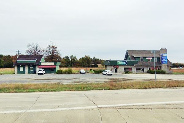
Turn right along an access road that runs on the east side of S. Elliston Rd. map, it takes you to a former cafe and gas station built in 1955 next to where the "new" westbound lanes of the divided highway had been built, on the south side of the future eastbound roadbed.
See it in this Aerial Photo from 1955.
Below is the current appearance of the site, but it has been cut off from the old four lane alignment, when it was upgraded to Interstate standards and was no longer a divided highway with grade crossings.

The buildin on the right was the Cafe, now it is a store. The one on the left was a garage-gas station. The two green panels on its facade mark the service bay doors.
This is also the end point of your Road trip through Hofflins, keep on driving westwards and continue your trip in Cuba.

Some sponsored content
> > Book your Hotel in Lebanon

Credits
Banner image: Hackberry General Store, Hackberry, Arizona by Perla Eichenblat
Jack DeVere Rittenhouse, (1946). A Guide Book to Highway 66
Show me Route 66 (Winter 1997) issue.

