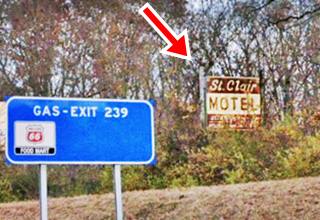
Route 66 in St. Clair
Index to this page
About St. Clair Missouri
Facts, Trivia and useful information
Elevation: 769 ft (235 m). Population 4,724 (2010).
Time zone: Central (CST): UTC minus 6 hours. Summer (DST) CDT (UTC-5).
St. Clair is a city on Route 66 in Franklin County, in the central-eastern Missouri.
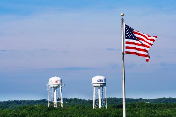
Hot and Cold water towers in St. Clair Missouri
History of St. Clair
Eastern Missouri was peopled at the end of the last Ice Age around 10,000 years ago by the first Americans. Much later, the local Native Americans that lived here were an Algonquin nation known who called themselves "Illiniwek" which meant "men"; they were hunter-gatherers and also grew crops of beans, corn and squash. Explorers from the French colony in Canada reached the area in 1683 and claimed it for France, naming it Louisiana (after their King Louis XIV). They called the natives by a deformed version of their name: "Illinois". France lost the territory to Spain, and the Spanish explored the area, returning it to France in 1800. Napoleon Bonaparte, needing cash, sold it to the US in 1803, who organized the Missouri Territory in 1812.
Franklin County was established in 1818 and was named after Founding Father Benjamin Franklin. Missouri was admitted as a state in 1821.
In the 1830s, the Illinois were forcibly relocated together with all the other Natives that had lived east of the Mississippi to reservations in what is now Oklahoma. This opened the way to white settlers in the region who cleared the forests and established their farms. The first to settle here was B. J. Inge in 1843 and the place was known as "Taveler's Repose" until 1859, when the local residents decided to change the name to "St. Clair", It was in 1859 that the town was platted and was the railroad terminus.
The Name: St. Clair
Named after a the engineer of the St. Louis and San Francisco or "Frisco" Railroad who lived there; some say that they changed it from "Traveler's Repose" because that name sounded like some kind of cemetery or tavern. The surname comes from a Catholic saint, St. Clair of Tours, monk at Marmoutier Abbey in Tour, martyr in 397 AD. Clair in Latin "Clarus" means pure, clear.
The main road from Springfield to St. Louis, known as the "Wire Road", which ran next to the military telegraph passed through the town. Later this road would be the basis for Missouri State Highway 14, and in 1926 Route 66 was aligned along it. The town got good business from those travelling along Route 66. But in the early 1950s Route 66 was too congested and, all through Missouri it was moved out of the towns and cities, bypassing them. Saint Claire was no exception, and US 66 became a four-lane highway which went along its western flank.

Where to Lodge in St. Clair, Missouri
There are several motels in Saint Clair, you can find your accommodation here.
> > Book your Hotel in Saint Clair
More Lodging near St. Clair along Route 66
There are several hotels in the area close to this town. Alternatively you can also find your accommodation along Route 66 in the neighboring towns and cities in Missouri. We list them below (from east to west):
On Route 66's Main alignment in MO
Eastwards
Westwards
- Hotels in Kansas
- Baxter Springs KS
- Galena KS
- Riverton KS
- Hotels in Oklahoma
- Miami OK
>> Check out the RV campgrounds in neighboring Stanton
Weather in St. Clair

Location of St. Clair on U.S. Hwy. 66
St. Clair has well defined seasons, because it combines wet continental and humid subtropical climates.
The winter (Jan), the average high is around 39°F (4°C) and the aveage low is a freezing 21.8°F (-5.7°C). The summer (Jul) average high is 88°F (31°C) with an average low of 68°F (20°C). Rainfall averages 43 in. (1.092 mm) yearly and takes place during some 90 days each year. There are around 205 sunny days yearly. Snowfall is around 12.8 in. (32.5 cm), which falls from Dec. to Mar.
Tornado risk
St. Clair is located in Missouri's "Tornado Alley" and Franklin County is struck by some 7 tornados every year.
Tornado Risk: read more about Tornado Risk along Route66.
Map of Route 66 in St. Clair
Coming from Villa Ridge, the 1926 alignment runs on the north side of the freeway (I-44), as it approaches St. Clair it is cut by the Interstate and there is a missing segment on the eastern side of Exit 242, and at the interchange of the exit. Route 66 continues as the South Frontage Rd. see this map (purple line) with the missing and extant alignments.
Route 66 was realigned in St. Clair
St. Clair's first alignment was unpaved and followed the Springfield Road. It was paved and realigned in 1927 with a diagonal course between Sincox St. and Walnut St., where it met MO-30, as shown in this map (violet line). The black lines in the map show the streets that were later eliminated or cut off: Maple and W. Oak streets are now cut off on the western side of the present alignment of US 66, but in those days continued east, crossing Commercial Ave., which ran straight southwards, ending at the junction of Walnut St. and Gravois Ave. The two stunted forks of S. Lay Ave. which now have dead ends to the east of current Commercial Ave. both reached it in those days.
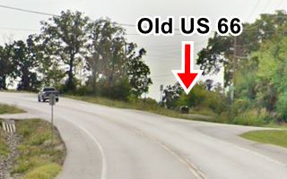
Later during the late 1950s, Route 66 was realigned where I-44 is now located. The present alignment of "Historic Route 66" was built in 2009, abandoning the old Route 66, a portion of which can still be seen at the dead end of W. Oak St., to your right, on the west side of the highway (see image looking west, red arrow).
South of St. Clair the original Route 66 can be driven for 1.5 miles before it reaches I-44 which cut it off. See this map South of St. Clair.
The original roadway is overlaid by I-44 after that point map (gray line) and resurfaces on the South Service Rd for a short stretch (map), before swinging to the north (cut by I-44, second gray line in the map) to follow a wide arch between Wildwood Estates Rd. and Tag-A-Long Rd (map of this arch).
Route 66 in Downtown St. Clair
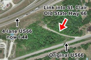
When the four-lane highway was built in the early 1950s, the modern State Highway 30 didn't run along its present alignment towards Exit 239 (marked with a blue-dashed line in the thumbnail map below - click on it to enlarge it), it followed what is now known as "Old State Highway 66", marked with a yellow arrow in that same map, and also shown in the satellite view below (red arrow). This linked the new 4-lane alignment now overlaid by the freeway with the original 1926 US 66 alignment in St. Clair. This original US 66 can be seen entering the town (blue arrow right) and leaving it next to the Frisco railroad (red arrow bottom).
The Route 66 alignment in St. Clair
Visit our pages with old maps and plenty of information about US 66's alignments.
- Rolla to Springfield (next)
- Gray Summit to Rolla (in St. Clair)
- Route 66 in St. Louis (previous)
Route 66 Sights in St. Clair
Landmarks and Places to See
Historic context, the classic Route 66 in St. Clair
The travel guide published in 1941 by the WPA ("Missouri, a guide to the "Show Me" state") describes it as a peaceful town with "... red-brick stores and rambling frame residences typical of rural trading centers."
Jack DeVere Rittenhouse in his "A Guide Book to Highway 66" published in 1946 tells us the following:
gas; garage; Commercial Hotel; Johnson's Mo-Tel... US 66 passes town on the west edge... it is a peaceful town, full of sedate old residences Rittenhouse (1946)
Sights and Stops in St. Clair
Hall's Place
Start this leg of your road trip, driving west from Villa Ridge. Five miles east of St. Clair is an old gas station, Hall's.
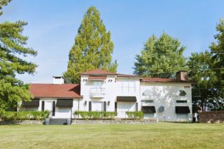
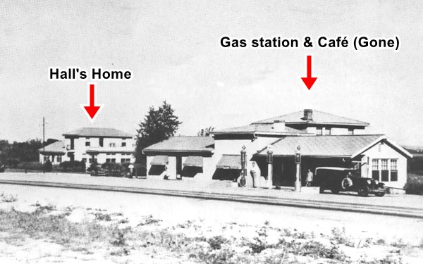
To your right, on the top of a low hill, you will spot a two-story hip and gable roof home. This was the home of Frank Hall, who owned the adjacent Mobil gas station. The place later became Hilltop Café but the station and cafe were torn down when the North Service Road of the freeway was built. Only Frank Hall's home survived (see image with current view of the place and the vintage picture below).
Head west, 3.5 mi east of St. Clair you will come across a weird stop on the North Service Rd. with very nasty reviews but good for a picture if you dare stop after reading the reviews and are willing to pay an entrance fee.
Indian Harvest Trading Post
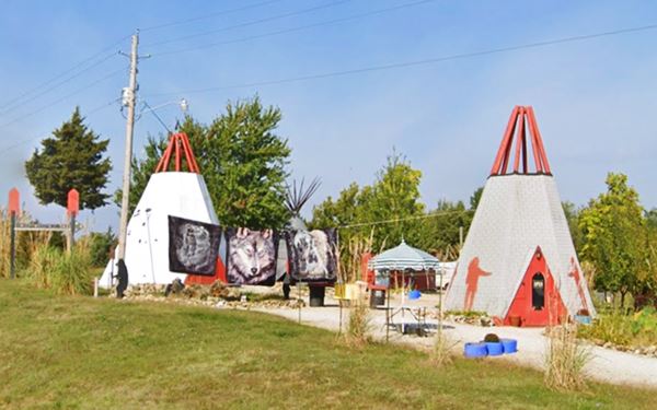
At 1245 N Service Rd W, St. Clair. It opened around 1996, and is a "modern" landmark. See its Trip Advisor ratings (1.5 stars out of 5, with 49 reviews) which is quite discouraging. We mention the spot bcause it seems to be a typical Route 66 kitsch-wacky site, with Indian teepees.
The post is located where the old Route 66 meets the freeway, becoming its north Service Road. Originally it continued straight and curved on what is now the south side of the freeway as shown in this map (purple line). So, just ahead, at Exit 242 you will have to cross the freeway to its southern side to follow the old alignment.
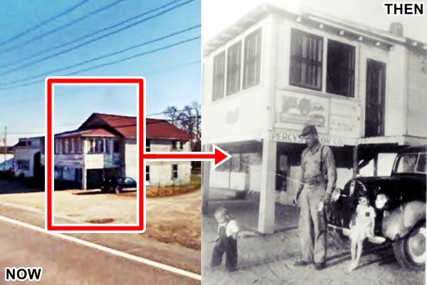
Route 66 becomes N. Commercial Ave. as your approach the town, to your left, at 1236 is an old garage, Percy's.
Percy's Motor Co.
Percy Dickinson owned the garage and a used car dealership, whose postcard announced "Percy's Motor Co. -- St. Clair, MO -- Phone 43 --- Used Cars & Parts. Ferguson Tractors & Implements." You can see it in this aerial photograph taken in 1945 (lower left).
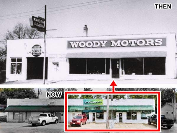
Edgar Murray Station - Woody Motors
Drive 0.4 mi west, and to your left, at 810 N. Commercial Ave.the long white brick building (only the western wing; the eastern one was built in 2006) was a garage, known as Woody Motors, that offered Kaiser-Frazer service (the car manufacturing company was known under that name from 1947 to 1953). The place started as a tractor garage and gas station owned by Edgar Murray. Later it became Harry Brown's body shop. Below is a composite "Then and Now" view of the site:
Johnson's Mo-Tel Cabins
Next to Woody's, also to your left, at 780 N Commercial, the gable roof, stone cottage-like building housed the office of the motel and restaurant owned by Charlie and Liza Johnson unitl 1952 when the moved to the new Route 66 four-lane alignment and operated the Skylark Motel. It also had a service station, the pumps located in front of the building. The cabins -now gone- were on the back of the property next to N. Main St.
It dates back to 1940 and its post card says it offered "Home Style cooking", it was briefly renamed "Art's Motel" but reverted back to its original name.

1940s postcard Johnson's Mo-Tel Cabins, US 66. St. Clair. Source
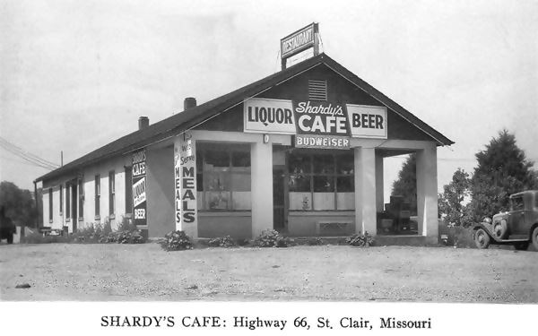
Shardy's Cafe - Hi Spot Inn

1950s Hi Spot Inn, US 66. St. Clair. Source
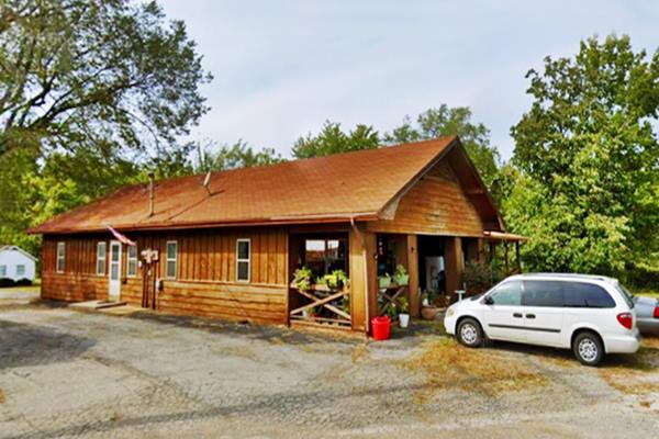
Ahead, 0.2 mi. west, at 557 Historic Route 66, on the right side of the highway. It sold liquor, beer and offered meals. The long, one-floor, gable roof building is still standing, with the same four sturdy pillars holding up the front porch.
The building also housed the Hi-Spot Inn, a Cafe (1950s), which got its name from its location, on the top of a hill on Route 66. , it became a private property "Hi-Spot Apartments".
Below is a "Then and Now" set of images.
Next to it, in what is now the "Old Bus Stop Art Gallery", was the old Greyhound bus stop.
Short side trip: Take a left along Kitchell Ave. to Main St. (0.2 mi) to visit a historic site.
The International Shoe Company Building
Listed in the National Register of Historic Places
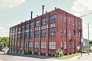
160 N Main St. On the SE corner of Main and Park Ave. The International Shoe Company closed in 1983 but for 60 years was the largest employer in St. Clair. The three-story building was built in 1922 (in 1926 what is now Main and originally was Springfield Rd., became Route 66 for one year). Retrace your steps to Route 66, and turn left. Continue west for half a mile, to your right at Sincox St., is where the original Route 66 forked off its present alignment (we explain this further up). Take the new alignment till you pass MO-30. To your left is another classic landmark.
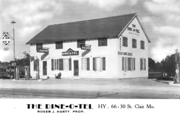
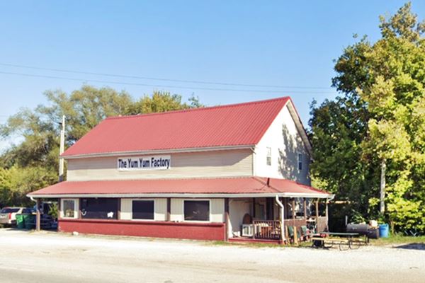
The Dine-O-Tel
To your left, a two story gable roof building. It was ran by Roger Harty, and offered rooms on the top floor, liquor, and food; with a Skelly station next to it. Below is a Then and Now sequence, same building over the course of 85 years (according to Quinta Scott, it opened in 1937).
Route 66 continues straight, and is cut off by the freeway 1.4 miles further west, and has a dead end. But there are two sights along it:
Keep westbound and just where Route 66 takes a right towards the freeway, ahead to your right you will see a classic Automobile dealer:
Ritter Motor Co.
At 401 Commercial St. it began as a gas station, garage amd some cabins, ran by Ritter and Berkel, the site was known as "Shady Shell Park". Later they began a scrap yard salvaging old cars and selling some as scrap. Listen to Jerome Ritter talking about this place, in 2017.
The red brick building was built in different periods and served as a Chrysler automobile dealer, named Ritter & Sons Inc. selling Chrysler and Plymouth cars. It dates back to 1927, one year after Route 66 was created and was modified in 1931, 1947 and again in 1949. This was the original 1926-1950s original Route 66 alignment on the western side of St. Clair.

Shangri-La motel c.1960, Route 66 St. Clair. Source
Site of Shangri-La Motel
Continue west along the old Route 66, you will pass the site of the now razed "Shangri-La Motel" (1964 aerial photo). The image above shows it as seen looking west from the 4-lane US66 eastbound lanes.
Continue westbound, and 0.6 miles west of Ritter's is the classic St. Clair Motel:
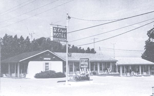
St. Clair Motel
620 W Springfield Rd, to your right. Map showing location
Built in 1943 it is a one-story wood-frame structure with a linear layout with a gabled roof and a porch overhang. It was owned by Pete Krifka and his wife. The original building had 2 units and later, in 1948 another 8 units were added. It was bypassed when Route 66 became a four-lane highway, and realigned on the north side of the motel, just behind it, in the early 1950s but it still had access to it (unlike modern freeways, the 4-lane 66 had unlimited access). Later it was owned by Fred and Mary Leen, the Crumbackers, and by the Reeds in the 1960s. I-44 cut it off definitively in the 1970s, yet they placed a neon sign facing the freeway (see image).
The bypassed 1926 Route 66 ends just ahead. Turn around and head back to St. Clair, take a left on Hwy 30 (Historic Route 66) and cross the freeway at Exit 239.
Arch Motel - Gone

Arch Motel neon sign, Route 66 St. Clair. Click for St. view. Source
In case you are wondering where was the famous Arch Motel, with its "mini" replica of the Gateway Arch in St. Louis, it was located on the SW corner of Davis St. and the N Service Rd W., at 410 W Davis St., at this spot (see map). Arch and motel have been torn down.
Skylark Motel
At the overpass, turn left and drive along the North Service Road for roughly 1.3 miles to Hwy WW, to your right, at 2150 North Service Rd. on the NW corner of Co. Rd. WW.
Charlie Johnson, owner of Johnson's Mo-Tel Cabins foresaw a drop in business once the new four-lane alignment of Route 66 was built. So in 1952 they opened a new motel on the brand new super highway.
The concrete block motel is a two-story building in a Streamline Moderne - International style, with a glass and concrete corner that juts out towards the highway built in
a beautiful curved "fin" Streamline Moderne style. It was cut-off from the highway when Route 66 reached Interstate level, it had to readapt in the late 1960s to other uses.
The glass blocks were lit up from behind with neon lights.
It was bought in 1993 by the Veterans of Foreign Wars (VFW) who worked with the Route 66 Association of Missouri’s Neon Heritage Preservation Committee to restore the
tower and sign to its original appearance. Across the street (Co. Hwy WW) is a classic "Motel and Restaurant":

Neon sign at the Skylark Motel, Route 66 St. Clair,
Source
Scully's Sunset Inn

Scully’s Sunset Inn, old postcard, Route 66 St. Clair. Source
At 1095 N Service Rd W. It was a 1920s classic service station, Inn, and restaurant. In its postcards it announced itself as an "AAA Approved, Restaurant, Hwy 66, 2 miles west, St. Clair Mo".
Its original location was closer to where the freeway is now located (here is where the original alignment of Route 66 "resurfaces" on the north side of I-44 coming from the St. Clair motel). When the 4-lane alignment was built in the 1950s, it was moved a couple of hundred feet further north.
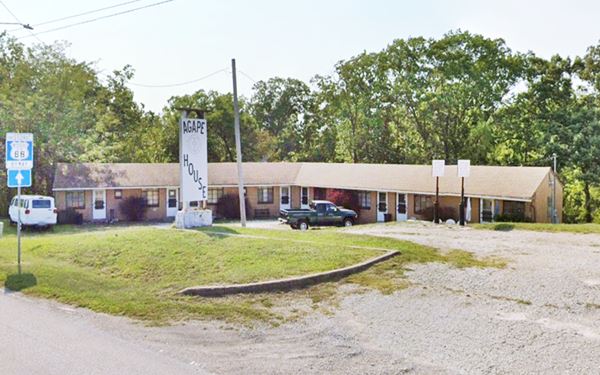
It closed, and after 17 years vacant, reopened as a charity, Agape House Hunger Line; agape is a Greek word meaning "loving someone like a friend".
Compare its "Now and Then" views: the building is relatively untouched, the eastern section where the gas pumps once stood, now have a gabled roof, and the entrance of the building on the western side has been closed in.

Unnamed motel
Next to it, on its western side, is another Motel from the 1950s, which we have not managed to identify by name:
1950s Motel
It has an "L-shaped" layout; a motel with eight units, dating from the early 1950s on the four-lane US 66, it now has no signs to identify it other than the stump of the original neon sign. It was probably part of Scully's as its only entrance is linked to the old Inn. Now it is also part of the Agape charity.
New England Pantry
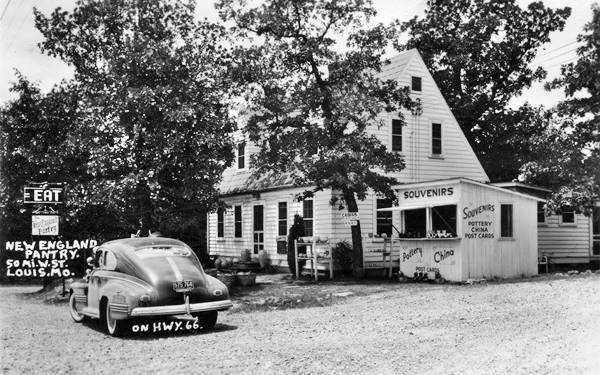
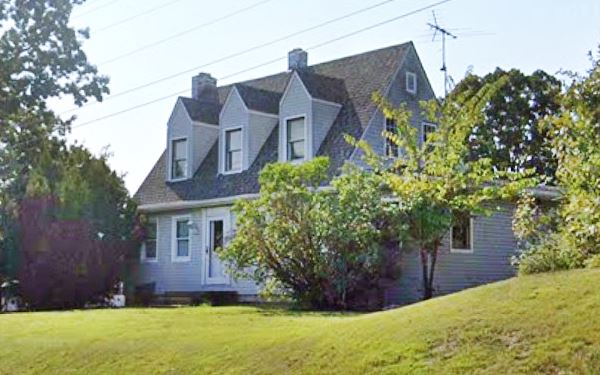
Head west for 0.6 mi. To your right, at 1313 Route 66. Now a private home, it began as a private residence that became a restaurant, its main dish was clam chowder and it was operated by John Franklin Mueller andd his wife Cecilia nee Thake. Cecilia did the cooking. They also had some cabins that they rented, next to the restaurant. The family lived on the second floor. When the freeway was built it cut the place off from its customers. See its then and now picture. Now it is a private home again.
A Cape Cod style home: rectangular two-story, steep pitched shingle roof, with gables on a wood frame cottage, with chimneys.
Continue westwards for 2.2 mi. along the service road (US 66) and just after the old road moves away from the freeway, is the final Route 66 Attraction in town:
Meramec Caverns Barn sign
5.1 mi. west of St. Clair, on Historic Route 66, Map with directions
As part of a vast advertising scheme, Lester Dill painted barns over most of the midwest, spanning 14 states with his "Meramec Caverns" barn signs. Read more about this attraction, the Meramec Caverns in neighboring Stanton, Missouri which still draws 150,000 visitors each year.

You can see some of the other surviving barns on Route 66 in Conway MO and Chandler OK just to mention a few of them.
Continue your Route 66 Road Trip westwards driving towards Stanton.

Some sponsored content
> > Book your Hotel in Lebanon

Credits
Banner image: Hackberry General Store, Hackberry, Arizona by Perla Eichenblat
John Muller bio
Jack DeVere Rittenhouse, (1946). A Guide Book to Highway 66


