"Cuba: Where History Meets Art"
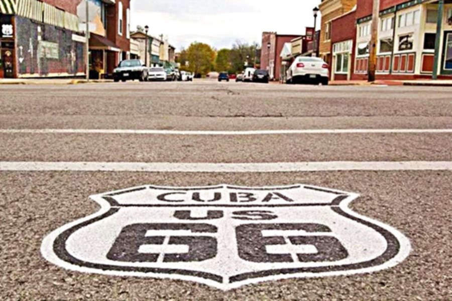
Shield on an intersection in downtown Cuba Missouri
Index to this page
About Cuba Missouri
Facts, Trivia and useful information
Elevation: 1,001 ft (305 m). Population 3,356 (2010).
Time zone: Central (CST): UTC minus 6 hours. Summer (DST) CDT (UTC-5).
Cuba is the largest city in Crawford County, but it is not the county seat (Steelville is the county seat). It is located on Old Route 66, in the central Missouri Ozarks foothills.
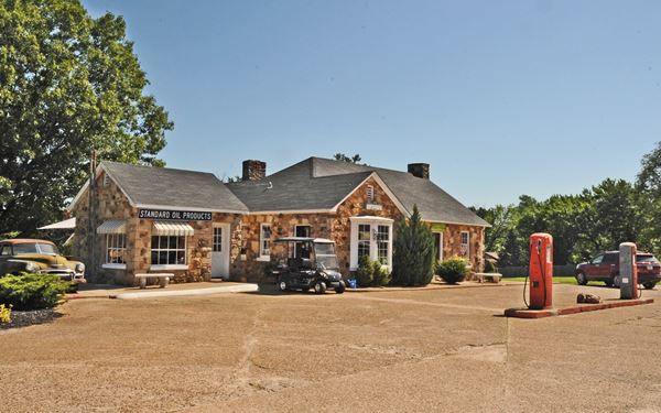
Historic Wagon Wheel Motel, Route 66 in Cuba, Missouri
History of Cuba
Central Missouri has been inhabited for over 10,000 years, since the last Ice Age ended. The historic people in this region were an Algonquin nation known as "Illinois" (deformed from the name they called themselves: "Illiniwek" which meant "men"). French trappers and explorers from Canada claimed the area for France in the 1680s, and named it after their ruler, King Louis XIV: "Louisiana". In 1763 France ceded the upper Louisiana to Spain and recovered it in 1800. But a cash-strapped Napoleon sold it to the U.S. in 1803. Part of Louisiana became the Missouri Territory (1812). It was admitted as a state in 1821.
In the 1830s, the Illinois, who were hunter-gatherers and squash, beans and corn farmers were relocated together with all the Natives that had lived east of the Mississippi to reservations in the Indian Territories (which later became the state of Oklahoma). But by then, there were already White settlers in the area: William Harrison had arrived in 1821. James B. Simpson settled on a flat grassland named after him: Simpson's Prairie in 1837. Crawford County, was organized in 1829 and named after U.S. Senator (Georgia) William H. Crawford, George M. Jamison (1818-1873), a native Kentuckian also lived in the area by 1840, half a mile from where Cuba would be founded in 1857 by M. H. Trask and William Ferguson who platted it in Simpson's prairie, along the railroad's future course . The Frisco Railroad reached Cuba in 1858 and the town became a farming community.
The Name: Cuba
The first post office was named Amanda (after Jamison's wife), but when the post office moved in 1860 to the new town, it was renamed Cuba perhaps due to the political feelings of those days which claimed for an annexation of the island due to its status as a Spanish colony (in 1898 the US won a war against Spain and annexed Cuba and Puerto Rico. Cuba later became independent, but Puerto Rico is still part of the US). However, according to the WPA it was named "by two former gold miners from California, who wished to perpetuate the memory of a holiday they had spent on the 'Isle of Cuba'."
From 1926 to 1969, while Route 66 went through Cuba, the travelers gave the local economy a boost, and motels, cafes and gas stations were built to cater to them. In 1969, Route 66 a full fledged divided highway bypassed the town.

Find your hotelin Cuba, Missouri
Cuba has a fair assortment of lodging options, so you can stop over here if you choose to do so.
> > Book your hotel in Cuba
More Lodging near Cuba along Route 66
There are several hotels in the area close to this town. Alternatively you can also find your accommodation along Route 66 in the neighboring towns and cities in Missouri. We list them below (from east to west):
On Route 66's Main alignment in MO
Eastwards
Westwards
- Hotels in Kansas
- Baxter Springs KS
- Galena KS
- Riverton KS
- Hotels in Oklahoma
- Miami OK
>> Check out the RV campgrounds in Cuba
Weather in Cuba


Location of Cuba on U.S. Hwy. 66
Cuba has well marked seasons, which are the combination of humid continental and humid subtropical climates. The winter (Jan), the average high is around 39°F (4°C) and the aveage low is a freezing 20°F (-7°C). The summer (Jul) average high is 89°F (32°C) with an average low of 68°F (20°C). Rainfall averages 44.5 in. (1.130 mm) yearly which ranges from 2.21 in (56 mm) in Jan. to 4.81 in (122.2 mm) in May. Snowfall is around 18.9 in. (48 cm), which falls from Dec. to Mar.
Tornado risk
Cuba is located in Missouri's "Tornado Alley" and Crawford County is struck by 7 tornados every year. Tornado Risk : read more about Tornado Risk along Route66.
Route 66 map and alignment in Cuba MO
Route 66 originally ran along State Highway 14, and Man St. into Cuba. Arthur Eads (Source: Show me Route 66) recalled in 1996 that
"Main St. [was] original 66 in Cuba. It was 1927... until the "new" 66 (Washington) was paved in 1928". The whole dirt road was finally paved by 1931.
On the eastern side of the city, Route 66 forked at a "Y" junction, away from Springfield Rd. which went along Main St., while Route 66 went along Washington St.
According to Missouri States Parks and the National Parks Service, the hotels on Main Street built new fronts facing Washington St. (Route 66) to attract the new customers that drove along Route 66.
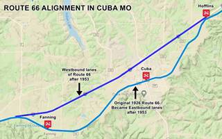
Starting in the early 1950s Route 66 became too congested in the neighboring town Cuba. So it was upgraded to a four-lane highway in which the original 1926 Route 66 alignment through Hofflins became the two eastbound lanes of the new "super highway" between Hofflins and Fanning (Pale Blue in the map below). Two additional new lanes were built (shown in Blue in the map below - click thumbnail image to enlarge) from what is now Exit 203 to Exit 210 at Hofflins to carry the westbound traffic. This is the map of the 1926 Route 66, later the EB lanes, from Hofflins to Fanning through Cuba.

USGS map of Fanning to Hofflins through Cuba 1966, Route 66 is shown in Red.
The Route 66 alignment in Cuba
Visit our pages with old maps and plenty of information about US 66's alignments.
- Rolla to Springfield (next)
- Gray Summit to Rolla (in Cuba)
- Route 66 in St. Louis (previous)
Route 66 Sights in Cuba
Landmarks and Places to See: Cuba and its Route 66 attractions
Historic context, the classic Route 66 in Cuba
"Missouri, a guide to the "Show Me" state" a guide published by the WPA in 1941 tells us about its origin and its name, and that "...its business center [was] slowly abandoning a location near the railroad tracks for a new one on US 66".
The 1946 book by Jack DeVere Rittenhouse however ("A Guide Book to Highway 66") mentions some of its motels and garages:
... garages: Souder's and Square Deal; hotels: New Central and Cuba; cabin courts: Wagon Wheel, Barnsall, Red Horse Tavern ... [Cuba is an] important highway town Rittenhouse (1946)
Sights in Cuba
Begin your tour on the eastern side of town, where old Route 66 forks to the right along Washington St. leaving Main St. that runs next to the railroad. Just west of Fleenor Rd. on the right side of Route 66 once stood the "Lazy Y Camp" named after the fork.
It had cabins and a Phillips 66 gas station.
At the "Y", to your left was another cabin complex, the
Red Horse Cabins
Their postcard said: "Sleep in safety and comfort at reasonable prices. All strictly modern cottages, steam heated, free garages... Owned and operated by Mr. and Mrs. C. C. Cox.." Mentioned by Rittenhouse in 1946 as a "Red Horse Tavern" among the town's "Courts". The complex opened in 1938 and had a Mobil gas station, cafe, and cabins on the eastern side of the property with their backs to the tracks and old Main. It later grew into a truck stop ("Largest truck between St. Louis and Springfield"), fire razed most of the buildings in 1953. Some of the gable roofed cabins have survived (marked with a red arrow in the "Then and Now" image below.
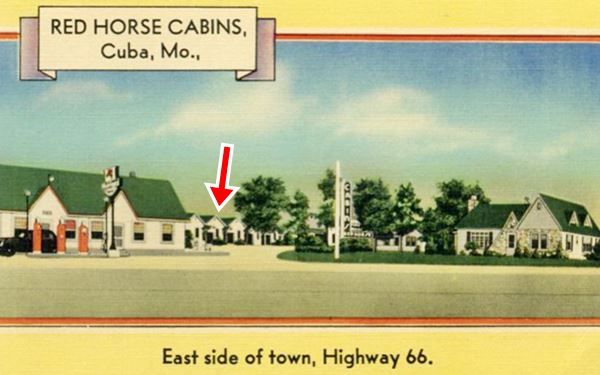
Route 66 runs on the right, Main ran next to the tracks. This view looks west.
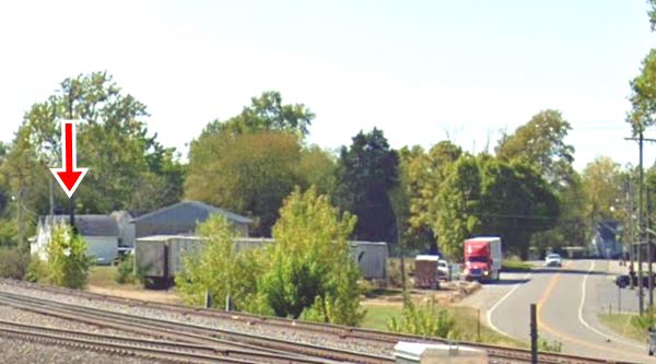
Annex Cafe (Missouri Hick Barbeque)
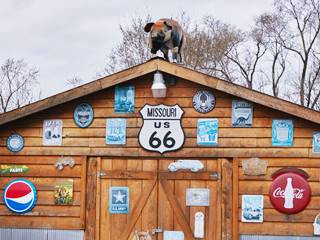
Pig on rooftop, Missouri Hick BBQ, Cuba. Source
Across the road, to your right was the "Annex Cafe", now "Missouri Hick Barbeque". At 913 E Washington St. The first building here opened in 1944 as the "Wagon Wheel Annex" named after the Motel to its left. In 1946 its new owner, Paul Killeen renamed it "Paul's Cafe".
It included a Phillips 66 station (Cooke Service). It closed when the new four-lane alignment bypassed downtown Cuba in 1960.
Missouri Hick BBQ is a "modern" landmark, it opened in 2002. Don't miss the hog on the roof's ridge.
Wagon Wheel Motel, Cafe and Gas Station
Listed in the National Register of Historic Places
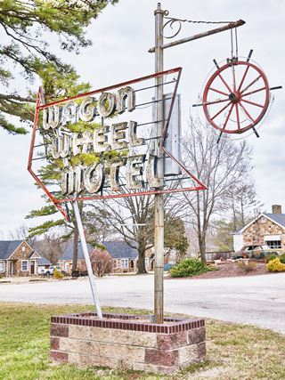
Wagon Wheel motel neon sign, Cuba. Source
Adjacent to the old Annex Site is the Wagon Wheel Motel. At 901 E. Washington St., to you right. Still open and lodging guests (Read more at their website). It is pictured above at the top of this page. Robert and Margaret Martin bought the property in 1934 and had Leo Fiesenhan design the buildings. He used local sandstone for the Tudor style cabins: three, each with three units and garages. They have gabled roofs and arched doorways and offered "private tub or shower bath... gas heat; fans in summer; enclosed garages". The Wagon Wheel Cabins, as they were known then, opened in 1936.
As traffic grew the garages were converted into units and after WWII the Martins split the business and sold it. The Cafe and station was taken over by Sadie Mae Pratt.
John and Winifred Mathis bought the cabins in 1947 and renamed them "Wagon Wheel Motel" adding a laundry and another concrete lodging building with 4 units. The famous neon sign (see image) dates back to 1947 and was designed by John Mathis.
The old gas station and cafe are currently a gift shop and motel office. Continue westwards along old Route 66 and take a left on the second block along N. Clay St.
At the junction with Main Street you will see two classic Route 66 hotels that were built here because the town's railway depot was here, by the tracks but later adapted to Route 66 running behind them, along Washington St.
Southern Hotel
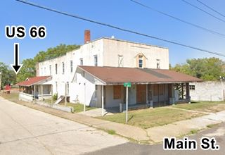
As you approach Main, the hotel is to your left, at 601 E. Main on the NE corner of N Clay was the Southern Hotel. Across the street (N. Clay St.) from Hotel Cuba (to your right). It was where Bette Davis stayed when she visited town in 1948 (that visit is depicted on the Bette Davis mural).
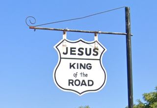
On the now vacant lot behind the hotel (along Washington St.) was the Barnsdall Service Station and cabins (a long unit against the hotel's western wall). Now a "Jesus King of the Road" shield marks the spot.

1940s postcard, Southern Hotel, Cuba, MO. Source
Hotel Cuba
Listed in the National Register of Historic Places
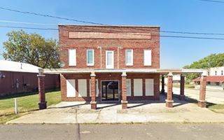
Located at 509 E Main, on the NW corner with N Clay. Hotel Cuba was built in 1915 and was originally named "Palace Hotel". It catered to those traveling by train to Cuba. When Route 66 was aligned behind the hotel along Washington St. and paved in 1928, the hotel was completely rebuilt and moved its main entrance to face the highway and reinvented itself as the "Hotel Cuba" taking car of the automobile clientele. Rittenhouse mentioned it in 1946. Below is a "Then and Now" view, the 1940s postcard shows the now gone entrance on Washington St.
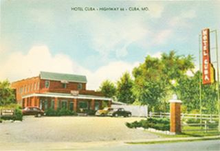
1940s postcard, Hotel Cuba. Source
Westwards into Cuba
Return to Route 66 and turn left along Washington St. to your right is one of Cuba's murals.
Mural City
The "Uptown Cuba Historic District" is listed on the National Register of Historic Places; and the Missouri legislature designated Cuba as the Route 66 Mural City recognizing the merits of "Viva Cuba's Outdoor Mural Project" which guided by the advice provided by a renown Canadian muralist, Michelle Loughery helped outline this project and actually painted two of the twelve murals on Route 66 corridor; they tell Cuba's history from 1857 and its link to US 66. We will list them along your tour.
Mural #1 "Bette Davis Mural"
On the facade of the red-brick building at 501 E Washington St.
The mural depicts the moment local reporter Wilburn Vaughn took a photo of actress Bette Davis (1908 - 1989) winner of two "Best Actress" Oscar awards, and her husband during their Nov. 1948 visit to Cuba.
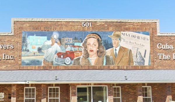
There is a marker on the left side of the building explaining the circumstances of the event pictured in the mural (Vaughn was chased by Bette Davis' husband after he took the shot and fell flat on his face in the mud!).
We will describe the sites along Route 66 in this area, (click on the 1930s thumbnail image below to see full size picture.
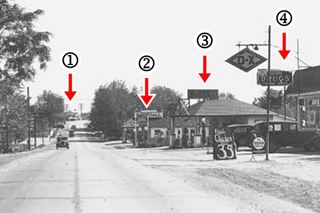
Looking east along Route 66 1930s.Source
Click on thumbnail to see large image
The old black and white photo from the 1930s looks east along Washington St. in the distance (1) is the Wagon Wheel Motel. Closer, (2) is the now gone Barnsdall service station, with the name "Barnsdall" across the canopy. Next, (3) is the old Ever Ready ⁄ Kimberlin station, and finally, (4) the Drugstore, we describe these last two below. This is that same view along Route 66 nowadays.
Kimberlin Bros - Ever Ready gas station
Marked with (3) in the thumbnail, it is still standing, though very altered, on the SE corner of Washington and St. Laurence St. The filling area under the hip roof canopy has been enclosed, but the two columns that hold it up are still clearly visible. Compare the following vintage images with its current street view. It changed names several times: Kimberlin Bros, Mobile station, Ever Ready Filling Station, selling Mobil gas, a Shell in the 1950s.
Notice the Southern and Cuba hotels in the background
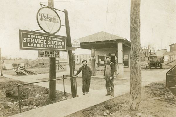
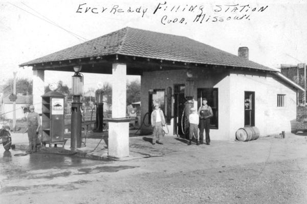
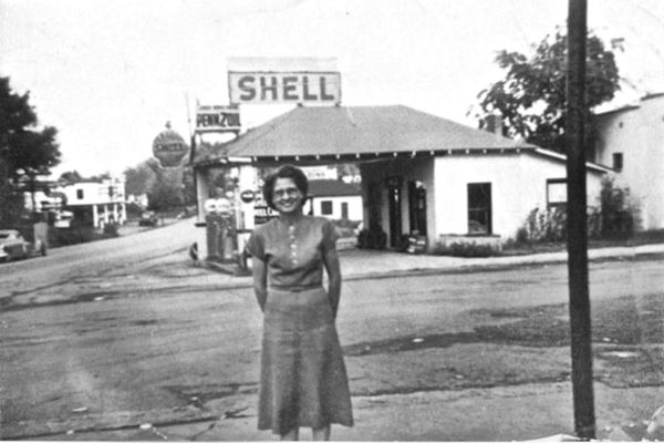
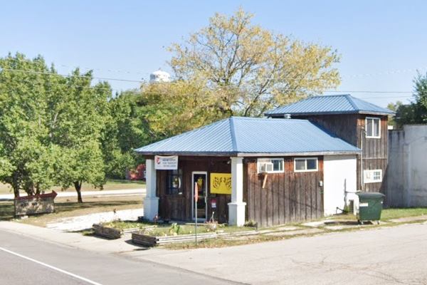
Click for street view
The back part of the station has been altered into a two-story structure.
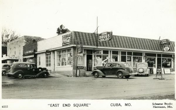
Former East End Square Drugstore
Marked with (4), it is located on the SW corner, opposite Kimberlin Station, now it is the "East Office Bar-N-Grill", but at one time it was a drug store and a cafe, the "East End Square", the thumbnail image further up shows that in the early 1930s it also sold D-X gasoline. The image below, taken later also shows the old Cinema (right side of the image). The Drugstore has been altered, but the old movie theater is still standing, see the "Then and Now" sequence below.

Shelly's Route 66 Cafe
Just ahead, at 402 E. Washington on the SW corner with S Lawrence St.
When it opened back in the 1950s, it was Cuba Dairy Cream, and now is Shelly's Route 66 Cafe. A classic eating spot in Cuba, it is pictured below. Visit their Facebook.
Mural #2: Al West
To your left, at 298 E Washington St. A false front of a building painted with a mural depicting former Mayor, Al West Sr.
West was Cuba's mayor from 1946 to 1958, he modernized the city and attracted industrial investments, creating jobs.
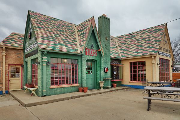
Continue west to the main intersection in Cuba: Franklin and Washington (MO-19 and old 66). Here, ahead, to your left, on the SW corner is an iconic Cottage style Phillips 66 filling station.

Phillips 66 Gas station
106 W. Washington on the SW corner of Hwy. 19 (Franklin) and Route 66.
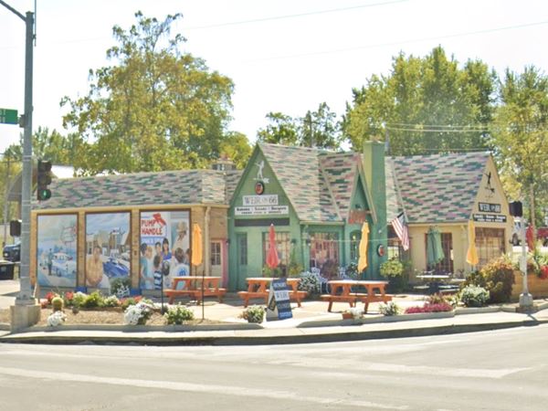
Built by Paul T. Carr in 1932 who ran it until his death in 1964. The service station is a typical cottage style 1930s service station. It had two separate pump bays, with three pumps each, facing Route 66 and MO-19 respectively.
The multi-colored roof tiles were a marketing feature of Phillips 66. Notice the "P" (for Phillips) badge on the chimney in the 1960s picture below and in this
2021 street view.
Below you can see it in the late 1950s or early 1960s (Paul Carr is on the right) it sold Mobil gas at that time.
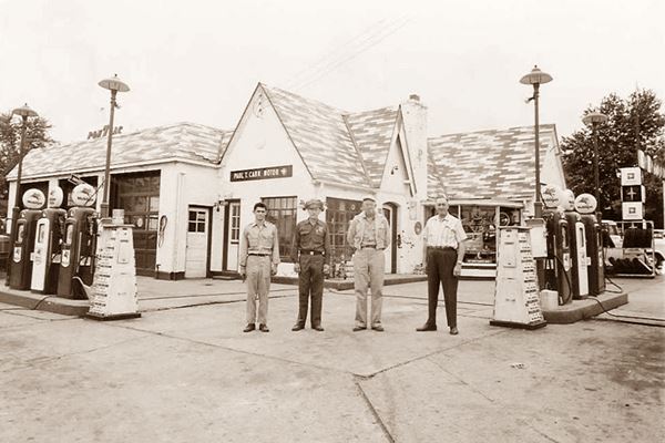
In 1968 Bill Wallis bought it by then it sold Mobile branded gasoline, he also made it the first office of his Wallis Oil Co. (which now has 600 employees).
2021 View of the Phillips 66 Gas station in Cuba Missouri. The Mural panels are on the far left.

Wallis & State Hwy Patrol Mural. Source
Click image to see full size picture.
Mural #3: Wallis and the State Hwy. Patrol
On the Service Station, facing Franklin St. The doors of the three service bays on the left became murals: There are three panels which cover the former service bay doors, portraying Bill Wallis and the 75th anniversary of the Missouri State Highway Patrol.
The Cuba City Jail or Calaboose

Cuba Jail built in 1908, Source
Listed in the National Register of Historic Places
Now, you can take a small detour to visit the "Calboose", take a left along S Franklin St. go through the underpass and visit the old Jail (0.3 mi.) as shown in this Map with directions.
SW corner of Prairie St. and S Main St., it is a one-story rectangular building made of concrete blocks built in 1908. It has the words "Cuba - Jail - 1908" on it. It has an iron door and was in use until 1954.
Other towns on Route 66 also have single-cell jails, read about them: Texola. OK jail, Foss OK, cage, and Gardner, IL, jail just to mention some of them.
Head back to Route 66, but continue straight along MO-19, cross the freeway and visit a memorial sculpture and a drive in theater (a 2 mile round trip - map with directions).
Osage Trail Legacy Monument
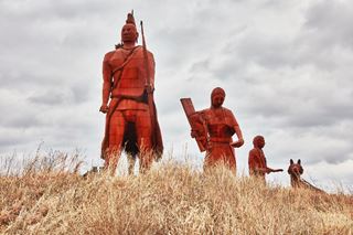
Osage Trail Legacy Monument, Cuba. Source, click for St. view
At Cuba Visitor's Center grounds, north side of the freeway, at the exit ramp onto MO-19. The sculpture is the work of artists Curtis and Glen Tutterrow and depicts a family of Osage natives trekking west after they were removed from their homeland in Missouri by the U.S. Government. It is 35 feet tall and 80 feet long, it includes an Osage warrior, his wife and daughter, and a domesticated red fox pulling a sled.
19 Drive-In Theater
Drive 0.2 mi west along state highway 19 to 5853 MO-19 and visit the old "19 Drive in", on Highway 19. It has been open since June 1955, and it was owned by A. P. Meier. From 1977 to 82 it was owned by D. R. Spreng. It reponed in 2005 with a capacity of 300 cars. Karen Spreng took a one-year break in 2021. Check its website 19drivein.com.
Mural #4: River Mural
Retrace your steps to Franklin and Route 66, one block north of Washington St., is another mural.

River Mural Source. Click for St. view
On the SW corner of W. Spencer Ave and N. Franklin St. The mural depicts a river. The Meramec, Huzzah, and Courtois rivers flow by Cuba and are used for fishing, having fun, and also used for transportation.
Ahead, on the next corner is the Cottage style Phillips 66 filling station described further up. Turn left and head west along W Washington St (Route 66).
Mural #5: Amelia Earhart
One block west, to your right, on the NW corner of N. Madison St and W Washington is another mural depicting Amelia Earhart (1897-1937).
She who was the first woman to fly solo across the Atlantic Ocean, had to make an emergency landing in Cuba in 1928 where she repaired her Avro airplane and continued her flight. She disappeared while flying around the world alone, in the Pacific Ocean and was never seen again.
Drive west for two blocks and to your left is the "Old Conoco Service Station":
Old Conoco Service Station
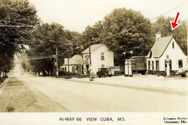
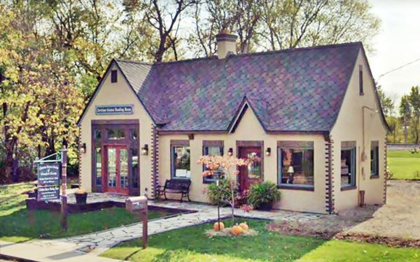
On the SE corner with S Filmore ST. at 306 W. Washington St. Now it is a Christian Science reading room, but at one time this was a Cottage-style Conoco gas station built between 1930 and 1940. The gas company adopted this Tudor revival style: steep gabled roof, a front facing gable over the entrance door, brick walls with sailorwork around the windows and door and brick quoins. A chimney and narrow vents on the end of the gable.
The garage on the left side of the property was added later, but maintained the same sytle, blended in with a cross gable to the main building as you can see in the "Then and Now" set of photos below:
Mural #6: Cuba Golde Star Boys
There is a mural painted on wall opposite the filling station across the street, on the SW corner. It depicts the Blue Bonnet Frisco train, a "special" that ran between St. Louis and Dallas⁄Ft.Worth TX. It is shown carrying young men to fight in World War II, "Cuba's Gold Star Boys".
Mural #7: Barnett
One block west, there are several murals painted alng the walls facing Buchanan Street between Washington and Main St. Starting at Route 66 you will see the "Barnett mural" showing Local Bank President, A. J. Barnett is depicted cranking his Ford model T, the first in town. The People's Bank building is still standing on the next corner.
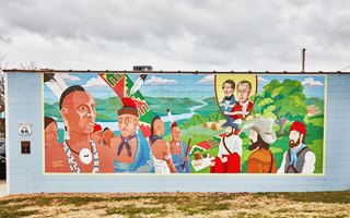
Osage meeting Mural, Route 66 Cuba. Click for large image. Source
Osage Meeting Mural
Next to Barnett's mural is another one, pictured above, the "Osage Meeting in Missouri" mural. It depicts Osage people meeting French trappers and explorers, Auguste and Jean Pierre Chouteau in the 1700s.
Mural #8: Civil War
On that same block, to the south is yet another set of murals, with several panels. Along Buchanan. Its panels depict Civil War and battles between Confederate and Union troops in 1864 in the region around Cuba. See image.
Mural #9: Barrel making & Apple picking
503 W Washington St. Back on Washington Ave., to your right, on the red brick building you can see another mural wrapped around its western and northern walls. Cuba grew apples and from 1895 to 1920 was the largest distributor in Missouri, they were shipped out by train in barrels, made locally. Barrel-making is still a strong industry in Cuba.
Route 66 Cafe
Across the street, to your left, is the old "Route 66 Cafe", it has an attractive colored brick-facing. The Old 66 Café opened in the early 1950's, and in the 80's was "Chandler's Café". Later it sold clothes, now it is a CBD outlet (2021).
In the image (right side) you can see the Hayes Shoe Store next to it, and the "Prosperity Corner Mural":
Hayes Shoe Store
On the corner, to your left at 103 S Smith St. This was originally H.H. Tieman's General Merchandise Store. The shoe store opened in 1950, it has two Robert Wadlow Shoes on display: Robert Robert Pershing Wadlow(1918-1940) "the Alton Giant" or the "Giant of Illinois", became famous because he was the tallest person ever in human recorded history: 8 ft. 11.1 in. (2,72 m). Visit their Facebook page for more information
Mural #10: Prosperity Corner Mural
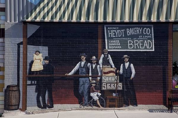
Hayes Shoe store is also the site of the Prosperity Corner Mural shown below.
People's Bank and Route 66 Underpass
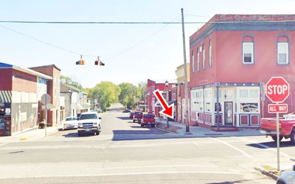
Across Smith Street is the former Peoples Bank site from 1906 when it opened to 1959 when it moved to its current location. The building is unchanged, the bank occupied the first floor. Here the WPA built during the Great Depression, in 1934, the "Smith Street Pedestrian Underpass at Route 66", it helped the children that went to the public school annex at N. Smith St. cross the Mother Road safely.
The underpass was closed and blocked, you'd never know there was one! (there are other pedestrian underpasses on Route 66 in Chelsea OK, Madison IL, Sayre OK, and Odell IL.
Below is a "Then and Now" sequence, the red arrow marks the underpass (with its concrete wall), the two story red-brick building next to the arrow, on the right, is the old People's Bank.

Mural #11: Workshop scene
Cross Route 66 and head half a block north, to 180 N Smith St. The mural here gives a view of what things were like in 1948 at the Roberts Judson Lumber Co, that produced wood and sheet metal articles. Pictured below.
Return to Route 66 turn right and to your right is another mural (Truman's).
Mural #12: Truman
At 609 W Washington Ave. The mural pictured above portrays Harry Truman (then a Senator) campaigning in Cuba at the Homecoming Fair during the 1940 primary election. Truman was later President of the U.S. after FDR died in office in 1945, and won his full term in 1949.
Cemetery and Last Mural in Cuba
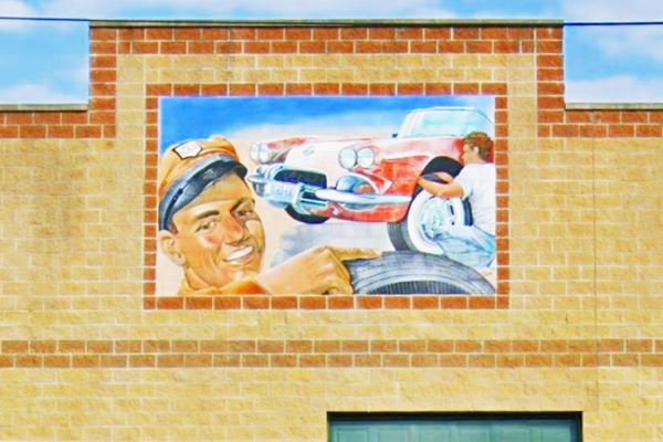
Ahead, on the western tip of town, to your left is the old "Kinder Cemetery" that dates back to 1832. This district is still known as Amanda (the town's original name). Across the street is the "last" of the murals (that line Route 66 in Cuba), the smiling tire shop attendant pictured below.
This is also the ending point of your Road trip through Cuba, drive west to continue your journey in Fanning.
Belmont Vineyard & Winery
5870 Old Route 66, Leasburg (belmontvineyards.com) for those keen on tasting wines.

Some sponsored content
> > Book your Hotel in Lebanon

Credits
Banner image: Hackberry General Store, Hackberry, Arizona by Perla Eichenblat
Jack DeVere Rittenhouse, (1946). A Guide Book to Highway 66
Architectural - Historic Survey of Route 66 in Missouri and Detailed Survey, Maura Johnson. 1993


