Route 66 in Stanton
Index to this page
About Stanton Missouri
Facts, Trivia and useful information
Elevation: 872 ft (266 m). Population n⁄a (2010).
Time zone: Central (CST): UTC minus 6 hours. Summer (DST) CDT (UTC-5).
Stanton is an unincorporated community on Route 66 in Franklin County, in the central Missouri Ozarks foothills.
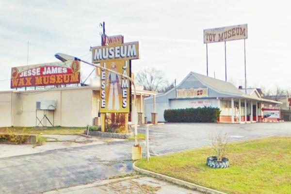
Jesse James Wax Museum on Route 66 in Stanton Missouri
History of Stanton
Visit our Sullivan history entry, for the details of the region's history, and below, for Meramec Caverns we detail the discovery, mining and use those caves had from 1720 onwards.
The post office opened in 1857 and was named Stanton. It was a small farming community in the forested hills, located on the main road from Springfield to St. Louis, known as the "Wire Road", which ran next to the military telegraph. Later this road would become Missouri State Highway 14, and in 1926 Route 66 was aligned along it. The town served the tourists who drove down US 66 and also those who visited the Caverns. Even today 150,000 visitors come to the Caverns each year. But in the early 1950s Route 66 was moved out of the town and it became a four-lane highway which was upgraded later with full Interstate freeway features, including an overpass at Stanton.
The Name: Stanton
Named after Peter Stanton who owned a mine and the gun powder mill in the area in the 1850s. The surname Stanton has an Anglosaxon origin: "Stan" = "stone" and "Ton" = "village" or "enclosure".

Where to Lodge in Stanton, Missouri
There are no motels in Stanton, but the neighboring towns have accommodation:
> > Book your hotel in neighboring Saint Clair or Sullivan
More Lodging along Route 66
There are several hotels in the area close to this town. Alternatively you can also find your accommodation along Route 66 in the neighboring towns and cities in Missouri. We list them below (from east to west):
On Route 66's Main alignment in MO
Eastwards
Westwards
- Hotels in Kansas
- Baxter Springs KS
- Galena KS
- Riverton KS
- Hotels in Oklahoma
- Miami OK
>> Check out the RV campgrounds here in Stanton
Weather in Stanton

Location of Stanton on U.S. Hwy. 66
Stanton has well marked seasons, which are the combination of humid continental and humid subtropical climates.
The winter (Jan), the average high is around 39°F (4°C) and the aveage low is a freezing 20°F (-7°C). The summer (Jul) average high is 89°F (32°C) with an average low of 68°F (20°C). Rainfall averages 44.5 in. (1.130 mm) yearly which ranges from 2.21 in (56 mm) in Jan. to 4.81 in (122.2 mm) in May. Snowfall is around 18.9 in. (48 cm), which falls from Dec. to Mar.
Tornado risk
Stanton is located in Missouri's "Tornado Alley" and Franklin County is struck by some 7 tornados every year.
Tornado Risk: read more about Tornado Risk along Route66.
Map of Route 66 in Stanton

Route 66 in Stanton, 1946 USGS Map
Heading west after St. Clair the original highway is mostly buried by the freeway. It resurfaces in some points where the old road curves away from I-44. The north Service Road that now carries Route 66 towards Stanton follows the original US66 alignment quite accurately (map).
However as you approach it deviates from the old US 66 that ran close to the railroad, on the other side of the freeway. Most of it is buried beneath the eastbound lanes on the eatern side of Stanton.
The first section just north of Stanton can still be drive is shown in this (map), the rest is gone (map with a pink line).
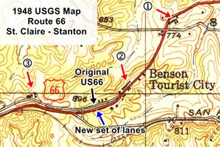
The image with a USGS map from 1946 shows the original alignment (red line) and the new set of lanes built in the mid 1940s (black arrow). Further east, the 1948 USGS map also shows the old lanes (black arrow) and the new ones (blue arrow).
There were more changes when the 4-lane Route 66 was upgraded to interstate standards and the new overpass at stanton erased many buildings at the junction of Route 66 and Hwy W. But Route 66 west of Stanton is the original 1926-50s alignment (map).
The Route 66 alignment in Stanton
Visit our pages with old maps and plenty of information about US 66's alignments.
- Rolla to Springfield (next)
- Gray Summit to Rolla (in Stanton)
- Route 66 in St. Louis (previous)
Route 66 Sights in Stanton
Landmarks and Places to See
- In Stanton: read below
- Tour to visit Meramec Caverns
Stanton and its Route 66 attractions
Historic context, the classic Route 66 in Stanton
"Missouri, a guide to the "Show Me" state" a guide published by the WPA in 1941 mentions the town which had 200 residents, adding that it was named after Peter Stanton, who ran a powder mill in the area back in the 1850s. It goes on to describe the Meramec Cavern, which was accessible from Stanton on a "graveled road (slippery when wet)" and reported that the cavern was "open day and night" with an admission fee of 40¢; there was parking space for 300 cars.
Jack DeVere Rittenhouse in his 1946 book "A Guide Book to Highway 66" said that its population was 115 and described its facilities:
Stanton garage; AAA garage; gas; cafe; store; few cabins. A good cafe here is Wurzburger's (Left)...
A few miles from here on a well-marked road, to MERAMEC CAVERN (admission charged)... a remarkable cave, one of the most popular in Missouri and worth visiting Rittenhouse (1946)
Rittenhouse mentioned the other nearby points of interest for those driving along Route 66, coming from St. Clair: "gas station & cafe 5 miles east of Stanton (Leroney's Chicken Inn), followed 3 miles east of Stanton by a "gas station, with a cafe with a few tourist cabins" and 1 mile further east was "Benson’s Tourist City, an elaborate establishment with cabins,
cafe, gas and trailer camp."
Regarding the scenery, he tells us that "US 66 winds through rich farm country. The low hills are the beginnings of
the Ozarks..."
Wurzburger's café was razed when the modern interstate was built, replacing the old four-lane US 66, to make space for the access ramps in Stanton.
Your Route 66 Road Trip across Stanton
Leroney's - The Alamo Cafe (Gone)

The Alamo (formerly Leroney's), Stanton MO. Credits
Begin this leg of your road trip east of Stanton, coming from St. Claire along the North Service Road, at the site of a Route 66 stop mentioned by Rittenhouse in 1946 as being 5 miles east of Stanton: "Gas station and cafe here." Edward Lincoln Leroney (1906-87) built his "Leroney's Chicken Inn" on a property that had belonged to his wife's family (her name was Susan Francis, nee Brackett). It included a Texaco service station, cabins and even a dance hall.
It was located near St. Louis Inn Road and Route 66, on the NE side of the intersection. We marked it with a (1) in the map (click on the thumbnail map to see full size map) published in 1948 by the USGS.
Ed Leroney sold it in 1945 moving to St. Clair where he bought the Commercial Hotel. The old Leroney's became The Alamo, it burned down in 1952.
The original buildings are gone (burned) all that remains is the paved parking area in front of a private home. See its Street view and an 1964 aerial photograph with the buildings on the inside of the curve, to the right of Route 66.
Ozark Court Motel

The Ozark Court motel neon sign. Stanton MO. Credits
Head west, and after one mile, on the N Service Road West is the site of the former Ozark Cafe, part of the Ozark Court Motel.
It is marked with (2) in the thumbnail map further up. Although the map says this is "Benson Tourist City", this is not correct. Benson's was located further west, at (3); more on Benson's further down.
The roadside court belonged to a Mr. Duke and dated back to the 1930s. It became a laundromat in the 1960s.
Ozark Court Neon Sign
It was famous for its prancing deer neon sign made in 1952 and rescued by a collector of Route 66 artifacts in 2002. Its current owner, Greg Rhomberg, acquired it in 2021 to restore it.
See the "Then and Now" sequence of the old motel below. The red arrow mark the neon sign (right) and the surviving motel building (left), notice the same block wall by the now ruined office.
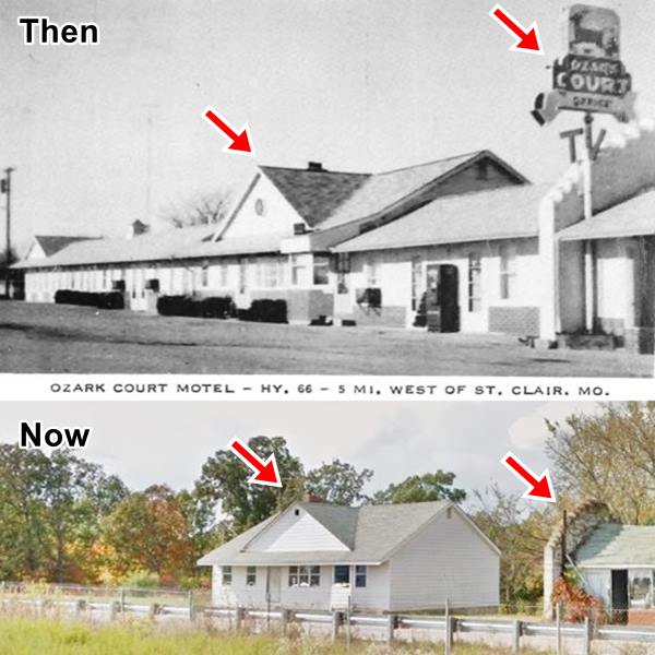
Now the old court's office is crumbling and falling apart. (street view when it was still standing) as you can see in the image below.
The red arrow marks where the now gone neon sign was located.
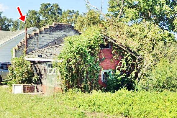
The Ozark cafe was part of the complex (pictured below), it stood on the eastern side close to the office.
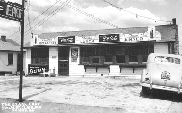
It was followed by "Oak Ridge cabins", now gone (0.3 mi. west), and after the four-lane alignment was built, on the sout side of the freeway, by the "Trade Winds motel".
Trade Winds Motel
Located where the West Springfield Rd. coming from St. Clair via Anaconda - Morrelton met Route 66. Now it is cut off from the interstate, and faces the S. Service Rd. The gable roof building with a linear lay-out was partly burned down. However, its sign is still standing. The complex was built in the late 1960s, and first appears in a 1967 USGS map. Jesse and Louise Renshaw were operating the Trade Winds Motel, six miles west of St. Clair, when this view was made. The place had a nice swimming pool, featured TV and air conditioning, and was "open year round". The complex has burned down in the early 1990s, and was razed in around 2015 (Current view), an empty plot of land.
Head west along the north Service Road to see the remains of "Benson's Tourist City", mentioned by Rittenhouse, and marked with a (3) in the map further up.
Benson's Touristy City
To your right on the North Service Rd. West, at 2675 Route 66, on a wide curve. This aerialphoto from 1945 shows the buildings on the north side (top) of Route 66.
Their postcard below tells us it had "16 All Approved AAA Modern Cabins 24 Hr. Cafe - 7 Miles West of St. Clair, Mo. U.S. Hiway 66" on the back it reads: "Our motto Clean - Respectable Your Home away from Home" and it owned by Mr. and Mrs. Lewis J. Benson. Now only a few buildings remain.
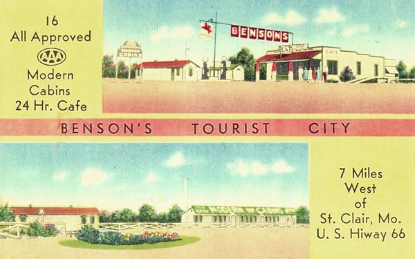
The site had a Mobil gas station still standing but greatly modified, a long building with cabins (bottom right side of the postcard) that was torn down but its foundations can still be seen in this satellite view.
Benson's nowadays, cabins on the right, old station middle.
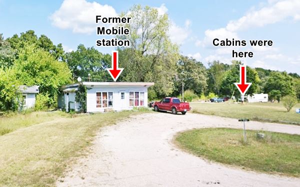
McGinnis Sho-Me Courts
The Bensons complex was also known as "Del-Crest". The Bensons later sold it to a couple, the McGinnis, who renamed it "McGinnis Sho-Me Courts"; it offered comfortable sleeping in "Modern Cabins" and "famous Ozark food". Below is a vintage 1950s view of the Sho-Me Courts, notice that the gas station has its current appearance, and the cabins on the far right:
Benson's nowadays, cabins on the right, old station middle.
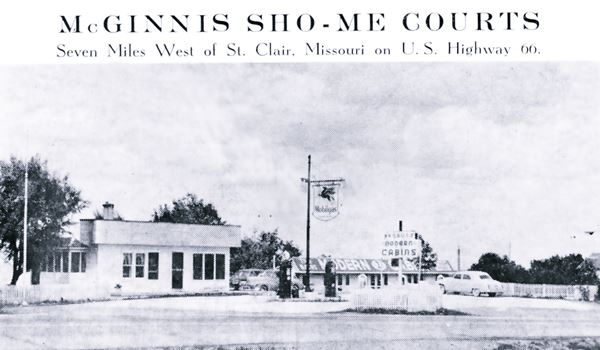
Just ahead, on the west side of Whispering Pines Drive (NW corner with Route 66) was another Motel, the "Silver Star Court".
Silver Star Court site
This complex had indivitual cabins that later were linked by garages built between them. Later these too became rooms. It also had a restaruant. It was first owned by George Wilson and was called "Midway Café and Motel". Then, it was operated by Cora and Paul Smith from 1957 to 1972.
The motel closed when I-44 was built over the old four-lane Route 66, and the new limited-access freeway cut them off. See it in this 1964 aerial photograph and its empty plot in this 2021 Street view. It was torn down and nothing remains.
The old route 66 is buried after this point by the freeway (the N Service Road is a modern addition), and it resurfaces at the site of another classic cafe and motel:
Kovac's Cafe - Motel Meramec
See this Map with location. on the NE corner of Route 66 and Llolar Branch Rd.
This place began as the Motel Meramec, with Cabins and home cooked "Chicken Dinners".
The arrows mark the two cross gables facing Whispering Pines Dr.
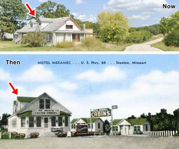
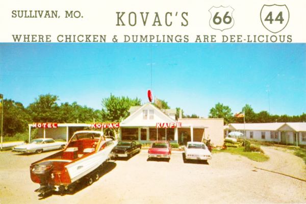
Later it became "Kovac's Motel Cafe", and the two cabins on the eastern side of the property (see postcard above, on the right side), were joined into a single building (see photo below), this building has gone.
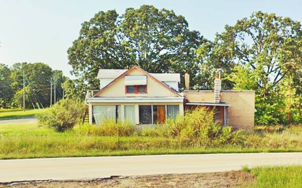
Kovacs was "Where chicken & dumplings are dee-licious" and oddly, it advertised as being located in Sullivan, not stanton. The building is still standing and is
now a private home.
As you can see below it hasn't changed that much: the postcard with early 1960s cars and a wooden boat with an outboard motor gives us an idea of what it looked like in the old Route 66 golden days.
The original roadway continues west, overlaid by the freeway. North Service Rd. acts as the "old 66", though it wasn't. The next motels linked with the old four-lane divided highway that allowed access to frontage properties, unlike modern freeways that have limited access.
El Rancho Motel
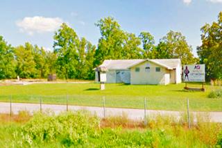
Passing Lawrence Lane, to your right, on the SW corner is the former El Rancho Motel, see this map showing where it is. Now it has become "Animal Adventures Park".
It was a "Brick ranch style court" according to th e AAA Directory. It was built ca. 1950 and had eight units with the brick walls mentioned in its advertising.
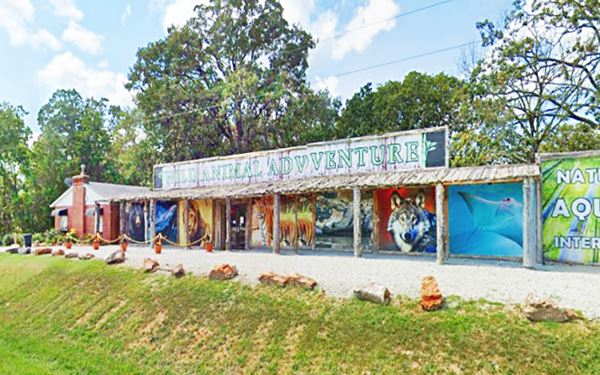
Below is a vintage image, an aerial photo taken in 1986; you can see the linear layout, the gabled roof and the office and garage buildings on its western tip (left).
Shady Rest Center
Pictured above, it is 0.2 miles past El Rancho, on N. Service Rd. West, to your right, was the former "Shady Rest Center", a motel and cabin complex built between 1938 and 1941. It was also known as "Blue Top Cabins". There were 15 cabins, later it became a residential care center. The cabins are now all gone. The motel was an "L-shaped" building on the western side of the property, that is still standing. See its current view. Notice the original concrete curbs.
Keep on straight and go past Exit 230 to visit the site of the now gone "Stanton Motel."
Stanton Motel
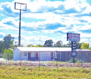
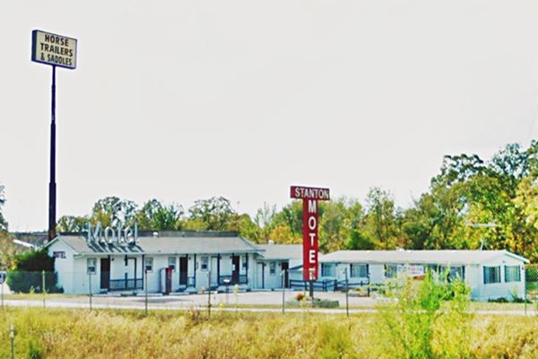
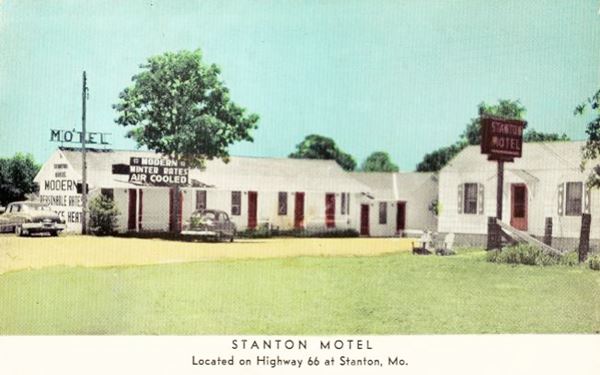
N Service Rd. West, Stanton, just 0.1 mi east of Exit 230. Stanton Motel was still operating until recently, but now is a storage unit. Its main feature were its red "T" shaped sign.
Built around 1950 it catered to the newly realigned Route 66 with its four lanes.
It has seven units under a gabled roof, in an "L-shaped" layout. It had "modern air cooled and central heated" cabins at "winter rates - reasonable rates". It promoted itself as bieng the
one closest to the famous Meramec Caverns. Below are a set of "then and now" photos and postcard so you can see how it evolved through time:
Downtown Stanton

1960s view Stanton, Credits
Click image to enlarge
Turn around head back to the overpass at Exit 230, turn right into Hwy W and cross the freeway into Stanton. Ahead Hwy W crosses the 1926-50s Route 66 alignment.
The small image shows this intersection in the 1960s (click on it to enlarge), at that time Route 66 was a four-lane highway, and level with the town (I-44 goes through a cutting here nowadays). See this same spot nowadays.
To your left the original Route 66's 1926 alignment runs for a short distance and halts at a dead end (map), the rest is gone (map with a pink line). On the NE side of the intersection was Wurzburger's (3) café mentioned by Rittenhouse, owned by Effie and Louis Wurzburger; a service station was built on the site.
If you continue straight, crossing the railroad, you can visit the main attraction in town: Meramec Caverns, described further down.
Here at the crossroads there were several landmarks that were razed when I-44 was built: on the SE corner (1) was the post office in Armistead's store, facing Hwy W, and a Shell gas station facing Route 66. Across the road, on the NW corner was Hammer's General Store (2), a two-story red-brick building that later became Crawford's Market. It was torn down to build the freeway's access ramps.
Turn right, towards Sullivan along Route 66. Just past the Exit is the former "Jesse James Wax Museum" and the site of the "Windmill"
The Windmill Lounge, Restaurant and Travel Cente (gone)
Torn down around 1987, it stood behind the "Museum" next to a gas station to your left, on the old Route 66. It had an eye-catching windmill next to its entrance. The card below is misleading as it says it is "located near the entrance to Jesse James hideout at Meramec Caverns", it offered "the finesd foods... spacious dining Rooms... Antique shop... the Windmill Missouri's largest information and Travel Center."
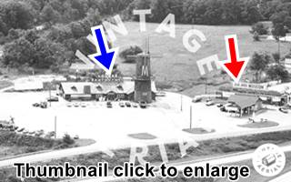
This is the street view nowadays. In the thumbnail (click on it to enlarge) you can see the restaurant (blue arrow) and the gas station (red arrow) still standing, next to the Museum.

1986 aerial photo Shady Rest
Credits
Gas Station
The red-brick gas station has a gable roof canopy over the now empty pump islands, and a simple gable roof square plan office. No garage or service bays.
Jesse James Wax Museum
Route 66 Roadside attraction
To the right of the old gas station, on the left side of the highway. It closes in winter.
The theme of the museum is that the infamous bandit Jesse James didn't die in 1882 during a shootout. Instead he lived to the age of 102, dying in 1951
under another name. With wax figures and plenty of memorabilia it is Pictured above at the top of the page.
More info at the Museum's website.
Toy Museum - Closed
The Antique Toy Museum next to Jesse James' wax museum is permanently closed. It exhibited the collection of Bruce Barnes from 1988 to 2008.
Delta Motel
The former motel is located next to the Toy Museum, to your left. It had 11 rooms and was built with concrete blocks and a flat roof. It closed and became apartments.
It was Built around 1950 and has a streamline moderne rounded 2-story north wing. The restaurant was on the second floor, with the office beneath it.
There were more units behind the main building and a swimming pool facing Route 66.
Cavern City Hideout Motel and Restaurant
Continue west towards Sullivan and just 0.2 mi. ahead, to your right, between Route 66 and the freeway is another Classic Motel.
Now a private property, it has changed a lot since Lester Dill (owner of the famous Caverns) opened it as Cavern City Courts in 1939.
At that time it faced what is now the North Service Road East (Route 66 in its 1926 alignment). It had four cabins and a campground. The gas station and garage (now gone)
were added in 1949.
It also served as the "Ozark Tourist Bureau" as shown in the sign in the postcard below.
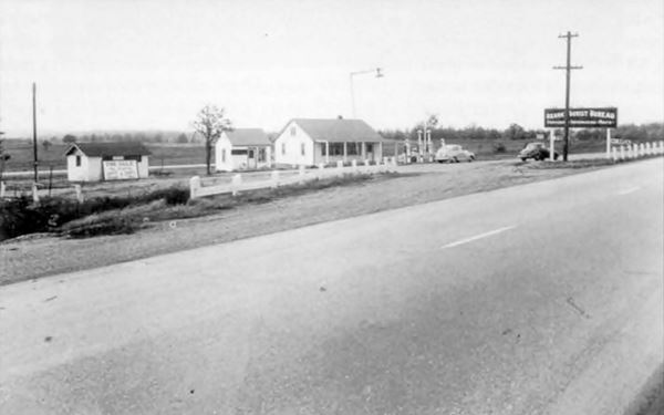
As you can see, the crossgable building below, incorporated the old gas station!

In 1956 it was sold to the Leland and Elizabet Wall and by then, Route 66 had been realigned on the western side of old highway so the property moved its entrance to face it (the 1950s Route 66 is now under I-44's roadbed and had access to the site). They added another unit with 6-rooms that can still be seen if you look to your right from the eastbound lanes of I-44 as shown in this Street View of motel units. The modern limited-access I-44 that replaced the old 4-lane Route 66 cut the motel off.
Randleman's Station and Restaurant

1930s postcard Randleman's. Stanton
Credits
To your left, on the curve, 0.1 miles west of Cavern City Hideout Motel and Restaurant, there was another Restaurant, Garage, and D-X servie station ran by William Egar Randleman and Olive Armstead Randleman. Now it is a private property. Nothing remains of the original buildings, only some paving on the shoulder where the access was. See it in this 1945 aerial photo (on the right side of the higway), and in this street view.
This marks the end of this leg of your Route 66 Road Trip through Stanton. There is one more sight a short distance east of the town, we describe it below.
Tours: Meramec Caverns
Short Tour to Meramec Caverns
Classic Route 66 attraction
Just 4 mi. east of Route 66. Map with directions.
"Missouri's Buried Treasure", the largest cave West of the Mississippi, was discovered in 1720 by French explorer Philipp Renault, he found the cave had saltpeter (so he named it Saltpeter Cave). This compound is potassium nitrate used in those days to make gunpowder. It was mined for the mineral until the Civil War.
Though used as a dance venue in the 1890s, it was not until Lester Dill (1898 - 1980) bought it in 1933 that it became a tourist attraction. Dill already ran Fisher's Cave in Meramec State Park, so Dill renamed it as the "Meramec Caverns".

Jesse James Hideout in Meramec Caverns. Credits

Rock chamber with stalactites and stalagmites. Meramec Caverns. Credits
Meramec Cavern Promotion: Barns and bumper stickers
Dill promoted his tourist attracton in very cunning ways: He paid farmers so that they painted the
words "Meramec Caverns" on barn roofs all across the region, 14 states in all!
See some surviving barns on Route 66 (with images) in our website:
He also used bumper signs (tied to the bumpers), paying kids to affix them to the cars of his visitors (the first self-sticking ones were invented by Forest Gill in the 1940s).
He gave the caverns catchy names: "Jesse James Hideout", "Moonshiners Cave", "The Stage Curtain", "Wine Room" and more. He was dubbed "America's Number One Cave Man" and the caverns attract over 150,000 visitors each year. More information at their website.
Jesse James, the Bandit
Historical Marker
At the cavern there is a marker informing that outlaw Jesse James (1847-1882) and his men hid there in the early 1870s with his gang. He is said to have used it also during the Civil War, when he rode with Quantrill's Guerrillas.
Head back to Santon to continue your Road Trip westwards into Sullivan.

Some sponsored content
> > Book your Hotel in Lebanon

Credits
Banner image: Hackberry General Store, Hackberry, Arizona by Perla Eichenblat
Jack DeVere Rittenhouse, (1946). A Guide Book to Highway 66


