Two Guns. Route 66
Index to this page
About Two Guns, Arizona
Facts, Trivia and useful information
Elevation 5,415 ft (1.652 m). Population zero (2025). Time zone: Mountain (MST): UTC minus 7 hours. Summer (DST) no DST⁄ PDT (UTC-7).
Two Guns is a ghost town that straddles US Route 66 in Coconino County, in the central part of Arizona.
For the early history of Two Guns, please see the History of Winslow, located very close to the now abandoned town.
Spanish explorer Antonio de Espejo (1540-1585) led an expedition into New Mexico and Arizona in 1582–83, after crossing the Little Colorado River he came across the Canyon Diablo which he managed to cross on his way to the Verde Valley in central Arizona. He was the first European to do so.
After Arizona became a part of the US following the Mexican American War of 1846-48, Captain Lorenzo Sitgreaves explored the area in 1851 along the Little Colorado River, passing by the Canyon Diablo. In 1853 Lt A. W. Whipple surveyed the area for a future railroad to California and he came across the Canyon Diablo, which he named, but only managed to cross north of Two Guns.
The name: Canyon Diablo
The Canyon was named by A. W. Whipple on Dec. 14, 1853 who wrote: "we were all surprised to find at our feet, in magnesian limestone, a chasm probably one hundred feet in depth, the sides precipitous, and about three hundred feet across at top. A thread-like rill of water could be seen below, but descent was impossible. There was not the slightest indication of a stream till we stood upon the brink and looked down into the canyon... The canyon which interrupted our march to-day has been named Canon Diablo".
The word "Diablo" is Spanish for "Devil", so it is "Devil's Canyon".
In 1857 Lt. Beale used this northern route to reach California, and it was named the Beale Road or the California-Santa Fe Trail.
Trivia: Last Battle
The last important battle between Indians and the U.S. Army took place at Big Dry Wash on July 17,1882, just south of Two Guns. The Apache Chief Natiotish was defeated.
A shorter route was desireable so the area between Winslow with Flagstaff was surveyed in the early 1880s, and the Atlantic and Pacific Railroad, which later became part of the Atchison Topeka and Santa Fe Railroad (AT&SF) used it to build a railroad through this barren region. The tracks are located to the north of what would later become "Two Guns" and the Canyon Diablo depot was built there. Now it is a ghost town. Further north lay the land of the Hopi and Navajo Reservations.
The first highway in the area, in the early 1900s, the "National Old Trails" highway opted for an alignment south of the tracks, shortening the distance between Winslow and Flagstaff. This led to the establishment of Two Guns. Later Route 66 was aligned using the National Old Trails road. Read more below (Recent History).
The name: Two Guns
William Surrey Hart (1864 - 1846). Was a world famous silent movie star, who took part of about 70 films shot between 1914 and 1925.
His "Two Gun Bill" look was known around the world. He retired in 1925 to his ranch and became a philanthropist.
Harry E. (Indian) Miller, who opened the first trading post here said that he worked in silent movies and knew Hart, and that he adopted the town's name as a homage to the actor.
Accommodation: Where to Stay in Two Guns
Find your room in the motels nearby in Winslow or Flagstaff:
>> Book your room nearby in Flagstaff or Winslow
More Lodging Near Two Guns along Route 66
There are plenty of lodging options in the cities and towns along Route 66 east and west of Two Guns; click on the links below to find your accommodation in these towns, listed from east to west:
Eastwards
In Arizona Along Route 66
Westwards
You are so close to Las Vegas and the Grand Canyon!
There is a RV campground close to Two Guns in Barringer Crater
The Weather in Two Guns

Location of Two Guns AZ on Route 66
The climate of Two Guns is dry, temperate and arid. Relative air humidity is low and this leads to wide variations beween night and day temperatures all through the year, causing hot dry summer days but cool summer nights and cold winter ones.
During summer (Jul), the average high temperature is around 94.5°F (34.7°C) and the average low is 61.9 °F (16.6°C). In winter the average high (Jan) is 49.5°F (9.7°C) and the average low is about 20.8°F (-6.2°C), well below freezing pont.
As expected for an arid area, rainfall is scarce: 6.99 inches (178 mm) yearly and about half of it falls from July to September (3.1 in. - 79 mm). Snowfall is also light, with only 6.4 inches (16.3 cm) per year, between Oct. and April.
It is sunny in Two Guns, only 53 days per year are days with precipitation.
Tornado risk
There is almost zero tornado risk in Two Guns: Coconino County has no Tornado watches. The area west of the Rocky Mountains has virtually no tornado events at all.
Tornado Risk: read more about Tornado Risk along Route66.
Map of Route 66 in Two Guns, AZ
Read the Detailed Description of this segment (Winslow to Winona). Below is the interactive map:
>> Custom map of Route 66 in Two Guns

Thumbnail of the 1910s N.O.T. map showing Canyon Diablo. Source
Click on thumbnail map to enlarge
The map (Click on the thumbnail map to enlarge it) shows Canyon Diablo and Two Guns. The original Autotrail that linked Winslow with Flagstaff didn't follow the railroad, instead it ran straight west to the meteor crater at Barringer, and then north to where Two Guns is, where it crossed the Canyon Diablo, then it headed west to Winona and Flagstaff along a course more or less located where US 66 and later I-40 would run.
In 1926, Route 66 was aligned down the N.O.T and a growing flow of motorists drove down the new unpaved highway. Later it was moved north from Winslow to Two Guns, along its present course.
Route 66 Alignments over the years
There were several alignments at Two Guns; you can see them in our custom map with the missing segments of Route 66 in eastern Arizona. This map's color coding is the following:
- Black line marks the extant section from Barringer Crater access road to Two Guns. This carried US66 from 1926 until the 1940s, when it was moved to an alignment now overlaid by the freeway.
- Gray line west of Two Guns is a dirt section (crosses the canyon along the historic 1915 Route 66 Canyon Diablo Bridge) and meets the later alignment further west. It carried the N.O.T. and Route 66 until it was realigned in the 1930s.
- Blue line is the 1930s to 1938 alignment out of Two Guns. It was replaced by a new roadbed that ran where I-40 is now located
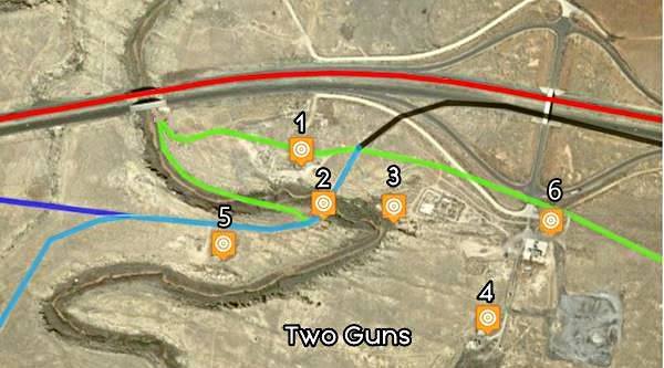
A Map showing Two Guns and its landmarks
References
(1)Two Guns 2ndZoo and 1940s Texaco ruins, (2) Two Guns Trading Post Ruins next to Historic Bridge, (3) Apache Death Cave, (4) Old KOA Campground,
(5) First Texaco and Zoo, and (6) 1970s Shell.
The colors mark the Route 66 alignments: in green the N.O.T. highway, in black the 1926 to 1940s US 66, light blue is the N.O.T. to in the 1930s US 66, blue shows the 1930s to 1938 alignment and the red line is the 1940s to 1979 US 66.
Landmarks and US66 in Two Guns, AZ. Click on map to enlarge
Route 66 Alignment near Two Guns
With maps and full information of the old roadway.
- Winona to Williams (next)
- Winslow to Winona (Two Guns')
- Lupton to Winslow (previous)
Ghost town of Two Guns, Arizona, its Sights and Attractions
A ghost town on the Canyon Diablo
Historic context, the classic Route 66
In 1946 Jack DeVere Rittenhouse published his "A Guide Book to Highway 66" and gave a very interesting description of US 66 in those days; many attractions and landmarks are mentioned and give us a very rough idea on how it was to drive along Route 66 in the 1940s. When he mentioned Two Guns, he pointed out the following:
One establishment, offering gas, lunchroom, and curios. At the rear of the building is a small zoo exhibiting western animals Rittenhouse (1946)
He added that the former alignment of Route 66 "ran behind this building", referring to the 1926 - 1938 alignment of Route 66. He also mentioned the "Old Apache Caves" that could be visited near the service station.
Just west of Two Guns, the highway crosses Canyon Diablo, which Rittenhouse described as "Amazing canyon which appears suddenly as a great gash in the level plain... over 100 feet deep and several hundred feet wide."
Sights in Two Guns
If you reach Two Guns via the freeway, head south from I-40s Exit 230, take the overpass along 2 guns Rd. to its junction with Old Route 66 at the interchange. You can also reach Two Guns from Meteor Crater along the Old Route 66 alignment that runs south of I-40).
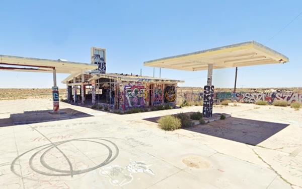
Graffiti covered Shell Service Station
Straight ahead, passing the cattle grate, the dirt surfaced Two Guns Rd. heads south. To your left is a deserted service station (the third and last one built in Two Guns).
It is a former Shell station with the style adopted from 1950 to around 1970. It has a Ranch Style appearance: a low sloping gabled roof with two parts, and broad eaves along the front. The office on the right has a secondary gable. Brick walls and a column or chimney-like extension rising from the roof where the Shell logo was displayed. The large transoms provide natural light in the service bays. This station had three pump islands, all of them emtpy. It is covered with graffiti.
Shell with graffiti
Abandoned KOA Campground
The dirt road passes by the ruins of a stone wall with the KOA Campground sign (also covered with graffiti) and heads south for couple of hundred yards where it reaches the remains of a campground.
Below is a "Then and Now" series of pictures of the abandoned campground:
1970s postcard KOA Campground
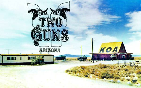
Two Guns in 2013, the abandoned KOA campground before the main building was razed
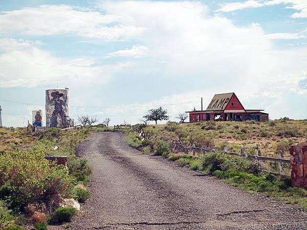
The same spot in 2022: steep gable roof building has been torn down:
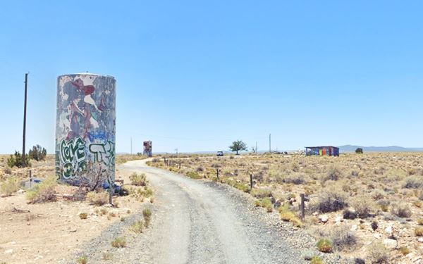
The steep gabled building with the word "Kamp" painted on the roof has been torn down, a pile of rubble marks the spot. The two tanks are still standing, one with a cowboy painted on it, and a grafitti decorated swimming pool next to the rubble. All of these buildings are in ruins. Time is unforgiving. Turn back to the Shell Service station to visit Two Guns proper.
Recent History of Two Guns
To put the landmarks in context, first let's learn more about the history of Two Guns:
The Railroad crossed the Diablo Canyon at a point where a bridge could be built easily, but the first road that linked Winslow with Flagstaff adopted a more southern course shortening the original wagon road that went through Mormon Crossing. The 1907 highway was built between Flagstaff and Winslow and it crossed the Canyon at Two Guns. It did not have a bridge, instead it zig-zagged down the embankment on one side, crossed the dry river bed and climbed up on the south side of the Canyon. In the Map shown further up, the green line shows the National Old Trails (N.O.T.) Highway in its pre-1915 alignment.
The first settlers were the Oldfields who built their post 3 miles south of Two Guns along the N.O.T. Highway. They were followed by Ed Randolph, who set up his store next to Apache Cave. In 1915 the bridge was built across the Canyon, and in 1922, World War I veteran Earl Marion Cundiff purchased Randolph's claim and built his store on a homestead of 320 acres.
"Indian" Miller
Cundiff leased the property for 10 years to a man named Harry E. "Indian" Miller in 1925. Miller claimed to have lived among the Philippine headhunters while he was in the Army during the Spanish American War (1898). He called himself "Chief Crazy Thunder" and said he was part Apache and part Mohawk.
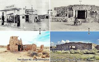
Miller moved there with his wife and built his trading post west of the bridge, it had a cylindrical shaped turret and also a Texaco filling station. He placed a Hopi House next to the bridge and added fake stone ruins and and posted a sign stating that they were part of the "Apache Caves". He also built his "Zoo" along the Canyon behind his gas station - store (and home) it held local wild animals like mountain lions (pumas).
Miller realized that the caves had potentiaal so he built some fake Pueblo ruins by the first cavern's entry and linked it to the store with a path and wooden bridge. The tourists paid to visit the Hopi ruins and the caves.
Miller called his complex "Fort Two Guns", but when Cundiff applied for a post office, the name was not acceptable, so "Canyon Lodge" was used instead; the post office opened in 1925.
But Cundiff and Miller did not get along well, and on March 3, 1926 Miller shot an unarmed Cundiff and killed him; he claimed it was in self-defense and was acquitted.
The store's interior burned in 1929, and that same year Earl's widow, Louise Cundiff built her own tourist store on the eastern side of the bridge. Miller left the state to avoid further prosecution and just beyond the Arizona state line in Manuelito New Mexico he repeated his show; building a zoo on US 66 with fake ruins and a phony cave, the Cave of the Seven Devils. He remained there until his death in 1952.
Louise Cundiff married Phillip Hesch in 1934 and they built their Two Guns Texaco service station in 1938 along the brand new alignment that had just been completed that year (now overlaid by the freeway) Behind it they relocated the New Zoo.
The zoo had already closed by the time S. I. Richardson bought the place in 1950. He leased it to several operators and finally sold it to Benjamin Dreher, who replaced the old service station in 1963 by a modern one with a cafe that burned down in 1971.
In the late 1960s, the place revived: a motel, restaurant, coffee shop, gift shop, garage and service station were now on site. The zoo was rebuilt and a reptile exhibit added. Some of the old stone buildings were restored. But the fire ended it all.
Later, a Shell sevice station was built and KOA campground opened. Both went out of business and are now abandoned.
Touring Two Guns
At the abandoned Shell station take a left, along Old Route 66 as it curves around I-40s exit and at the point where the paving ends, to your left, is what is left of the 1940s Two Guns Texaco, and (second Zoo) that burned down in 1971.
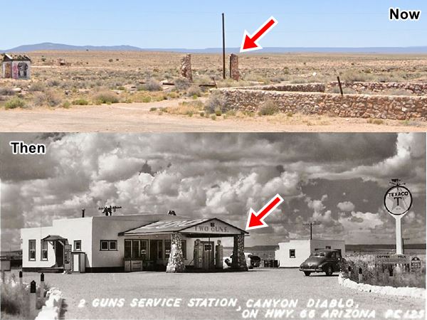
1940s Two Guns Texaco Service Station
Here once stood a Texaco gas station (all that remains are the two stone columns that held up the service station's gabled canopy. Below is a photograph of the station in the 1940s and nowadays. Only the stone pillars are standing. This was the second Texaco at Two Guns, the other Texaco was build further west, on the other side of the Canyon.
Red arrows mark the surviving stone pillars
1970s Coffee Shop and Store
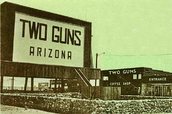
In the 1960s Benjamin Dreher, built a coffee shop and store that incorporated the old Texaco (you can see the stone columns in the image below under the "ENTRANCE" sign), the place burned down in 1971 sealing its fate. The stone wall enclosing the large "TWO GUNS" sign is still there (St. view):
The stone pillars are under the Entrance sign:
Second Zoo
Behind the ruins of the Texaco you can see the remains of the "second Zoo" with the words "Mountain Lions" clearly visible on the stone wall -see the picture above. Behind it is the Canyon.
The remains of the Zoo at Two Guns, Route 66, 2022
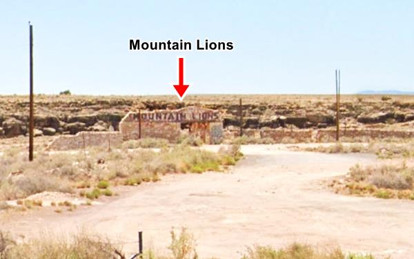
When visiting private property, don't touch or remove anything, seek owner's permission before trespassing.
This is the second Zoo because the first one, located to the west was cut off from visitors when Route 66 was realigned in 1939.
The Apache Death Caves
The caves are 1,000 ft. to the south east of the Zoo. In the 1960s, the site's brochure promoted their hourly tours as follows:
Apache Death Cave
- Scene of the merciless massacre of mighty Apache Warriors!
- Explore this mysterious underground world.
- Relive the revenge the crafty Navajo found upon his hatede enemy
Two Guns brochure (1960s)
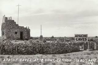
1930s picture Apache Death Caves. Source
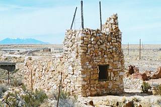
Current view, Apache Death Caves. Source
The cave is actually a series of natural caverns that extend for several miles under the sandstone.
The legend behind the caves is the following: In the late 1800s, Apache warriors would attack the Navajo people and disappear without a trace. After a bloody raid the Navajo set out after their attackers and by chance discovered them hidden in these natural caves. After learning that the Apache had killed their Navajo hostages, the furious Navajo blocked the narrow entrance to the cave with wood and branches and lit a fire. The smoke killed 42 Apaches and disuaded them from further raids in the area.
From the Zoo you can drive along the dirt road, take a left and you will reach the gravel road that leads to the Historic Bridge, this was Route 66 from the N.O.T. days until 1939.
Route 66 Canyon Diablo Bridge
Old Route 66 and Canyon Diablo, Two Guns, AZ.
Listed in the National Register of Historic Places
This bridge is well over one hundred years old, it was built in 1915, and spans the Canyon Diablo gorge at Two Guns.
It is a reinforced concrete Luten arch bridge with cantilevered roadway (Daniel Luten patented this strong yet light type of bridge). The deck has an earth fill. It is 146 feet long and has a 128 ft. span (44.5 and 39 m). It cost $ 9,000 at that time (roughly $250,000 nowadays).
The bridge is 11 years older than Route 66 because it was built on the National Old Trails highway to avoid the riverbed crossing in use until then. Later when Route 66 was aligned through the area, it adopted the course of the National Old Trails road.
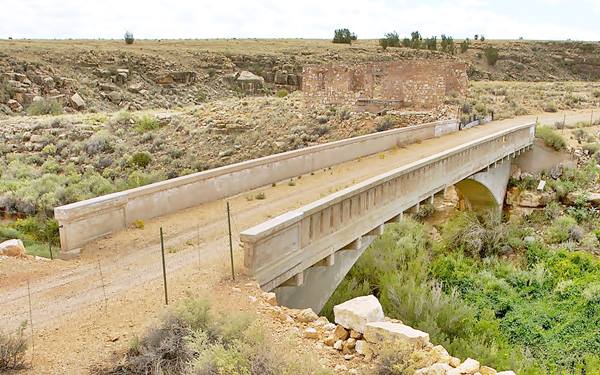
It is now on the abandoned grade of U.S. 66, which was replaced in 1938 by a new paved alignment built just to the north of Two Guns (and is now buried under I-40's roadbed).
Ruins beyond the Canyon
The original Two Guns Hopi Trading Post
After crossing the bridge, to your left, On the south side of the highway is a derelict building with a square-shaped floor plan (you can see it in the picture above, on the left side); it was the old trading post.
Head west along the dirt road, the original 1915-26 National Old Trails (and 1926-38 US 66) just 800 ft. to the west of the bridge, to your left is another set of buildings. This was the original complex built by Miller in 1925: home, store, Texaco filling station and the original Zoo.
Original 1920s Texaco
Close to the highway is a ruined rock building with a cylindrical turret on its western side, this was the Texaco Gas Station and store operated by Miller. Behind it, close to the Canyon, he built his first zoo with gila monsters, mountain lions and wild cats. We prepared a composite image combining "Then and Now" images of the buildings, click on it to enlarge (Source).
First Zoo
Built behind the store, the zoo was home to gila monsters, cougars, wild cats, Javelina Hogs and even a lynx. The building is still standing, its back to the Canyon, facing the now abandoned Route 66 alignment.
Continue your Road Trip
This leg of your Route 66 road trip in Two Guns ends here. Turn around and head back to the Freeway. You can head west into Twin Arrows or, spend some more time in the area and explore the Ghost Town of Canyon Diablo, north of Route 66.
Canyon Diablo ghost town
Elevation 5,429 ft (1.656 m). Population zero (2025).
Getting to Canyon Diablo
It is 4.2 miles NW of Two Guns; this is the Map from Two Guns to Canyon Diablo.
Head north from I-40s Exit 230, turn west (left) and then right. The rough gravel road (make sure you want to drive along this type of road) heads north on the east side of Canyon Diablo. If the weather is dry and your vehicle has high clearance and 4WD you should not have problems getting there. But if it is wet and muddy or you car is low, don't try it! Watch out for rattlesnakes -wear boots. Respect the site and don't remove anything.
Canyon Diablo
It is located inside the Navajo Reservation in Coconino County, Az., its native name is "Kin Ligaaí".
In 1881 the Atlantic & Pacific Railroad (later absorbed by the Atchison Topeka and Santa Fe Railway) reached the Canyon Diablo gorge on its way Flagstaff and began building a bridge to span the chasm.
Some financial difficulties halted construction and delayed the bridge until the end of 1882; in the meantime the construction crews had fun in a boom town that sprouted beside their camp: Canyon Diablo.
It soon had around 2,000 residents and its main street aptly named "Hell Street" had 14 saloons, 4 brothels, and 10 gambling places. The town was renown for its debauchery and violence. Trains were robbed here at Canyon Diablo station, a famous one took place in 1889, when four cowboys led by Jack Smith took off with over $140,000 in gold and currency plus $2,500 in silver dollars. Only $100 were recovered when the bandits were captured, so the rest of this treasure chest lies buried in the Canyon Diablo rim near Two Guns.
Once the bridge was completed, the workers moved out and the railway soon reached Needles California where it linked with the Southern Pacific Railroad on Aug. 9, 1883.
But this marked the demise of the town. Residents moved out and the town died. The Trading Post became a post office in 1886, but by the early 1900s it was the only building in town. When the Flagstaff to Winslow highway was built a few years later, it bypassed the town and chose an easier passage further south, through Two Guns. However the post office survived for some time, and that is why the official name for the neighboring Barringer meteor crater is "Canyon Diablo Meteorite".
Nowadays the place is compeletely abandoned, but you can still see the foundations and some rubble from the walls of the trading post. There is a also an abandoned cemetery.
Cemetery
The rowdy workers violence and the shootouts led to the creation of a cemetery which has 36 graves, only one of them belonging to a man who died a natural death: the German trading post owner Herman Wolfe.
He was born in 1805 and passed away in 1899 at his post at "Wolfe's Crossing" 12 mi. north of Leupp, on the Little Colorado River his body was taken to Canyon Diablo for burial. He traded with the Navajo, who called him "Hostiin Chaa" or "Mr. Beaver", after the beaver pelts he dried, caught in the river. His grave was improved by a German relative after World War II.
Canyon Diablo Railway Bridge
The canyon is about 256 ft. deep at the bridge (78 m) and presented an obstacle to the tracks being laid westward across Arizona by the Atchison Topeka & Santa Fe Railway.
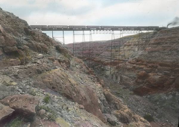
The original bridge served from 1882 to 1942, and was a trestle bridge (its foundations are still visible). Heavy World War II payloads required a stronger bridge, so the current one was built at that time.
The current bridge is a steel arch bridge with one central 300-foot hinged arch and two side spans measuring 120 ft each. The total lenght is 544 ft. (166 ft.).
It belongs to the BNSF (Burlington Northern Santa Fe Railroad, former AT&SF RR) and is private property within the Navajo Reservation. No trespassing allowed.
The Canyon itself
The Canyon is a temporary water-course that is mostly dry and only has water during the wet spell of the summer Monsoon and during spring, when snow melts in the mountains near its sources. The total land area of the Canyon Diablo basin is 767,000 acres (3.104 km2). The Canyon Diablo river is 80 miles long and has a roughly southwest to northeast course.
The canyon (and also that of nearby Canyon Padre, part of the same drainage basin) is quite narrow and very steep walled. This is caused by the erosion of the hard Kaibab limestone by swift current streams carrying sand that cuts away the limestone. Even though the canyon is mostly dry, the summer rain causes considerable transient flows of water.
To the north and west, beyond the canyon there are many ridges of volcanic rock, announcing the volcanic area that surrounds Flagstaff, the San Francisco Mountains, these provide snowmelt to feed the river.
The canyon meets the Little Colorado River 6 miles nortwest of Leupp.
It was a formidable obstacle for those trying to cross it along the wagon trails opened after the 1850s.
Outdoors and Nature
The area close to Two Guns
Heading west from Two Guns the road climbs into the Arizona Plateau, a table-land which will rise all the way to Flagstaff. The dry desert will gradually become a forested region.
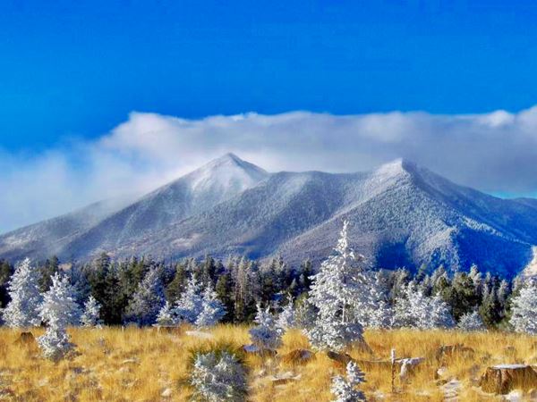
To the west you can see the snow capped summits of volcanic San Francisco Peaks around Flagstaff. These are relatively young volcanoes (6-million-years-old) and the highest one is Humphreys Peak which is the highest point in the state of Arizona (12,633 ft - 3.853 m).
Visit the Grand Canyon
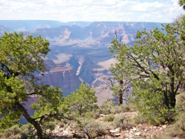
Tip: consider visiting the Grand Canyon on your Road Trip.
Some tours and sightseeing
Sponsored content
>> You can Book a Room at the Grand Canyon Railway Hotel in Williams
Grand Canyon National Park
World Heritage site of UNESCO
Lake Havasu City

Lake Havasu City, the lake and London Bridge. Source
The resort town of Lake Havasu City on Lake Havasu has beaches along the lake's scenic shoreline, an active nightlife and the original London bridge (you can take a Tour to visit it)
The adjacent state park is open 24 hs, and there is an entrance fee. It is located on a reservoir on the Colorado River. You can hike and enjoy the riverside.
Visit the scenic shoreline with beautiful beaches, nature trails, boat ramps, and many convenient campsites.
>> Book your Hotel in Lake Havasu City
Learn more about the outdoor sites in the Havasu State Park official website.
>> Book your Hotel in Winslow

Source
Credits for our composite image of the 1920s complex at Two Guns: Texaco Then,
Zoo then, Zoo now, Texaco Now
Banner image: Hackberry General Store, Hackberry, Arizona by Perla Eichenblat
Jack DeVere Rittenhouse, (1946). A Guide Book to Highway 66.
Gladwell Richardson, 1968, Two Guns, Arizona


