"The Italian touch on Route 66"
Index to this page
About Rosati Missouri
Facts, Trivia and useful information
Elevation: 1,074 ft (328 m). Population n⁄a (2024).
Time zone: Central (CST): UTC minus 6 hours. Summer (DST) CDT (UTC-5).
Rosati is a small unincorporated community located on Route 66 in eastern Phelps County, central Missouri in the Ozarks foothills.
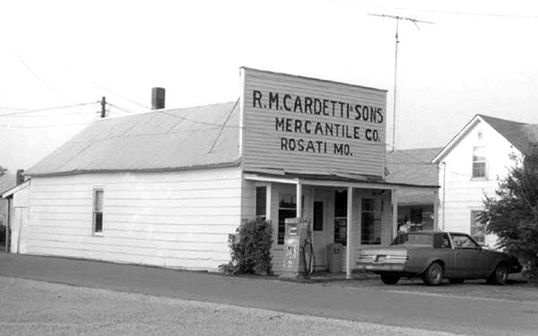
View of the old Cardetti store, Route 66 in Rosati, Missouri

History of Rosati
See our History of St. James, for a background on the history of the region.
Rosati was once known as Knobview, and was originally named in the 1840s for the three high hills resembling "Knobs" that could be seen just south of the settlement. The area was surveyed in the 1850s for the railroad and Thomas Kinsey Jr. opened the first store here in 1856; the site, which also had a post office was known as Kinsey's Station when the railway arrived there in 1860. The post office closed in 1882, reopened in 1893 and closed again in 1898.
At that time the area shipped out wood on the railroad, but the economy changed when Italian immigrants who had originally moved to Arkansas decided to look for more suitable land and in 1897 purchased it from the railroad, this established the Italian settlement in Knowbview (also spelled Knob View.
They were farmers and planted a New England variety of grapes (Concord) and raised apples, pears and other fruit as well as dairy products. This began the grape juice and wine industry in the area. In 1906, the St. Anthony Catholic Church was built, which continues to stand today.
In 1926 Route 66 was aligned just north of the town and that same year, on Nov. 25, a tornado hit the town destroying many buildings and injuring some citizens, the Cardetti Store was moved off its foundations. Shortly after (1931) the town was renamed "Rosati":
The Name: Rosati
The village was named afger the first Roman Catholic biship of St. Louis, Joseph Rosati (1826), he was the first bishop west of the Mississippi. The word is a patronymic or plural of Rosato (pink, rose-colored)
Route 66 provided additional income to the town and there were two service stations on it. In the early 1950s it became a four-lane highway, now under I-44. Rosati was bypassed and left to its own devices.
The Dioxin contamination
It was a local resident, Russell Bliss who sprayed the roads in many towns of Missouri with oil to control dust in the 1970s, what he did not know was that it was oil contaminated with dioxin -a very toxic chemical product. When it was detected by the CDC and reported to the EPA, all the contaminated soil was removed and taken to an incinerator located in Times Beach (a town that was so contaminated that its residents were moved out and the buildings demolished. Now it is a State Park on Route 66).

Find your hotel near Rosati
There are no hotels or accommodation in Rosati, but there are plenty of options in neighboring Cuba or St. James.
> > Book your hotel in Saint James
More Hotels & Motels along Route 66
There are several hotels in the area close to this town. Alternatively you can also find your accommodation along Route 66 in the neighboring towns and cities in Missouri. We list them below (from east to west):
On Route 66's Main alignment in MO
Eastwards
Westwards
- Hotels in Kansas
- Baxter Springs KS
- Galena KS
- Riverton KS
- Hotels in Oklahoma
- Miami OK
>> Check out the RV campgrounds in neighboring Rolla
Weather in Rosati

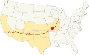
Location of Rosati on U.S. Hwy. 66
Rosati has well marked seasons, which are the combination of humid continental and humid subtropical climates.
The winter (Jan), the average high is around 39°F (4°C) and the aveage low is a freezing 20°F (-7°C). The summer (Jul) average high is 89°F (32°C) with an average low of 68°F (20°C). Rainfall averages 44.5 in. (1.130 mm) yearly which ranges from 2.21 in (56 mm) in Jan. to 4.81 in (122.2 mm) in May. Snowfall is around 18.9 in. (48 cm), which falls from Dec. to Mar.
Tornado risk
Rosati is located in Missouri's "Tornado Alley" and Phelps County is struck by 8 tornados every year.
Tornado Risk: read more about Tornado Risk along Route66.
Map of Route 66 in Rosati

USGS map of Rostati in 1938, Route 66 is shown in Red.
Route 66 from Fanning in the east to Rosati runs some distance away, to the south of the freeway. At Rosati it becomes the South Service Road.
Its course until it was realigned in the 1950s, ran very close to the railroad tracks in this area.
In the early 1950s a four-lane alignment was built next to it, from eastern St. James to Rosati, where it split, the old Route 66 became the eastbound lanes of the highway, all the way to Cuba, while a new set of westbound lanes were built from Cuba to Rosati (along the path of the modern I-44).
See this map of Route 66 in Rosati.
The Route 66 alignment in Rosati
Visit our pages with old maps and plenty of information about US 66's alignments.
- Rolla to Springfield (next)
- Gray Summit to Rolla (in Rosati)
- Route 66 in St. Louis (previous)
Route 66 Sights in Rosati
Rosati and its Route 66 attractions
Historic context, the classic Route 66 in Rosati
The 1941 book, "Missouri, a guide to the "Show Me" state" published by the WPA called it "... a sprawling community of small farm sites rather than a town" and mentions its Italian origin and its wines. It had 200 residents in those days.
Jack DeVere Rittenhouse does not mention it in his 1946 "A Guide Book to Highway 66" he did point out that there was a gas station 2 mi. west of it, and a station with cabins in what is now Rosati, without naming the town.
This leg of your Route 66 Road Trip: Rosati
Start on the eastern side of the community, driving from Fanning and heading west towards St. James. The "village" is 400 yards south of I-44 next to the railroad. There are ae few scattered buildings that make up the village. Here "Cardetti Store" once stood, until it was torn down.
Cardetti Store (gone)
At Hwy 268 in "downtown" Rosati, Missouri.

Peter Marchi Store ca. 1905, Rosati. Source
The old store, Cardetti & Sons Mercantile Co. is now gone, it was demolished in 2014. Its story begins in 1900, when Peter Marchi and A. Piazza open the first store in
Rosati.
It served as a school in 1901, and a post office after 1902.
In 1905 they dissolved their partnership; that same year Marchi opened another store (see photo).
It was later purchased by R. M. Cardetti (Pictured at the top of this page) who operated the store until 1949 when he sold it to his son, Joseph "Peno" Cardetti.
The store was hit by the 1926 tornado and it was moved off its foundations, but survived.
Nothing remains along Route 66...
The store closed in 1976 and its unsafe conditions led to its demolition in 2014. Fortunately another familiy member built a replica of the old store in neighboring St. James, the Leo Cardetti Flags & Flag Pole shop, pictured below.
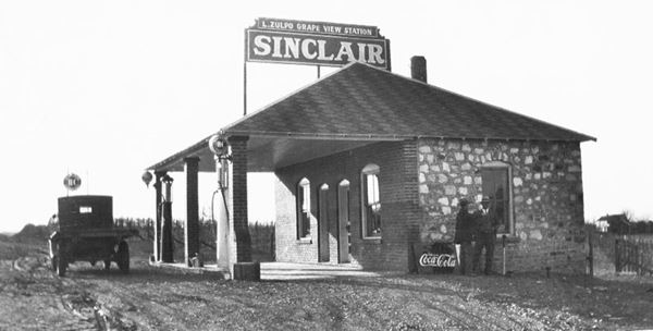
Along the old road alignment, little remains of the buildings along it. The former Zulpo's Grape View Filling Station opened by Louis Zulpo in 1929 is gone. It was the site of a Highway Robbery on July 20, 1930: four rookie gangsters from St. Louis stopped at the Knobview turnoff where the Zulpo station was located and robbed around $8. The bandits drove on to St. James while Louis Jr., 15, rang the police to inform about the robbery. Constable Peters caught them just outside of St. James.
The now gone Zulpo Station, Route 66 Rosati

Rosati Winery
Closed. At 22050 Route KK, Rosati (Map).
The Italian settlers planted grapes but these did not adapt, so they turned to an American variety, "Concord" grapes from New England. These were suitable for grape juice and sweet wines. The Rosati Winery opened in 1922, but the Prohibition had a negative impact on wine production as it was banned. After prohibition was repealed the winery prospered. World War II with its labor shortage and lack of sugar hit the wine industry and Cardetti closed the winery in 1942. Welch Grape Juice Co. bought the building and the grapes for jelly and jams it sold it to the US Army.
German Prisoners of War
German POWs worked in the plant during the war, brought by bus from Fort Leonard Wood (in St. Robert).
After the war it closed but reopened in 1971 only to close again in 1988. By then, the old grapes (used for juice or jam) were replaced by modern wine varieties and now Rosati has become a wine producing area with some 175 acres of grapes. Rosati Winery reopened in 2009 as a museum, gift shop and banquet hall. Then closed again.
4M Vineryards
Route 66, Rosati (Map showing location)
Visit their stand located on Historic Route 66 for fresh fruit, grapes, and more! (their Facebook page).
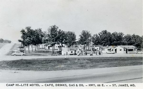
Site of the old Camp Hi-Lite
It was set on the nortwest corner of Route 66 and Hwy-U (Map) and razed in 1966 when the new I-44 westbound lanes were built, replacing the original 1950s 4-lane Route 66.
The complex had cabins and a gas station, it was built in the 1930s. It burned in 1950 and was rebuilt in 1954.
Over the years Bill "Shep" and Stella Shephard ran it, and then Netie and John Rutherford.
Below is a view looking north, Hwy U is on the left side of the image. Notice the card says "HWY. 66 E. -- ST.JAMES", no reference to Rosati, only East Highway 66 in St. James.

Nothing remains of it.
This part of your Route 66 Road Trip in Rosati ends here. Head west and continue your trip in St. James.

Some sponsored content
> > Book your Hotel in Lebanon

Credits
Banner image: Hackberry General Store, Hackberry, Arizona by Perla Eichenblat
Jack DeVere Rittenhouse, (1946). A Guide Book to Highway 66
Architectural - Historic Survey of Route 66 in Missouri and Detailed Survey, Maura Johnson. 1993


