"In the foothills of the Ozarks"
Index to this page
About St. James Missouri
Facts, Trivia and useful information
Elevation: 1,093 ft (333 m). Population 3,898 (2024).
Time zone: Central (CST): UTC minus 6 hours. Summer (DST) CDT (UTC-5).
The town of St. James is located on Route 66 in Phelps County, central Missouri next to the Ozarks Region.
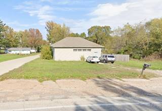
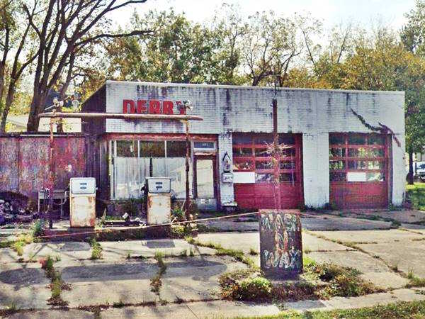
View of the Derby gas station in 2021, Route 66 in St. James, Missouri
History of St. James
People have lived in this area since the end of the last Ice Age some 10,000 years ago. The French explored the region in the late 1600s and named it after their king, Louis XIV: "Louisiana". Here, in the plains next to the Ozarks foothills they came across the Illinois Indians, an Algonquin nation who called themselves "Illiniwek" (men), this became "Illinois". They were hunter gatherers and farmed some maize, squash and beans next to their semi-permanent villages. Their homeland spanned Illinois, Michigan and northeastern Missouri. However like all Natives east of the Mississippi, they were forced by the Indian Removal Act to relocate (1830s) in the Indian Territories (which later became the state of Oklahoma).
After the Seven Years' War (1763) France ceded Upper Louisiana to Spain, recovering it during the Napoleonic wars. But in 1803, Napoleon sold it to the U.S. government, it was organized as the Missouri Territory in 1812 and in 1821 it became a state of the Union.
Thomas James from Chillicothe, Ohio and his patrner Samuel Massey began building the Maramec Iron Works in 1826, close to what would become St. James. Thomas' son William managed it after 1843.
Maramec Iron Works
Built there to use the hydraulic power from the river spring, coal made from the forest's wood and iron ore from a nearby mine. It was the First Iron Works in the US west of the Mississippi. The remains of the furnace can still be seen. The iron was used for plows, kettles and cannonballs. The foundry closed in 1876 and the mine in 1891.
The word "Maramec" is an Illinois Indian word for "catfish" or "ugly fish" (myarrameekwa), very common in thee river's waters.
In the meantime John Wood had reached the area (1859) and established a town on a prairie close to the Iron Works anticipating the arrival of the St. Louis-San Francisco Railway. It was originally named Big Praire and then Scioto (after Scioto Ohio, where many of its settlers had come from), however by 1860 it was known as Jamestown, and later St. James.
The Name: St. James
Named Jamestown after Thomas James, the Iron Works owner. They added "Saint" as there already was a post office with that name.
James is an English name derived from Latin Iacomus which cam from New Testament Greek "Iakobos": the Hebrew name Ya'aqov (Jacob), the name of two apostols.
In the 1870s Germans settled in the area and in 1897 Italian immigrants arrived, the town grew into a farming community. The main road from St. Louis to Rolla and Springfield (the "Wire Road") was improved in the early 1900s and became Missouri highway 14 in the early 1920s and in 1926 it was included in the alignment of U.S. Highway 66. At that time Mayme Ousley became the mayor of St. James, and was the first woman elected mayor of a town in Missouri (1921). Route 66 provided additional income to the town and only in 1956 was it realigned around the downtown area, bypassing it.

Where to Lodge in St. James, Missouri
The town has several lodging options and it shouldn't be difficult to find a room here.
> > Book your hotel in Saint James
More Hotels & Motels along Route 66
There are several hotels in the area close to this town. Alternatively you can also find your accommodation along Route 66 in the neighboring towns and cities in Missouri. We list them below (from east to west):
On Route 66's Main alignment in MO
Eastwards
Westwards
- Hotels in Kansas
- Baxter Springs KS
- Galena KS
- Riverton KS
- Hotels in Oklahoma
- Miami OK
>> Check out the RV campgrounds in neighboring Rolla
Weather in St. James
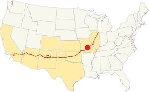
Location of St. James on U.S. Hwy. 66
St. James has well marked seasons, which are the combination of humid continental and humid subtropical climates.
The winter (Jan), the average high is around 39°F (4°C) and the aveage low is a freezing 20°F (-7°C). The summer (Jul) average high is 89°F (32°C) with an average low of 68°F (20°C). Rainfall averages 44.5 in. (1.130 mm) yearly which ranges from 2.21 in (56 mm) in Jan. to 4.81 in (122.2 mm) in May. Snowfall is around 18.9 in. (48 cm), which falls from Dec. to Mar.
Tornado risk
St. James is located in Missouri's "Tornado Alley" and Phelps County is hit by some 8 tornado strikes every year.
Tornado Risk: read more about Tornado Risk along Route66.
Map of Route 66 in St. James
Route 66 enters St. James from the east along KK Hwy (Historic Route 66), cuts across the town as shown in this map of Route 66 in St. James. Then it heads west along W James Blvd.
Its original alignment on the western side of the town is now cut by the freeway as shown in this map (green line) on the lower left side of the map.
Then it headed west towards Rolla along the North Service Rd. in the last leg of this segment.
The Route 66 alignment in St. James
Visit our pages with old maps and plenty of information about US 66's alignments.
- Rolla to Springfield (next)
- Gray Summit to Rolla (in St. James)
- Route 66 in St. Louis (previous)
Route 66 Sights & attractions in St. James
Landmarks and Places to See
"America's Dreamtown"
- A city tour of St. James (read below)
- Parks and outdoors
Historic context, the classic Route 66 in Saint James
The 1941 book, "Missouri, a guide to the "Show Me" state" published by the WPA described it as follows:
the business and commercial center of the Big Prairie. From here are shipped berries and truck and dairy products. Oak, hickory, cotton wood, and elm cut from the surrounding hills are here converted into staves. The town also has a small distillery and a women's garment factory. WPA (1941)
Jack DeVere Rittenhouse also mentions it in his 1946 "A Guide Book to Highway 66":
SAINT JAMES...garage; hospital; gas; cafes; courts: American Way and Kozy Kottage.) A Federal Soldiers Home is maintained here. The town holds a grape festival each September. This is the last community on the "plains"; soon you enter the Ozarks. Rittenhouse (1946)
City Tour of St. James
Start your tour on the eastern side of the town and head west along Route 66. It is a regular two-lane highway and passes from a rural to a suburban setting, homes by the side of the road and plenty of trees.
Vacuum Cleaner Museum & Factory
To your right, 0.5 miles north along Red Bird Rd - N Springfield St, is the Vacuum Cleaner Museum, see this Map with directions.
Private museum in a vaccum cleaner factory and store with a good collection of those appliances. Retrace your steps back to Route 66 and head west.
Atlasta Service Station

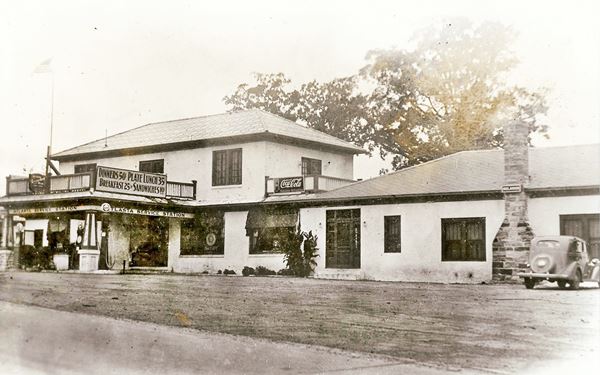
Atlasta station 1930s, Source
Two blocks ahed, to your right, on the NW corner of Mueller St. and Route 66. This building dates back to 191. It was built by Thomas Biles as the Atlasta Service Station.
It had a garage, tire shop, cafe, dance hall and even a banquet hall. During the late 1940s Bill Woodruff operated it and it was known as "Woodruff's Garage".
In 1964 the main station burned down but the adjacent tire shop survived, see it on the left side in the black and white picture above, this building is still standing.
1930s view of the Atlasta Service Station
Old Gas Station
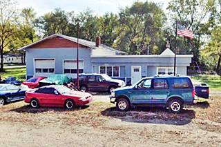
One and a half blocks west, to your left, at 320 E James Blvd (Route 66) is a former Route 66 gas station.
Now it seems to be a used car dealership. The gabled section to the east has two service bays and the flat-roofed section to the west was the office. You can still see the concrete pump island.
It appears in this 1955 aerial photo, in the middle, on the south side of Route 66.
Derby Service Station
Drive on, ahead, to your left on the SW corner of N Seymour St. and Route 66 is a vacant former gas station.
View of the Derby gas station in 2014, when it still had its sign
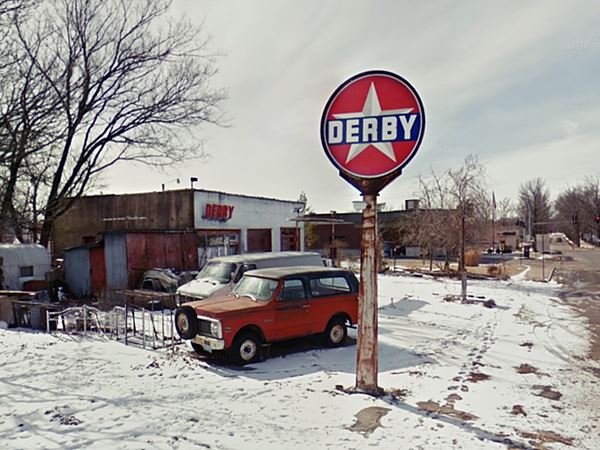

1960s view Derby gas station St. James MO. Source
Archibald Leon "Al" Derby (1875 - 1956) worked as a wildcatter, drilling oil wells and in 1917 moved to Wichita Kansas where in 1922 he formed the Derby Oil Company pumping oil, refining it and selling it through 100 gas stations in the region. He expanded the retail chain after WW II. The company was acquired in 1955 by Colorado Interstate Gas, in turn purchased by Coastal Corp. in 1973, who rebranded them as Coastal in 1988. See its current view pictured at the top of this page, with its sign gone!
Johnnie’s Bar
On the next intersection Route 66 meets N. Jefferson St., MO-8, here, to your left on the SW corner, at 225 N Jefferson St. is an old Bar and Cafe.
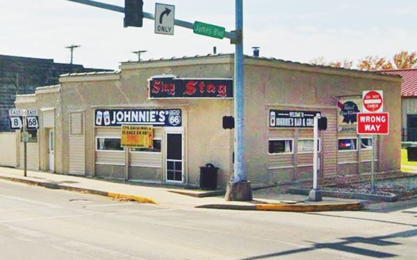
Known under different names as time went by: Rose Cafe, Commercial Cafe, Johnnie's Bar, this building dates back to 1929, just 3 years after Route 66 was created.
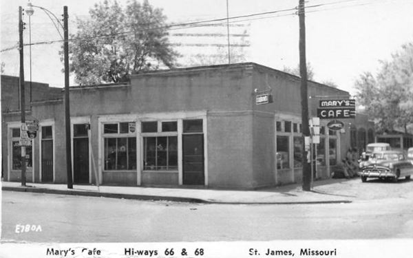
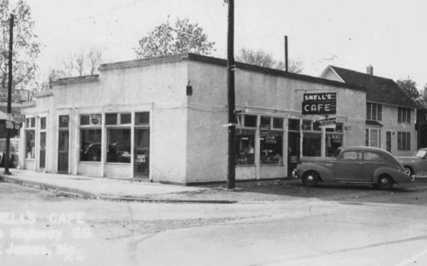
It has a flat roof and an L-shaped layout with stucco facing. It was first named Commercial Cafe and Jesse Rose owned it, hence the name "Rose Cafe". She ran it from 1929 to the 1940s, it was a cafe and restaurant. At some time during this period it was also known as "Snell's Cafe" (see picture further down).
It became known as the Rose Café. In the 1950s, as shown in the image below it was "Mary's Cafe". After the 1960s John Bullock purhcased it, and it became Johnnie's Bar.
Another picture, from the 1950s, when it was Mary's Bar
Same spot when it was Snell's Cafe, by the car, maybe in the 1930s
Leo Cardetti Flags & Flag Pole
Take a right along N. Jefferson St. to visit a replica building (to your left, across the road), the "New Cardetti" building (210 N Jefferson).
This flag store has the words "R.M. CARDETTI & SONS MERCANTILE CO. - Rosati Mo" written on its false front. This is a homage to the "old" Cardetti Store store in the neighboring Route 66 community of Rosati that Peter Marchi originally opened in 1905, selling it in 1913 to R. M. Cardetti who in 1949 sold it to his son Joseph. The store closed in 1976 and was demolished in 2014.
Turn around and take a left along Route 66 to head west.
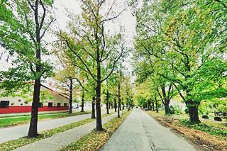
Scenic Divided Road Section
A very short (only 0.2 mile-long) section of W James Blvd. between N Jefferson St. and N. Jackson St., see this Map with directions.
Apparently this divided section was built because when the state bought the land for State Highway 14, its owner Mr. Pace insisted it become a divided boulevard with trees along its median.
This was the the first divided section of US 66 in Missouri.
American Way Motor Court or S & K Cottages
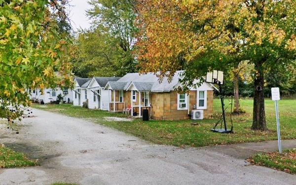
Drive west to visit the remains of a classic motel, to your left, on the south side of the street, the "S & K Cottages" also known as "American Way Motor Court".
At 712 W. James Blvd. (Map showing where it is.)
American Way Motor Court was built ca.1940 as a service station (now gone) with seven cabins built around it. They were "Modern heated cottages. Cool in summer". Below is a vintage color postcard. The wood cabins, and the stone cabin on the right (red arrow) and those on the left too, have survived. In the 1960s the place was run by Stanley and Katherine Kozlowski (hence the S and K name) as low cost rental.
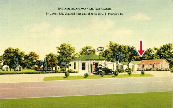
Surviving cabins at the American Way Motor Court in St. James, Missouri
As mentioned abouve Route 66 is cut by the Freeway and continues along its north side. To reach it, turn around head back to Johnnie's Bar and turn left along N. Jefferson.
Missouri Veterans Home
Just before you reach the exchange at the freeway, to your right is the "Soldiers Home" mentioned by Rittenhouse in 1946. It dates back to 1896.
On the opposite side of the road behind the Burger King and facing the freeway at the exit ramp is an old motel.
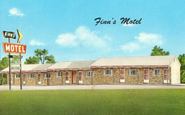
Finn’s Motel
777 Grover St. One block to your left, on the south side of the freeway.
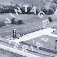
The old Route 66 became a four-lane freeway in 1956. It circled the town along its north side and was later replaced by the modern I-44. Motels were built here to cater to those driving along the "superhighway". Finn's can be seen in this 1962 aerial photo.
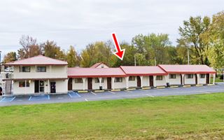
This late 1950s motel's postcard invited guests: "Rest with us tonight, to drive your best tomorrow". It was owned and operated by Roy Finn and his wife; the place had "Marvelous beds, very clean, free room T.V... individual thermostat control heat" and it is still open, though its neon sign has gone. The three stepped gable-roof buildings are still there (with the same door-sequence, from left to right: 2-3-3) on the western side of the complex (red arrow). The two-story office was added later.
Wines and Wineries
Cross I-44, and on the north side of the Interstate you can take a short detour eastwards (to your right) along the north Service Rd. (State Rte. B) for some wine tasting (of course don't drink and drive!) it is a short, 2 mi. round trip. See this Map with directions to visit two wineries.
St. James is part of the Ozark Highlands American Viticultural Area, and the first vines were brought by Italian immigrants in the late 1800s:
St. James Winery
540 State Route B. Learn more at their website.
Meramec Vineyards
600 State Route B. More details at their website.
Return to N. Jefferson and cross it to reach the North Service Road that heads west (Historic Route 66). You will leave St. James and head west towards Rolla.
Westwards towards Rolla
Begin your tour at I-44's Exit 195. was later replaced by the modern I-44. Motels were built here to cater to those driving along the "superhighway".
Greenstay Hotel site of Nickerson Farms
To your right on the NW corner of I-44 and MO-68 was the site of "Nickerson Farms, it was razed in around 1990 and now the Greenstay Hotel and Suites occupies the site. It wasn't a classic Route 66 hotel, but behind it is a classic! the old "Friendship Gateway Inn", later the "Ozark Motel".
Gateway Inn - Ozark Motel
Located at 118 North Outer Rd., the Friendship Gateway Inn is just west of the Greenstay, vacant, abandoned and overgrown (see its 2021 street view). It was built in the 1960s (after 1962) in a Space Age colored style (see postcard). It was part of the Friendship Inn franchise whose slogan was "Convenience - Integrity - Service". Its postcard tells us that it had It was built in the mid 1950s and had "25 large rooms, individual controlled A.C. & Thermo Hot Water Heat - Color TV... Restaurant next door." The adjacent restaurant was Nickerson Farms.
Then it became the "Ozark Motel" but it has undergone some changes over the years: The original two-story building had a gable roof over three stepped buildings perpendicular to the highway, with a swimming pool in the rear.
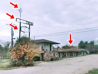
Below is a color photograph of them motel from the mid-1960s. Comparing it with the 2008 view of the hotel we can see (red arrows on the left) that the neon sign is the same one, almost unchanged with a star on the top now (and the Friendship Inn shield in the past), the word "MOTEL" in white plastic sqares across the upper part, and a hexagon shaped sign beneath it.
However, even though the stepped linear alignment was maintained, except for the front office the whole upper story was eliminated! the two-story Gateway Inn became a one story building!
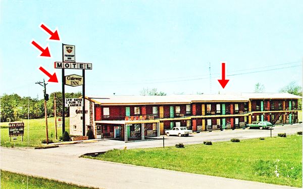
As you can see in this detailed 1987 aerial photograph, when it had become the "Ozark Motel", it had already lost its second floor yet had the same neon sign.
Continue west along the north service road towards Rolla. As you pass the Route 66 Pawn shop, here is where the original Route 66 coming along W James Boulevard headed out of town (now cut off by I-44). Just 0.6 miles ahead, to your right is the site of the old "Rock Haven Tourist Courts."
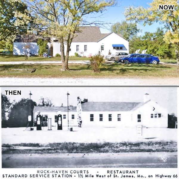
Rock-Haven Tourist Courts
N. Outer Rd, 1.9 mi. west of Exit 195. Map with directions.
The Rock Haven Tourist Courts and Restaurant also had a Standard Gas station. It is now a private residence that has maintained the original cross-gable appearance of the filling station. It was built in the 1930s (?), and bought by Frank and Ruth Waring.
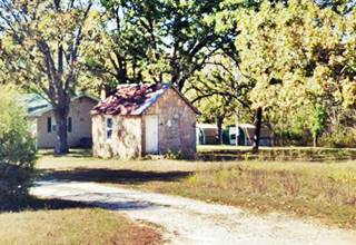
At one time six stone cabins stood on the property (one of them is still standing - see images below). They sold out in 1954 to Ruby Gilder. It was a nightclub in the 1970s.
View of the surviving Rock-Haven Courts' stone cabin and the original cabins in a vintage postcard:

Rock Haven stone cabins vintage postcard. Source
Murdon Neon Sign

Murdon neon sign. Source. Click for St. view
Head west and as you pass by Murdon Concrete products, enjoy a modern "classic" neon sign depicting a old dripping tap, that actually drips when lit up.
This video shows it at night, dripping.
Continue your journey towards Rolla, after 0.5 miles to your right is an old Route 66 motel.
Country Aire (old Dillon) Motel
Located at 13511 Old Highway 66, it is laid out in a semicircular pattern, facing the highway with a driveway in the center.
It started as Dillon Court, on "HSY.66, 5 MI. EAST OF ROLLA, MO" it had four cabins with two units each, and a central office. Later the cabins and office were integrated into one large semi-circle (see postcard) and it became the Country Aire, which had an RV park and campground. Below is a "Then and Now" set of images. Also check this 1987 aerial view, notice the swimming pool in the central courtyard.

Vintage postcard of Motel & RV Park, Source
Route 66 Motors
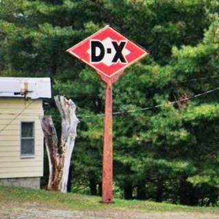
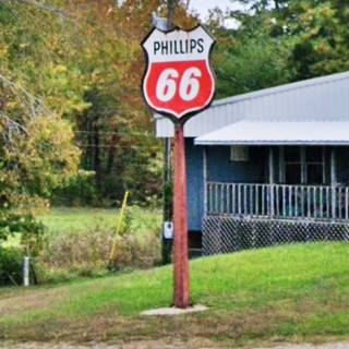
12651 Old Highway 66. >A 1950s gas filling station that became a souvenir shop, it later sold classic cars. If your into collectibles, this is a nice place to stop for some pictures. Don't miss the classic gas station signs.
This leg of your Route 66 Road Trip in St. James ends here, continue west into Rolla to continue your journey, or do some side trips here, in St. James.
Outdoor Parks near St. James
Natural Tunnel
The 1941 "Show Me" guide to Missouri mentions the "St. James Natural Tunnel, a passageway through a rock bluff, 150 feet long and 30 feet wide. A small sprinig rises from the tunnel's center and drains in both directions. In winter the tunnel is often used as a shelter for cattle". Based on the directions given in the book we place it here: location map.
Maramec Spring Park
6.9 mi SE along Hwy B, Map with directions.
The land for this private park, ran by a non-profit organization, was donated by Lucy Wortham James, granddaughter of Thomas James, the owner of the iron foundry. It has 1,860 acres of land and contains the state's fifth largest spring. Lean more at their website.
You can also see the Remains of the Iron works.

Some sponsored content
> > Book your Hotel in Lebanon

Credits
Banner image: Hackberry General Store, Hackberry, Arizona by Perla Eichenblat
Jack DeVere Rittenhouse, (1946). A Guide Book to Highway 66


