"America's Dreamtown"
The Mule Trading Post
Index to this page
About Rolla Missouri
Facts, Trivia and useful information
Elevation: 1,122 ft (342 m). Population 20,588 (2024).
Time zone: Central (CST): UTC minus 6 hours. Summer (DST) CDT (UTC-5).
The city of Rolla is the county seat of Phelps County, it is located on Route 66, in central Missouri next to the Ozarks Region.
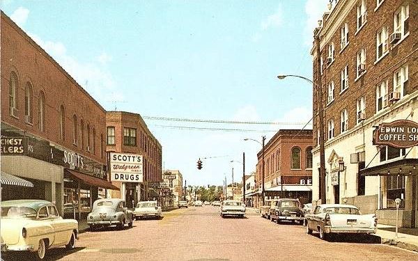
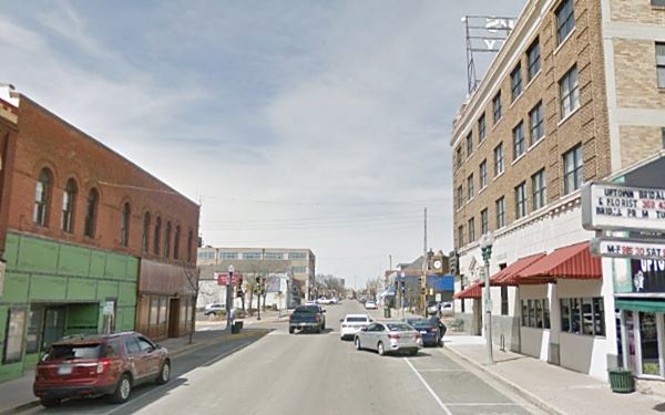
A set of "Now and Then" views along the Main Street in Rolla, old "City 66":
View of Pine Street in a vintage postcard, Route 66 in Rolla, Missouri
The same place today on the original Route 66 through downtown Rolla. Some changes but the main buildings are still there!
History of Rolla
People have lived in this area since the end of the last Ice Age some 10,000 years ago. Around 2,700 years ago, the Osage Indians were forced out of their homeland east of the Mississippi (Illinois and Ohio) by the Iroquois; they moved into Missouri and lived in the Ozarks.

U.S. 66 Shield in Rolla MO, Jimmy Emerson
Read about the Shields painted on Route 66
The French reached the area from Canada in the late 1600s and named the whole region after their sovereign, Louis XIV: "Louisiana". Trappers trekked the area which is now Missouri and explored it.
After the Seven Years' War (1763) France ceded Upper Louisiana to Spain but recovered it during the Napoleonic wars in 1800. Shortly after, a cash strapped Napoleon sold the territory to the U.S. government (1803). This part of Louisiana became the Missouri Territory in 1812 and it became a state of the Union in 1821.
White settlement encroached on the Osage, who were forced to cede their land in a serise of treaties of 1808, 1818 and 1825, that relocated them to reservation land in the Indian Territory, which later became the state of Oklahoma.
The first settlers in Rolla were farmers who arrived before statehood, ascending the rivers. John Weber built a home in what is now Rolla in 1844. The railroad survey began in 1845 and once it was done, Edmund W. Bishop arrived in 1853, to build the St. Louis-San Francisco Railway (Frisco Line), settling here too.
The county was created in 1857 and the county seat was to be founded in the central part of it, close to the railroad. Bishop offered 50 acres of his land and it was platted in 1859, becoming the county seat after an election in which it defeated neighboring Dillon (1861).
The Name: Rolla
The town's first name was "Phelps Center" and Weber liked "Hardscrabble", but it was George Coppedge, another settler from North Carolina who suggested the name of his hometown: "Raleigh", the
capital city of N. Carolina, but as Raleigh was hard to spell, the citizens accepted Coppedge's suggestion but had it spelled phonetically: Rolla.
Another -more credible- version is that the name was that of a character in Richard Brinsley Sheridan's operatic drama Pizarro, originally
called "The Spaniards in Peru; or, Rolla's Death. A Romantic Tragedy; in Five Acts" and, a very popular play in 1856, "Pizarro; a Spanish Rolla-king Peruvian drama. A burlesque, in one act" by Charles James whose main character was also the "Peruvian hero Rolla".
The town was occupied by Union forces in 1861, who built two forts there, a key place on the Wire Road. It became the main road between St. Louis and Springfield and during the early 1910s, it was improved, becoming in 1920, a gravel surfaced state highway (MO-14). Route 66 was aligned along it in 1926, and eventually it too was bypassed: by the four-lane highway in the late 1950s.
Getting to Rolla
You can reach Rolla along historic Route 66 and Interstate I-44 that links it with Springfield, Tulsa and Oklahoma City in the west and with Cuba, Eureka and St. Louis in the east. US 160, 60 and 65 run to the west, through Springfield, US 63 runs through the city.

Where to Lodge in Rolla, Missouri
Accommodation and hotels; there are plenty of lodging options in the city check them out:
> > Book your hotel in Rolla
More Lodging near Rolla along Route 66
There are several hotels in the area close to this town. Alternatively you can also find your accommodation along Route 66 in the neighboring towns and cities in Missouri. We list them below (from east to west):
On Route 66's Main alignment in MO
Eastwards
Westwards
- Hotels in Kansas
- Baxter Springs KS
- Galena KS
- Riverton KS
- Hotels in Oklahoma
- Miami OK
>> Check out the RV campgrounds in Rolla
Weather in Rolla
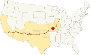
Location of Rolla on U.S. Hwy. 66
Rolla has well marked seasons, which are the combination of humid continental and humid subtropical climates. The winter (Jan), the average high is around 39°F (4°C) and the average low is a freezing 20°F (-7°C). The summer (Jul) average high is 89°F (32°C) with an average low of 68°F (20°C). Rainfall averages 44.5 in. (1.130 mm) yearly which ranges from 2.21 in (56 mm) in Jan. to 4.81 in (122.2 mm) in May. Snowfall is around 18.9 in. (48 cm), which falls from Dec. to Mar.
Tornado risk
Rolla is located in Missouri's "Tornado Alley" and Phelps County is hit by some 8 tornado strikes every year.
Tornado Risk: read more about Tornado Risk along Route 66.
Map of Route 66 in Rolla
Check out Rolla on our Missouri Route 66 Map webpage with the complete alignment across the state and all the towns along it.
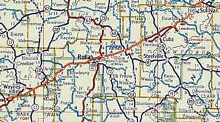
You can also click on the thumbnail image with the Shell road map published in 1956, it shows the alignment of Route 66 from Sullivan to Waynesville through Rolla (in the middle of the map). At that time the highway was mostly (except for the Cuba-Fanning section), a four lane highway, that preceded current I-44.
Alignments of US 66 in Rolla
Further down we describe the different alignments (1926, 1940s and 1950s, Main U66, and City 66) with maps.
The alignment near Rolla
Visit our pages, with old maps and plenty of information about US 66's alignments.
- Rolla to Springfield (next)
- Gray Summit to Rolla (previous)
Route 66 Sights in Rolla
Landmarks and Places to See
- In Rolla: City Tour (read on below)
- Route 66 alignments in Rolla
Historic context, the classic Route 66 in Rolla
The 1941 book, "Missouri, a guide to the "Show Me" state" published by the WPA tells us that 1 mile west of town, just beyond the railroad tracks to the left was a trail that led (0.6 mi.) to a "small iron mine... owned by the Missouri School of Mines and Metallurgy...". Further ahead (3.2 mi from town) was "Martin's Spring... enclosed within a squat stone house, with a daily flow of approximately 840,000 gallons."
Jack DeVere Rittenhouse mentions Rolla in his 1946 "A Guide Book to Highway 66" as the point where you leave the "plains" and enter the Ozarks. He described it as follows.
ROLLA... Major hotels: Edwin Long and Sinclair Pennant; courts: Colonial Village; Phelp's, Schuman's tourist City, El Caney, Trav-L-Odge, Winter's; Vance Motor Co. garage; all facilities...Rittenhouse, 1946
He also mentioned it was the site of the Missouri School of Mines and that there were two route alignments in the city: City 66 and "Main US 66 around the business district", he also mentioned Martin's Springs.
US 66 Sights in town
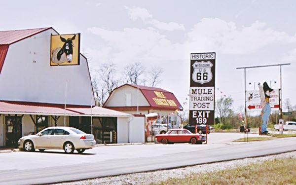
We will tour the town from east to west, starting at I-44's Exit 189, where we will visit the "The Mule Trading Post and Tobacco Barn". It is on the south frontage Rd., which was never part of alignment of Route 66.
Mule Trading Post
at 11160 Dillon Outer Rd (Map).
Frank Ebling opened the original "Mule Trading Post" back in 1946, in Gray Summit, close to Pacific, MO (pictured below), but when Route 66 was replaced by I-44 and bypassed his store, he moved west to Rolla in 1957 and opened a store on the frontage road of I-44 ⁄ Route 66 figuring it couldn't be bypassed.
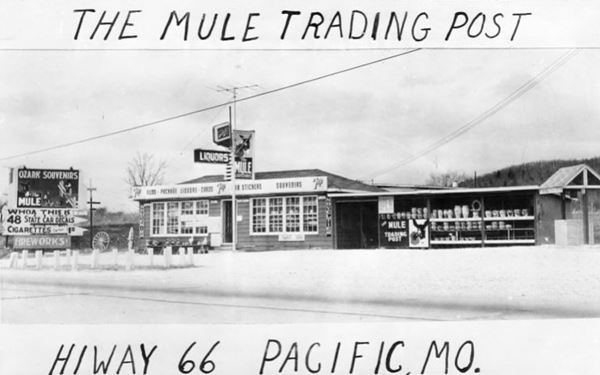
The frontage road at that time was linked to the main eastand westbound lanes -Route 66 at that time was a four lane divided highway without any overpasses. Only later did Dillon Outer Rd. become a dead end with only one access from the freeway at Exit 189.
In 1966, Herb and Joan "Jody" Baden bought it, and retired in 1997, Jack and Janiece Wittman ran it until 2007 when Carl and Zelma Smith took over. In 2018 it passed to Ryan Prock. Closed during 2020.
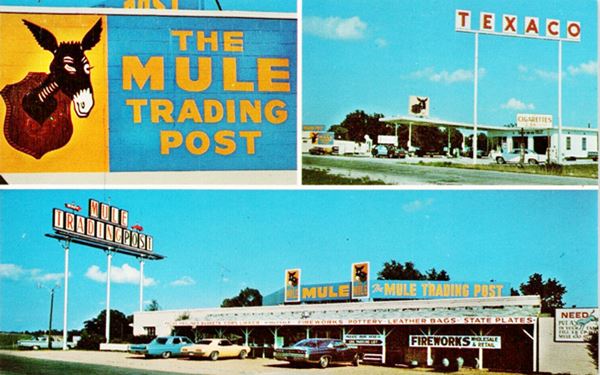
In the 1970s it sold Texaco gasoline (the poles of the sign are still there, on the western side of the Tobacco Barn), and had a flat roof and did not look like a barn, as it does nowadays. The adjacent "Tobacco Barn" is an extension of the Mule Trading Post, focused on tobacco products.
Hillbilly Sign
Route 66 Kitsch - Americana
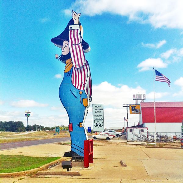
The "Hillbilly sign" you see in front of the store was originally part of the Sterling Hillbilly Store in nearby Hooker, Missouri. They had an 8-foot tall hillbilly over the entrance to the store but when they moved to Waynesville (close to MO-28 and I-44) in 1981 they had a new and gigantic sign made. This one measured 28 feet tall (8.5 m). It has arms that spin like the hands of a clock.
When Sterling's closed for good in 2000, the sign was sold. Carl and Zelma Smith tracked it down, restored it, and brought it back to Route 66 for a second life, at their trading post.
The "Hillbilly" at The Mule Trading Post
Into Town through Northwye
The original 1940s and early 1950s Route 66 is partly under the roadbed of I-44 (Read All about Old Route 66 alignment in Rolla), and is also on a dead end road, County Rd. 2000, cut off by the freeway.
So the north frontage road and County Rd. 39, were renamed as "Old Route 66" to let you drive along a similar course to that of the original highway. It lets you reach a suburb of Rolla called "Northwye". It is located at the strategic fork between US 63 and old US 66.
Former Phillips 66
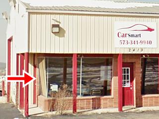
At 2419 Historic Route 66, to your right is an old Phillips 66 station, greatly modified, but the office with its upward slanted plate glass windows (red arrow) and the extant garage service bay tell us it was a gas station. It was probably a rock frame style station. It was built around 1960, so the time frame is correct.
At one time there was a Drive-In theater here to your left. Now Al West Nissan, an auto dealer occupies the premises; the screen was on the eastern tip of the property, next to the freeway.
Head west along US 63 and the "old 66", cross I-44 and then follow the Mother Road which turns towards the SW. Here is the 1970s Budget Deluxe Motel.
Vanishing Route 66
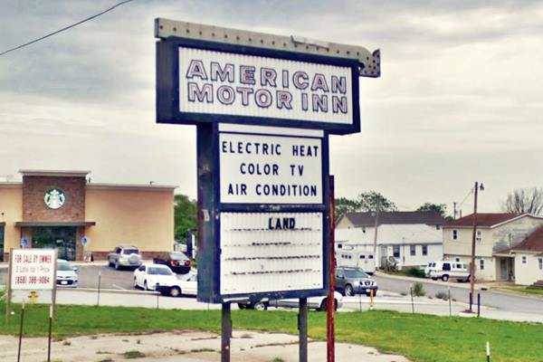
On the south side of the freeway there were several motels and gas stations, but all have been torn down. For instance there was an oblong box station where the Starbucks is now located see these then and now street views.
Next was the now razed "American Motor Inn" (image below) and the "Budget Apartments" (also torn down, see street view "then").
City 66
At Pine St. the City 66 forked to the left, and went south through the business district while the Main US 66 kept west and circled around the downtown along its western side, on Bishop Ave. Both branches met again on the southwestern side of Rolla.
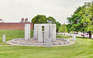
There are no classic Route 66 landmarks on the Main US66, and only one attraction worth visiting, a modern "Stonehenge Monument", it is
Stonehenge Monument
Americana and Route 66 landmark
It is 0.4 miles away, on the curve of Bishop Ave. North of University Dr., to your left, Map to get there.
Built in 1984 on the former University of Missouri at Rolla Rock Mechanics and Explosives Research Center. It is a half scale model of the famous megalith on Salsibury Plain in southern England, and has some of the features of the original Stonehenge.
The rocks were cut using water at a pressure of 15,000 lbs per sq.in. It has five trilithons. A trilithon is a structure consisting of two large upright stones and a third one acting as a lintel across them. They are 13 1/4 feet high (4 m).
It has a solar calendar or Analemma that marks the days on a stone.
Downtown Rolla Sights, Landmarks and Attractions
Retrace your steps and turn right along North Pine St. ("City 66") and Drive South. At 12th St. it becomes one way (south to north - in the Route 66 days it was a two way street), so you must take a right and then a left to head south along N. Rolla St.. Park and walk along 8th St. to Pine St. to visit a Historic Hotel
Edwin Long Hotel
Listed in the National Register of Historic Places
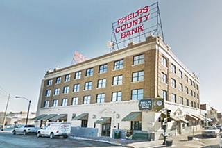
On the corner of Pine and 8th St, at 718 Pine St. The hotel closed in 1971 and it has housed the Phelps County Bank since 1963 (formerly the National Bank of Rolla).
It opened in 1931 as the Edwin Long Hotel; Route 66 was just paved that year and it was named after Sen. Edwin Long, a local community leader.
The signs on its roof once read "HOTEL". Built by M. Gillioz, it still is the largest building in downtown Rolla, with 4 floors. It has a Renaissance Revival style. Below is a "Now and Then" set of images of the hotel.

Vintage postcard of the Edwin Long Hotel, large image
Head south, at W. 6th St. you will cross City 66 (two lanes) as it heads out of town. Continue straight, cross the railroad and take a right on W 3rd St. to visit the Log Courthouse.
Dillon House: "Log Courthouse"
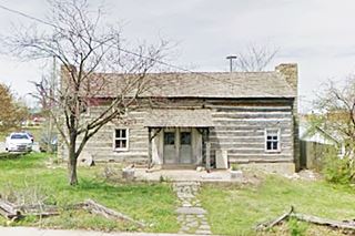
W 3rd St. between N. Rolla and N. Main St., to your right, on the north side of 3rd St. This one story log building with stone chimney was built in 1857 and was the county's first courthouse. Walk one block west, to Park St. to visit the "Old Jail".
Phelps County Jail
Listed in the National Register of Historic Places
On Park St. and W 2nd. St. The old historic Phelps County Jail was built in roughly hewn stone quarried locally, in 1860.
Take US 63, and turn left along Kingshighway. This is where Main 66 and City 66 met. Just ahead to your right is Buehler Park.
Buehler Park
The park has very old trees and was deeded to the city in 1958. It is named after Dr. Henry Andrew Buehler, Chief Geologist of the Missouri Geological Survey. Across the road from the park is a "Classic Route 66 motel".
Sunset Inn, old Norman Dee Motel
To your left, on the south side of the highway is this classic Route 66 motel. The postcard shown below tells us that it was owned and run by Joe and Ruth Pawlak, and that it was "New, Attractive,opposite park, easy off-on interstate, Air conditioned color TV, phones, family units, cafe adjacent..."
The comparison of its postcard and its present appearance show us that the pool has gone but the building has kept its general layout intact.

Vintage postcard of the Norman Dee Motel, Source
Next to it was the now razed "Coach House Inn" with "54 modern units... quiet, Color cable T.V. Direct dial phones...". It later became the Days Inn, but has been torn down (a vintage postcard of the motel).
Head west along Route 66, pass the roundabout and take Martin Springs Drive. This was the original Route 66. To your left is a Classic Route 66 Trading Post.

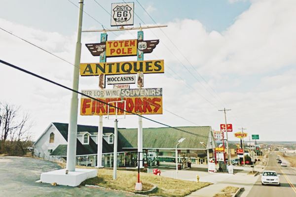
Neon Sign of the Totem Pole Trading Post.
Click for St. View. Source
Totem Pole Antiques
1413 Martin Springs Dr. It claims to be the "longest-running Route 66 business in Missouri".
It first opened in 1933, in Newburg (Totem Pole Cabins -now demolished) and was owned by H. Cochrane who later sold it to Ralph Jones around 1950.
At that time the old Route 66 was widened to a four-lane road cutting off some properties and in 1967 it became I-44, cutting off even more properties from the highway. This led Jones to relocate near Rolla (15990 County Rd 8140), now an auction house.
Nowadays it is on the "loop" of old Route 66 north of I-44, cut off frmo the freeway, just east of Doolittle. He had to move again when he was cut off from his customers. He moved to this location in Rolla, in 1977. It is still open, but now the property is for sale.
Head west along Martin Springs Dr. to visit the "Springs" and a former "Route 66 gas station and store".

1951 USGS Map of Martin Spring
Martin’s Spring
According to the USGS map it is "Spring" without the "s", but the MODOT says it is "Springs" with an "s". The site is 1.9 miles West of Totem Trading Post in Rolla, see this Map showing location.
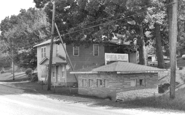
The property is listed in the 1993 Architectural - Historic Inventory Survey of Route 66 in Missouri, where the picture below was taken from; the sign on top of the bath house says "Martin Springs". This is its current appearance (unchanged).
It was built on the original 1926 Route 66 alignment, and later in 1951, when US66 was straightened out and became a four-lane highway, it was at the junction of both "old" and "new" alignments. However, when US-66 became I-44, and the interstate became a limited access freeway, it was cut off from it, as it is nowadays.
Martin Springs Store
The store was located on the ground floor of the hipped roof, wood frame two-story building to the left of the old rock-faced spring-house (Foursquare style) it was built c. 1920s.
This was a dairy farm known as Bloom farm. The store owned by Bill and Emma Martin (the place is named after him), they sold gasoline and had some cabins, now a private residence.
Springhouse
Squat stone-faced one-story building with small windows and hipped roof. was built around 1920, you can see the water flowing out of it, towards the Little Beaver Creek.
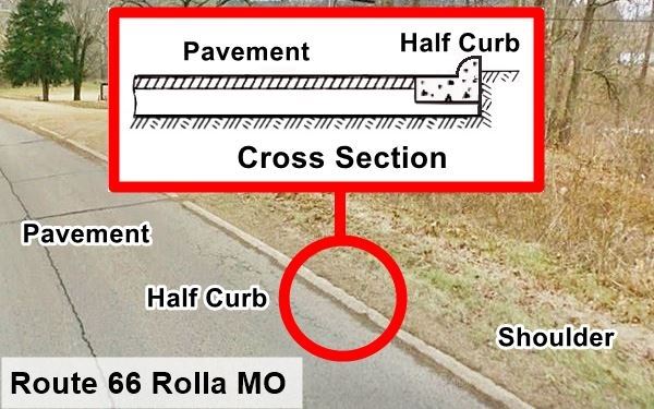
Half Curbs segment of Route 66
This segment of Route 66 was originally a gravel surfaced road. It was paved in 1931 and a new idea was tested on it, "Half curbs". The idea was that these semicircular flat curbs would help keep the cars on the roadway, acting as a physical barrier to keep them from deviating from the road on curves, and also from wandering off the roadway onto soft shoulders. They were also used on Route 66 in Canute OK.
The idea didn't work. The low curbs actually tipped cars over, causing rollovers and more accidents than they prevented.
This marks the end of your city tour through Rolla. Head west and visit Doolittle.
Old Route 66 in Rolla
Alignment's History
The first trail in the area was opened by deer and buffalo, and later used by the Native Americans, this trail or "Indian Trace" followed the divide in the Ozarks. After the late 1600s, European explorers and trappers followed it; they named it the "Great Osage Trail" (after the Osage Indians).
In the 1860s a road was built along this trail to aid in the construction of the military telegraph line. This dirt road was known as the "Wire Road"; it became the main road between Springfield and St. Louis.
During the early 1910s, cars became more frequent in the Ozarks but the roads were full of potholes or muddy traps during the rainy periods. The Inter-Ozarks Highway Association
lobbied successfully for a decent state highwy and that is how MO-14 was built between Springfield and St. Louis, and given a gravel surface.
Route 66 was aligned along it in 1926, and in Rolla, it was unpaved.
Route 66 into Rolla from the East

1928 USGS Map east of Rolla
Dead Man's Curve east of Rolla
Coming from St. James, the original 1926 highway was a two-lane gravel road, it ran along what is now the north frontage road of I-44, known as Historic Route 66.
Just after passing the site marked with a Benchmark as "Dunivin" (see the 1928 USGS map), it curved sharply with a 90° curve, to the north (red arrow) and headed along what is now County Rd. 39 then it curved widly to enter Rolla - see blue arrows. (Map 1926 alignment), the dead man's curve is now under I-44 at the eastern tip of this alignment.
We marked it with a red line in this Map of the Dead man's curve.
This was later straightened out. By the 1940s, as it approached Rolla, it followed a softer curved alignment, one that is now cut by I-44. You can see it as the orange line in Map of US66 east of Rolla. This map is based on the 1949 USGS Map of Rolla and US highway 66, notice that at that time it no longer followed the current "Historic Route 66" - County Rd. 39; instead it took the now cut-off County Rd. 2000. The alignment that can be driven into Rolla is shown in this Map into Rolla, from Co. Rd. 2000 to N. Pine St.
City 66
The original 1926 alignment of US 66 in town went along Pine Street, with traffic flowing in both directions. This congested the downtown area so soon the westbound traffic was moved to N. Rolla St. (City 66 map.)
Main 66
During the 1940s a bypass was built, around the business district along Bishop Ave. (Main 66 map.)
This map (click thumbnail for full size large map) shows the 1949 alignment from Northwye across Rolla.
1950s Four Lane Alignment
Both routes were bypassed in the 1950s by the four lane Route 66 that was a divided highway yet didn't have overpasses and limited access. This old roadbed is now buried under the roadway of I-44.
1966 New roadbed
Beginning in 1967 the old US-66 ⁄ I-44 Freeway was improved again. Eventually the whole of US 66 in this area was upgraded into a four lane limited access highway and after 1958 it coexisted with the new interstate I-44 (a state petition in 1962 to name the highway I-66 was denied by the AASHTO). Finally in 1972 the whole of Route 66 had been replaced by the freeway and in 1974 it was decided that the whole of US 66 from Chicago to Joplin would be eliminated. However this was delayed until I-55 in Illinois was completely brought up to Interstate standards. The signs were removed in 1977 but the last segment of the old Route 66 was bypassed in 1981. The road was decertified in 1985.
From Rolla west into Doolittle
Dead Man's Curve west of Rolla
The original road is now Martin Springs Drive, just ahead, after Martin Springs the original 1926 road curves sharply towards a very narrow bridge on a curve (Map showing curve). The old Beaver Creek Bridge built in 1926 was recently replaced by a modern one (June 2021). From here it heads into Doolittle (map)
This "Dead Man's Curve" plus the narrow the Beaver Creek bridge were very dangerous, causing frequent automobile wrecks.
> > See the previous segment St. James to Rolla (east)
> > See the next segment Doolittle to Newburg (west)
Some sponsored content
> > Book your Hotel in Lebanon

Credits
Banner image: Hackberry General Store, Hackberry, Arizona by Perla Eichenblat
Rolla, The Ramsay Place Names File
Architectural - Historic Survey of Route 66 in Missouri, Maura Johnson. 1993.
Jack DeVere Rittenhouse, (1946). A Guide Book to Highway 66.


