Your Route 66 Road Trip through Jerome
Index to this page

TheRoute-66.com is reader-supported. When you buy through links on our site, we may earn an affiliate commission at no additional cost to you.
About Jerome Missouri
Facts, Trivia and useful information
Elevation: 694 ft (212 m). Population n⁄a (2010).
Time zone: Central (CST): UTC minus 6 hours. Summer (DST) CDT (UTC-5).
Jerome is a small town that is located one mile north of Route 66. At one time there were some scattered buildings along the Mother road, of which now only some vacant and derelict remains of U.S. 66 resorts have survived.
Jerome is located on the western side of the Gasconade River, in Phelps County, Missouri.
History of Jerome
Check our page with the History of Rolla and Phelps County to learn about its early history.
The state legislature created the county in 1857 and named it after John S. Phelps (1814-1866) congressman and state governor (1876).
The "Wire Road" was built in the 1860s next to the telegraph line that linked St. Louis with Fort Smith in Arkansas and passed close to what would become Jerome. In 1867, the St. Louis and San Francisco railroad built a line west of Rolla through Arlington and across the Gasconade River into Jerome.
A town was platted around the station and initially named "Fremont" by W. Greeley (who was directed by General John Fremont). But later, when settled by Catholics, it became Jerome.
The name: Jerome
Saint Jerome (Eusebius Sophronius Hieronymus); ca347 – 420 AD. Priest, confessor and theologian born on what is the border of Italy and Croatia in Emona. He translated the Bible into Latin.
It was a summer resort on the river and remained an unincorporated community until today, facing Arlington, on the eastern side of the river.
In the 1910s, State Highway 14 was created because cars had become more popular and required better roads. The highway crossed the Little Piney River next to Arlington over a bridge built in 1923. MO-14 was made part of U.S. 66 in 1926 and paved by 1931. Route 66 does not go through Jerome itself, only a fringe of the village's southeastern unpopulated area.
During the early 1950s, Route 66 was upgraded into a four-lane freeway and later it was improved to Interstate standards this impacted on the business that catered to traffic on the older alignment.

Where to Lodge in Jerome, Missouri
There are no hotels in Jerome or neighboring Arlington, but you can find many lodging options on Route 66, nearby,in Rolla.
> > Book your hotel in neighboring Rolla
More Accommodation near Jerome along Route 66
There are several hotels in the area close to this town. Alternatively you can also find your accommodation along Route 66 in the neighboring towns and cities in Missouri. We list them below (from east to west):
On Route 66's Main alignment in MO
Eastwards
Westwards
- Hotels in Kansas
- Baxter Springs KS
- Galena KS
- Riverton KS
- Hotels in Oklahoma
- Miami OK
>> Check out the RV campground in Jerome
Weather in Jerome
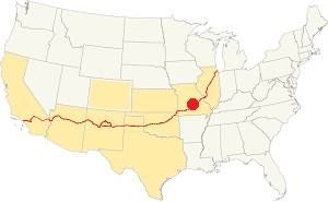
Location of Jerome on U.S. Hwy. 66
Jerome has warm summers: the average summer high (Jul) is 88°F (31.2°C) and the average low in 67°F (19.2°C). Winters are cold; the (Jan) average high is 42°F (5.6°C) and the average low is 20°F (-7°C), below freezing.
Rainfall is around 44.5 in (1.131 mm) yearly and snowfall averages 9 in. (23 cm), falling from Dec. to Mar.
Tornado risk
Jerome is in the "Tornado Alley" and Phelps County, Missouri has around 8 tornado hits per year.
Tornado Risk: read more about Tornado Risk along Route66.
Map of Route 66 in Jerome
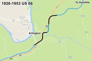
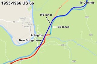
The alignment of U.S.66 in Jerome has changed over the years. We describe it in detail in the Arlington - Jerome segment of Route 66 in the Rolla to Springfield alignment webpage.
We can summarize it as follows:
- From 1926 to 1953 Route 66 was a two-lane highway followed what is now the North Outer Rd. and the alignment (now gone) marked in Black in this Jerome alignment map.
- In 1953, south of the Little Piney River a new highway was built (straighter) on the eastern side of the old one; it carried the eastbound (EB) lanes (shown in blue in the map), it met the old alignment by the bridge and east of this point the old US66 became the EB lanes of the 4-lane highway.
North of the river, another new highway was built on the west side of the old alignment, it carried the westbound (WB) lanes (shown in red in the map), and on the south side of the river it was linked to the original US66, that became the WB lanes of the new 4-lane highway. - The old 1923s bridge on the EB lanes was replaced in 1967, and at that time what are now I-44's WB lanes were built, leaving the original US66 in Jerome as the North Outer Rd.
This is the map showing how to reach Jerome's Route 66 nowadays (you must use the freeway).
The Route 66 alignment in Jerome
Visit our pages with old maps and plenty of information about US 66's alignments.
- Springfield to Joplin (next)
- Rolla to Springfield (in Jerome)
- Gray Summit to Rolla (previous)
Route 66 Sights in Jerome
Landmarks: Ruins in the forest
Historic context, the classic Route 66 in Jerome
The 1941 book, "Missouri, a guide to the "Show Me" state" published by the WPA tells us that 0.5 mi west of Arlington was "... County D, a graveled road... crossing the clear, gravelly Gasconade River to Jerome... a sprawling fishing resort". Followed 0.3 mi. west by "Stony Dell (Cabins, picnicking, swimming)... typical of many privately operated resorts that have sprung up beside Ozark Highways".
"A Guide Book to Highway 66" published in 1946 by Jack DeVere Rittenhouse also tells us that 1 mile west of Arlington was a small resort.
Stonydell, a popular Ozark resort, has several stone buildings, including a gas station and the office of its Justice of Peace. Store and several cabins, also a swimming pool Rittenhouse (1946)
He added that it was followed by a 1 mile-long climb and after another mile, a "Cafe and a few cabins".
Now only ruins remain of these buildings, they died when Route 66 was replaced by a faster moving freeway in the 1950s and by the realignment of I-44 after 1967.
Your Route 66 Road Trip drive through Jerome
Head west, along the freeway, coming from Arlington and heading towards Powellville. Leave I-44 at Exit 172, and take a right along N. Outer Rd. (towards Jerome); drive 0.4 miles to visit the site of Stonydell. See this Map with directions.
Stony Dell or Stonydell
On old Route 66 (Hwy. D) mile marker 172, Jerome. Location map.
Below is a map of the site,
The buildings on the north side of the road (shown in yellow in the map) are still standing, some in an abandoned state. Those on the south side of the highway (shown in hW in the map) have all gone, except for the artesian well.
The name in the 1993 Missouri Survey is "Stonydell", but the advert published in 1937 (below) says "Stony Dell" as two words. We will use both names for the same site.

Layout map of Stony Dell Resort. A. Whittall

Stonydell advertisement, 1937-08-12. Credits
Stony Dell Cabins and Arlington Schoolhouse
These cabins are located on easternmost part of the complex, on the north side of the road (shown as yellow squares in the site's plan further up). Turn around when you reach them and head west, stopping along the way.
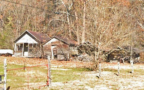
There are several wood frame and log buildings with tin gabled roofs. They were built around 1935. There are four cabins in poor condition, facing a grassy lot.
They run perpendicular to US 66 with a line of trees behind them. The largest building is said to be Arlington's school (the 1951 USGS map shows it as such).
Above is a picture of the cabins nowadays, Old School is on the left.
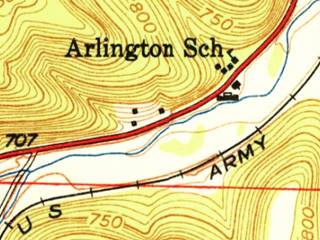
1951 USGS map of Stonydell in Jerome
What is a Dell?
Regarding the School, according to the 1993 Architectural - Historic Survey of Route 66 in Missouri, a local resident named Ruth Corder informed that "the area where it is now located was once known as Tater Holler." (Where Holler is a deformation of the ral name, "Hollow").
Stony Dell gets its name from this hollow or dip in the terrain because the word comes from Old English "dell" that means "hollow" or "dale".
The 1951 USGS map shows the school building on the north side of Route 66 (you can see the Stonydell pool and store on the south side next to the stream. The four lane Route 66 hadn't been built at that time, it would run along the empty space between the creek and the railroad.
Water Dispenser or Gasoline pumps island?
In the tiny grassy field, next to the fence you will spot a long concrete slab with semi-circular rounded tips and with two circular holes along the central axis.

Concrete pump island in Stonydell, credits. Click image for street view

Arch and Water pumps, Stonydell, credits
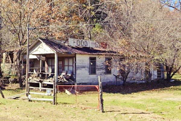
The original gas station in Stonydell stood on the opposite side of the highway, beside the swimming pool. There seems to have been another gas station next to the cabins, because the sign on the roof pitch of the building west of the cabins, the Bear Den, says "GAS Food Baits Handmade Gifts", so perhaps it was the island of this second gas station.
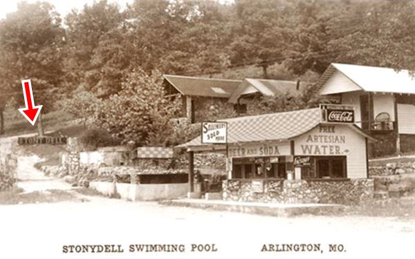
The 1930s black and hW picture shows the water pumps (red arrow right), but they were closer to the arch (red arrow left) on the western side of the complex, where the now derelict bus stop was located. You can make out two pumps under the gabled roof with the "Water" sign on it. Perhaps it was moved when the bus stop was built?
Stony Dell Bushwacker's or Bear Den Store
This building is on the western side of the field, after the pump island. It combines two separate buildings under one single roof. Built with a wood frame and gabled roof it has a full porch overhang. It dates back to 1935. It is shown in the image below.
Stonydell Bus Station or Granny's Vittles

2009 and 2021 views of the old bus stop, Stonydell, Route66
The building is a wood frame with stucco plaster. It has stone walls and a gabled roof with concrete stoop along its facade. There was a fish pond on its western tip. It was built in two phases ca 1935. It served as a restaurant, curio shop and also as a Trailways bus station during the 1930s. It is the westernmost building in the complex along the north side of the highway, and has slowly fallen apart. See the image and these street views: 2009, in good shape, but 2021, very deteriorated.
Behind the old bus stop, on the terraced hillside slope, and extending towards the west are the ruins some stone cabins (shown in gray in the layout plan).
There were eight of them, built with random rubble stone, the archway to the right and the retaining wall were also built with local stone.
The image below shows the stone archway (red arrow, left) with the "Stony Dell" sign on it, the cabins on the hillside and the first building that housed the Bus station and curio shop (right). Notice how the postcard locates it in neighboring Arlington.
Cabins, arch and Stonydell bus stop in a vintage postcard in Jerome, Missouri
Stone Archway
The stone archway and the retaining walls are still standing, on the right side of the highway, hidden in the bushes and trees (street view).
Site of the Swimming Pool
Ahead, to your left the shoulder widens into a large gravelled parking area. This is the site where the original store, gas station and famous swimming pool once stood.
History of the Stonydell Complex
The original building on the site was a two story gable roof store, the Hi-Wa Trading Co., General Merchandise. Then, in the early 1930s, George Prewett acquired the property and expanded it into a sprawling tourist resort.
In 1935, the Rolla Herald described it as "one of the beauty spots of Phelps County" and Rittenhouse also mentioned it as "a popular Ozark resort".
George and his sone Vernon were stonemasons, and built many of the buildings in the complex, they were assisted by George Badger a carpenter.
The buildings on the south side of the highway (all gone, shown in hW in the plan further up) included a large rectangular shaped swimming pool, a two-story bath house built in stone next to it, a restaurant, picnic grounds, stone fountain and a garden.
The Prewetts sold it in 1954 to Fred Widener, who ran it until 1967. But by the 1960s it was already ageing. Traffic still drove by, but its best days had passed. I-44's realignment in 1967 doomed it, the southern side of the property was razed when the new westbound lanes were built. Stony Dell closed for good and was torn down. You can see it on the south side of the highway in this 1955 aerial photograph, notice how at that time there were two lanes where I-44 is now located, they carried the eastbound lanes of Route 66.
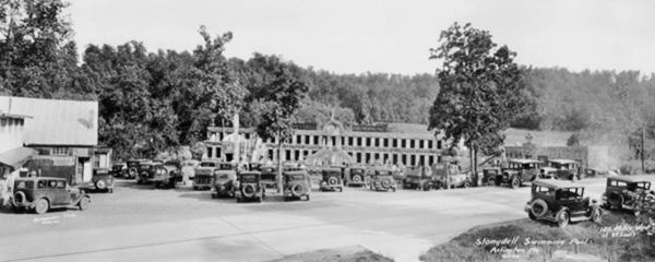
The image below (click on it to enlarge it) shows the store, restaurant and gas station on the left, the bath house is the long two-story stone building in the middle. The swimming pool is located between the bath house and the parked cars. Route 66 runs across the foreground of the image. The stream and the artesian well are behind the bath house (now modern I-44 runs across that area behind the complex).
Looking south towards the swimming pool at Stonydell. Rolla is to the left, Waynesville to the right.
Artesian Well
Stony Dell was was built next to an artesian well that provided fresh water for its pool; it was also bottled and sold at the resort's gift shop and there were two pumps on the north side of the highway that dispensed water.
Artesian wells are found in dips in the terrain in hilly areas where the upper layer of rock is permeable (like sandstone for instance) and allows rainwater to seep through into the aquifer. Downhill from the water recharge area, the water is confined between impervious layers of rock, the difference in height between the well and rechage area pressurizes the water. The weight of the overlying strata also exerts pressure on the water.
When the impermeable layer is perforated by a well, the hydraulic head drives the water upward and it flows without the need of pumping into the well. Depending on the pressure, water can even flow out of the well, as it did here, in Stonydell.
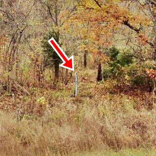
The old well is still there, and there is a steel pipe jutting out of the ground, very close to the freeway (red arrow image below). The blue pipe caps the well and has a Route 66 shield painted on it wit the words "Stony Dell est. 1931" written on it. Water pours out of the top of the pipe. You can reach it from the old highway by walking through the underbrush and crossing the stream.

Artesian well (read text for explanation). A. Whittall
Happy Hill Cafe
Head west, and just ahead, to your right is a Former Café. 0.2 mi. west of Stonydell (Location Map).
Happy Hill Café while it was still standing (2009)
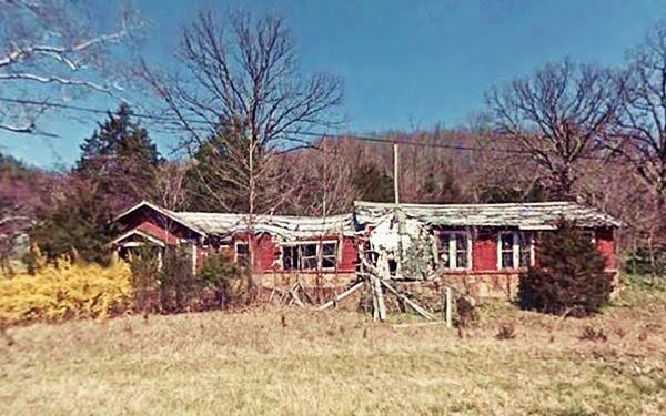
Also known as the "Happy Hill Restaurant" and much later as the "Honey & Hot Biscuit Cafe". It was a long and narrow building with a gable roof.
It was built into a hillside ca. 1945. and it served as a second restaurant for those who stopped at Stonydell. Ruth Laws owned it in the 1950s.
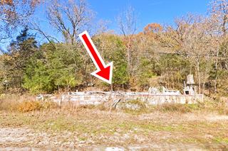
Over the years it fell into disrepair, and now is just a pile of rubble next to the highway (see picture, red arrow).
Next to it is the "Larry Baggett Trail of Tears Memorial".
Larry Baggett Trail of Tears Memorial
Brief History of the Trail of Tears
The Indian Removal Act of 1830, signed by President Andrew Jackson defined the fate of five Indian Nations: The Seminole, Creek, Choctaw, Cherokee, and Chickasaw. They were forced to relocate from their territories in the east to a new home in the "Indian Territory" (which later became Oklahoma) where they had been assigned reservations.
The Act's goal was "remove" all Native Americans from the states east of the Mississippi River.
Trail of Tears, the red arrow marks Stony Dell (between Rolla and Springfield MO).
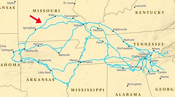
This forced migration with little support or logistics caused the death of thousands of unfortunate Indians due to illness and starvation. The route these ill-fated people followed is now known as the "Trail of Tears", a name that hints at the hardship they had to endure on their death march.
The worst hit were the Cherokee who had contested the measure in court. But in 1838 they too had to march west and wer forced to trek west.
The Trail is protected by the National Park Service, and you can visit the NPS website to learn more about it.
Larry Bagget's Memorial
Larry Baggett (1925 -2003) purchased a plot of land on Route 66 to build a campsite but, instead, he ended up building his tribute to the Trail of Tears.
To your right, you will see a statue of Baggett; there are many stone walls and rock gardens, and a rough rock archway with the sign that reads "Trail of Tears".
Trail of Tears memorial in Jerome, Missouri
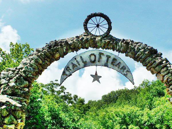
See a street view of the archway and entrance to the site, seen from Route 66.
This marks the end of the tour through Jerome, you can continue your Route 66 road trip by heading west along the Mother Road to visit the next "town", Powellville.

Some sponsored content
> > Book your Hotel in Lebanon

Credits
Banner image: Hackberry General Store, Hackberry, Arizona by Perla Eichenblat
Jack DeVere Rittenhouse, (1946). A Guide Book to Highway 66
Missouri: The WPA Guide to the "Show Me" State (1941)
Architectural - Historic Survey of Route 66 in Missouri and Detailed Survey, Maura Johnson. 1993


