Ghost town on Route 66
Vintage cars, a Route 66 diner, and gas station
Index to this page
About Landergin, Texas
Facts, Trivia and useful information
Elevation: 4,075 ft. (1,243 m). Population: zero.
Time zone: Central (CST): UTC minus 6 hours. Summer (DST) CDT (UTC-5).
Landergin is a ghost town located in southwestern Oldham County, in the western region of the Texas Panhandle on the water divide between the Canadian River to the north and the Palo Duro Creek to the south.
It is situated at the junction of Interstate 40 (Old Route 66) and County Road 29 by Exit 28, 7.5 mi west of Vega.
History of Landergin
The Texas Panhandle has been inhabited for the last 10,000 years. The Spanish explored the region and made it part of their American colonies and to Mexican control after its independence in 1810 - 1821.
At that time the Comanche and Kiowa Indians peopled the plains and hunted buffalo there. The U.S. annexed Texas in 1845 and subdued the natives (1874 - 1875) allowing pioneers to settle there.
Tascosa, on the Canadian River became county seat of Oldham County (1880) and was linked by rail with Fort Worth and Denver in 1887.
The Landergin (yes, it is a surname) were Irish migrants who came to America after the dreadful Potato Famine which caused the death of two million Irishmen in the 1840s.
They settled in New York, in the town of Oxford and set up a dairy farm. Their sons Patrick and John were born there and learned the trade.
The Name: Landergin
The town was named after the Landergin brothers, settlers and ranchers. The surname is a deformation of Irish (Munster) and the Anglicized form of the Gaelic Ó Longargáin, from lonn "strong", garg "fierce" and án, a diminutive suffix.
The Far West beckoned them and in the 1870s they headed west, to Indian Territory. They bought longhorn cattle which they bred and grazed along the fertile banks of the Red River.
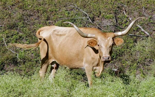
Texas Longhorn
The Texas Longhorn is a breed of cattle which gets its name from its very "long" horns: they can measure up to 7 feet (2.1 m) from tip to tip.
They originated from the cows and bulls brought from Spain to the New World shortly after the discovery and conquest of the Americas in the early 1500s. In America, they were introduced into California, Florida (a Spanish Colony until purchased by the U.S. government) and Mexico.
The Mexican cattle roamed into the territories later incorporated to the U.S.: Texas, Arizona and New Mexico.
They have a wide range of colors, from black to white, but the predominant tones are dark red and white or combinations of both. The horns tend to have an upward turn at their tips and may have several "twists".
Sturdy and well adapted to the dry conditions of the arid Iberian Peninsula, they survived well on the open Texas ranges, where water and food was scarce.
They were favored by the first Ranches, but later, they were replaced with other cattle breeds because their lean beef and lack of tallow was not appreciated in the late 1800s and early 1900s. Fortunately they were saved from a near extinction by the United States Forest Service in 1927.
The U.S.F.S. collected herds in Oklahoma and Texas keeping them in state parks, as reminders of the past.
They are now an interesting beef stock due to their adaptability and disease resistance as well as their leaner and therefore healthier beef.
The Landergins earned a fortune ranching in Kansas (Eureka and Coffeyville) by fattening cattle and shipping it back east. But as with all boom cycles, the bust cycle comes sooner or later, and it did in the closing years of the nineteenth century. The Landergins moved west and leased land in the Panhandle region of Texas.
In 1904 they leased part of the LS Ranch, in Oldham County and later bought it.
At the time the Choctaw, Oklahoma and Texas Railroad (which later became the Chicago Rock Island Railway) was extending its line west of Amarillo and the brothers opened a store in 1906 next to their ranch's headquarters. The railway built a siding there in 1908; that was the origin of the town of Landergin.
They also opened the first State Bank in nearby Vega in 1909.
The station and store were the beginning of a small village which in the mid 1920s was incorporated to the alignment of U.S. Route 66.
The brothers invested in land in other parts of Oldham and Deaf Smith Counties in Texas, and also in neighboring Arizona and New Mexico. They relocated in Amarillo (1912), where John passed away in 1923 (he was struck by a train) and Patrick in 1929. Their death led to the demise of their holdings, which were liquidated in the 1940s.
The town which carried their name languished for many years, overshadowed by Adrian to the West and Vega to the east. Its population peaked in the 1930s at 36 and after that dropped.
By the 1980s only two businesses were in operation and by the late 1990s only the Route 66 Antiques and the Neon Soda Saloon survived, ran by George and Melba Rook.
But time is inflexible and now only the buildings, shuttered and in disrepair, remain as reminders of where Landergin once stood.
Hotels: Where to Stay
There is no lodging in the Ghost Town; the closest town with hotels is Vega, alternatively you can lodge in the next big town in Texas, Amarillo.
> > Book your Hotels in nearby Vega or in Amarillo
Find your Accommodation
The towns along Route 66 in Texas offer different lodging options. Check out some of the hotels and motels in the main towns below listed from east to west
In Texas Along Route 66

What is the Weather in Landergin?

Where is Landergin on U.S. Hwy. 66?
This area is dry but very sunny: rainfall averages 20 in per year (500 mm). Summer average high temperatures (June to end of September) are above 91°F (30°C) with average lows around 64°F (19°C). The winter has highs of about 50°F (10°C) average, with lows well below freezing: 25°F (-4°C).
It can Snow in Wildorado during late fall, winter and even late spring. But you will see the first snow after early December.
The higher altitude of the area causes greater snowfall; around 19” per year on average (with peaks over 40”); that is: 43 to 102 cm. The region around Landergin is also is among the windiest in the U.S.
Tornadoes, this is the western tip of "Tornado Alley" with very low probability of tornados (read more: Tornadoes on Route 66).
Landergin's Map of Route 66
We divided the course of the highway across Texas into two legs, from Texola in the east to Glenrio on the NM state line. The midpoint of Route 66 is located in Adrian TX:
>> See this Interactive Map of US66 in Landergin.
On our Route 66 Map of Texas we include all of the alignments of US 66 in Texas. And the towns on the highway.
The following map dates back to 1936, when the new Route 66 alignment had been paved, on the south side of the railroad (now the tracks have been lifted, and US 66 is buried beneath the lanes of the freeway). The original highway commissioned in 1926, ran on the north side of the tracks (red arrows), roughly 100 yards north of what is now I-40.
Texas State Highway Dept. Map from 1936
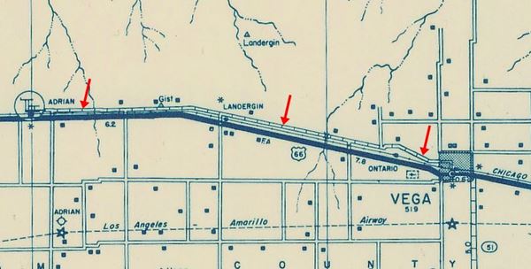
Alignment of Route 66 in this area
Landergin’s Route 66 Landmarks
A ghost town, the ruins of what was once a small rural town along US Hwy. 66.
Ghost Town Attractions
Landergin Ghost Town
Exit 28 I-40., Landergin, TX.
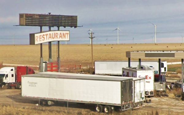
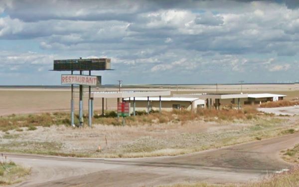
Now, nothing remains but empty, abandoned buildings on the north side of I-40s frontage Road, by Exit 28. It puts mortality, the transience of life and permanence of people and things in a clear perspective.
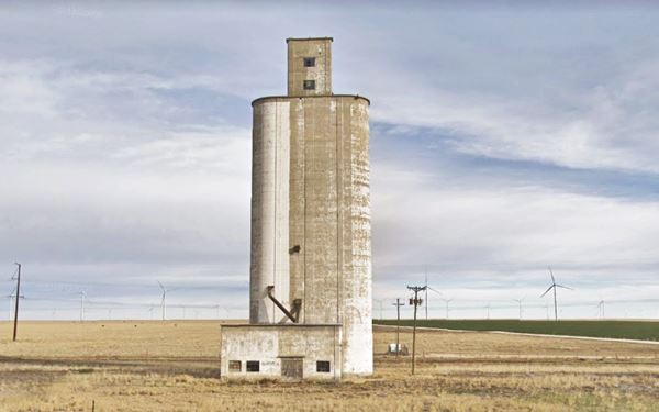
These silos are a legacy of the village's agricultural heritage. Next to it is the now empty truck stop:
Sponsored Content

>> Book your Hotel in Amarillo Texas

Credits
Banner image: Hackberry General Store, Hackberry, Arizona by Perla Eichenblat.
Survey of Route 66 through Texas Texas Historical Commission.
Route 66 maps Texas Historical Commission.

