Route 66 in western Texas
Index to this page
About Bushland, Texas
Facts, Trivia and useful information
Elevation: 3,825 ft. (1,166 m). Population: 3,305 (2025).
Time zone: Central (CST): UTC minus 6 hours. Summer (DST) CDT (UTC-5).
Bushland is located in the south of Potter County, in the central region of the Texas Panhandle, it is an unincorporated community that straddles I-40, 14 mi. west of Amarillo.
Bushland's History
The Panhandle region has been inhabited for over 10,000 years. The Clovis stone tools of Paleo-Indians were found nearby in Clovis New Mexico, and are among the oldest in the Americas.
The Spanish explored the region in 1541 but it remained under control of the Comanche and Kiowa Indians, who hunted buffalo on the plains. After Texas' independence and its inclusion in the United States, war between Indians and the U.S. led to the defeat of the former and their internment in reservations.
The plains opened up to settlers and the County of Bexar was organized in 1876. Shortly after, William Henry Bush visited the region scouting for suitable land for a ranch for his father-in-law, inventor of barbed wire, Joseph Glidden.
Glidden bought the land chosen by Bush and set up his Frying Pan Ranch in 1881.
The railway arrived (Fort Worth - Denver railway) in 1887 and that same year Potter County was formed.
William Henry Bush (1849 - 1931)
Born in Martinsburg New York, he worked his way from an apprentice to a partner in a wholesale hat company in Chicago. In 1877 he married the only daughter of Joseph F. Glidden the inventor of modern barbed wire.
Glidden commissioned him to go to the Panhandle to scout for land for a ranch to field test Glidden's barbed wire. Bush selected well watered ground at Tecovas Spring which Glidden and his partner H. B. Sanborn purchased as the basis for their Frying Pan Ranch. Bush was made a partner.
Bush continued in the hat business but was an active promoter of Amarillo, buying land in the new town.
Glidden transferred his ranch to Bush in 1898 at a time when Bush was lobbying for the Chicago, Rock Island and Gulf Railway to acquire the Choctaw, Oklahoma and Texas line, which took place in 1903, followed by tracks from Amarillo to Tucumcari, New Mexico. Bush gave the right of way through his ranch.
He donated land on this line for a station to ship out his Frying Pan produce. He lived in Amarillo till his death. Bush was a patron of the Art Institute of Chicago and the Amarillo Public Library. His gift of land in 1900 established the site of St. Anthony's Hospital. His heirs still own land in several Panhandle counties.
The town was dedicated on July 3, 1908 by Bush and his partner S. H. Smiser. Bush named the streets that run north to south after relatives and friends, for instance: Simmons and Robinson were his sisters' married names.
Settlers began to arrive and a post office opened in 1909. A school district was established. Bushland's First Baptist Church was organized in 1914 and still cares for the community's religious needs.
Population rose to 175 by 1940 and has more or less remained stable until this day.
Name changed from Bush to Bushland
The station was called Bush Stop but later switched to Bushland, apparently after W. H. Bush's wife persuaded the station master to repaint the station signs with the new name because the shabby town gave an unfavorable image of the family's name.

Where to Stay in Bushland
Neighboring Amarillo has a wide large variety of hotels and motels, and so does Vega, to the west.
>> Book your Hotel in Amarillo
Find your Accommodation
The towns along Route 66 in Texas offer different lodging options. Check out some of the hotels and motels in the main towns below listed from east to west
In Texas Along Route 66
>> There are RV campgrounds in neighboring Vega.
The weather in Bushland
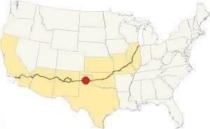
Map showing where Bushland is located on U.S. Hwy. 66
The average rainfall is 20 in. (500 mm); the Panhandle is a semi-arid region. Summer is hot, with average highs temperatures exceeding 90°F (30°C), with average lows of around 66°F (19°C).
The average high temperatures during winter are around 50°F (10°C) with lows averaging 24°F (-4°C).
It is very probable that you may encounter Snow during winter (first snowfall is usually during early December). Between 17 and 40 inches of snow may fall between September and May. (43 to 102 cm).
Tornados
The region around Amarillo is one of the windiest in the U.S., and also part of "Tornado Alley". Read more: Tornadoes on Route 66.
Map of Route 66 in Bushland
Route 66 itinerary across Texas
We divided the course of the highway across Texas into two legs, from Texola in the east to Glenrio on the NM state line. The midpoint of Route 66 is located in Adrian TX:
>> See this Interactive Map of US66 in Bushland.
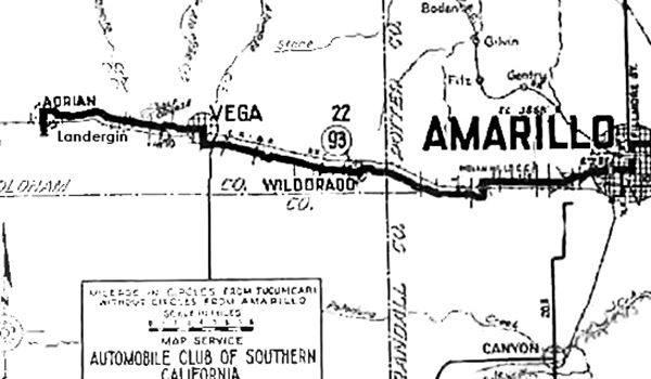
The map shown above predates Route 66 by six years, it was published in 1920 and shows the main road that would become Route 66 until the early 1930s.
Visit our webpage with the Route 66 Map of Texas it has the different alignments of US 66 across Texas with links to each of the towns along it.
Route 66 segments near Bushland
In the following webpages we describe each of the alignments near Bushland, in a dedicated webpage with maps, itineraries, and US66 attractions along the highway.
Alignment of Route 66
- Glenrio to Tucumcari Historic Route 66 (next)
- Amarillo to Glenrio Historic Route 66 (Bushland's)
Bushland’s Route 66 Landmarks
The classic sights in town!
Bushland is a small town located on US 66 (now I-40) with several historic sites close to it. None of its motels or gas stations have survived from Route 66 period in the town itself.
Jack DeVere Rittenhouse in his 1946 "A Guide Book to Highway 66" wrote:
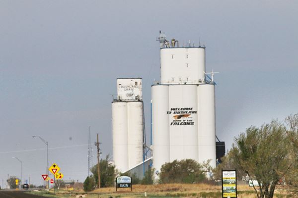
Bushland, this small hamlet has only a few homes and the ever-present grain elevators to serve surrounding farms. Rittenhouse (1946)
Driving out of Amarillo towards Bushland along the original Route 66 Indian Hill Rd. you will reach the site of a deadly US66 underpass.
The Deadly Underpass of US 66
Located 2.1 miles east of Bushland, at the intersection of Hill Dr. and Indian Hill Rd.
You can see it in the image (map published in 1936), on its left side next to Bushland.
This dangerous "S" shaped underpass was later replaced by a new one close to what is now Exit 62 of I-40. At the spot where West Amarillo Blvd. meets the freeway (map).
The old deadly underpass

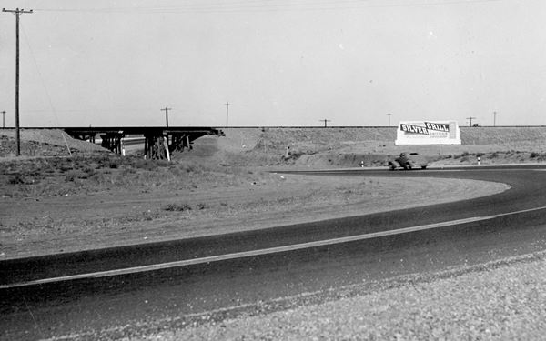
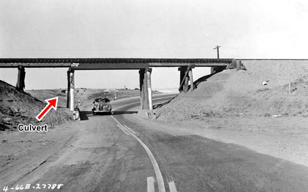
Deadly Underpass on 1940s US 66, Bushland. A. Whittall
The 1930s and 40s alignment of U.S. hwy 66 did not pass under the tracks near the Helium Plant as it did later. The road continued with a westerly direction for another 3.5 mi. following what now is known as Indian Hill Road.
This road ran along the side of the railway tracks (which have since been removed). When it reached what is now Hill Dr., it took a sharp entry and a sharp exit curve to pass under the tracks following an "S".
You can still see the original roadbed just before its intersection with Hill Drive. This is the old 1940s highway paving. You will find it on the left side of the road.
It seems that this part of Route 66 was the most dangerous of the whole highway. The unexpected "S curve" caught drivers unaware; speeding drivers crashed frequently.
Look towards the south at the intersection with Hill Dr. and you will spot the big chunks of cracked tar road surface curving towards the left between the old railway corridor (the tracks are long gone) and Indian Hill Rd.
The image shows (top) the "S" of the old road in Red, the arrow marks the surviving portion of US Highway 66, and the railway line - shown with the yellow line in the map (St. view). It also shows (bottom) a 1984 USGS map with contour lines, which explains why the underpass was located here: The drainage is towards the south (bottom) through a culvert on Indian Hill Rd. and under the tracks, which ran on an embankment at that point (brown dashed lines). It is clear that the railway's bridge over this natural drainage was selected for the old U.S. 66 underpass (Red "S" in the bottom part of the image). Modern I-40 is the double red line below the tracks.
The "Death Trap", as it was known, stood there until the early 1950s (a deadly accident was recorded there in 1951) when the road was shifted to the south side of the tracks and the underpass, with a less pronounced "S curve" was built at its current position closer to Amarillo.
The two photographs below show the underpass during the mid 1940s.
The culvert seen in the bottom image partially hidden by the column to the left of the car, is still visible in the satellite image, just before the crossing.
Old Gas Station
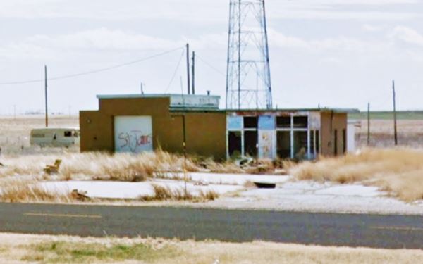
Drive west to Bushland pass by the grain elevators mentioned by Rittenhouse and head west, after 3 miles, at Adkisson Rd. on the south Frontage Road (map), is an old oblong box gas station in ruins.
It has no canopy. Its office with two restrooms, a single bay garge and two pump islands are standing, abandoned.
This ends your tour of Bushland, head west to Wildorado
Sponsored Content

>> Book your Hotel in Amarillo Texas

Credits
Banner image: Hackberry General Store, Hackberry, Arizona by Perla Eichenblat.
Route 66 maps Texas Historical Commission.
Paul H. Carlson, 208. Empire Builder in the Texas Panhandle: William Henry Bush. Texas A&M University Press.
H. Allen Anderson, "Bushland, TX"

