
Ghost town on Route 66
The Royal Inn and Café Neon Signs

Index to this page
About Wildorado, Texas
Facts, Trivia and useful information
Elevation: 3,915 ft. (1,195 m). Population: est. 246 (2025).
Time zone: Central (CST): UTC minus 6 hours. Summer (DST) CDT (UTC-5).
Wildorado is located in the south of Oldham County, in the western region of the Texas Panhandle. The town straddles old Route 66 (now I-40), 23 mi. west of Amarillo.
The name: Wildorado
The town's name comes from Wildorado Creek, whose sources are just 1.5 mi north of the town, the name is of uncertain origin and perhaps combines the words "wild" and "Eldorado", a mythical lost city with abundant gold treasures (from the Spanish words: El Dorado: "The Golden one").
Wildorado's History

Wildorado depot and grain elevator c.1910. Source
Human beings have inhabited the Panhandle for a long time; remains of Paleo-Indian stone tools 10,000 years old have been recovered nearby, in Clovis New Mexico.
The Spanish Conquistadors explored the region in 1541 seeking for the mythical town of «Eldorado», but only found Indians and a dry flat territory.
The Comanche and Kiowa Indians ruled the land and hunted buffalo on the plains. Only after Texas' independence and its inclusion in the United States did white settlers reach this region.
After a war (1874 - 76) the U.S. defeated the Indians and placed them in reservations. Tascosa, on the Canadian River became county seat of Oldham County (1880) and the Fort Worth - Denver railway reached it in 1887.

Bank robbed eight times. Fulton History.com
The old cattle trail that linked Tascosa in the north with Canyon City in the SE had a campsite at what is now Wildorado. Before 1900 Eugene Binford and John Goodman had settled there and Goodman opened a post office in 1904.
The Chicago, Rock Island and Gulf Railway chose the spot as a site for a station on its line west from Amarillo, and built it there in 1908. By that time the Goodman's Wildorado State Bank had opened.
Population reached 100 in 1915 and the town boasted two churches and a newspaper, the Wildorado Progress, founded in 1909.
The late 1920s were violent and the local State Bank was robbed eight times between 1925 and 1928.
It was the days that U.S. Route 66 was created (1926) and a growing number of travelers crossed the country passing through Wildorado. Travel boosted the economy during the grim period of the Dustbowl and Depression in the 1930s, during which population dropped to 57. The 1940s brought growth and population increased to 125.
When I-40 passed through the town, the south side of Old Route 66 was demolished to make space for the new highway.
Irrigation for the farms and new environmentally friendly energy sources ensure the town's economic future.

Wildorado Wind Ranch
The Wildorado Wind Ranch is a renewable-energy project to generate 160-megawatt from the Panhandle winds. It has seventy wind turbines with an output of 2.3 MW and over 30 miles of underground power lines.
Nancy Jean Binford (1921 - 1998), Cowgirl
Born in Amarillo but lived most of her life on the 10,000 acre Binford Ranch in Wildorado. She graduated at the Texas Tech University at Lubbock.
She was a sponsored "Sweetheart" in rodeos for the Range Riders of Amarillo and a member of the American Quarter Horse Association. She was also a charter member of the Girls' Rodeo Association which she helped found in 1948 and sponsored the first all-girl rodeo in Amarillo, the "Tri-State All Girl Rodeo".
Ms. Binford organized and produced all-girl shows in the South West, and also won the world's championship in cutting horse competition and in roping in 1950. She was inducted in the Cowgirl Hall of Fame in 1979.

Where to Stay in town: Lodging
You can lodge at the Royal Inn motel in Wildorado. Also in neighboring Vega or Amarillo
> > Book your Hotels in nearby Vega or Amarillo
More lodging Near Wildorado on Route 66
The towns along Route 66 in Texas offer different lodging options. Check out some of the hotels and motels in the main towns below listed from east to west
In Texas Along Route 66
>> There are RV campgrounds in Vega and Amarillo.
How is the Weather in Wildorado?

Map showing where Wildorado is located on U.S. Hwy. 66
The average rainfall is about 20 inches (500 mm) making the Texas Panhandle a semi-arid region. Summer is hot, with average highs above 90°F (30°C) and with average lows of 65°F (19°C). Winter are quite sunny and the maximum temperatures average 50°F (10°C) with average minimum temperatures of 25°F (-4°C).
It does Snow in Wildorado during winter, starting early December but you can encounter snow between September and May. On average, each year sees 17 inches of snow (with peaks of 40”), that is, from 43 to 102 cm. The region around Wildorado is among the windiest in the U.S. and that is why it has been chosen for wind farms.
Tornadoes, this is Tornado Alley, read more: Tornadoes on Route 66.
Map of Route 66 in Wildorado
We divided the course of the highway across Texas into two legs, from Texola in the east to Glenrio on the NM state line. The midpoint of Route 66 is located in Adrian TX:
>> See this Interactive Map of US66 in Wildorado.
See this Map of Route 66 in Wildorado.
Check out our Route 66 Map of Texas. The map has all of the alignments of US 66 in the state, and also links to each of the towns along it.

A 1936 map of Wildorado. Route 66 is the thick blue line.
In the map below, Route 66 in Glenrio appears as an unpaved "graded road, drained and maintained. Usually bad during wet weather"
Below is a highway from 1956. You can see that from Amarillo almost to Wildorado, US 66 was a "Super-highway 4 or more lanes".
Route 66 (Shell) Map at Glenrio in 1956.

Alignment of Route 66
These are the sections of Route 66 in Wildorado. We describe each of them in a dedicated webpage with maps, itineraries and attractions along the way.
Wildorado’s Route 66 Landmarks
Wildorado is such a small town that it never incorporated. I-40 did not even bypass it. The Interstate cut right through the town, demolishing buildings on its south frontage road.
On the north side of the freeway there is an old gas station, the site of the old Railway depot, and plenty of grain elevators. On the southern side of the freeway there are old service stations and the neon signs of the fire ravaged Royal Inn Motel.
In his "A Guide Book to Highway 66" published in 1946, Jack DeVere Rittenhouse tells us about Wildorado during Route 66's golden age:
Pop. 101; Wildorado garage; gas; cafe; grocery; no tourist accommodations.) Like Bushland, this small hamlet has only a few homes Jack Rittenhouse (1946)
This is the map of our city tour (2.5 mi tour). We start on the NE side of town.
Ricky's Towing Gas Station
To your right is a former gas station, now named Ricky's Towing (an Amarillo business). Next to it is a wood faced building, constructed to look like an "old wild west" building. It was "Fort Wildorado Trading Post", later a pawn shop. The gas station's office also was a restaurant.
Ricky's Towing, a vintage Gas station.


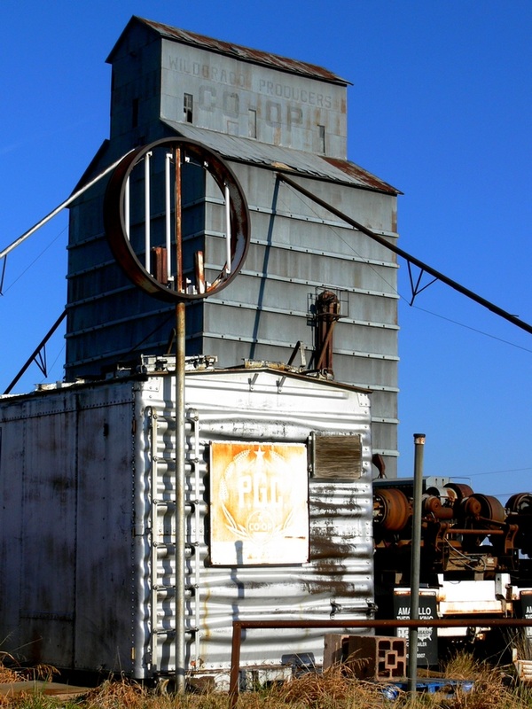
Grain Elevator in Wildorado. Source. Click on image for St. view
Grain Elevators
As you drive west along the North Frontage Road, you run parallel to the former railway tracks (roughly 50 yards to your right).
Ahead, to your right, loom all types of silos and grain elevators. This is an agricultural region. These silos store the produce.
Wildorado is located in Oldham County, which has around 160 farms with an average size of around 5,220 acres. They produce on average $710,000 each year of agricultural producs.
The main crops are wheat for grain, and sorghum for grain.
At the western tip of town, turn around and head back to the underpass on FM-809, cross to the south side of I-40 and turn right. Drive west till you reach the old Motel.
Royal Inn Motel
It is located on the south side of the South Frontage road of I-40. Its neon signs of the motel and cafe, stand out. The motel's south wing was gutted by a fire in December 2015.
Originally named "Texan Motel" it formed a complex with "Jesse's Cafe", the postcard of both businesses tells us that it had "Refrigerated Air - TV - Home made pies".


Jesse's Café nowadays
The St. view (click image above) shows the burned wing of the motel. The Cafe is still the same, unchanged.
Another Gas Station
Next to it (east) is a 1970s gas station with two pump islands under a flat detached canopy. It had a two bay garage. (St. view).
Former Chevron station
Ahead is another gas station with a gable roof, also from the 1970. Flat canopy supported by four steel pillars over the two pump islands. And a tripod pylon that once held the station's sign.

Old Conoco station
It is followed by a former Conoco with a semi-detached canopy typical of the Conoco 1950-1970 gas stations. There is horizontal banding around the roofline of the office and service bays. The sign over the two pump islands says "Garage".

Now razed Gull Wing Phillips 66

Gull Wing Phillips Torn down
There was a Phillips 66 Gull Wing station just ahead, but it was torn down. St. view of the station before it was razed.
Ahead, after the underpass is a timber structure windmill (St. view), and on the eastern tip of town, another possible vintage gas station. The building has two garages (former bays?) and what seems to be a room under the former canopy (St. view).
This ends your city tour of Wildorado.
Sponsored Content
>> Book your Hotel in Amarillo Texas
Credits
Banner image: Hackberry General Store, Hackberry, Arizona by Perla Eichenblat
Amarillo Globe News, obituaries, July 29, 1998
H. Allen Anderson, "Wildorado, TX", Uploaded on June 15, 2010. Handbook of Texas Online, Published by the Texas State Historical Association.
The Route 66 through Texas Historic Report - Glenrio, Texas Historical Commission.
Jack DeVere Rittenhouse, (1946). A Guide Book to Highway 66.