Solar Capital of Texas
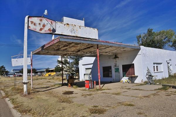
Texaco on Route 66 in Vega TX
Index to this page
About Vega, Texas
Vega: Facts, Trivia and useful information
Elevation: 4,029 ft. (1,229 m). Population: 890 (2025).
Time zone: Central (CST): UTC minus 6 hours. Summer (DST) CDT (UTC-5).
Vega is located in the south of Oldham County, and is the County seat. It is set in the western region of the Texas Panhandle on the water divide between the Canadian River to the north and the Palo Duro Creek to the south.
It is located at the junction of Interstate 40 (Old Route 66) and U.S. 385, 35 mi west of Amarillo.
Vega's History
Human beings have inhabited the Panhandle for a long time; remains of Paleo-Indian stone tools 10,000 years old have been recovered at nearby Clovis in New Mexico.
Shortly after the conquest of Mexico, the Spanish Conquistadors roamed the region in 1541 and left it to the Comanche and Kiowa Indians, who ruled the land and hunted buffalo unhindered till the mid-1850s.
White settlers began occupying the region after Texas' independence and incorporation to the United States. This led to problems with the natives and after a war (1874 - 76) they were defeated and enclosed in reservations.
Tascosa, on the Canadian River became county seat of Oldham County (1880) and was linked by rail with Fort Worth and Denver in 1887.
N. J. Whitfield purchased the land that would become Vega in 1899. Besides selling land to other homesteaders he also sold a strip of land, in 1903, to the Choctaw, Oklahoma and Texas Railroad (it later became the Chicago Rock Island Railway) as right of way for their tracks. The town was surveyed that same year by Miller and Trigg; Miller opened quickly opened the town's first store. In 1907, the Landergin brothers purchased a ranch in the area and attracted more settlers to the new town (they founded what is now the ghost town of Landergin); they also opened a bank in Vega in 1908.
The railroad was finished in 1909 bringing prosperity and more business. It soon overshadowed the county seat of Tascosa and became the new seat in 1915.
It was incorporated in 1927 and faced a fire which burned several buildings down in 1931. This led to the organization of a city-wide water system.
U.S. highway 66 was created in 1926 and passed through Vega, bringing visitors and more business to town: motels, food outlets and gas stations sprouted and many still survive to this day as memories of bygone days.

Hotels in Vega
You can lodge in Vega.
> > Book your Hotels in Vega
More lodging Near Vega along Route 66
The towns along Route 66 in Texas offer different lodging options. Check out some of the hotels and motels in the main towns below listed from east to west
In Texas Along Route 66
>> There are RV campgrounds in Vega.
The weather in Vega
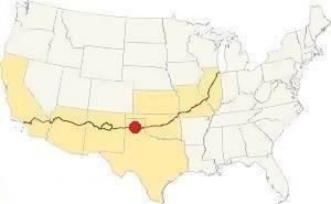
Map showing where Vega is located on U.S. Hwy. 66
The region surrounding Vega is dry, windy and very sunny: rainfall averages about 20 in. per year (500 mm).
Average Temperatures: during Summer highs are above 90°F (30°C) and lows are 64°F (19°C). Winter lows are 24°F (minus 4°C) with highs of 50°F (10°C).
It snows in winter around Vega, on average, after the first week of December, but you can expect snow at any time after mid September until mid May. Some 20 inches of snow (50 cm) fall each year, reaching 40” (1 meter) on exceptional winters.
The region around Vega is also is among the windiest in the U.S.
Tornadoes, Vega is on the western tip of Tornado Alley; read more: Tornadoes on Route 66.
Map of Route 66 in Vega
We divided the course of the highway across Texas into two legs, from Texola in the east to Glenrio on the NM state line. The midpoint of Route 66 is located in Adrian TX:
>> See this Interactive Map of US66 in Vega.
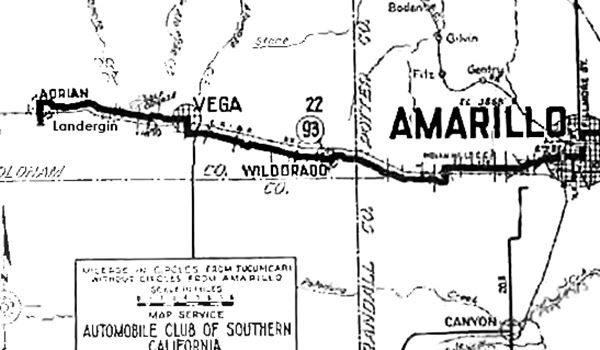
The map above was published in 1920 and predates Route 66. It shows what would later become the first alignment of Route 66 in the 1920s and early 1930s. The Mother Road entred Vega following a now vanished course that linked the N. Frontage Rd. at Exit 73 with Culberson St. Then, at S. Main St, it took a right heading due north (along what is now US 385).
The highway passed through the downtown area of Vega, and at the Courthouse by W. Main St. it took a left and continued westwards beyond the current end of West Main St., entering the plains and running with an alignment that is more or less parallel to I-40s North frontage road, but about 100 yards to its right, all the way to Adrian.
See this Map with directions.
In 1936 it was realigned along what is now I-40 Business W - US 66, and west along Vega Blvd. after passing Main St. See this map with directions.
Check out our Route 66 Map of Texas which has all of the alignments of US 66 in the state, and also links to each of the towns along it.
Route 66 segments near Vega
These are the sections of Route 66 close to Vega. We describe each of them in a dedicated webpage with maps, itineraries, and US66 attractions along the highway.
Alignment of Route 66
Vega’s Route 66 Landmarks
Touring US 66 through Vega
Two Old Gas Stations
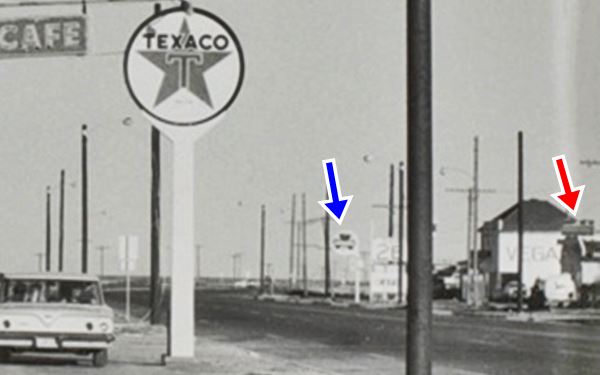
We will begin our tour on the eastern side of Vega. As you drive into the town, on the SE corner of 4th St. and Route 66 you will see the ruins of a gas station. And ahead, on the next block, another former gas station. Both can be seen in the following photograph taken in 1962 (see arrows). The building between them, with the word "VEGA" on it, has been razed.
Detail from Ed Ruscha's 1962 Texaco photo
Station #1
You can see it marked with the blue arrow in the photo taken in 1962 by Ed Ruscha.
At that time it was a Shamrock Oil and Gas station. Its logo was round and had a green three-leaf clover with the word "Shamrock" in the center.
Shamrock owned its own refinery and a chain of service stations in the Southwest, and in 2001 it was acquired by Valero.
Station #2
The image shows the former gas station, it is the one marked with the red arrow in Ed Ruscha's photo. It has the same parapet at the top of the facade. You can still see the concrete pumps island.
Old Vega Texaco Station
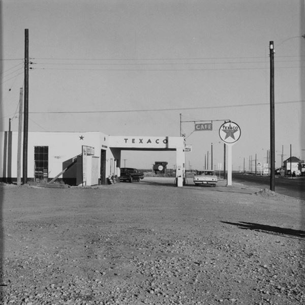
Continue west. To your right is an old Texaco, not as famous as the Magnolia station on Main Street, this old Texaco is in pretty good shape. You can still identify its canopy, pump islands and signage. It is pictured at the top of the page. It was photographed in 1962 by Edward Joseph Ruscha, an American artist who travelled along Route 66 many times from California to visit his family in Oklahoma. His first photobook titled "Twentysix Gasoline Stations" published in 1963 is the result of one of those trips. Below is his take of the Texaco in Vega.
Texaco on Route 66 by Edward Ruscha, 1962
Bonanza Motel
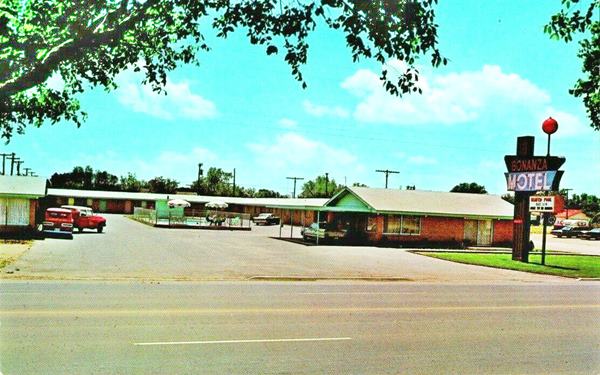
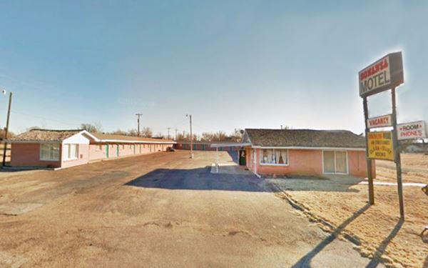
607 Vega Blvd., on the south side of the road, to your left. This motel is a classic motel of the 1950s, with the typical U-shaped layout found in most US 66 motels.
Below is a Then-and-Now photo sequence. The old sign, and the pool have gone, but the building is still there, and operating as a motel.
The postcard tells us it had "New 24 Deluxe units - large tile baths - Refrigerated air - Free TV and Radio - Wall to Wall carpets - Heated pool..." it was owned by Mr. and Mrs. E. C. Dodgin.
Bonanza Motel in the early 1960s
Hill's Café
The building is still standing and the neon sign of the "Vega Prairie Hills" Cafe with the letters C-A-F-E inside white diamonds, has survived until this day, but relocated a few blocks further west.
The Cafe was owned by the Floyd's (Loudine and Harvey) in the early 1960s. Notice how one sign spells "Hill's" and the other "Hills".
Hill's Café nowadays, click image for St. view
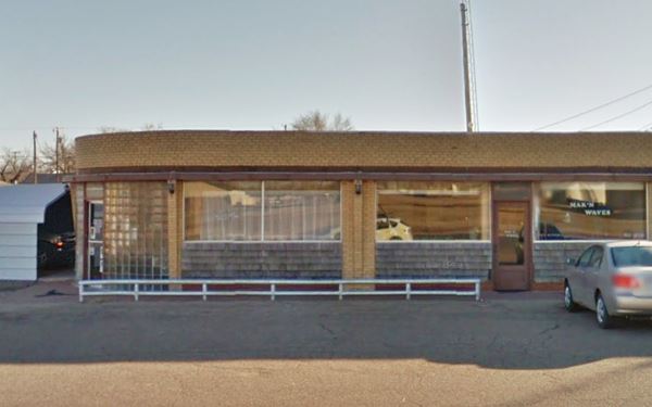
In the following postcard from the early 1960s, you can see the sand colored bricks and the glass-brick curved corner of the building.
Hill's Café in a vintage postcard.
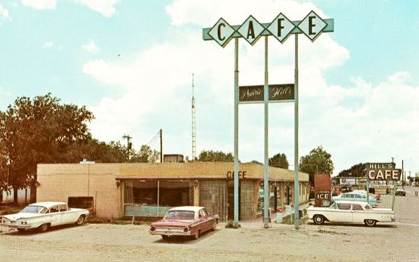
Notice the two neon signs: the low one, to the right, a classic, that has vanished; and the tall one with three supporting steel tubes which has survived and can still be seen further down the road, at "Hickory Cafe".

1950s picture Phillips 66. Source
Phillips 66 station
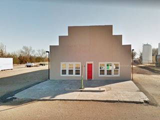
Next to it, to your left is a building that used to be a Phillips 66 gas station. The photo shows the western wing of Hill's Cafe (red arrow) and the gas station (Black arrows). You can see its present appearance in this 2008 St. view before the front room was added.
The box shaped building with two garage bays to the east, and the office to the west is still standing.
Two blocks ahead, at Main Street, turn right following the original 1926 alignment of Route 66. Two blocks to the north, after crossing the now lifted railroad, to your left is an old hardware store.

1930s picture Roark Hardware Store. Source
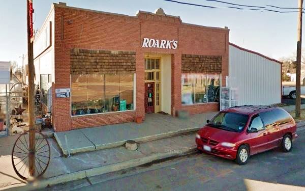
Roark Implement & Hardware Store
214 South Main St.
After crossing Coke St. you will see the brick building on the right side of the road. It is the oldest hardware store on US Route 66, and it still in operation.
The black and white photograph shows it in the 1930s, the caption reads "Lone Star Hardware Co. Vega, Texas", it hasn't changed since then.
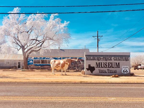
The Milburn - Price Culture Museum
Next door is the Museum. Drop by (it has a great mural as a bonus) and collections about the culture and history of Oldham County and the surrounding area.
Magnolia Service Station
Across the street from the hardware store and the museum, it is on the SE corner of former US 66 (N main St.) and Coke St.
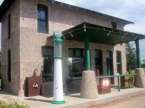
The second service station to be built in Vega was the Magnolia Service Station, in 1924. It had two stories, and the operator lived on the upper floor. The ground floor hosted a barber shop.
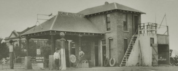
In the image above you can see the Court House to the left.
In the 1970s, after serving gasoline for decades, when I-40 bypassed the town, the service station closed. Recovery and restoration began in 2001 when the City of Vega applied to the National Park Service Route 66 Corridor Preservation Program for a cost- share grant.
The rehabilitated building was dedicated in 2004 and is now a visitor center and displays photographs and vintage artifacts for visitors to enjoy.
Old Court House
On the NE corner of US 385 (N main St.) and Coke St.

Vega Court House Built 1915 Keith Vincent
The original Oldham County seat was located in Tascosa since 1880, but as Vega grew in importance, Tascosa declined. In 1915 after a special election, the local citizens chose Vega as the new County seat. The courthouse was planned and construction began immediately, it was designed by architect O.G. Rouquemore in Classical Revival style.
The original hip-roof was removed in the late 1960s. The building is still there.
Route 66 shield, End Sign and Roadside Attraction Marker
At the next corner, there is a Historic Route 66 sign, and a painted US 66 shield. Follow its arrow, turn left along West Main St. and two blocks west you will find more attractions.

Original alignment End sign. Source
St. view of the sign.
Here, to your right, on the NW corner, is the "Old Route 66 END" sign of the 1926-36 Route 66 alignment which now is a dead end just ahead, but in those days it ran all the way to Adrian parallel to its current alignment, but on the north side of the tracks of the railroad, which has since been closed and the tracks lifted.
Next to the sign by dotties museum left side on the corner is the Roadside Attraction Marker of Dot's Mini Museum.
Dot's Mini Museum
105 N 12th St., Vega. It was ran by the late Dot Levitt. She came to Vega in the 1940s with her husband Harold and they ran a store (Vega Zero Lockers) which offered freezing storage for the locals.
Her "Museum" exhibits plenty of memorabilia she collected during her long life in Texas, spanning cowboy articles, an Avon perfume bottle collection and Route 66 items.
Dot's daughter Betty Carpenter has kept the museum open.
Turn around and retrace your steps to South Main St. and Route 66. Turn right to head west.
Vega Motel
Ahead to your left, at 1005 W. Vega Blvd., Vega, TX.
Listed in the National Register of Historic Places
A classic hotel of the heyday years of Route 66 in the late 1940s.
It began as the Vega Court when it was built by Ervin Pancoast in 1947. Those were the boom days of Route 66: the U.S. economy was booming, people were relaxed and enjoying their free time and prosperity after the grim days of the Great Depression and World War II.
The historic and classic Vega Motel, a vintage lodging on Route 66.
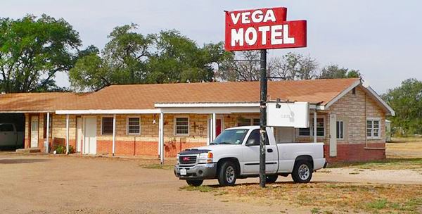
It was built with two wings, one on the west, the other on the south. It had 12 units. The office and living quarters were located in a small house in the central courtyard.
Pancoast married in 1948 and lived on the premises, operating his motel.
The "U" shaped court was finished when the east wing was added in 1953. The motel now had 20 units, of which 8 had built-in garages as well as bathrooms (some even had kitchenettes).
Business was good and in 1964 the motel was revamped with Perma-Stone.
But changes were brewing: air travel and the Interstate highway system (I-40 in Vega was finished in the early 1970s) which bypassed the small towns led to a drop in road travel. The Pancoast sold the motel in 1976.
Vintage postcard of the Vega Motel
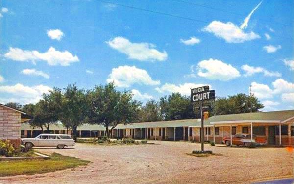
The postcard shown above has the following description on its back: VEGA COURT, On highways 66 & Interstate 40, E & W U.S. 385, N & S. 20 Rooms-Panel Ray Heat - Completely Air Conditioned. Vega's Newest and Finest. VEGA, TEXAS. Owned and Operated by Mr. and Mrs. E. M. Pancoast.
It is a rare instance of a surviving motel, in pristine conditions, an example of the old motor court days of US 66.
It was listed in the National Register of Historic Places in 2006.
Motor Courts
The first accommodations along America's highways were rather rudimentary: the auto camp and the tourist home. The auto camp was an area with roped off spaces for overnight camping. Fuel, water, showers and toilets were provided by the Camp supervisors.
They were replaced by the tourist homes, which offered indoor lodging, convenient when the weather was nasty.
The homes evolved into the cabin camp or cottages, which were huts or cabins with basic services.
World War II and its rationing led to more practical building systems and this to the motor courts or motels, where the cabins were unified under a single roof, with shared walls and simpler drainage, power and water systems.
Many motor courts offered souvenir shops, swimming pools, air conditioning and even adjoining diners. By 1948, there were 30,000 motor courts along American highways.
Hickory Inn Café
Facing the motel, on the north side of the street (1004 Vega Blvd., Route 66) is this classic cafe that has preserved the old sign of Hill's Cafe, pictured below.

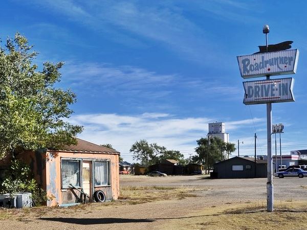
Roadrunner Drive-in
Ahead, also to your right is the neon sign of the Roadrunner Drive-In. All that remains of the place.
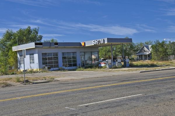
Former Shell Station
Across the street, to your left is a former Shell gas station.

Rooster Restaurant, Source
Roosters Mexican Restaurant
Head west, and don't miss the Roosters Mexican Restaurant (second block, to your right) which originally opened in 1945 as Carl's Service Station & Café.
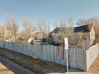
Continue along US66 and ahead after passing the Walnut RV park, to your left is another abandoned gas station.
West Vega gas station
The oblong box building has a two bay garage, an office, and a cafe on its western tip. No canopy has survived, but the concrete pump island has survived. Abandoned and falling apart it was Orville Groneman Service station, built in 1945.
See its St. view.
Sands Motel
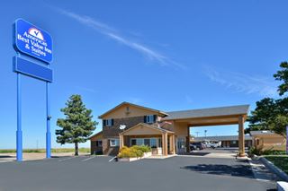
Ahead (1800 Vega Blvd.) to your right is what once was the Sands Motel. Its postcard tells us: "Air Conditioned... Central Heating... Excellent Restaurant Adjoining... Member Diners Club". It is still open and operating as a motel, but now is the Americas Best Value Inn and Suites (book your room).
Below is a "Then and Now" sequence. The basic "U-shaped" layout has not changed, it has kept its gabled roofs, but its lovely 60's neon sign has gone:

Sands Motel, Vega, vintage postcard
Route 66 shields on the road
Ahead, just west of the motel are two US66 shields painted on the roadbed see map.
Ontario
Ghost Town
On US 66, 2 mi west of Vega are the remains of a ghost town founded in 1908 by the T. Carrabine & Co., on the Chicago and Rock Island Railway. It had a post office, hotel, some homes and a general store. But it lacked a good source of water and this doomed the town: residents and business moved to neighboring Vega. The hotel burned down and the post office closed in 1912.
The foundations can still be seen in the grass.
Sponsored Content

>> Book your Hotel in Amarillo Texas

Credits
Banner image: Hackberry General Store, Hackberry, Arizona by Perla Eichenblat
Vega Motel Discover Our Shared Heritage Travel Itinerary Route 66, National Park Service.
H. Allen Anderson, Vega, TX and Ontario, TX. Handbook of Texas Online, Published by the Texas State Historical Association.
Jack DeVere Rittenhouse, (1946). A Guide Book to Highway 66.


