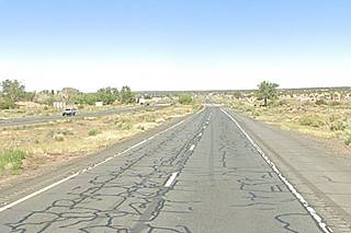
Route 66 in Houck AZ
Index to this page
About Houck, Arizona
Facts, Trivia and useful information
Elevation 5,935 ft (1.819 m), population n⁄a (2025).
Time zone: Mountain (MST): UTC minus 7 hours. Summer (DST) no DST⁄ PDT (UTC-7).
Houck is a small village in Apache county, only 11 miles from the New Mexico State Line.
History
The Ancestral Puebloans, referred to nowadays as Anasazi, lived on the Colorado Plateau in an area bound by southern Nevada, Utah, Colorado on the north, and on the south, the Colorado and Little Colorado, rivers in Arizona and the Western Rio Puerco in NM. To the east, the Rio Grande River in New Mexico. They flourished as farmers between 700 and 1150 A.D., but drought and war forced them to the southest, into New Mexico, where the historic pueblos were contacted by the Spanish in the mid 1500s.
Houck lies on the southern edge of the Anasazi territory. To the south lay the land of the Mogollón, and west around Flagstaff, the Sinagua people.
The Navajo people were hunter gatherers who learned some farming abilities from the Pueblo people and later adopted goat and sheep herding when the Spaniards introduced these animals into New Mexico in the 1600s.
The Discovery of the Grand Canyon
Francisco Vázques de Coronado sent a party of twelve men under Garcia Lopez de Cardenas in 1540 to find out about a great river ("Tizá"- Spanish for Firebrand River) that ran to the west of Zuni Pueblo. They reached the village of Tuzan, in the land of the Hopi, probably modern Oraibi. From there they marched west to reach the south rim of the Grand Canyon and were the first Europeans to see the Grand Canyon and the Colorado River in Arizona.
Their trek from Zuni to Tuzan surely took them across what is now the alignment of Route 66 near Houck
They are the Diné (or "People"), and originated (like the Apache) from the Athabaskan people of Northwestern Canada and migrated to the American Southwest ca. 1400 A.D. The word "Navajo" derives from the Spanish name for them: "Apachu de Nabajo" (Apache of Nabajo) when they encountered them in 1620 north of Santa Fe.
The Navajo raids on the villages in Colonial New Mexico led to Spanish military campaigns against them. This warfare continued until the U.S. incorporated the territories after defeating Mexico in the 1846-48 Mexican-American War.
The U.S. decided to pacify the region and established a fort in what is now Arizona (at that time AZ was still a part of New Mexico), in Navajo territory: Fort Defiance.
Fort Defiance was established by Col. Edwin V. Sumner in 1851 as a military outpost in the Navajo territory. It was the first military post in what is now Arizona (in those days it was New Mexico). The site was chosen because it had very good grazing land around it.
The fort was in fact a "Defiance" to the war-like Navajo who were not allowed to use the pastures. They resisted and attacked the fort in 1856 and 1860. In 1861 the American Civil War broke out and the fort was abandoned as the Army retreated to New Mexico to face the Confederate threat.
Trivia
Apache County has the most land designated as Indian reservation of any county in the United States (68.34% of its area). Neighboring Navajo County is in third place.
This emboldened the Indians who intensified their raids on the New Mexican settlements. The new Commander in New Mexico, Brig. Gen. James Carleton clamped down on the Navajo and conducted an attrition war from the "Old" Fort Wingate near Grants (1862).
The natives finally surrendered and were forced to march (the Long Walk) under dreadful conditions for 450 miles (720 km) to a camp near Fort Sumner in NM. The dreadful conditons of this internment place led to Carleton's replacement and the Navajo Treaty of 1868 allowed the Indians to return to their homes. The Navajo Reservation was created and Fort Defiance was reestablished as an Indian agency.
Now it is a village in the Navajo Nation in Arizona, 33 miles north of Houck. (Map with Fort Defiance's location).
Apache County was created in 1879 and in 1895 Navajo county was split from it western part.
The Atlantic & Pacific Railroad (later the Atchison Topeka and Santa Fe RR) extended their tracks into the area in the early 1880s, along the Rio Puerco River, and this brought in more settlers.
The Name: Houck
James D. Houck owned a trading post here between 1877 and 1885, he also bred sheep. He later was a member of the State legislature.
The surname "Houck" comes from Middle Dutch: "houck" a kind of sea fish and also "buck". It is a variant of Hoek.
The Navajo called the place "Ma-it-go" meaning "coyote water". Houck's first name was "Houcks Tank" after the water tank belonging to Houck. The post office opened in 1884 as "Houcks Tank", changed to "Houck" in 1895, then it closed for decades until it reopened again in 1930, as Houck.
In 1926 Route 66 was aligned through the area following the National Old Trails Highway south of Houck. Although it was included in the 1930-60s Route 66, Houck already appeared in the Rand McNally 1927 map of Route 66, as being 12 miles west of Lupton, Arizona on an unpaved but "graded road".
Route 66 was later replaced by I-40 in the 1960s.

Where to Stay: Your hotel in Houck
There is lodging along Route 66 very close to Houck:
>> Book your Hotels in Chambers or in Holbrook
More Accommodation near Houck on Route 66
There are plenty of lodging options in the cities and towns along Route 66 east and west of Houck; click on the links below to find your accommodation in these towns, listed from east to west:
Eastwards
In Arizona Along Route 66
Westwards
You are so close to Las Vegas and the Grand Canyon!
>> There are RV Campgrounds nearby in Holbrook AZ and in Gallup NM
Weather in Houck
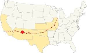
Location of Houck on Route 66
Houck has a semi-arid climate with hot summers and cold winters. Throughout the year, the day-to-night temperature swing is considerable due to the dry air and altitude. Summer nights are cool, but winter nights are very cold.
The average high temperature in summer (July) is 95°F (35°C). The average summer low is 59°F (15°C). The winter (Jan) has an average high of 50°F (10°C); with an average low of 21.9°F, below freezing (-6.1°C).
Rainfall is scarce: only 9.5 inches per year (241 mm), and most of it falls during the Summer Monsoon period between July and October (5 in, 127 mm). There are only 50 days with precipitation every year.
Snow is quite light, only 6.5 in. per year (16.5 cm), and it falls between October and April.
Tornado risk
There is virtually no tornado risk in Houck: Apache County has no Tornado watches. The area west of this point has no tornado events at all.
Tornado Risk: read more about Tornado Risk along Route66.
Map of Route 66 in Houck, AZ
Read the Detailed Description of this segment (Lupton to Winslow). Below is the interactive map:
>> Custom map of Route 66 in Houck

Lupton to Houck, detail of 1937 map. Source
Click on image to enlarge
The National Old Trails highway that served as Route 66's first alignment in 1926 ran further south, on the south side of the Puerco River from Allentown to Sanders. By 1930 it was marked for paving and it required improvement (the two bridges on this alignment had wooden decks and wore out quickly), also, a straighter and shorter route was desireable. So the Arizona Highway Department chose a route along the north side of the railroad, west from Allentown linking it with Houck and Sanders It was built in 1929 and in 1930 it replaced the old segment, which is a now county road used by the Navajo reservation residents.
The segment from Allentown to Houck is now overlapped by the westbound lanes of I-40 built in the mid 1960s. However, some maps state that it runs along what is now the North Frontage Rd. into Houck we will follow this alignment; see the Map (1930-65) Allenton-Houck.
After driving through Houck, the 1930s Route 66 alignment continued as the north frontage Road and then departed from current I-40, running further north to cross Box Canyon Querino Canyon.
You can drive along it westwards as shown in this 1930 - 47 Houck - Querino Canyon - Cedar Point map. After Cedar Point it runs again along the current freeway into Sanders.
The Querino Canyon and the Box Canyon bridges were bypassed with the 2-lane upgrade of the highway that runs where the eastbound lanes of I-40 run. The original bridges on this alignment were also replaced in the late 1970s. West of the junction where Querino Rd. becomes the N. Frontage Rd., the original US 66 1930-47 roadbed is buried by the freeway (west of Sanders it also comprises the N.O.T. and 1926-65 US66). We marked this alignment with a purple line in our "missing segments" map.
Route 66 Alignment near Houck
With maps and full information of the old roadway.
- Winslow to Winona (next)
- Lupton to Winslow (Houck's)
- Albuquerque to Lupton (previous)
Houck, Arizona, its Sights and Attractions
Things to Do and Places to See
Historic Context
Jack ritten house in his 1946 classic Guidebook to Route 66, mentioned this town and neighboring Querino trading post as follows:
HOUCK . Two establishments here: the White Mountain Trading Post ( which includes a postoffice ) and a small curio shop. Gas and groceries here.... QUERINO. Another one-structure "town," consisting of the Querino Trading Post. Curios and gas. Rittenhouse (1946)
Regarding Hock, Rittenhouse pointed out that the local Navajos were lounging around at the trading post in Houck and drinking soda pop.
Nothing remains of the White Mountain Trading Post. The current Houck exit on I-40 only preserves a wacky fort built in the 1960s:
"Fourt Courage"
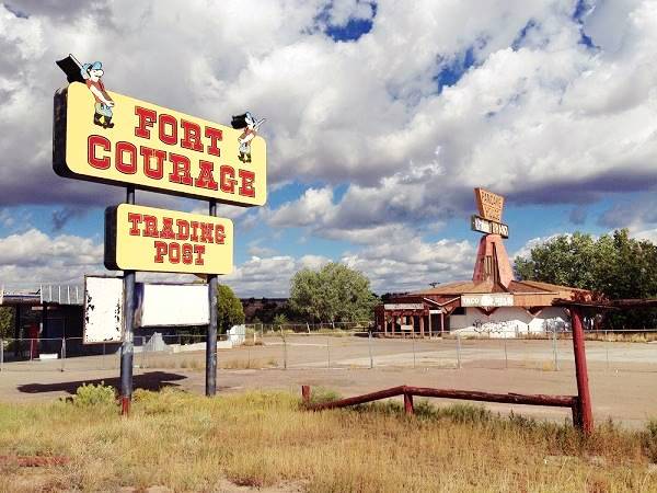
On the Northeast side of Exit 348 are the ruins of a replica Far West fort, the Frontier West shopping center, a gas station, a hogan and a restaurant. The sign by the fort announces in bold letters: "Fort Courage", and, the building itself is bound on its eastern side by a genuine-looking "Wild West" fort: this is indeed a replica of Fort Courage, but it is not a historic site; it was an imaginary place in a TV sitcom of the 1960s the series "F Troop" (street view).
F Troop
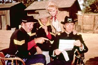
F Troop cast. Credits
F Troop was an American TV sitcom aired during two seasons (Sep. 1965 to Apr. 1967) with 65 episodes.
It was set in the Wild West of the 1860s and gave a comic and satirical account of the interactions between U.S. Army soldiers and Native Americans.
The bungling and inept commander, Wilton Parmenter is in charge of Fort Courage, Kansas, where Sgt. O'Rourke has dirty dealings with the Indians. See the Intro Video of the Series (External link).
The buildings
The images below depict the inexorable passage of time. Then in the 1960s and now: Fort Courage in Houck, AZ. Route 66
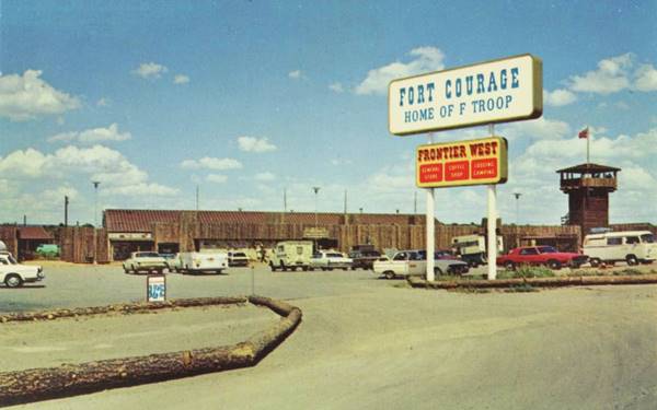
Houck, AZ. Source
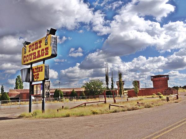
The postcard shown above, printed in the mid 1960s, says:
"FORT COURAGE Houck, Arizona Welcome to Fort Courage, 36 miles west of Gallup, New Mexico, on Interstate 40 - Highway 66 - at Houck, Arizona. Visit our Coffee Shop, Grocery Store, Gift Shop, and Trading Post. Large selection of authentic Indian jewelry, Navajo rugs, and all types of curios and souvenirs. Motel Units, Trailer Park, and Campground.
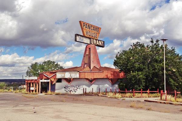
Pancake House
This odd shaped building dates back to 1967 when it was built as a Van de Kamp restaurant. Van de Kamp Holland Dutch Bakeries used a windmill as their tradmark and incorporated one to their outlets.
They modernized their design in the in the mid 1960s using a Googie style building designed by architects Harold Bissner and Harold Zook. Van de Kamp's Holland Dutch Bakeries was founded in 1915 in Los Angeles and it filed for bankruptcy in 1990. The brand is now owned by Pinnacle Foods Group.
Googie Architecture
Pronounced "gu:gi", it was a form of modern building design inspired in the Atomic and Space ages, with its geometric shapes, vast glass surfaces and symbolic motion designs (atoms, boomerangs, wing shapes, disks) with Space Age themes.
It appeared in California in the late 1940s and was popular until the late 1960s. Cafes, motels and service stations sported these modernistic designs. And Denny's is a good example of it.
The Houck building is the one of two surviving examples of these buildings, in this one the windmill is gone, but you can see it on an what isn now the Denny’s in Arcadia, California on Route 66. Pictured below
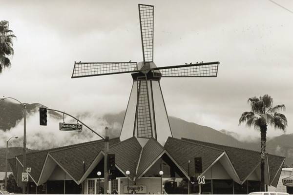
This building has 16 sides to it, to give it an almost circular shape, and also features a folded plate roof with 16 crests on it, and a pinnacle-steeple that supported the windmill's sail (or rotor).
This one was a pancake house and a taco outlet.
Route 66 becomes the freeway
The black and white image below show the original Route 66 in 1964, as the freeway construction began in Houck. It looks west along what now are I-40s westbound lanes. The machinery (middle-left) is placing the pile foundations for the bridge that will carry the eastbound lanes across the stream thar runs one quarter mile west of modern Exit 348. The other image is the current view at that same spot showing the additional eastbound lanes of I-40.
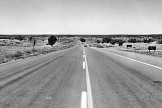
1964 Route 66 in Houck AZ. Looking west. Credits
Click image to enlarge
St. Anselm Mission in Houck
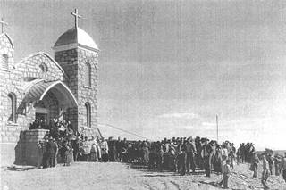
St. John church, Houck. Credits
On the south side of the freeway. 0.6 mi. from the "Fort" (map) is the mission that Father Anselm Weber began in 1900. He helped the Navajos obtain legal title to their lands to protect them from being evicted into the reservation. Nakai Chee deeded five acres of his land to the mission. A chapel was built there and dedicated to St. John the Evangelist in November 1927. The stone building is still standing. A school was built next to it in 1932. It closed in 1964.
Querino on the 1930-47 Route 66
Box Canyon and Big Arrows Trading Post
Head back to the north side of the freeway and follow the North Frontage Road westwards. Ahead the freeway turns towards the SW, the old '66 heads west. About 3 miles west of Houck, there is a bridge across Box Canyon. This is an original 1930 bridge.
Ahead, after passing by the "new" Querino Trading Post at the junction with Hwy 9407, the old highway passes by the ruins of "Old Querino Trading Post" mentioned by Rittenhouse right next to the deep Querino Canyon and the historic bridge that spans it. It is 4 mi. west of Houck
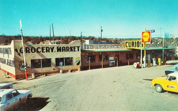
This was the Big Arrows Trading Post that was once owned by Claude and Clara Lee. Nowadays an old chimney and a column stand among the rubble. Rittenhouse described it in 1946 as "another one-structure "town," consisting of the Querino Trading Post. Curios and gas." They moved to a new location close to Houck when the highway was realigned in 1949, building a second Big Arrows west of Houck that their daughter Arlene managed well into the 1960s. Below are two pictures in a "Then and Now" sequence of their original post at Querino Canyon:

Querino Trading post in ruins. Credits

Remains of the Querino Trading Post. Credits
Historic Querino Canyon Bridge
Listed in the National Register of Historic Places

Querino Canyon bridge seen from I-40. A. Whittall. St. View
Click on image to enlarge
Located on Old Route 66, 4 miles west ofHouck, AZ.
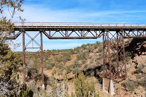
Historic bridge built in 1929 across the deep Querino Canyon on U.S. Highway 66. The Arizona Highway Department decided to shorten the 1926 US66 alignment and avoid crossing the Puerco River twice to do so it laid down a this new roadbed westwards from Houck to Sanders, it only required a big bridge at this canyon. The bridge is 77 ft. long and 20 ft. wide with a steel tressle supported by very tall steel piers rising from the canyon's bed.
It has 307 cubic yards of concrete 288,000 pounds of structural steel and 34,000 pounds of reinforced steel. It was built by F.D. Shufflebcager of Phoenix. Route 66 ran along this alignment an across this bridge until a newer alignment was build in 1947 where I-40 is now located. The bridge is still in use and is part of the local highway network.
The name: Querino
The Arizona Territory map of 1880 shows it as "Quirino." The surname Quirino also "Chirino" is of Spanish origin, and was the name of Ginés Perez Chirino a disciple of Saint Julian, the second bishop and patron of the Spanish city of Cuenca in AD 1200. Ginés was the son of the Conqueror of Cuenca, who took the city from the Moors in AD 1177. They were a noble family from Galicia.

Houck to Chambers, detail of 1937 map. Source
Click on image to enlarge
One mile west, Rittenhouse mentions a Trading Post that didn't sell gas. This aerial photo from 1969 shows the building, that is still standing.
The 1937 map from Houck to Chambers (click on it to enlarge) shows the buildings along Route 66.
Highway continues towards the SW and meets the freeway, where it turns west as the North Frontage Rd. The original 66 here runs beneath the freeway towards Cedar Point, just ahead at Exit 341.
1947 Realignment bypassing Querino
The Querino Canyon and the Box Canyon bridges were bypassed with the 2-lane upgrade of the highway that runs where the eastbound lanes of I-40 run. The original bridges on this alignment were also replaced in the late 1970s.
The Second Big Arrows
The Lee's moved to the new alignment and built their second Big Arrows on the north side of the highway (right), with a Shell station. It was located just 0.5 mi west of Houck's Exit 346 as shown in this Satellite view the drives and parking area can still be seen from space, the building has gone. You can see the complex in this 1970 aerial photo. Below is a postcard of the Big Arrows, which had big arrows next to the building (you can see them in the postcard).
Continue your Road Trip
Continue your Route 66 road trip by heading west into Sanders.
National and State Parks, Outdoors
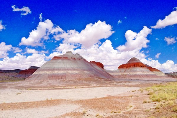
Petrified Forest National Park
Tip: consider visiting the Petrified Forest National Park (further west, as you approach Holbrook) during your Road Trip.
The Only National Park on Route 66

Sponsored Content
Lake Havasu City

Lake Havasu City, the lake and London Bridge. Source
The resort town of Lake Havasu City on Lake Havasu has beaches along the lake's scenic shoreline, an active nightlife and the original London bridge (you can take a Tour to visit it)
The adjacent state park is open 24 hs, and there is an entrance fee. It is located on a reservoir on the Colorado River. You can hike and enjoy the riverside.
Visit the scenic shoreline with beautiful beaches, nature trails, boat ramps, and many convenient campsites.
>> Book your Hotel in Lake Havasu City
Learn more about the outdoor sites in the Havasu State Park official website.
>> Book your Hotel in Holbrook AZ

Credits
Banner image: Hackberry General Store, Hackberry, Arizona by Perla Eichenblat
Jack DeVere Rittenhouse, (1946). A Guide Book to Highway 66
Stefan Joppich's The alignments of Route 66 through Arizona (2004).


