Your Route 66 Road Trip through Newburg
Index to this page
About Newburg Missouri
Facts, Trivia and useful information
Elevation: 715 ft (218 m).Population 470 (2010).
Time zone: Central (CST): UTC minus 6 hours. Summer (DST) CDT (UTC-5).
The town of Newburg is not located on Route 66, it is 2.2 miles south of it. Route 66 goes through its distant outskirts. It is located in Phelps County, South central Missouri.
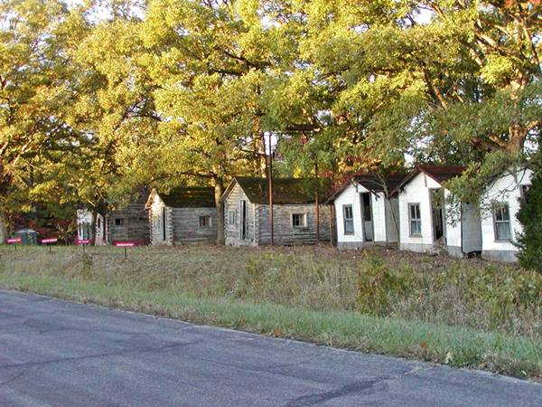
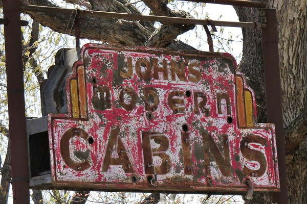
John’s Modern Cabins, Route 66 in Newburg, Missouri
History of Newburg
For the general history of the area check the History of Rolla, the county seat.
The first trail in the area was one opened by wild animals and later used by Indians and white explorers and trappers. They called it the "Great Osage Trail" (after the Osage Indians).
First settled by William Coppedge in 1823 who manufactured gunpowder using saltpetre from a nearby cave. Capt. C. W. Rogers platted it in 1883, to establish a division point on the St. Louis and San Francisco Railroad.
Originally named Newburgh (with a final "h") by William Painter, it incoporated in 1888. But the post office was named "Newburg" so the town followed suite becoming Newburg. It prospered as an industrial town, servicing the railway's locomotives, and although it closed in the 1940s, it is used by the Burlington Northern Santa Fe Railroad as a maintenance stop.
The name: Newburg
The name means new town or village.
The "Wire Road" was built during the 1860s to service the telegraph line that ran from St. Louis to Fort Smith in Arkansas, it ran north of Newburg. The 1909 USGS map shows the Wire Road running from Arlington to Rolla along Pea Ridge. There was another road from Newburg to Arlington through the Little Piney River valley next to the railroad.
In the 1920s, the Wire Road was improved and it became State Higway No. 14. In 1926, it was gravelled andbecame part of U.S. 66.
The road was upgraded to a four-lane highway in the 1950s, and realigned in 1966, to improve it further. Finally in 2003-6 the freeway which had replaced Route 66 was realigned to the west, bypassing Newburg completely.

Find accommodation near Newburg, Missouri
There is no lodging on this section of Route 66, but you can find your hotel or motel close to Newburg in neighboring Rolla.
> > Book your hotel in neighboring Rolla
More Hotels and Motels along Route 66
There are several hotels in the area close to this town. Alternatively you can also find your accommodation along Route 66 in the neighboring towns and cities in Missouri. We list them below (from east to west):
On Route 66's Main alignment in MO
Eastwards
Westwards
- Hotels in Kansas
- Baxter Springs KS
- Galena KS
- Riverton KS
- Hotels in Oklahoma
- Miami OK
>> Check out the RV campground in neighboring Rolla
Weather in Newburg
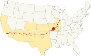
Location of Newburg on U.S. Hwy. 66
The weather in Newburg has clearly defined seasons and is combines both humid continental and humid subtropical climates. During winter (Jan), the average high is around 39°F (4°C) and the aveage low is a freezing 20°F (-7°C). The summer (Jul) average high is 89°F (32°C) with an average low of 68°F (20°C).
Rainfall average is 44.5 in. (1.130 mm) which ranges from 2.21 in (56 mm) in Jan. to 4.81 in (122.2 mm) in May.Snowfall is around 18.9 in. (48 cm), which falls from Dec. to Mar.
Tornado risk
Newburg is located in Missouri's "Tornado Alley" and Phelps County is hit by some 8 tornado strikes every year.
Tornado Risk:read more about Tornado Risk along Route66.
Map of Route 66 in Newburg
The original 1926 to 1953 alignment in Newburg was moved when the four-lane Route 66 was built here in 1953. It became the frontage road for the divided highway and what is now known as Outer Road W. and Arltigton Outer Rd.
This is the map showing Route 66's alignment in Newburg, which can be driven to reach Arlington. There it ends, so to continue your road trip westwards towards Jerome, you must return to I-44 and use the freeway to cross the Little Piney River.
As mentioned, the highway was upgraded to a four-lane roadway in 1953, the eastbound lanes of this highway used the original 1926 U.S. 66, and a second set of lanes were built to carry the westbound traffic. Two frontage roads were also added.
Then in 1966 a new eastbound set of lanes was built on the north side of the Little Piney River between Arlington and Arlington Heights, this left the Outer Rd. W as the only access to Arlington.
In 1981, the four-lane highway abandoned and I-44 was realinged between Exit 176 and Arlington, bypassing the old segment through Newburg. The roadbed was almost completely removed except for a short section near Exit 176.
The Route 66 alignment in Newburg
Visit our pages with old maps and plenty of information about US 66's alignments.
- Springfield to Joplin (next)
- Rolla to Springfield (in Newburg)
- Gray Summit to Rolla (previous)
Route 66 Sights in Newburg
The many alignments of Route 66 in Newburg
Historic context, the classic Route 66 in Newburg
The 1941 book, "Missouri, a guide to the "Show Me" state" published by the WPA does not mention the two towns east of this segment (Doolittle and Route 66 Newburg), it only mentions the turnoff into the town of Newburg: "At 6.9 m. is a junction with County T, a black-topped road. Left here to NEWBURG, 2.2 m (712 alt., 1,056 pop.), a railroad division point."
Jack DeVere Rittenhouse in his 1946 "A Guide Book to Highway 66" does not mention Newburg (obviously, as it was not located on the highway). He does mention this section in Newburg.
Totem Pole Cabins, built of logs. Just north of here is a roadside park (R) with wooden tables. Rittenhouse (1946)
He added that there was a gas station one mile west of the Totem Pole Cabins.
Drive along Route 66 in Newburg
Begin this part of your Route 66 road trip on the eastern tip of this segment. Right beside I-44's Exit 176, and drive west down old Route 66. This exit is the only access to US 66 from the Interstate and the road ends with a dead end in Arlington. So after driving this "1926 to 1970s Route 66 alignment" across Newburg and into Arlington (Map with directions - total round trip to Arlington 5.8 miles), you will have to drive back the same way and use I-44 to continue west of Arlington.
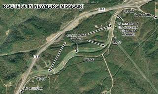
After the exchange at Exit 176, the old Route 66 coming from Doolittle curves south and, to your right you can make out the concrete roadbed of the abandoned four-lane Route 66 build in the early 1950s (see picture, notice the truck on the lower right, driving along modern I-44).
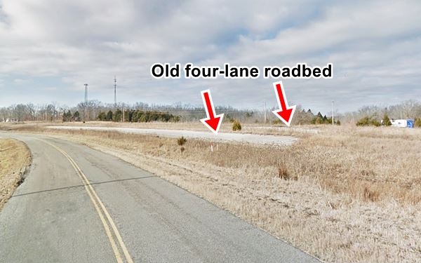
East of this point, the 1950s divided highway is buried beneath the freeway, and west of here the old roadbed has mostly been removed or covered with soil, but you can see them again at just ahead, at the access to Vernelle's.
Vernelle’s Motel
Head west, and to your right at 10891 Sugartree Outer Road, on what is now a dead end on the north frontage road of the now defunct four-lane Route 66 is a Classic Route 66 Motel. Vernelle's.

Vernelle's survived (Visit their website) of all the realignments in the area, including I-44's recent change of course in the mid 2000's, but it closed for good in 2016.
Vernelle's Motel Neon Sign
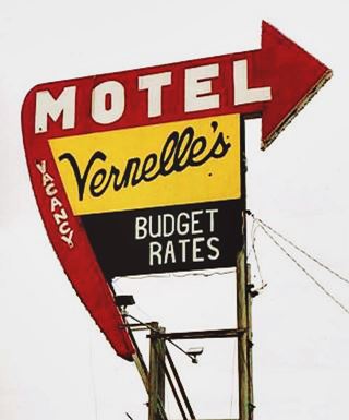
Neon sign of Vernelle's Motel on Route 66 in Newburg, MO. Source
Route 66 Classic Sign
Don't miss the neon sign (see image), it dates back to 1952 and is in pretty good shape after being restored in the mid 2000s by the Friends of the Mother Road.
The old Motel
It began in 1938 when E. Gasser built a service station with a store and six cabins, he named it "Gasser Tourist Court".
He sold out in 1952 to his newphew Fred who, with his wife Vernelle (1917-1915), renamed it after her and upgraded it by building a Cities Service station and a restaurant on the north side
of the property. Both were demolished when the four-lane Route 66 built in the 1950s.
A decade later, I-44 was built over the old US 66 freeway andthe interstate's wider right-of-way chopped a piece off their property including the restaurant (1968).
The place is still standing, though vacant.
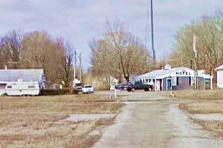
The "Then and Now" sequence below shows that the building with the word "Motel" written on it has survived, but the restaurant to the right, has been torn down. The gable roof building on the right, with a hip end, was a liquor store next to the gas station (gone) that in the 1960s sold Mobil gas.

Vernelle's Motel, 1950s postcard. Source
Just 400 feet west, along the old north frontage road are the decaying remains of "John’s Modern Cabins".
John’s Modern Cabins

Bill's Place, vintage postcard. Source
On the north side of W. Outer Rd, to your right, see this Map. The cabins are Private Property, dont tresspass. All of the buildings except one have decayed and collapsed.
They were Built in 1942 as "Bill's Place" (see picture), also known as "Bill and Bess' Tourist Camp", a primitive form of motel that predated regular motels. Bill and Beatrice "Bess" Bayless complex had six cabins and also a small dance hall. The Bayless sold out after WWII to John Dausch (1893-1971).
Dausch renamed it after himself; "John's Modern Cabins" (they were modern but had an outhouse!). The site included a store. Dausch also lost part of his land to I-44.
The cabins fell out of favor with travellers who sought better quality lodging (i.e. neighboring Vernelle's Motel), and eventually closed. Route 66 was decomissioned and I-44 replaced it, leaving the cabins on a frontage road, which became a dead end after I-44 was rerouted in 2003.
Route 66 Shield on the roadway

Thumbnail of US66 shield on roadway.
Credits, click to see large size image
Don't miss the large U.S. Highway 66 shield painted on the roadway.
It is one of many painted along the Mother Road. Be careful if you plan to take a picture next to it!
Read more about the Shields painted on Route 66.
Vanished Totem Pole Cabins
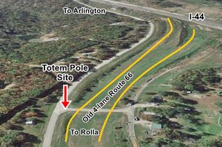
Continue west towards Arlington. The "Then and Now" set of images below (click on them to enlarge) look west towards Arlington. The yellow lines in the current view show the approximate location of the lanes of the "4-lane Route 66".

1950s aerial view of Totem Pole cabins. Click image to enlarge. Source

Original 1930s Totem Pole trading post. Source
Harry Cochran built the trading post in 1933, with a totem pole standing upright on its roof (see picture below). It evolved into a cafe, gas station, and shop.
It also had six cabins to lodge travelers. Unfortunately, when the highway was widened to a four-lane freeway in 1952 several buildings were razed.
At that time Charles and Velma Huntington ran the store. They sold it to Ralph Jones in 1957.
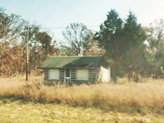
One cabin survives as you can see in the "Then and Now" sequence below. It housed the local laundromat next to the gas station.
To avoid being isolated from his customers as traffic drove by his store along the 4-lane Route 66, Jones moved in 1963 and relocated his store in Doolittle, where it was once again cut off from the highway.
So, finally, in 1977 he moved to its present location in Rolla, the original totem pole is inside the store.

Totem Pole Laundromat Cabin c.1950. Source
This leg of your Route 66 road trip through Newburg ends here. Continue west to visit neighboring Arlington, but remember that Arlington is on a dead end so you will have to retrace your steps back through Newburg to Exit 176 to take the freeway to be able to cross the Little Piney River and continue your journey west along Route 66, into Jerome.

Some sponsored content
> > Book your Hotel in Lebanon

Source
Banner image: Hackberry General Store, Hackberry, Arizona by Perla Eichenblat
Jack DeVere Rittenhouse, (1946). A Guide Book to Highway 66
Missouri: The WPA Guide to the "Show Me" State (1941)


