Your Route 66 Road Trip through Doolittle
Index to this page
About Doolittle Missouri
Facts, Trivia and useful information
Elevation: 1,004 ft (306 m). Population 575 (2024).
Time zone: Central (CST): UTC minus 6 hours. Summer (DST) CDT (UTC-5).
The town of Doolittle is located on Route 66, in Phelps County, South central Missouri Ozarks Region. Seven miles West of Rolla.
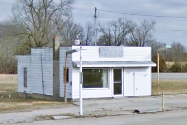
Malone’s Service Station, Route 66 in Doolittle, Missouri
History of Doolittle

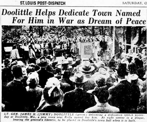
General James H. Doolittle
For the general history of the area check the history of the county seat: Rolla.
This was originally farmland between Rolla and Newburg. It grew halfway between Rolla and Newburg and was initially known as "Centertown".
When
Ft. Leonard Wood was established in 1941 during the days that preceded WWII, the area boomed, serving the workers that flocked to the region to work in building the fort.
The town grew on the open fields alongside Route 66 and was known as Doolittle after it was formally incorporated in 1944.
Gen. Doolittle flew into a nearby airport in 1946 and spoke at the town's formal dedication ceremony after it incorporated.
Doolittle Fun Fact
The town's streets are named after famous military (MacArthur, Eisenhower, etc.)
Regarding U.S. 66, the "Wire Road" built in the 1860s next to the St. Louis - Ft. Smith telegraph line became MO-14 in the 1920s and in 1926 it became part of U.S. 66.
The highway was upgraded to a four-lane road in the 1950s, and realigned in 1960s as I-44 to improve it further.
The name: Doolittle
James H. Doolittle, (1896 – 1993), a U.S. Medal of Honor Army general who fought in World War II, and commanded the famous "Tokyo Raid" of April 18, 1942: the first air strike in the Japanes Home Islands during WWII. It was a morale boosting raid that bombed Tokyo on a one way flight of 16 bombers from an aircraft carrier in the Pacific to landing fields in China. All planes crash landed and only 3 of the 80 crew members survived.
Surname of Irish origin, from Gaelic O Dubhlachta (where "Dubh" is: "black" and "lachta" derives from a Celt name); however, the Patronymica Britannica: A Dictionary of the Family Names of the United Kingdom" published in 1860, says that it is a nickname for a lazy man ("do" + "little").

Find your hotel close to Doolittle
There are no hotels in town. But just seven miles east you have plenty of options in the city of Rolla.
> > Book your hotel in neighboring Rolla
More Hotels and Motels along Route 66
There are several hotels in the area close to this town. Alternatively you can also find your accommodation along Route 66 in the neighboring towns and cities in Missouri. We list them below (from east to west):
On Route 66's Main alignment in MO
Eastwards
Westwards
- Hotels in Kansas
- Baxter Springs KS
- Galena KS
- Riverton KS
- Hotels in Oklahoma
- Miami OK
>> Check out the RV campground in Rolla
Weather in Doolittle
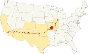
Location of Doolittle on U.S. Hwy. 66
The weather in Doolittle has well marked seasons and is the combination of humid continental and humid subtropical climates.
The winter (Jan), the average high is around 39°F (4°C) and the aveage low is a freezing 20°F (-7°C). The summer (Jul) average high is 89°F (32°C) with an average low of 68°F (20°C). Rainfall averages 44.5 in. (1.130 mm) yearly which ranges from 2.21 in (56 mm) in Jan. to 4.81 in (122.2 mm) in May. Snowfall is around 18.9 in. (48 cm), which falls from Dec. to Mar.
Tornado risk
Doolittle is located in Missouri's "Tornado Alley" and Phelps County is hit by some 8 tornado strikes every year.
Tornado Risk: read more about Tornado Risk along Route66.
Map of Route 66 in Doolittle

1951 map showing Doolittle Route 66, by the USGS
The original highway had a meandering course between Rolla and Doolittle (see image). In 1951 a new and straighter alignment was necessary, so a new roadway with two lanes was built eastwards towards Rolla.
It was then expanded to a four-lane alignment that bypassed the town on its northern side. It cut through a small curve of the 1926 alignment to the east of town (see map). This four-lane alignment was a divided highway with grade crossings.
Beginning in 1967 the old US-66 ⁄ I-44 Freeway was improved again to interstate standards and required overpasses. The original US66 alignment north of the freewat was cut off (see map). A new section of road was built on the south side of the freeway to link up the cut-off segments of Route 66.
See this the map of Route 66 in Doolittle.
The Route 66 alignment in Doolittle
Visit our pages with old maps and plenty of information about US 66's alignments.
- Springfield to Joplin (next)
- Rolla to Springfield (in Doolittle)
- Gray Summit to Rolla (previous)
Route 66 Sights in Doolittle
Landmarks and Places to See on your Road Trip
Historic context, the classic Route 66 in Doolittle
Jack DeVere Rittenhouse mentions it in his 1946 "A Guide Book to Highway 66".
DOOLITTLE, a community loosely strung along about two mi. of highway. (Pop. 208; Five-Oaks garage; gas; few cabins; cafe.) Rittenhouse (1946)
He also added that two miles east of it was a Gas Station.
War Hero Town on Route 66
This section of your Route 66 road trip begins on the eastern side of the town, coming from Rolla and driving west. Begin at Beaver Creek Bridge, recently replaced by a new one due to safety reasons.
Old Beaver Creek Bridge - Now gone
After Martin's Springs (described on our Rolla page), the highway makes a deep "U" with a towards the Beaver Creek bridge, that is located just after a "Dead Man's Curve" that was very dangerous, causing frequent automobile wrecks and honoring the highway's nickname of "Bloody 66".
The original bridge was a very narrow concrete slab structure; it was removed and replaced by a new safer bridge in 2021. Both bridges are pidctured below.

"New" Beaver Creek bridge. Source
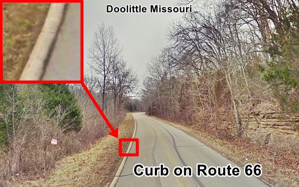
Curbs on the highway
When this part of Route 66 was paved in 1931 a new concept was tried: "Half curbs" that were supposed to keep the traffic on the highway and stop vehicles from wandering off the roadbed onto the shoulder. These curbs were also tested in Oklahoma (read about the Bridgeport OK "lip curbs" and Canute half-curbs).
The idea didn't work, these curbs were a hazard and caused rollovers.
Ahead the highway reaches the souther side of I-44's eastbound lanes. At one time Route 66 kept straight (now cut by the freeway), and on the north side of the interstate is the second location of the "Totem Pole Trading Post."
Totem Pole Trading Post
The first store was located in neighboring Newburg (see Totem Pole Cabins in Newburg), but when the four-lane U.S. 66 alignment was built, it cut the store off from its customers, so its owner, Ralph Jones, moved to a new location in Doolittle.
Unfortunately the four-lane highway in Doolittle would also cut off his store from the main flow of traffic. He relocated once again, in Rolla (See: Totem Pole Trading Post in Rolla).
The spot at 15990 County Rd 8140 later became the Gauntlet Paint and since 2005 it is an auction house. The picture looks east, the dashed line marks the roadbed of Route 66 cut by I-44.
If you want to drive this curved section on the north of the freeway, you have to head west into Doolittle and take the overpass there (map).
At this point Route 66 runs parallel to the freeway along its southern flank for 0.6 mi. This section was built to link the two parts of Route 66 that were cut by I-44.
Former Hargis Tourist Camp
At the point where Route 66 turns away from I-44 with a NE-SW course, to your left, once stood the old Hargis Tourist Camp or the "All American Camp" and his Texaco filling station. It had a row of cabins lined up perpendicular to the highway. Louis Hargis was also Arlington Township's Justice of Peace. On the eastern side of the property was the skating rink. The cabins are all gone, now a self storage site stands on the property, but the old roller rink he built is still there, as you can see in the image. Check this aerial photo from 1955, you can see the rink (right) and the line of cabins (left) on the south (bottom) side of the highway, notice how the old road is cut by the four-lane divided highway (now I-44).
Ramsey’s or Centerville Garage
Just ahead, also on your left is a classic garage and the remains of some cabins, "Ramsey's Garage" that began as "Centerville Garage" because it was roughly halfway between Rolla and Newburg.
Centerville Garage c.1930s
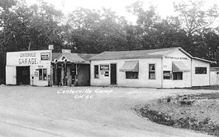

Ramsey's Garage in the 1930s. Click thumbnail to enlarge. Source
The business began operating in 1927 and was ran by Monroe and Hattie Ramsey until the 1950s when the highway became a four-lane freeway and was realigned north of town, bypassing it.
The thumbnail image (click on it to see a large size image), shows the garage and station in the 1930s. The stone wall to the right is still there! and you can see it in this street view. In 1941 they built the concrete block building that houses the garage, it has a false front stepped wall.
The Ramsey's had also built some cabins during WW II to lodge those coming and going from Ft. Leonard Wood. You can see one of them, and the foundations of another behind the garage building (red arrows in the image below).
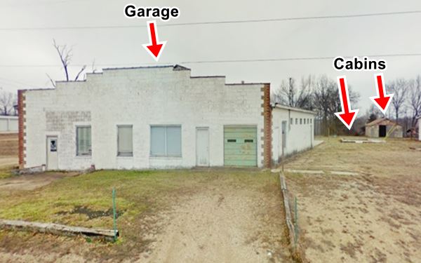
Head west for 0.7 mi. and at the main crossroads in "dowtown" Doolitle, on the NW corner of Eisenhower and Hwy T, is "Malone's Service Station".
Malone’s Service Station
Pictured above at the top of the page. This was the Hudson Oil Company, a very simple rectangular building which dates back to 1941. It sold Hudson Oil Co. gasoline. Hudson was a texan company. Dan Malone bought it in 1952 and he sold Tidewater, Flying-A and Cities Service lubes and gas. It had twelve pumps at one time and a restaurant which was demolished in the 60's when Highway T was improved.
Bennett's Doolittle Cafe
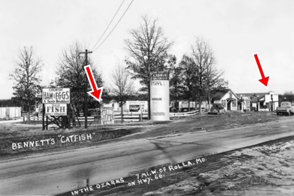
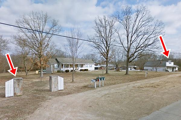
Head weast for 0.4 mi. to your right is the site (and some remains) of a classic Route 66 cafe. Paul and Gladys Bennett opened their Catfish Cafe here in 1942. Paul was a preacher (the "fishing, coon hunting preacher of the Ozarks").
He passed away in 1950, and one year after his death, Route 66 bypassed their store. Gladys decided to move it to a new location (see
Bennett's Catfish Cafe in Clementine). Then, in 1966 I-44 cut off the old U.S. 66 again, so she closed it for good. Below is a "Then and Now" sequence, notice the stone pillar and the building on the right, they have survived (red arrows).
Continue west for 0.8 mi. and when old Route 66 finally meets I-44 again, on your right you will see the former "T&T Cafe and Garage".
T &T Cafe and Garage

T&T Cafe in Doolittle, US66. Source
Now known as the "I-44 Antique Mall and Flea Market", it is a concrete block building which served as café and garage. It was built in 1952 and was named after Terrill and Tabor. Joe and Ruth Tabor owned it. They had originally ran a shop called Joe's Place but when US 66 became a four-lane higwhay and was realigned they built their new place facing it, and called it T&T.
Later it was managed by Hamilton Oil Co., and included a gas station. Now it is an antiques shop and flea market.
When I-44 was built in the 1960s following interstate standards it became a limited access freeway and T&T was cut off from their customers.
Nothing remains of the place (street view).
Your Route 66 road trip in Doolittle concludes here; head west to continue your journey and visit the four-lane alignment in neighboring Newburg.

Some sponsored content
> > Book your Hotel in Lebanon

Credits
Banner image: Hackberry General Store, Hackberry, Arizona by Perla Eichenblat
Jack DeVere Rittenhouse, (1946). A Guide Book to Highway 66


